
Hudson Valley Rail Trail
| Hudson Valley Rail Trail | |
|---|---|
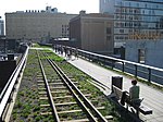
 The trail by the Commercial Avenue parking lot | |
| Length | 4 mi (6.4 km) |
| Location | Lloyd, Ulster County, New York |
| Trailheads |
|
| Use | Hiking, bicycling, horseback riding, roller blading, and cross country skiing. |
| Sights |
|
| Website | hudsonvalleyrailtrails.org |
The Hudson Valley Rail Trail is a paved 4-mile (6.4 km) east–west
During the 1990s, a
The bridge, now a
History
Declining rail usage

The Hudson Valley Rail Trail is part of the former rail
After Penn Central went bankrupt,
Conversion to trail

Parcels of the right-of-way between Lloyd and the neighboring
Lloyd received a $224,000 state and federal grant in the summer of 2000 to create such a connection.[18] Additional funding for the eastern extension was provided in November 2006, when the state granted $1.5 million to construct a bridge and a tunnel, and to complete the path.[19] Lloyd received a $7,500 grant in 2002 to extend the trail west to the Black Creek Wetlands Complex;[20] the town received an additional grant for $20,000 in May , 2005 to complete the Black Creek extension.[21]
In 2006, a local businessman donated an antique

Lloyd's police department became the first in the county to purchase a
In March 2009, Ulster County received almost $21 million in stimulus funds. The funding included a $3.16 million project to complete the trail between Lloyd and the Poughkeepsie Bridge.[30] Some funding for the architectural and engineering aspects of the project came from the reserve fund created after the town's fiber optic deal.[31] The Rail Trail Association also received a $1,500 grant from a public-benefit corporation, the Hudson River Valley Greenway, to print brochures.[32] Construction for the 1.28-mile (2.06 km)[16] section was underway by that September.[33] In March 2010, a portion of New Paltz Road was closed pending the replacement of a bridge over the trail.[34]
The official
Between June 23 and 24, 2011, parts of the trail were spray-painted with "dozens of [...] words and images".[29] Volunteers who removed some of the graffiti believed that different types of paint were used. Lloyd's highway superintendent noted similar vandalism elsewhere in the town, and Town Supervisor Ray Costantino stated that the incident would cause Lloyd residents to feel a personal connection to the trail and become outraged.[29]
As part of the Empire State Trail project, the trail was extended 2 miles (3.2 km) to the west, ending just past the New York State Thruway in New Paltz. The state also constructed an on-road connection between the Hudson Valley Rail Trail and the Wallkill Valley Rail Trail.[40] Prior to this construction, there has never been a direct link between the Poughkeepsie Bridge and the Wallkill Valley corridor.[41] Other plans include the development of commercial zones along the trail,[42] and a project to connect the trail to Illinois Mountain.[43]
Route

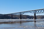
The east–west trail begins at the Poughkeepsie Bridge, by Haviland Road.
The Hudson Valley trail continues 0.5 miles (0.80 km) west from the Poughkeepsie Bridge to a bridge over Mile Hill Road, then another 0.1 miles (0.16 km) to a crossing at US 9W. At the 1-mile (1.6 km) mark, the trail reaches a bridge over Vineyard Avenue. About 1.5 miles (2.4 km) from the bridge, the trail crosses under New Paltz Road. Almost 0.5 miles (0.80 km) from this road, the trail reaches the Black Creek Wetlands Complex.[23] Black Creek is one of the two "principal streams" to run through Lloyd; it bisects the town as it flows north and pools in a pond.[47] The wetlands complex itself is important for water drainage.[48] Part of New York State Department of Environmental Conservation region 3, the complex contains Plutarch Swamp and one of the region's largest dwarf shrub bogs, hosting a variety of rare species. The complex also includes the Swarte Kill,[49] Lloyd's second major waterway.[47] The trail continues an additional 0.5-mile (0.80 km) past the beginning of the complex to Tony Williams Park.[23]
The trail was extended about 2 miles (3.2 km) west as part of the Empire State Trail project. This section parallels New York State Route 299, ending just west of the New York State Thruway in New Paltz. On-road connections are available connecting the western terminus to the Wallkill Valley Rail Trail.
There are five parking areas along the trail,[50] by Haviland Road, Commercial Avenue, the Rotary pavilion, at Tony Williams Park, and along Route 299 in Lloyd.[23] The trail is 12 feet (3.7 m) wide and 4 miles (6.4 km) long; it is paved with asphalt and suitable for hiking, bicycling, horseback riding, roller blading, and cross country skiing.[50]
In 2018, Hudson Valley law firm Mainetti & Mainetti, P.C. published an updated bicycle map that showed the proposed route of the Hudson Valley Rail Trail, and how it links the Walkill Valley Rail Trail and River-to-Ridge-Trail with the Dutchess County Rail Trail.[51]
See also
- List of rail trails in New York
- Rosendale trestle– another instance in which Conrail sold a bridge and adjoining rights-of-way for one dollar
References
- ^ "Routes on the Empire State Trail". Welcome to the State of New York. 2017-11-17. Retrieved 2019-04-25.
- ^
Arnold, Hallie (July 13, 2003). "Troubled waters: Supporters of walkway over river can't agree on funding". Journal Register Company. Retrieved January 10, 2011.
- ^ Sylvester 1880, p. 128.
- ^ Adams 1996, p. 213.
- ^ Mabee 2001, p. 242.
- ^ a b Penna & Sexton 2002, p. 211.
- ^ Mabee 2001, pp. 252–253.
- ^ Mabee 2001, p. 255.
- ^ Mabee 2001, pp. 261–262.
- ^ Pevsner, Donald (January 27, 2009). "Donald Pevsner: Worked on Bridge Preservation". Walkway Over the Hudson Oral Histories (Interview). Interviewed by Jason Schaaf. Hudson River Valley Institute. pp. 3–4. Archived from the original (PDF) on July 7, 2011. Retrieved January 12, 2011.
I said, 'how would you like to sell me the bridge for a dollar including the right of way between the shore and the New Paltz over pass of the Thruway, if I could find somebody that responsively with insurance, with maintenance, you know without having it become a dangerous derelict,' what we call in legal terms an attractive nuisance ... 'We just want to sell it to the first warm body,' that's direct (sic) quote as relayed to me by [a lawyer in Conrail's real estate department] ... they sold the bridge for $1 dollar along with the right of way which I negotiated out to the Thruway over past New Paltz, to a convicted bank swindler- felon named Gordon Schreiber Miller who operated out of a taxi cab office...
- ^ a b Mabee 2001, pp. 262–263.
- ^ "Trail of the Month: January 2010". Rails-to-Trails Conservancy. Retrieved January 12, 2011.
- ^ Mabee 2001, p. 263.
- ^ a b Mabee 2001, p. 264.
- ^ a b c d Díaz, Rafael (August 11, 2009). "Highland Rotary's Major Role in the Rail Trail" (PDF). Signals. 6 (3). Highland, NY: Hudson Valley Rail Trail Association: 3. Archived from the original (PDF) on July 23, 2011. Retrieved January 10, 2011.
- ^ a b c d Díaz, Rafael (May 21, 2010). "Eastward Expansion Is Ahead of Schedule" (PDF). Signals. 7 (2). Highland, NY: Hudson Valley Rail Trail Association: 3. Archived from the original (PDF) on July 23, 2011. Retrieved January 10, 2011.
- ^ a b c Mabee 2001, p. 273.
- ^
"Rail Trail funds now available for Lloyd". Dow Jones Local Media Group. January 25, 2001. Retrieved August 27, 2011.
- ^
"State grant to extend Rail Trail". Dow Jones Local Media Group. November 8, 2006. Retrieved January 10, 2011.
- ^
"Greenway council helps Black Creek trail project". Dow Jones Local Media Group. October 2, 2002. Retrieved August 27, 2011.
- ^
"Town gets state funds for trail improvements". Dow Jones Local Media Group. May 11, 2005. Retrieved August 27, 2011.
- ^
Gross, Hank (October 30, 2003). "Lead paint on old caboose at rail trail worries ex-councilman". Journal Register Company. Retrieved January 10, 2011.
- ^ a b c d e f "Rail Trail Brochure" (PDF). Hudson Valley Rail Trail Association. December 7, 2010. pp. 1–2. Archived from the original (PDF) on July 23, 2011. Retrieved September 2, 2011.
- ^ a b c
Horrigan, Jeremiah (October 31, 2007). "Caboose campaign controversy". Dow Jones Local Media Group. Retrieved January 10, 2011.
- ^ a b c "Rail trail moves toward completion". Mid-Hudson News Network. Statewide News Network. July 9, 2010. Retrieved January 10, 2011.
- ^ "Makeover For Cabooses" (PDF). Signals. 7 (1). Highland, NY: Hudson Valley Rail Trail Association: 4. January 11, 2010. Archived from the original (PDF) on July 23, 2011. Retrieved January 10, 2011.
- ^ a b c
Horrigan, Jeremiah (April 16, 2008). "Lloyd officer patrolling trail on electric scooter". Dow Jones Local Media Group. Retrieved January 10, 2011.
- ^ a b
Gross, Hank (December 14, 2007). "Lloyd police add Segway to fleet". Journal Register Company. Retrieved September 5, 2011.
- ^ a b c Labrise, Megan (July 7, 2011). "Whoops marks the spot: Hudson Valley Rail Trail vandalized". New Paltz Times. Kingston, NY: Ulster Publishing. Archived from the original on 2012-03-17. Retrieved July 9, 2011.
- ^
"Ulster County getting $20.7M in stimulus money for transportation projects". Journal Register Company. March 6, 2009. Retrieved January 10, 2011.
- ^ Quinn, Erin (May 18, 2010). "Walking hard: Hudson Valley Rail trail gains access to Hudson River foot bridge". Hudson Valley Times. Kingston, NY: Ulster Publishing. Archived from the original on 2010-12-18. Retrieved February 7, 2011.
- ^
"Greenway grants aid Ulster projects". Journal Register Company. November 8, 2009. Retrieved September 5, 2011.
- ^ "Walkway designated a National Recreation Trail". Mid-Hudson News Network. Statewide News Network. September 17, 2009. Retrieved January 10, 2011.
- ^
"Hudson Valley Rail Trail bridge to be replaced". Dow Jones Local Media Group. March 26, 2010. Retrieved January 10, 2011.
- ^ a b
Murphy, Meghan E. (May 5, 2010). "Hudson Valley Rail Trail to link to Walkway". Dow Jones Local Media Group. Retrieved January 10, 2011.
- ^ "Groundbreaking for Hudson Valley Rail Trail extension". Mid-Hudson News Network. Statewide News Network. May 5, 2010. Archived from the original on September 27, 2011. Retrieved January 10, 2011.
- ^ "Route 44/55 in Highland to close Friday". Mid-Hudson News Network. Statewide News Network. July 14, 2010. Archived from the original on September 27, 2011. Retrieved January 10, 2011.
- ^ Attachment to State Coastal Assessment Form: Walkway Over the Hudson: City of Poughkeepsie and Town of Lloyd. Walkway Over the Hudson: Final Design Report and Environmental Assessment. Bergmann Associates. February 8, 2008. p. 2.
- ^ Labrise, Megan (October 7, 2010). "Happy trails: Rail Trail East links hamlet with Walkway". New Paltz Times. Kingston, NY: Ulster Publishing. Archived from the original on 2011-07-17. Retrieved January 11, 2011.
- ^ Mark (November 6, 2009). "Ulster Trail Projects Receive Greenway Support" (Press release). Albany, NY: Hudson River Valley Greenway. Archived from the original on July 26, 2011. Retrieved November 3, 2010.
- ^ Mabee 1995, p. 80.
- ^ Labrise, Megan (September 22, 2010). "Overlay okay: Lloyd planning board eyes new rail-trail zone". New Paltz Times. Kingston, NY: Ulster Publishing. Archived from the original on 2011-07-17. Retrieved January 11, 2011.
- ^
Kemble, William J. (January 30, 2006). "Report is due out on trail links". Journal Register Company. Retrieved January 11, 2011.
- ^ "Bridge Facts". Walkway Over the Hudson. Archived from the original on October 17, 2011. Retrieved October 2, 2011.
- ^
"Walkway Over Hudson tapped as a National Recreation Trail". Journal Register Company. September 18, 2009. Retrieved January 13, 2011.
- ^
"Rail Trail to connect Highland with Poughkeepsie". YNN. Time Warner Cable. May 4, 2010. Retrieved August 26, 2011.
- ^ a b Sylvester 1880, p. 124.
- ^
Medenbach, Deborah (September 26, 2008). "Land Trust aims to preserve wetlands areas". Dow Jones Local Media Group. Retrieved January 18, 2011.
- ^ "2009 New York State Open Space Conservation Plan" (PDF). New York State Department of Environmental Conservation. June 11, 2009. p. 74. Retrieved January 19, 2011.
- ^ a b "About the Rail Trail". Hudson Valley Rail Trail Association. Retrieved January 11, 2011.
- ^ "Two Maps for Avoiding Bicycle Accidents in New Paltz, Highland and Poughkeepsie - Mainetti & Mainetti, P.C." Mainetti & Mainetti, P.C. 2018-10-31. Retrieved 2018-11-02.
Bibliography
- Adams, Arthur G. (1996). The Hudson River Guidebook (2nd ed.). Ramsey, NJ: ISBN 978-0-8232-1679-6.
- Mabee, Carleton (1995). Listen to the Whistle: An Anecdotal History of the Wallkill Valley Railroad. Fleishmanns, NY: Purple Mountain Press. ISBN 978-0-935796-69-8.
- Mabee, Carleton (2001). Bridging the Hudson: The Poughkeepsie Railroad Bridge and Its Connecting Rail Lines: A Many-Faceted History. Fleishmanns, NY: Purple Mountain Press. ISBN 978-1-930098-25-1.
- Penna, Craig Della; Sexton, Tom (2002). The Official Rails-to-Trails Conservancy Guidebook. Guilford, CT: Globe Pequot Press. ISBN 978-0-7627-0450-7.
- Sylvester, Nathaniel Bartlett (1880). History of Ulster County, New York, with Illustrations and Biographical Sketches of its Prominent Men and Pioneers: Part Second: History of the Towns of Ulster County. Philadelphia, PA: Everts & Peck. OCLC 2385957.
External links
| Albany |
|    |
|---|---|---|
| Allegany | ||
| Cattaraugus | ||
| Cayuga | ||
| Columbia | ||
| Delaware | ||
| Dutchess | ||
| Franklin | ||
| Livingston | ||
| Monroe | ||
| New York | ||
| Ontario | ||
| Orange | ||
| Oswego | ||
| Putnam | ||
| Rockland | ||
| St. Lawrence | ||
| Schenectady |
| |
| Suffolk |
| |
| Ulster |
| |
| Westchester | ||
| Wyoming | ||