
Wallkill Valley Rail Trail
| Wallkill Valley Rail Trail | |
|---|---|
National Recreation Trail, 2007[3] | |
| Trailheads | |
| Use | Hiking, jogging, bike riding, horseback riding, and cross-country skiing |
| Sights |
|
| Website | Wallkill Valley Land Trust |
The Wallkill Valley Rail Trail is a 23.7-mile (38.1 km) rail trail and linear park that runs along the former Wallkill Valley Railroad rail corridor in Ulster County, New York, United States. It stretches from Gardiner through New Paltz, Rosendale and Ulster to the Kingston city line, just south of a demolished, concrete Conrail railroad bridge that was located on a team-track siding several blocks south of the also-demolished Kingston New York Central Railroad passenger station. The trail is separated from the Walden–Wallkill Rail Trail by two state prisons in Shawangunk, though there have been plans to bypass these facilities and to connect the Wallkill Valley Rail Trail with other regional rail-trails. The northern section of the trail forms part of the Empire State Trail.[5]
Plans to create the rail trail began as early as 1983, when New Paltz considered uses for the then-defunct Wallkill Valley rail corridor; the railroad had ceased regular traffic in 1977 and, by 1983, had begun to remove its
The trail serves hikers, joggers, bikers, horseback riders and cross-country skiers. It passes through several historic districts, such as
History

Stretching 33 miles (53 km)
While Montgomery and Shawangunk purchased their sections of the railroad – 2.0 and 2.3 miles (3.2 and 3.7 km), respectively
New Paltz and Gardiner

Converting the former corridor to a rail trail was first considered in a 1983 environmental report commissioned by the town of New Paltz.
While the town and village of New Paltz immediately purchased their sections from the Wallkill Valley Land Trust, with conservation easements on them – roughly 4 and 3 miles (6.4 and 4.8 km), respectively[25] – Gardiner did not purchase its 6-mile (9.7 km) section until much later; again, at that time, the Wallkill Valley Land Trust stewards held the conservation easements.[26][27] Portions of the New Paltz–Gardiner section were informally open since June, 1991, but the formal opening ceremony of the full 12.2-mile (19.6 km)[2] trail between New Paltz and Gardiner took place on October 9, 1993.[28]

The Gardiner section was in such a state of disrepair in 2004 that the Wallkill Valley Land Trust almost closed it.[29] Gardiner received a $100,000 grant from the New York State Office of Parks, Recreation and Historic Preservation in December 2006,[30] and the purchase was completed in 2007.[27] The state provided an additional $5,000 to maintain the trail.[31]
Purchasing the section allowed Gardiner to fix the drainage problems that had deteriorated the surface of the trail and to ban the use of motor vehicles. Though the section was worth $307,300, the Wallkill Valley Land Trust sold it to Gardiner for $70,000.[29]
In 2009 and 2010, the
Rosendale
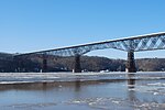
The Rosendale portion of the rail bed runs 11.5 miles (18.5 km) from Rosendale through Ulster to Kingston and contains the 940-foot long (290 m)
Conrail sold the Rosendale section, including the bridge, in 1986 to a private area businessman, John E. Rahl, for one dollar. Rahl maintained that the purchase granted him the right to "restore rail service on the whole Wallkill line",
After Rahl failed to pay $13,716 in property taxes over a period of three years,[39] Ulster County foreclosed on the 63.34-acre (25.63 ha) property on April 15, 2009. The Wallkill Valley Land Trust and Open Space Institute placed a bid on the land parcels comprising the Rosendale section on April 22, 2009,[49] and agreed to pay all outstanding taxes before receiving full ownership on July 8, 2009,[50] with the intention of adding it to the Wallkill Valley Rail Trail.[51] Following an engineering survey, the bridge was closed to the public in June 2009, for repairs.[52][53] Renovations were completed in 2013, allowing for the bridge to be opened to the public.
Canopy Development, a
A regional business association has proposed a link between the trail, in Rosendale, and a series of regional rail trails. The proposal would create a 35-mile (56 km) network of rail trails across the towns of Marbletown, Rochester, and Wawarsing.[59] Several involved towns have been working toward accomplishing such a connection.[60]
Route

The trail begins at Denniston Road, in the southern part of the
Located within the hamlet are a defunct, former dairy creamery and the site of the former Gardiner railroad station.[63] Built in 1881[64] and opened the following year, the creamery was one of the dairies that transported its products to New York City by way of the Wallkill Valley Railroad.[63] It was originally the property of the Borden family, but closed in the 1920s,[64] and has since been renovated as an apartment complex.[29] The former Gardiner railroad station ceased operations when the rail line closed. It became a sporting goods store by 1981,[65] a video store by the early 1990s,[66] and an antique store by 1995.[67] The station burned down on October 10, 2002.[66]
The trail crosses Phillies Bridge Road 1 mile (1.6 km) north of the hamlet, with an overpass carrying the trail over Forest Glen Road 3⁄4 mile (1.2 km) farther. The road overlies the Catskill Aqueduct and Delaware Aqueduct.[68] Originally supported by trestles and a stone foundation, the overpass was rebuilt in 1910 during the construction of the Catskill Aqueduct. The reconstruction removed the trestles and added a concrete foundation. Though a local legend holds that the bridge was originally built in response to the death of a prominent woman at the Forest Glen railroad crossing, it is more likely that it was built to maintain the rail line at a consistent grade.[69] A little over 1⁄10 mile (0.16 km) from the bridge is the site of the former Forest Glen station.[70] The trail crosses Bridge Creek Road and Old Ford Road about 1⁄4 and 1 mile (0.40 and 1.61 km) from the Forest Glen bridge, respectively, before entering the town of New Paltz.[68]

Shortly after entering New Paltz, the trail crosses a bridge over Plattekill Creek.[68] The masonry for the bridge was completed by late June 1870,[71] and trestle work was done by July.[72] Originally made of wood, the bridge was accidentally set on fire in 1880 by ashes or sparks from a passing train. This prompted the railroad to coat its rail ties with tin while replacing its wooden bridges with ones made of stone.[73][74] The bridge's original abutments were made of Shawangunk conglomerate. It was rebuilt in 1912, and crosses the Plattekill Creek at a height of 35 feet (11 m).[75] The Shawangunk Ridge is visible from the bridge.[68]
Plains Road is shortly after the bridge, and the trail continues for 3⁄10 mile (0.48 km) before crossing Cedar Lane. It crosses Plains Road again after another 1+1⁄5 miles (1.9 km), reaching the Sojourner Truth park in the village of New Paltz.[76] The trail is connected to the park via a small footbridge constructed in 2010 by the Alexandria, Minnesota–based construction company Contech. It has a weight limit of 5 short tons (4.5 t)[38][77] and is able to withstand earthquakes.[78]
At the edge of the park, the trail crosses Water Street and enters the Water Street Market, a "restored area of boutiques, galleries, and cafés". It then crosses State Route 299 and passes La Stazione, the former railroad station.[76] The refurbished depot had been originally built in 1870,[79] rebuilt after a 1907 fire,[80] and sold to private interests in 1959.[81] The building was in a state of disrepair by the early 1980s,[82] but renovated in 1988[83] and converted to an Italian restaurant in 1999.[84] Over the next 1⁄2 mile (0.80 km), the trail passes North Front Street, Broadhead Avenue, and Mulberry Street. After another 1⁄2 mile (0.80 km) the trail traverses Huguenot Street,[76] a historic district containing colonial-era stone houses. Some of the houses date to the late 1600s.[85]

About 1 mile (1.6 km) from Huguenot Street, the trail reaches the 413-foot (126 m) Springtown bridge spanning the
The trail continues west of the Wallkill River. Roughly 1+1⁄2 miles (2.4 km) from the Springtown bridge, the trail crosses Cragswood Road. Another 3⁄10 mile (0.48 km) farther, it reaches the New Paltz–Rosendale boundary line, continuing another 3 miles (4.8 km) on formerly private property to Mountain Road in the
Recreation
The road between the former railroad station and Water Street Market was the first site of a new town crosswalk system that opened on March 29, 2008.[95] Under the new system, pedestrians can use flags placed in roadside containers to signal traffic.[96] The trail connects with the Sojourner Truth park, which has had access to the Wallkill River for kayaking and canoeing since April 27, 2003.[97] The Minnewaska Preserve and Mohonk Preserve, featuring 60 miles (97 km) of combined walkways, can be reached through New Paltz.[98]

The trail connects to the Binnewater Historic District in Rosendale. The district was the location of several local quarries which opened throughout the region after the 1825 discovery of rocks capable of producing Rosendale cement in the nearby hamlet of High Falls. At its peak, the district was producing 4,000,000 barrels a year and employed 5,000 people.[99]
Though the Binnewater rail station was once part of the historic district,[100] it was located too close to Binnewater Road and was hit repeatedly by trucks until it fell apart in May 1989. The station was subsequently demolished by the county highway department.[101] Another historic district, the Snyder Estate, runs along the Rosendale section. The Snyder Estate is a former mining site once used by all four major regional cement producers.[100] The Rosendale trestle has been the site of numerous picnics, barbecues, and at least one wedding. One person has tried bungee jumping off the bridge without a restraining cord.[102]
Several
Surface
The surface of the Rail Trail is mostly gravel, while road crossings are paved. Mountain bikes are recommended to traverse to trail by cycle, as the trail is fairly rough. Cars are not allowed on the trail. In the winter, you can do cross-country skiing on the trail.
Flora and fauna

Flora along the northern end of the trail includes
Many animals pass through the trail unobserved, leaving behind
In popular culture
The Springtown Truss Bridge was used as a location for key scenes in the
See also
- Walden–Wallkill Rail Trail – the southern continuation of the former rail corridor
References
- ^ a b "Wallkill Valley Rail Trail Length Doubles". Open Space Institute. 2009-08-31. Retrieved 2010-11-01.
- ^ a b "History of the Trail". Wallkill Valley Rail Trail Association. Retrieved 2010-11-01.
- ^ a b "2007 National Recreation Trail designations". National Trails System. Archived from the original on 2010-10-25. Retrieved 2010-11-04.
- ^ a b Woods, Lynn (2013-09-13). "Rosendale link completes 24-mile stretch of rail trail". Almanac Weekly. Retrieved 2014-06-11.
- ^ "Routes on the Empire State Trail". Welcome to the State of New York. 2017-11-17. Retrieved 2019-04-25.
- ^ Mabee 1995, p. 40
- ^ Mabee 1995, pp. 50–51
- ^ Mabee 1995, p. 10
- ^ Mabee 1995, p. 135
- ^ Mabee 1995, p. 139
- ^
- "§18 Acquisition of abandoned railroad transportation property". Transportation Law. New York State Legislature. Retrieved 2011-04-03.
- "Railroad Corridor Abandonment in New York State" (PDF). NYS OPRHP. Retrieved 2010-11-02.
- ^ Mabee 1995, pp. 140, 142
- ^ "Shawangunk Correctional Facility" (PDF). Prison Visiting Project. Correctional Association of New York. July 2009. p. 1. Retrieved 2010-11-02.
- ^ Mabee 1995, p. 142
- ^ "Park Description and Program Schedules" (PDF). Walden, NY: Village of Walden Recreation and Parks. Retrieved 2010-12-26.
- ^ Mabee 1995, pp. 140, 144
- ^ Mabee 1995, pp. 140–141
- ^ Sisson, Angela; Hitchings, Crystal; Clague, Joshua (March 2004). "Town of Shawangunk Open Space Inventory and Analysis" (PDF). Conway, MA: Conway School of Landscape Design. pp. 68–69. Retrieved 2010-11-01.
- ^ a b "Ulster County Non-Motorized Transportation Plan" (PDF). Kingston, NY: Ulster County Transportation Council. December 2008. pp. 27, 29, 31, 37, 41. Retrieved 2010-11-07.
- ^ Rowley, Chris (2010-08-12). "A New Use for Prison Farmlands: Can Prison Lands Serve to Connect the Rail Trail System?". Shawangunk Journal. Ellenville, NY: Electric Valley Media LLC. Retrieved 2011-02-21.
- ^ Mabee 1995, p. 143
- ^ a b Penna & Sexton 2002, p. 182.
- ^ "Report on Potential Public Use of the Abandoned Conrail Right-of-Way". New Paltz Environmental Conservation Commission. August 1983.
- ^ Mabee 1995, pp. 141–143
- ^ a b c Mabee 1995, p. 141
- Dow Jones Local Media Group. 2006-12-30. Retrieved 2010-11-02.
- ^ a b "Wallkill Valley Rail Trail in Gardiner". Wallkill Valley Land Trust. Retrieved 2010-11-02.
- ^ a b Mabee 1995, p. 144
- ^ a b c "Acquisition and Development of the Gardiner Rail Trail" (PDF). Acquisition Application 2006 EPF Grant. NYS OPRHP. 2006-05-26. pp. 1–7. Retrieved 2010-11-07.
- ^ "Office of Parks, Recreation and Historic Preservation 2006 Trail Grant Awards" (Press release). NYS OPRHP. 2006-12-29. Retrieved 2010-11-06.
- ^ Bonacic, John J. (2007-04-02). "Bonacic Gives Ulster County Budget Report" (Press release). New York State Senate. Retrieved 2010-11-06.
- ^
- Horrigan, Jeremiah (2009-04-14). "Tax Day Tea Parties set to protest bailouts". Dow Jones Local Media Group. Retrieved 2010-11-06.
- "Calendar: July 4, 2010". Journal Register Company. 2010-07-04. Retrieved 2010-11-06.
- Horrigan, Jeremiah (2009-04-14). "Tax Day Tea Parties set to protest bailouts".
- ^ a b c d e Mark (2009-11-06). "Ulster Trail Projects Receive Greenway Support" (Press release). Albany, NY: Hudson River Valley Greenway. Archived from the original on 2011-07-26. Retrieved 2010-11-03.
- ^ Costantino, Claire R.; Bigelow, Joe (2009-12-12). "A Brief History of the Hudson Valley Rail Trail" (PDF). Hudson Valley Rail Trail. p. 1. Retrieved 2010-11-03.
- ^ Labrise, Megan (2010-10-07). "Happy trails: Rail Trail East links hamlet with Walkway". New Paltz Times. Kingston, NY: Ulster Publishing. Retrieved 2011-01-11.
- ^ Mabee 1995, p. 80
- Journal Register Company. Retrieved 2010-11-03.
- ^ Journal Register Company. Retrieved 2010-11-03.
- ^ Dow Jones Local Media Group. Retrieved 2010-11-01.
- Journal Register Company. 2010-06-13. Archived from the originalon 2012-03-04. Retrieved 2011-04-03.
- ^ Mabee 1995, pp. 18–20
- ^ "A Bit of Extraordinary Railroad History–The Great Rosendale Bridge of the Wallkill Valley Railroad–Other Railroad Items" (PDF). The New York Times. 1872-03-19. Retrieved 2010-11-03.
- ^ Rahl, John (1998-04-15). "Re: Finance Docket No. 33388 Joint Ownership of Conrail" (PDF). Retrieved 2010-11-23.
- ^ a b "Minutes of the April 20, 2004 Meeting". Zoning Board of Appeals Minutes. Town of Rosendale. 2004-04-20. Archived from the original on 2011-07-17. Retrieved 2010-11-04.
- Journal Register Company. Archived from the originalon 2012-03-18. Retrieved 2010-11-22.
- ^ a b "Minutes of the May 20, 2003 Meeting". Zoning Board of Appeals Minutes. Town of Rosendale. 2003-12-16. Archived from the original on 2010-08-22. Retrieved 2010-11-04.
- ^
- Zezima, Katie (2005-10-30). "Carolyn Kaplan and Douglas Hase". The New York Times. Retrieved 2010-11-22.
- Kladko, Brian (2006-12-31). "Balloon operator gets hot over trade secret battle". Boston Business Journal. Boston, MA: American City Business Journals. Retrieved 2010-11-22.
- Journal Register Company. Retrieved 2011-04-03.
- ^ "Ways and Means Committee Minutes for April 15, 2009" (PDF). Ulster County. 2009-05-07. Retrieved 2010-11-04.
- ^ "Resolution No. 215 Authorizing The County Commissioner Of Finance To Accept Bids On Parcels Of County Owned Property To Be Used For Public Use And Benefit And Authorizing The Chairman To Convey Property To Open Space Conservancy, Inc., And Wallkill Valley Land Trust, Inc" (PDF). Ulster County. 2009-07-22. Retrieved 2010-11-04.
- ^ "New Addition to the Wallkill Valley Rail Trail". New Paltz, NY: Wallkill Valley Land Trust. August 2009. Archived from the original on July 6, 2010. Retrieved 2010-11-01.
- ^ "Hanging by a Thread: Engineers Start Inspection on the Railroad Bridge" (Press release). Open Space Institute. 2010-11-15. Retrieved 2010-11-18.
- ^ Dow Jones Local Media Group. Retrieved 2010-11-01.
- ^ Woods, Lynn (2009-07-13). "Canopy Resort Would Bring Upscale Ambience to Rosendale". HV BIZ. White Plains, NY: Westfair Business Publications. Retrieved 2010-11-01.
- ^ "Meeting Minutes, November 16, 2009 UC Trails Advisory Committee" (PDF). Ulster County. 2009-11-16. p. 2. Retrieved 2010-11-07.
- ^ Botton, Sari (2007-09-23). "With an Upscale Spa, a Clash of Meanings for the Word 'Green'". The New York Times. Retrieved 2010-11-23.
- Dow Jones Local Media Group. Retrieved 2010-11-01.
- Dow Jones Local Media Group. Retrieved 2011-03-15.
- Journal Register Company. Retrieved 2011-03-02.
- ^ Schoenfeld, Gregory (2010-09-16). "The Trail to Recovery: The RVBA Leads the Way to a Continuous Rondout Valley Rail Trail". Shawangunk Journal. Ellenville, NY: Electric Valley Media LLC. Retrieved 2011-03-02.
- ^ a b Perls 2003, p. 340.
- ^ Penna & Sexton 2002, p. 191.
- ^ a b Mabee 1995, pp. 90–95.
- ^ a b Penna & Sexton 2002, p. 190.
- ^ Mabee 1995, p. 137
- ^ a b Mabee 2003, p. 22.
- ^ Mabee 1995, p. 152
- ^ a b c d Perls 2003, p. 341
- ^ Mabee 1995, p. 72
- ^ Penna & Sexton 2002, p. 189.
- ^ New Paltz Times. New Paltz, NY. 1870-06-30.
{{cite news}}: Missing or empty|title=(help) - ^ New Paltz Independent. New Paltz, NY. 1870-07-14.
{{cite news}}: Missing or empty|title=(help) - ^ a b Mabee 1995, pp. 12–13
- ^ Mabee 1995, p. 61
- ^ a b A placard affixed to the Plattekill Creek bridge by the Wallkill Valley Rail Trail Association.
- ^ a b c d Perls 2003, p. 342
- ^ A placard affixed to the bridge.
- ^ Alter, Maxim (2010-03-05). "De-Railed on the Trail". New Paltz Oracle. Vol. 81, no. 17. New Paltz, NY: SUNY New Paltz. p. 5. Retrieved 2010-11-26.
- ^ New Paltz Times. New Paltz, NY. 1870-09-01.
{{cite news}}: Missing or empty|title=(help) - ^ New Paltz Independent. New Paltz, NY. 1907-12-31.
{{cite news}}: Missing or empty|title=(help) - ^ "'No Bar in R.R. Station', Zoning Bd. Of Appeals". New Paltz News. New Paltz, NY. 1977-04-13.
- )
- ^ "New Paltz rail station to become real estate office". Huguenot Herald. 1988-01-07.
- Dow Jones Local Media Group. 1999-07-02. p. 24.
- ^ "Trail of the Month: October 2002". Rails-to-Trails Conservancy. Retrieved 2010-11-05.
- ^ Chazin 2001, pp. 289–290.
- ^ New Paltz Independent. New Paltz, NY. 1870-12-15.
{{cite news}}: Missing or empty|title=(help) - ^ Documents of the Senate of the State of New York. Vol. 2. Albany, NY: Weed, Parsons and Company. 1885. p. 320.
- ^ Mabee 1995, pp. 128–130
- ^ Mabee 1995, pp. 143–144.
- ^ Perls 2003, pp. 342–343
- ^ "Rosendale trestle opens to public, extending rail trail". Daily Freeman. 2013-06-30. Retrieved 2014-06-11.
- ^ "Double 'Wow" on Rail Trail: Rosendale Railroad Span, Extension to Open Saturday". Poughkeepsie Journal. June 25, 2013. Retrieved July 14, 2013.
- ^ Schoenfeld, Gregory (2010-05-27). "Extended Wallkill Valley Rail Trail Will Span Historic Rosendale Trestle". Shawangunk Journal. Ellenville, NY: Electric Valley Media. Retrieved 2011-02-11.
- ^ Burke, Caitlin (2008-04-03). "Village of New Paltz Introduces PedFlags". New Paltz Oracle. Vol. 79, no. 18. New Paltz, NY: SUNY New Paltz. Retrieved 2010-11-19.
- ^ Story, Victoria (2008-03-27). "Flags to Aid Pedestrian Safety". New Paltz Oracle. Vol. 79, no. 17. New Paltz, NY: SUNY New Paltz. Retrieved 2010-11-19.
- ^ Nyquist, Tom; Cotton, Tom; Danskin, Vici (2003-04-24). "Mayor Nyquist Encourages Voting". New Paltz Oracle. Vol. 74, no. 21. New Paltz, NY: SUNY New Paltz. Retrieved 2010-11-19.
- ^ "Wallkill Valley Rail Trail". Rail Trails in New York. A1 Trails. May 2003. Retrieved 2010-11-09.
- ^ a b Larson, Neil G. (September 1982). "Binnewater Historic District" (Java). National Register of Historic Places Registration. NYS OPRHP. p. 5. Retrieved 2010-11-09.
- ^ a b c d "Snyder Estate Natural Cement Historic District" (Java). National Register of Historic Places Registration. NYS OPRHP. 1992. pp. 2, 19, 22. Retrieved 2010-11-09.
- ^ a b Mabee 1995, p. 140
- ^ a b Genero 2005, p. 9.
- ^ "Ten Terrific Rail & Canal Trails in New York" (PDF). Albany, NY: Parks & Trails New York. p. 4. Retrieved 2010-11-05.
- ^ New York – New Jersey Trail Conference. Retrieved 2010-11-05.
- ^ a b Chazin 2001, p. 289.
- ^ a b "Frequently Asked Questions". Town of Gardiner. Retrieved 2010-11-05.
- ^ "The Wallkill Valley Rail Trail" (PDF). Wallkill Valley Rail Trail Association. p. 2. Retrieved 2010-11-19.
- ^ "The Ulster–Poughkeepsie Link and MTA Metro-North Railroad" (PDF). MTA. p. 1. Retrieved 2010-11-19.
- ^ Dow Jones Local Media Group. Retrieved 2011-01-01.
- ^ "Ulster County Commuter Parking Facilities Capacity Analysis and Needs Assessment" (PDF). Ulster County. 2008-12-17. p. 3. Retrieved 2011-01-01.
- ^ a b Byrons, Leah (2009-04-29). "Hit the bike trail". Hudson Valley Parent. Retrieved 2010-11-12.
- ^ "Ten Terrific Rail & Canal Trails in New York" (PDF). Albany, NY: Parks & Trails New York. p. 4. Retrieved 2010-11-05.
- ^ "The Wallkill Valley Rail Trail" (PDF). Wallkill Valley Rail Trail Association. p. 2. Retrieved 2010-11-19.
- ^ "The Ulster–Poughkeepsie Link and MTA Metro-North Railroad" (PDF). MTA. p. 1. Retrieved 2010-11-19.
- ^ "Ulster County Commuter Parking Facilities Capacity Analysis and Needs Assessment" (PDF). Ulster County. 2008-12-17. p. 3. Retrieved 2011-01-01.
- ^ a b "Nature on the Trail". Wallkill Valley Rail Trail Association. Retrieved 2010-11-02.
- ^ Bowdery, Lynn; Elwell, Ruth. "Winter Birds on the Rail Trail". Wallkill Valley Rail Trail Association. Retrieved 2010-11-02.
- ^ Barry, John W. "John Krasinski's 'A Quiet Place' sequel to close road for production". Poughkeepsie Journal. Retrieved 25 November 2020.
Bibliography
- Chazin, Daniel D. (2001). New York Walk Book: A Companion to the New Jersey Walk Book (7th ed.). Mahwah, NJ: ISBN 1-880775-30-1.
- Genero, Peter P. (2005). Thank Rosendale: New York – The Empire State. Fort Pierce, FL: Genero Inc. ISBN 0-9759419-1-7.
- Mabee, Carleton (1995). Listen to the Whistle: An Anecdotal History of the Wallkill Valley Railroad. Fleishmanns, NY: Purple Mountain Press. ISBN 0-935796-69-X.
- Mabee, Carleton (2003). Gardiner and Lake Minnewaska. Mount Pleasant, SC: ISBN 0-7385-1185-4.
- Penna, Craig Della; Sexton, Tom (2002). The Official Rails-to-Trails Conservancy Guidebook. Guilford, CT: Globe Pequot Press. ISBN 978-0-7627-0450-7.
- Perls, Jeffrey (2003). Shawangunks Trail Companion: A Complete Guide to Hiking, Mountain Biking, Cross-Country Skiing, and More Only 90 Miles from New York City. Woodstock, VT: Countryman Press. ISBN 978-0-88150-563-4.
External links
- Wallkill Valley Land Trust – Founded and maintains the Wallkill Valley Rail Trail
- Rail Trail Map Map of the Wallkill Valley Rail Trail
- Rails to Trails Conservancy
41°44′11″N 74°05′50″W / 41.736333°N 74.097118°W
| Albany |
|    |
|---|---|---|
| Allegany | ||
| Cattaraugus | ||
| Cayuga | ||
| Columbia | ||
| Delaware | ||
| Dutchess | ||
| Franklin | ||
| Livingston | ||
| Monroe | ||
| New York | ||
| Ontario | ||
| Orange | ||
| Oswego | ||
| Putnam | ||
| Rockland | ||
| St. Lawrence | ||
| Schenectady |
| |
| Suffolk |
| |
| Ulster | ||
| Westchester | ||
| Wyoming | ||