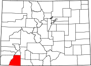
Ignacio, Colorado
Town of Ignacio, Colorado
FIPS code | 08-38535 | |
|---|---|---|
| GNIS feature ID | 184487 | |
| Website | Town of Ignacio | |
The Town of Ignacio (
2020 United States Census.[5] It is the headquarters of the Southern Ute Indian Reservation
.
Geography
Ignacio is located at 37°7′0″N 107°38′6″W / 37.11667°N 107.63500°W (37.116773, -107.634864).[7]
According to the United States Census Bureau, the town has a total area of 0.273 square miles (0.71 km2), all of it land.
Demographics
| Census | Pop. | Note | %± |
|---|---|---|---|
| 1920 | 290 | — | |
| 1930 | 464 | 60.0% | |
| 1940 | 555 | 19.6% | |
| 1950 | 526 | −5.2% | |
| 1960 | 609 | 15.8% | |
| 1970 | 613 | 0.7% | |
| 1980 | 667 | 8.8% | |
| 1990 | 720 | 7.9% | |
| 2000 | 669 | −7.1% | |
| 2010 | 697 | 4.2% | |
| 2020 | 852 | 22.2% | |
| U.S. Decennial Census[8] | |||
See also
- Ben Nighthorse Campbell
- Old Spanish National Historic Trail
- Southern Ute Cultural Center and Museum
References
- ^ a b "Active Colorado Municipalities". State of Colorado, Department of Local Affairs. Archived from the original on December 12, 2009. Retrieved September 1, 2007.
- ^ "Colorado Municipal Incorporations". State of Colorado, Department of Personnel & Administration, Colorado State Archives. December 1, 2004. Retrieved September 2, 2007.
- ^ "2019 U.S. Gazetteer Files". United States Census Bureau. Retrieved July 1, 2020.
- ^ "US Board on Geographic Names". United States Geological Survey. October 25, 2007. Retrieved January 31, 2008.
- ^ a b United States Census Bureau. "Ignacio town; Colorado". Retrieved April 22, 2023.
- ^ "ZIP Code Lookup". United States Postal Service. Archived from the original (JavaScript/HTML) on November 4, 2010. Retrieved October 13, 2007.
- ^ "US Gazetteer files: 2010, 2000, and 1990". United States Census Bureau. February 12, 2011. Retrieved April 23, 2011.
- ^ "Census of Population and Housing". Census.gov. Retrieved June 4, 2015.

