
Jayuya, Puerto Rico
Jayuya
Municipio Autónomo de Jayuya | ||
|---|---|---|
Town and Municipality | ||
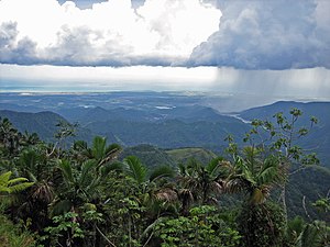
 Lush vegetation and mountains in Jayuya | ||
|
Commonwealth | ||
| Founded | 1911 | |
| Barrios | ||
| Government | ||
| • Mayor | AST) | |
| ZIP Code | 00664 | |
| Area code | 787/939 | |
| Major routes | ||
Jayuya (Spanish pronunciation:
Named after the Taíno tribal leader, Hayuya, Jayuya is known for its skilled wood carvers. Among its monuments are the statue of Nemesio Canales and the bust of Hayuya, both by the Puerto Rican sculptor Tomás Batista.
History
The town of Jayuya was founded in 1911, but history traces non-indigenous settlers living in the region as far back as 1878. At that time, a small community was established there, separated from the larger cities of the coasts with little to no communication. Near the end of the 19th century, the town focused on the production of coffee, which greatly boosted the local economy.
In 1911, the town was officially declared a municipality with a population of more than 9,000.
In 1950, the town was the setting of the

When Hurricane Maria hit Puerto Rico in September 2017, the people of Jayuya had to resort to collecting spring water.[5] Immediately following the hurricane, rescue and restoration efforts began by community members who gathered at the local high school.[6] Most wooden structures were destroyed.[7]
Geography
Jayuya is located in the center of the island of Puerto Rico, in a valley in the middle of the
The town's total area is estimated at 39.4 square miles (102.05 km2)[
Barrios

Like all municipalities of Puerto Rico, Jayuya is subdivided into barrios. The municipal buildings, central square and large Catholic church are located in the center of the municipality, in a barrio referred to as "el pueblo".[9][10][11][12]
Sectors
Barrios (which are, in contemporary times, roughly comparable to
Special Communities
Comunidades Especiales de Puerto Rico (Special Communities of Puerto Rico) are marginalized communities whose citizens are experiencing a certain amount of social exclusion. A map shows these communities occur in nearly every municipality of the commonwealth. Of the 742 places that were on the list in 2014, the following barrios, communities, sectors, or neighborhoods were in Jayuya: Gripiñas, Puerto Plata, Saliente, Salientito, Las Arenas, Comunidad Mario Canals (Sector El Salto), Comunidad Márquez, Hoyo Frío, Sector El Nudo, Santa Clara, Sector San Felipe, and Sector Las Casitas in Vista Alegre.[18][19]
Climate
As in most municipalities located in the mountain region, the climate is mostly cool with temperatures in the 80 to 70 °F (27 to 21 °C) range. However, they are known to go as low as 50 or 60 °F (10 or 16 °C) during some winters.
Demographics
| Census | Pop. | Note | %± |
|---|---|---|---|
| 1920 | 12,463 | — | |
| 1930 | 12,223 | −1.9% | |
| 1940 | 14,589 | 19.4% | |
| 1950 | 15,113 | 3.6% | |
| 1960 | 14,633 | −3.2% | |
| 1970 | 13,588 | −7.1% | |
| 1980 | 14,722 | 8.3% | |
| 1990 | 15,527 | 5.5% | |
| 2000 | 17,318 | 11.5% | |
| 2010 | 16,642 | −3.9% | |
| 2020 | 14,779 | −11.2% | |
| U.S. Decennial Census[20] 1920–1930[21] 1930–1950[22] 1960–2000[23] 2010[11] 2020[24] | |||

Festivals and events
Jayuya celebrates its
Other festivals and events celebrated in Jayuya include:
- Three Kings Festival- January
- Jíbaro Tomato Festival- February
- National Indigenous Festival- November
- La Monserrate Marathon- September
Tourism
Due to its location, Jayuya is usually mentioned as the obligatory municipality to visit when visiting the center of the island of
In the outskirts of the city, tourists can visit the

Jayuya is home to the first aerostat in Puerto Rico and one of the world's largest. It is located in barrio Mameyes, at 3,200 feet above sea level. When the aerostat lifts, it reaches 3,500 feet where it has a panoramic view of 360 degrees.[30]
Coffee production can be seen at Hacienda San Pedro located in Jayuya.[31]
Economy
Agriculture
Jayuya's economy has always depended greatly on agriculture. Products like coffee, tomato, and other vegetables are produced and distributed in the region. Livestock is another part of the city's economy.
Industry
In the middle of the 20th century, several manufacturing industries established in Jayuya, aiming to revitalize the economy as well as provide work for the residents. Some of the companies currently in the city are
Government
Like all municipalities in
The city belongs to the
Transportation
There are 34 bridges in Jayuya.[34]
Education
As all other municipalities in the island, Jayuya is part of the Puerto Rico Department of Education. It has several elementary schools distributed throughout the city's barrios. However, there's currently only one public high school, Josefina León Zayas High School, located in the city's downtown. The high school is LEED certified, for having a green-building design.[35]
The Metropolitan University, a private institution, has a campus in the municipality's downtown area.
Former mayors
- 1883 Julio Grau Battle – District Commissioner
- 1911–16 Rosario Canales
- 1916–20 Juan de Jesús López
- 1920–24 Ramón B. Marrero
- 1928 José Rivera Aponte (3 months)
- 1928–36 Jesús Dávila Rodríguez
- 1936–40 Vicente Santiago Reyes – Coalition Republican-Socialist
- 1940–44 Juan Oliver Frau PPD
- 1944 Mario Canales Torresola PPD (intern)
- 1944–48 Manuel Diversé PPD
- 1948–52 Ramón de Jesús Soto PPD
- 1952–68 Adrián Torres Torres PPD
- 1968–72 Rafael A. Ríos Delgado PNP
- 1972–76 José D. "Lolo" Castro González PPD
- 1976–84 Antonio Reyes Santiago PNP
- 1984–92 Venancio A. Tejedor León PPD
- 1992–96 José A. Rivera Rodríguez PNP
- 1996 -Jorge L. González Otero(PPD)
Additional information
- July 11, 1883 – The first parish was established
- March 9, 1911 – Municipality was established
- Mayte Vega Torres – National Winner Walker, athlete
Symbols
The municipio has an official flag and coat of arms.[36]
Flag
The flag is rectangular in shape and derives its symbolism from the coat of arms. It symbolizes the spirit of people proud of their
Coat of arms
Jayuya's coat of arms consists of a shield with a three tower crown above, which is standard for municipalities. Inside the shield, centered at the top, a
Gallery
-
 Puerto Rico's south shore, from the mountains of Jayuya, taken from Highway 143
 -
 School damaged by Hurricane María in 2017
 -
 Mountain in Jayuya
 -
 Hacienda Gripiñas in Jayuya
 -
 Cemi Museum in Coabey


See also
- List of Puerto Ricans
- History of Puerto Rico
- Did you know-Puerto Rico?
References
- ^ "PUERTO RICO: 2020 Census". The United States Census Bureau. Archived from the original on August 26, 2021. Retrieved August 25, 2021.
- ^ "Race and Ethnicity in the United States: 2010 Census and 2020 Census". Archived from the original on August 15, 2021. Retrieved September 19, 2021.
- ^ Jayuya... El Pueblo de Los Tres Picachos Archived September 25, 2012, at the Wayback Machine – Retrieved September 24, 2012
- ^ Mi pueblo del tomate, Jayuya Archived July 27, 2013, at the Wayback Machine – Retrieved September 24, 2012
- ^ Baez, Alvin (October 18, 2017). "The search for water in Puerto Rico". Reuters. Archived from the original on January 15, 2019. Retrieved January 15, 2019.
- ^ "Save our Souls: a window into Puerto Rico post-Maria realities". CONFLUENCE magazine. Archived from the original on January 18, 2022. Retrieved January 18, 2022.
- ^ "María, un nombre que no vamos a olvidar. Aislados en Jayuya" [Maria, a name we will never forget. Isolated in Jayuya]. El Nuevo Día (in Spanish). June 13, 2019. Archived from the original on September 11, 2022. Retrieved September 11, 2022.
- ^ a b "Jayuya Municipality". enciclopediapr.org. Fundación Puertorriqueña de las Humanidades (FPH). Archived from the original on August 23, 2019. Retrieved March 20, 2019.
- ^ Picó, Rafael; Buitrago de Santiago, Zayda; Berrios, Hector H. Nueva geografía de Puerto Rico: física, económica, y social, por Rafael Picó. Con la colaboración de Zayda Buitrago de Santiago y Héctor H. Berrios. San Juan Editorial Universitaria, Universidad de Puerto Rico,1969. Archived from the original on December 26, 2018. Retrieved January 4, 2019.
- ISBN 978-1-4766-0447-3. Retrieved December 25, 2018.
- ^ a b Puerto Rico:2010:population and housing unit counts.pdf (PDF). U.S. Dept. of Commerce Economics and Statistics Administration U.S. Census Bureau. 2010. Archived (PDF) from the original on February 20, 2017. Retrieved January 4, 2019.
- ^ "Map of Jayuya at the Wayback Machine" (PDF). Archived from the original (PDF) on March 24, 2018. Retrieved December 29, 2018.
- ^ "US Census Barrio-Pueblo definition". factfinder.com. US Census. Archived from the original on May 13, 2017. Retrieved January 5, 2019.
- ^ "P.L. 94-171 VTD/SLD Reference Map (2010 Census): Jayuya Municipio, PR" (PDF). www2.census.gov. U.S. DEPARTMENT OF COMMERCE Economics and Statistics Administration U.S. Census Bureau. Archived (PDF) from the original on August 23, 2020. Retrieved August 22, 2020.
- ^ "Agencia: Oficina del Coordinador General para el Financiamiento Socioeconómico y la Autogestión (Proposed 2016 Budget)". Puerto Rico Budgets (in Spanish). Archived from the original on June 28, 2019. Retrieved June 28, 2019.
- ISBN 978-0-9820806-1-0
- ^ "Leyes del 2001". Lex Juris Puerto Rico (in Spanish). Archived from the original on September 14, 2018. Retrieved June 24, 2020.
- ISBN 978-0-9820806-1-0
- ^ "Comunidades Especiales de Puerto Rico" (in Spanish). August 8, 2011. Archived from the original on June 24, 2019. Retrieved June 24, 2019.
- ^ "U.S. Decennial Census". United States Census Bureau. Archived from the original on February 13, 2020. Retrieved September 21, 2017.
- ^ "Table 3-Population of Municipalities: 1930 1920 and 1910" (PDF). United States Census Bureau. Archived (PDF) from the original on August 17, 2017. Retrieved September 21, 2017.
- ^ "Table 4-Area and Population of Municipalities Urban and Rural: 1930 to 1950" (PDF). United States Census Bureau. Archived (PDF) from the original on August 30, 2015. Retrieved September 21, 2014.
- ^ "Table 2 Population and Housing Units: 1960 to 2000" (PDF). United States Census Bureau. Archived (PDF) from the original on July 24, 2017. Retrieved September 21, 2017.
- ^ "PUERTO RICO: 2020 Census". The United States Census Bureau. Archived from the original on August 26, 2021. Retrieved August 25, 2021.
- ^ "Population and Housing Unit Estimates". United States Census Bureau. Archived from the original on December 18, 2014. Retrieved September 21, 2017.
- ^ "Puerto Rico Festivales, Eventos y Actividades en Puerto Rico". Puerto Rico Hoteles y Paradores (in Spanish). Archived from the original on February 26, 2020. Retrieved July 17, 2020.
- ^ "Fiestas Patronales en honor a la Virgen de la Monserrate". sondeaquiprnet. El Gobierno Municipal de Jayuya. Archived from the original on July 3, 2022. Retrieved August 14, 2023.
- ^ "Cemi Museum". Atlas Obscura. Archived from the original on May 10, 2019. Retrieved June 15, 2019.
- ^ "From The Trenches – Off the Grid – La Piedra Escrita". archive.archaeology.org. Archived from the original on November 5, 2019. Retrieved November 5, 2019.
- ^ "Alcalde de Jayuya dice recuperará inversión del globo a tres años". April 5, 2017. Archived from the original on July 14, 2017. Retrieved July 16, 2017.
- ^ Rivera, Edwin (November 6, 2012). "Hacienda San Pedro – Jayuya Puerto Rico". Archived from the original on November 8, 2019. Retrieved June 24, 2019 – via YouTube.
- ^ Irizarry Álvarez, Femmy (January 6, 2019). "Comenzarán trabajos del puente sobre río Viví en Utuado". Primera Hora (in Spanish). Archived from the original on February 19, 2019. Retrieved January 7, 2019.
- ^ Elecciones Generales 2012: Escrutinio General Archived January 15, 2013, at the Wayback Machine on CEEPUR
- ^ "Jayuya Bridges". National Bridge Inventory Data. US Dept. of Transportation. Archived from the original on February 21, 2019. Retrieved February 20, 2019.
- ^ "JOSEFINA LEÓN ZAYAS HS". ROSSILUGO. December 16, 2021. Archived from the original on January 18, 2022. Retrieved January 18, 2022.
- ^ "Ley Núm. 70 de 2006 -Ley para disponer la oficialidad de la bandera y el escudo de los setenta y ocho (78) municipios". LexJuris de Puerto Rico (in Spanish). Archived from the original on January 20, 2021. Retrieved June 15, 2021.
- ^ a b "JAYUYA". LexJuris (Leyes y Jurisprudencia) de Puerto Rico (in Spanish). February 19, 2020. Archived from the original on February 19, 2020. Retrieved September 17, 2020.
Further reading
- Mapa de municipios y barrios - Jayuya - Memoria Núm. 68 (PDF). University of Puerto Rico: Estado Libre Asociado de Puerto Rico, Oficina del Gobernador, Junta de Planificacion, Santurce, Puerto Rico. 1955.
- Historia, imagen, y sentir de un pueblo: Jayuya – Aura Pierluissi de Rodríguez
- En busca de mis ángeles – Iris de Jesus
- Worker in the Cane – Sidney Mintz
- Tiempos revueltos – Vionette G. Negretti
External links
- Puerto Rico Government Directory – Jayuya
- 191 historical images of Jayuya on the Arts & Culture project site by Google
Places adjacent to Jayuya, Puerto Rico | ||||||||||||||||
|---|---|---|---|---|---|---|---|---|---|---|---|---|---|---|---|---|
| ||||||||||||||||