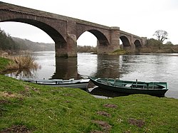
Ladykirk and Norham Bridge
Ladykirk and Norham Bridge | |
|---|---|
 | |
| Coordinates | 55°43′08″N 2°10′34″W / 55.719°N 2.176°W |
| Carries | Road traffic (single carriageway) |
| Crosses | River Tweed |
| Locale | Norham in Northumberland, England/ Ladykirk, Borders, Scotland |
| Characteristics | |
| Material | Stone |
| No. of spans | 4 |
| History | |
| Designer | Thomas Codrington and Cuthbert A. Brereton |
| Construction start | 1885 |
| Construction end | 1887 |
| Statistics | |
| Toll | No |
| Location | |
 | |
The Ladykirk and Norham Bridge connects
Earlier bridges
The previous bridge was a timber trestle built between 1838 and 1839 by J. Blackmore.[1][2] The bridge was funded by subscribers purchasing shares; David Robertson, 1st Baron Marjoribanks paid £3000, and ten others paid £500 each.[3]
This bridge used curved ribs eight planks deep at the ends and three planks deep in the middle, where each individual plank is 6 inches (150 mm) deep.[4] These were used to create two arches, each of 190 feet (58 m) span and 17 feet (5.2 m) rise, each arch was supported by two trusses.[4] The planks were 18 feet (5.5 m) long, and no piece of timber in the bridge was longer than 28 feet (8.5 m).[4] The roadway was 18 feet (5.5 m) wide.[4] The entire bridge was restored in 1852, with the exception of the stone piers.[3]
History
Construction of the present stone bridge lasted from 1885 to 1887.[1] The bridge is listed at grade II by English Heritage and at category B by Historic Scotland.[1][5]
It was designed by Thomas Codrington and Cuthbert A. Brereton for the Tweed Bridges Trust.[5]
Design
It is a late stone road
The bridge uses dressed-stone for the arch rings, and has coursed-rubble spandrels and wing walls.[6] It is built from red sandstone, and faced with ashlar dressings.[1] The spandrels are hollow to reduce the load on the arches, an innovation by Thomas Telford.[1][7]
The bridge carries the B6470 public road between the villages of Ladykirk in Scotland and Norham in England.[1] It is just downstream from Canny Island, a river island in the Tweed.[8]

References
- ^ a b c d e f "Ladykirk And Norham Bridge". rcahms.gov.uk. Retrieved 9 September 2014.
- ^ "Ladykirk and Norham Bridge". bridgesonthetyne.co.uk. Retrieved 10 September 2014.
- ^ a b Report of the Commissioners for Inquiring into Matters Relating to Public Roads in Scotland. Murray and Gibb. 1859. p. 132.
- ^ a b c d Warr, George Finden (1851). Dynamics, Construction of Machinery, Equilibrium of Structures and the Strength of Materials. Robert Baldwin. pp. 176–177.
- ^ a b c d "Ladykirk and Norham Bridge". sine.ncl.ac.uk. Archived from the original on 17 July 2012. Retrieved 9 September 2014.
- ^ a b "Historic Border Bridges". ice.org.uk. Retrieved 10 September 2014.
- ^ "Ashford Carbonell Bridge". engineering-timelines.com. Archived from the original on 2 April 2015. Retrieved 10 September 2014.
- ^ Google (9 September 2014). "Ladykirk and Norham Bridge" (Map). Google Maps. Google. Retrieved 9 September 2014.
