
Livermore Falls, Maine
Livermore Falls, Maine | |
|---|---|
2020) | |
| • Total | 3,060 |
| • Density | 60.2/sq mi (23.2/km2) |
| ZIP Code | 04254 |
| Area code | 207 |
| Website | lfme.org |

Livermore Falls is a
History
The area was once part of the
In the early 19th century, the region was predominantly farmland, with apple orchards and dairies supplying markets at
-
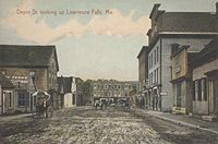 Depot Street in 1909
 -
 Third Bridge in 1909
 -
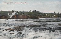 Umbagog Mills in 1909


Geography
According to the United States Census Bureau, the town has a total area of 20.42 square miles (52.89 km2), of which 19.68 square miles (50.97 km2) is land and 0.74 square miles (1.92 km2) is water.[1] Livermore Falls is drained by the Androscoggin River.
Climate
This
| Climate data for Livermore Falls, Maine, 1991–2020 normals, extremes 2000–present | |||||||||||||
|---|---|---|---|---|---|---|---|---|---|---|---|---|---|
| Month | Jan | Feb | Mar | Apr | May | Jun | Jul | Aug | Sep | Oct | Nov | Dec | Year |
| Record high °F (°C) | 61 (16) |
62 (17) |
82 (28) |
91 (33) |
93 (34) |
99 (37) |
101 (38) |
101 (38) |
100 (38) |
84 (29) |
76 (24) |
64 (18) |
101 (38) |
| Mean maximum °F (°C) | 49.7 (9.8) |
50.2 (10.1) |
58.3 (14.6) |
75.6 (24.2) |
86.8 (30.4) |
89.1 (31.7) |
91.1 (32.8) |
89.3 (31.8) |
87.0 (30.6) |
75.4 (24.1) |
65.0 (18.3) |
53.4 (11.9) |
93.1 (33.9) |
| Mean daily maximum °F (°C) | 27.9 (−2.3) |
30.7 (−0.7) |
39.4 (4.1) |
52.6 (11.4) |
65.8 (18.8) |
74.4 (23.6) |
79.9 (26.6) |
78.7 (25.9) |
70.8 (21.6) |
57.6 (14.2) |
45.3 (7.4) |
33.6 (0.9) |
54.7 (12.6) |
| Daily mean °F (°C) | 17.0 (−8.3) |
18.5 (−7.5) |
28.2 (−2.1) |
41.2 (5.1) |
53.4 (11.9) |
62.3 (16.8) |
68.2 (20.1) |
66.1 (18.9) |
58.0 (14.4) |
46.1 (7.8) |
34.8 (1.6) |
24.1 (−4.4) |
43.2 (6.2) |
| Mean daily minimum °F (°C) | 6.1 (−14.4) |
6.3 (−14.3) |
16.9 (−8.4) |
29.7 (−1.3) |
41.1 (5.1) |
50.3 (10.2) |
56.5 (13.6) |
53.6 (12.0) |
45.1 (7.3) |
34.7 (1.5) |
24.4 (−4.2) |
14.6 (−9.7) |
31.6 (−0.2) |
| Mean minimum °F (°C) | −13.6 (−25.3) |
−11.1 (−23.9) |
−4.6 (−20.3) |
17.3 (−8.2) |
27.7 (−2.4) |
37.9 (3.3) |
45.7 (7.6) |
42.1 (5.6) |
30.5 (−0.8) |
22.0 (−5.6) |
10.3 (−12.1) |
−4.8 (−20.4) |
−17.7 (−27.6) |
| Record low °F (°C) | −27 (−33) |
−23 (−31) |
−20 (−29) |
9 (−13) |
23 (−5) |
28 (−2) |
39 (4) |
36 (2) |
22 (−6) |
14 (−10) |
−1 (−18) |
−26 (−32) |
−27 (−33) |
| Average precipitation inches (mm) | 3.36 (85) |
3.05 (77) |
3.69 (94) |
4.06 (103) |
3.42 (87) |
4.48 (114) |
3.93 (100) |
3.78 (96) |
3.50 (89) |
5.18 (132) |
4.29 (109) |
4.42 (112) |
47.16 (1,198) |
| Average snowfall inches (cm) | 19.8 (50) |
26.6 (68) |
15.9 (40) |
3.2 (8.1) |
0.3 (0.76) |
0.0 (0.0) |
0.0 (0.0) |
0.0 (0.0) |
0.0 (0.0) |
0.4 (1.0) |
4.7 (12) |
20.3 (52) |
91.2 (231.86) |
| Average extreme snow depth inches (cm) | 17.5 (44) |
21.3 (54) |
18.9 (48) |
7.8 (20) |
0.3 (0.76) |
0.0 (0.0) |
0.0 (0.0) |
0.0 (0.0) |
0.0 (0.0) |
0.5 (1.3) |
3.5 (8.9) |
12.4 (31) |
24.3 (62) |
| Average precipitation days (≥ 0.01 in) | 9.7 | 9.0 | 8.6 | 10.9 | 13.3 | 13.7 | 12.2 | 11.3 | 8.8 | 12.4 | 10.6 | 11.4 | 131.9 |
| Average snowy days (≥ 0.1 in) | 7.7 | 7.3 | 4.8 | 2.2 | 0.1 | 0.0 | 0.0 | 0.0 | 0.0 | 0.2 | 2.6 | 6.7 | 31.6 |
| Source 1: NOAA[7] | |||||||||||||
| Source 2: National Weather Service (mean maxima/minima, snow depth, 2006–2020)[8] | |||||||||||||
Demographics
| Census | Pop. | Note | %± |
|---|---|---|---|
| 1890 | 963 | — | |
| 1930 | 3,148 | — | |
| 1940 | 3,190 | 1.3% | |
| 1950 | 3,359 | 5.3% | |
| 1960 | 3,343 | −0.5% | |
| 1970 | 3,450 | 3.2% | |
| 1980 | 3,572 | 3.5% | |
| 1990 | 3,455 | −3.3% | |
| 2000 | 3,227 | −6.6% | |
| 2010 | 3,187 | −1.2% | |
| 2020 | 3,060 | −4.0% | |
| U.S. Decennial Census[9] | |||
2010 census
As of the
There were 1,316 households, of which 33.9% had children under the age of 18 living with them, 40.8% were married couples living together, 14.3% had a female householder with no husband present, 6.4% had a male householder with no wife present, and 38.5% were non-families. 31.1% of all households were made up of individuals, and 12.7% had someone living alone who was 65 years of age or older. The average household size was 2.41 and the average family size was 2.95.
The median age in the town was 38.1 years. 25.8% of residents were under the age of 18; 7.8% were between the ages of 18 and 24; 25.6% were from 25 to 44; 25.6% were from 45 to 64; and 15.2% were 65 years of age or older. The gender makeup of the town was 49.2% male and 50.8% female.
2000 census
As of the
There were 1,322 households, out of which 33.0% had children under the age of 18 living with them, 44.8% were married couples living together, 13.2% had a female householder with no husband present, and 36.8% were non-families. Of all households, 30.8% were made up of individuals, and 12.9% had someone living alone who was 65 years of age or older. The average household size was 2.39 and the average family size was 2.95.
In the town, the population was spread out, with 27.8% under the age of 18, 7.6% from 18 to 24, 27.4% from 25 to 44, 21.8% from 45 to 64, and 15.3% who were 65 years of age or older. The median age was 36 years. For every 100 females, there were 96.1 males. For every 100 females age 18 and over, there were 90.4 males.
The median income for a household in the town was $30,102, and the median income for a family was $33,354. Males had a median income of $30,139 versus $22,381 for females. The
Voter registration
| Voter Registration and Party Enrollment as of June 2014[12] | |||||
|---|---|---|---|---|---|
| Party | Total Voters | Percentage | |||
| Unenrolled | 744 | 40.2% | |||
| Democratic | 646 | 34.9% | |||
| Republican | 351 | 19.0% | |||
| Green Independent | 109 | 5.9% | |||
| Total | 1,850 | 100% | |||
Transportation

The Bowman Field airport is located four nautical miles (5 mi, 7 km) southeast of the central business district of Livermore Falls.[13]
Education
Livermore Falls is part of Maine School Administrative District #36. MSAD 36 was renamed RSU 36 in 2009. The three schools in the district are Livermore Elementary School, Livermore Falls Middle School and Livermore Falls High School.
In 2010 RSU 36 consolidated with Jay Schools to form RSU 73 encompassing Jay, Livermore and Livermore Falls. Jay High School and Livermore Falls High School were renamed Spruce Mountain High School North and South campuses respectively. The Tigers and Andies mascots were replaced by the Spruce Mountain Phoenix. Livermore Falls Middle School was closed in the summer of 2011 and the students and faculty were incorporated into the new Spruce Mountain Middle School located at the former Jay Middle School building. Plans to unite the two high schools under one roof are being laid with a number of options available, a) Extend the current North Campus facility to accommodate the students and staff from the South Campus, b) Install portable buildings to increase the space at North Campus to facilitate the union of the high schools, c) relocate the Spruce Mountain Middle School to the South Campus and move the South Campus High School to the North Campus. The vote to allow the raising of a bond to enable the building of the planned extension failed in early 2012 and the other options are being examined.
Notable people
- Kevin Bailey, Texas politician
- Louise Bogan, poet, critic
- Herbert Elijah Wadsworth, businessman
References
- ^ a b "US Gazetteer files 2010". United States Census Bureau. Retrieved December 16, 2012.
- ^ "Census - Geography Profile: Livermore Falls town, Androscoggin County, Maine". Retrieved January 15, 2022.
- ^ Coolidge, Austin J.; John B. Mansfield (1859). A History and Description of New England. Boston, Massachusetts: A.J. Coolidge. pp. 111–112.
coolidge mansfield history description new england 1859.
- ^ George J. Varney, "History of Durham, East Livermore & Greene, Maine" (1886)
- ^ "History of Livermore Falls, Maine". Archived from the original on February 16, 2015. Retrieved November 19, 2010.
- ^ Climate Summary for Livermore Falls, Maine
- ^ "U.S. Climate Normals Quick Access – Station: Livermore Falls 1 E, ME". National Oceanic and Atmospheric Administration. Retrieved September 4, 2023.
- ^ "NOAA Online Weather Data – NWS Gray". National Weather Service. Retrieved September 4, 2023.
- ^ "Census of Population and Housing". Census.gov. Retrieved June 4, 2015.
- ^ "U.S. Census website". United States Census Bureau. Retrieved December 16, 2012.
- ^ "U.S. Census website". United States Census Bureau. Retrieved January 31, 2008.
- ^ "Maine voters by town and party registration". November 2013.
- PDF. Federal Aviation Administration. Effective 30 June 2011.
External links
- Town of Livermore Falls, Maine
- Treat Memorial Library
- Maine Genealogy: Livermore Falls, Androscoggin County, Maine
Municipalities and communities of Androscoggin County, Maine, United States | ||
|---|---|---|
| Cities |  | |
| Towns | ||
| CDPs | ||
Other communities | ||
| ||
| International | |
|---|---|
| National | |