Mzymta
This article needs additional citations for verification. (May 2020) |
| Mzymta River | |
|---|---|
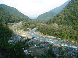
 Mzymta from Maidens' Eyewater waterfall | |
| Location | |
| Country | |
| Federal subject | |
| Physical characteristics | |
| Source | |
| • location | Greater Caucasus |
| • elevation | 2,980 m (9,780 ft) |
| Mouth | |
• location | Black Sea |
• coordinates | 43°24′57″N 39°55′25″E / 43.41583°N 39.92361°E |
• elevation | 0 m (0 ft) |
| Length | 89 km (55 mi)[1] |
| Basin size | 885 km2 (342 sq mi)[1] |
| Discharge | |
| • average | 45.6 m3/s (1,610 cu ft/s) (near mouth) |


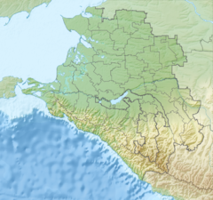
The Mzymta (Russian: Мзы́мта, Adyghe: Мэзмытӏэ, Mezmytha) is a river in Northwestern Caucasus, flowing through Mostovsky District and the city of Sochi (Adlersky City District) of Krasnodar Krai, Russia. The Mzymta is the largest river in Russia emptying into the Black Sea. It is 89 kilometres (55 mi) long with a watershed of 885 square kilometres (342 sq mi).[1] All the venues of the 2014 Winter Olympics were in the Mzymta Valley.
Geography
The source of the Mzymta is in
spring tides and rain freshets
.
The Mzymta is a floatable river, and the popular attraction is rafting. Krasnopolyanskaya hydroelectric power station has a reservoir with a daily streamflow regulation.
Average intensity of flow
- Krasnaya Polyana: 33.2 cubic metres per second (1,170 cu ft/s)
- Kepsh: 45.6 cubic metres per second (1,610 cu ft/s) (max 764 cubic metres per second (27,000 cu ft/s))
Major inflows
Inhabited localities
- Estosadok
- Krasnaya Polyana
- Chvizhepse
- Kepsha
- Monastyr
- Galitsyno
- Kazachy Brod
- Vysokoye
- Moldovka
- Adler
References
- ^ a b c Река Мзымта (in Russian). State Water Register of Russia. Retrieved 1 February 2014.


