
Obolon, Kyiv
Obolon
Оболонь | |
|---|---|
UTC+3 (EEST) | |
| Postal code | 04504, 04205, 04209, 04210, 04211, 04212, 04213, 04214 |
| Area code | +380 44 |
Obolon (Ukrainian: Оболонь [oboˈlɔnʲ] ⓘ) is a historical locality which includes a residential area (masyv), along with an industrial park within the Ukraine's capital Kyiv that is located on its northern side, in an eponymous city district - the Obolonskyi District (until 2001 – Minskyi District).
In Ukrainian language the word obolon' (оболонь) means a 'low country near a river'[2] (floodplain) or 'flood-meadows' (Ukrainian: заплавні луки[3][4]).
As Obolon's land regularly used to flood by the
Geography
The suburb is located in the South of the Polesian Lowland, in the northern a part of Kyiv city's area.
The Dnieper, its bays, small rivers, ponds and lakes around Obolon were used as sources of sand for the height elevation for the further building construction, using the hydraulic fill technology.[5] Thus the Obolon landscape was significantly changed by people.
Obolon is isolated from other parts Kyiv city by the
.It borders the Opechen lakes system in the west, which was supposedly created on the place where the legendary Pochaina River used to be. In 2016 some historians revealed that the river continues to exist and is located in the vicinity of mentioned system of lakes.[6] The east boundary of the suburb is the Dnieper with its bays: the Sobache hyrlo (Dog's river mouth) and the Obolon bay (the former names the Starytsa, that can be translated as a former riverbed, or the Bratsky Staryk). There are Redkyne Lake (Ministerka) and the Verbliud (Camel) bay in the north of Obolon, which was created by the size expansion of Lukove Lake (Ulukovo) when soil from it was being taken. Verbne Lake[7] (Willow) and the Vovkuvata bay are in the south of the suburb.[8]
The closest suburbs to Obolon are Khutir Redky, Minskyi Masyv, Priorka, Petrivka belonging to the Obolonskyi District too and Kurenivka, Rybalskyi Ostriv belonging to the Podilskyi District of Kyiv.
By roads, the suburb is located:
- 10 km to the Kyiv city centre.
- 13 km to the city's central station - Kyiv-Pasazhyrskyi railway station.
- 16 km to Kyiv International Airport (Zhuliany)
- 43 km to the main city's airport - Boryspil International Airport.
There is Road P69 (Ukraine) (P69, Kyiv - Vyshhorod - Desna - Chernihiv) going through the western part of the suburb.
Historical map studies

The Ukrainian historian
On the Kyiv map of 1902 year created by city's
History
Early time
Around the chronicles Pochaina River, nowadays it is the Opechen lakes system, were found the Mesolithic and Zarubintsy culture archaeological sites.[11]
Remains of settlements the 1th BC - 2nd AD centuries and the 6th - 7th centuries were found in Obolon.[12]

The first who drew special attention to Obolon was the Ukrainian historian
Before the
At the time of Kievan Rus and the
After the
At the time of the
During the
In 1911 the Kurenivka civil aerodrome was opened on Obolon fields.
Soviet era
As a result of the Ukrainian–Soviet War (1917–1921) and the Polish–Soviet War (1919–1921) Kyiv City and its suburbs was finally captured by the Red Army.
In 1967 the development plan of Kyiv was approved, according to which residential areas would be constructed on wetlands on both sides of the Dnieper. Thus, using the hydraulic fill technology, а sand layer 4–5 metres in height was created above Obolon flood-meadows. In 1972 - 1980 the biggest housing estate of tower blocks in Kyiv was erected in Obolon.[17]
In 1975 a new
In 1972 - 1980 there is the biggest Kyiv's housing estate of 9 and 16 storey tower blocks erected in Obolon. The estate architects were Grygory Slutsky, Yurii Paskevych, Leonid Filenko, M. I. Kulchynsky, Z. G. Klebnikova and I. G. Verymovska. It is locally famous for its honeycomb-like neighborhood planned development with high-rising multi-story apartment complexes (see Public housing).
In 1980 in Obolon was officially opened the Obolon beer brewing company commemorated to the 1980 Summer Olympics.
Present construction

Since 1992 the modern
Gallery
-
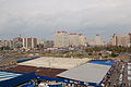
 Apartment complexes seen from the river
 -
 The embankment
 -
 Minska ploshcha cityscape
 -
 Obolon beer factory


External links
References
- ^ "Kyiv, Encyclopaedic reference book". Kyiv. 1981
Ukrainian: «Київ. Енциклопедичний довідник» УРЕ, Київ-1981 - ^ Ukrainian-English translation for "Оболонь" // English-Ukrainian dictionary, 2009, "Perun" publishing house // ABBYY Lingvo-Online
Ukrainian: Українсько-англійський переклад «Оболонь» - ABBYY Lingvo-Online, Англо-український словник під загальною редакцією В'ячеслава Бусела, 2009, ВТФ "Перун", 250 тис. слів і словосполучень. - ^ Meaning and Interpretation "Obolon" // Great Dictionary of Modern Ukrainian Language, 2005 "Perun" publishing house // ABBYY Lingvo-Online
Ukrainian: Значення та тлумачення «Оболонь» - ABBYY Lingvo-Online, Великий тлумачний словник сучасної української мови. Видавництво "Перун", 2005. 250 тис. слів та словосполучень. - ^ OBOLON // Academic Dictionary of the Ukrainian language
Ukrainian: ОБОЛОНЬ – Академічний тлумачний словник української мови - ^ The sand alluvium in Obolon, 1970. // Interesting Obolon
Russian: Намыв песка на Оболони, 1970-е годы. // Интересная Оболонь - ^ Spivak, T. The newly acquired Pochaina. Lb.ua. 19 May 2016
- ^ Verbne Lake // Interesting Obolon
Russian: Озеро Вербное // Интересная Оболонь - ^ Obolon in 1850 - 1917 // Kyiv's islands and coastal terrains on the Dnieper - the view through the ages I. Y. Parnikoza
Ukrainian: Оболонь в 1850 – 1917 р. // Київські острови та прибережні урочища на Дніпрі – погляд крізь віки // Парнікоза І.Ю. - ^ The historical maps of Kyiv
Ukrainian: Історичні карти Києва - ^ The map of Kyiv, 1902
Russian: Планъ города Кіева, 1902 года - ^ At the time of ancient cultures (10th - 1st millenniums BC) // Kyiv's islands and coastal terrains on the Dnieper - the view through the ages I. Y. Parnikoza
Ukrainian: В часи прадавніх культур (10-1 тис. до н.е.) // Київські острови та прибережні урочища на Дніпрі – погляд крізь віки // Парнікоза І.Ю. - : Київ. Короткий топонімічний довідник
- ^ Turvont Kybalchych // Encyclopedia of Modern Ukraine
Ukrainian: Кибальчич Турвонт Венедиктович // Енциклопедія Сучасної України - ^ The Secrets of Ancient Obolon // Hanna Shovkoplias
Ukrainian: Шовкопляс Г.М. // Таємниці Давньої Оболоні - ^ The origin, distribution and social order of the Slavs in VI - IX centuries. - History of Ukraine // Online study materials
Ukrainian: Походження, розселення та устрій слов'ян у VI - IX ст. - Історія України - Навчальні матеріали онлайн - Magdeburg Law in Kyiv: Розділ VI. Делімарський Р. Маґдебургзьке право у Києві
Ukrainian - NASU Institute of History of Ukraine: Світлана Архипова // Динаміка розширення меж м. Києва в XX ст.: Історико-географічний аспект.
Ukrainian - ^ The history of Obolon // The centralised library system of the Obolon Raion
Ukrainian: Історія Оболоні // Централізована біліотечна система Оболонського району
| Neighborhoods1 |
|  |
|---|---|---|
| Lakes, rivers, bays |
| |
| ||