
Ortler
| Ortler | |
|---|---|
Alpine mountains above 3000 m | |
| Coordinates | 46°30′32″N 10°32′42″E / 46.50889°N 10.54500°E |
| Geography | |
 Ortler Location in the Alps | |
| Location | South Tyrol, Italy |
| Parent range | Ortler Alps |
| Climbing | |
| First ascent | 27 September 1804 |
| Easiest route | North ridge from the Payer house |
Ortler (German pronunciation:
Geography
The massive mountain is capped by a glacier on the northwest flank and has a long north ridge that ends at the village of Gomagoi and separates the valleys of
First ascent

The Ortler was first climbed by
Upon their return, the men were not believed on their words alone. Gebhard sent Pichler onto the mountain twice more, first in August 1805 with a flag that could be observed with a telescope from the valley, and again in September 1805 with a huge torch. Only after the torch had been seen burning at night was the accomplishment acknowledged. The route Pichler and his men (two brothers named Hell and an unnamed hunter from Langtaufers) took in 1805 was the currently still popular East ridge ("Hintergrat", literally "back-ridge") route. In 1834, at the age of 70, Pichler would make his fifth and final ascent, guiding Professor Karl Thurwieser to the top.
Notable other ascents and descents

The first time the Ortler was climbed via the easiest and currently normal route, the North ("Tabaretta") ridge, was more recently, in July 1865, as the approach is rather lengthy. In 1875 a hut was erected 3,029m high on the North ridge, to break up the climb in two steps. It was named the Payer house, after Julius von Payer, who had mapped the Ortler Alps between 1865–1868 and had climbed 50 of its peaks with Johann Pinggera as his guide.
The first ascent of the South ridge from the Hochjoch followed in 1875, two couloirs on the East face (the Minnigerode and Schück couloir) were opened in 1878-79 and the two steep Northeast ridges (Marlet and Rothböck ridge) were conquered in 1889 and 1909, respectively. Members of the Pinggera family were involved in most of these ascents.
The 1,200 m high ice route on the Ortler north face, longest in the Eastern Alps, was first climbed in June 1931 by Hans Ertl and Franz Schmid and the remote Southwest face in 1934. The North face was soloed first in 1963 by Dieter Drescher who had also added some first winter ascents to his name, including a traverse of Königspitze, Monte Zebrù, and Ortler in February 1975. On August 31, 1981, Reinhard Patscheider achieved the amazing feat of climbing the north faces of Königspitze, Zebrù and Ortler all in one day.
Extreme skiing started early in the Ortler mountains, with Heini Holzer descending the Schück couloir in 1971 and the Minnigerode couloir in 1975. On June 24, 1983, Andreas Orgler skied down the North face.
First World War

The Ortler Alps were one of the main battlegrounds between Austrian and Italian troops in the
See also
- List of Italian regions by highest point
- List of mountains of the Alps above 3000 m
References
- ^ Retrieved from the Swisstopo topographic maps. The key col is Passo di Fraéle (1,952 m).
- ^ "The famous triangle : Photos, Diagrams & Topos". SummitPost. Retrieved 13 April 2013.
- ^ "Ortler 3905m Meranerweg Pleisshorngrat von der Berglhütte Trafoi". Seilschaft.it. Retrieved 13 April 2013.
Sources and external links
- Sabine Holzknecht, Sulden und der Ortler, ″Alpin″ June 2004 (German article at the occasion of the 200-year anniversary of the first ascent)
- German article on the first ascent
- First World War pictures of the Ortler frontline
- View from the Ortler to the southeast
- Panoramic view from the northwest of the Ortler in winter
- Coolidge, William Augustus Brevoort (1911). . Encyclopædia Britannica. Vol. 20 (11th ed.). p. 341.
- . New International Encyclopedia. 1905.
Gallery
-
 Ortler ascent
 -
 Königspitze, Zebrù and Ortler from the south-east
 -
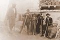 Mountaineers from Vienna at the Payer house on their way to climb the Ortler in July 1891.
 -
 Ortler glacier as seen from the Stelvio Pass to the west. Photo about 1900.
 -
 Obelisk at the Forte Weisser Knott on the Swiss-Italian border, with inscription describing the first ascent of the Ortler by Josef Pichler.


| Authority control databases: National |
|---|