
Musala
| Musala | |
|---|---|
| Мусала | |
Ultra | |
| Coordinates | 42°10′47″N 23°35′12″E / 42.17972°N 23.58667°E |
| Geography | |
 Musala Musala in Bulgaria | |
| Location | Sofia Region, Bulgaria |
| Parent range | Rila |
| Climbing | |
| Easiest route | Gondola lift from Borovets, then hike |
Musala (
With a topographic prominence of 2,473 metres (8,114 ft), Musala is also the 6th highest peak by topographic prominence in mainland Europe.[4] It is also the 3rd most topographically isolated major peak in Continental Europe.[5]
Musala is situated within the
A cosmic ray station was built on the peak in 1960 with cooperation from the Hungarian Academy of Science. The station conducted scientific experiments using a muon telescope. The station was destroyed by an electrical fire on October 29, 1983.[6]
With an average annual temperature of -2.2 °C, Musala is the coldest place in Bulgaria and the entire Balkan Peninsula.[
The next highest peaks in the vicinity of Musala are Malka (Little) Musala (2,902 metres (9,521 ft)) and Irechek (2,852 metres (9,357 ft)).
Climate
Musala has an alpine climate with long, cold winters and short, cool summers. Usually, through winter, the temperatures do not exceed the freezing point for months. Snow cover lasts for about 8–9 months. Through the summer, temperatures rarely go above 14-15C. The summer season only lasts for 2 months, and snowfalls are possible. For the period 1931–2013, the highest recorded temperature was 20.0 °C (68.0 °F), and the lowest - −31.2 °C (−24.2 °F). The average annual temperature is −2.5 °C (27.5 °F), which makes the peak the coldest place in Bulgaria.
| Climate data for Musala Peak (2000–2013) | |||||||||||||
|---|---|---|---|---|---|---|---|---|---|---|---|---|---|
| Month | Jan | Feb | Mar | Apr | May | Jun | Jul | Aug | Sep | Oct | Nov | Dec | Year |
| Record high °C (°F) | 7.0 (44.6) |
8.0 (46.4) |
12.1 (53.8) |
13.7 (56.7) |
12.6 (54.7) |
18.0 (64.4) |
20.0 (68.0) |
18.7 (65.7) |
16.4 (61.5) |
14.2 (57.6) |
9.6 (49.3) |
6.8 (44.2) |
20.0 (68.0) |
| Mean daily maximum °C (°F) | −8.2 (17.2) |
−7.6 (18.3) |
−5.6 (21.9) |
−1.2 (29.8) |
2.7 (36.9) |
7.1 (44.8) |
10.1 (50.2) |
10.2 (50.4) |
6.3 (43.3) |
2.2 (36.0) |
−1.8 (28.8) |
−6.1 (21.0) |
0.7 (33.3) |
| Daily mean °C (°F) | −11.0 (12.2) |
−10.6 (12.9) |
−8.6 (16.5) |
−4.1 (24.6) |
−0.1 (31.8) |
4.4 (39.9) |
6.9 (44.4) |
7.2 (45.0) |
3.4 (38.1) |
−0.6 (30.9) |
−4.4 (24.1) |
−8.6 (16.5) |
−2.1 (28.2) |
| Mean daily minimum °C (°F) | −13.8 (7.2) |
−13.6 (7.5) |
−11.6 (11.1) |
−7.0 (19.4) |
−3.1 (26.4) |
1.6 (34.9) |
3.7 (38.7) |
4.2 (39.6) |
0.5 (32.9) |
−3.1 (26.4) |
−6.9 (19.6) |
−11.0 (12.2) |
−4.9 (23.2) |
| Record low °C (°F) | −30.6 (−23.1) |
−29.8 (−21.6) |
−26.8 (−16.2) |
−20.6 (−5.1) |
−15.6 (3.9) |
−12 (10) |
−8 (18) |
−9.8 (14.4) |
−14 (7) |
−17.5 (0.5) |
−27.4 (−17.3) |
−31.2 (−24.2) |
−31.2 (−24.2) |
| Average precipitation mm (inches) | 126 (5.0) |
110 (4.3) |
130 (5.1) |
128 (5.0) |
119 (4.7) |
105 (4.1) |
80 (3.1) |
56 (2.2) |
47 (1.9) |
72 (2.8) |
88 (3.5) |
115 (4.5) |
1,176 (46.3) |
| Average rainy days | 1 | 0 | 0 | 0 | 4 | 8 | 9 | 7 | 6 | 3 | 1 | 0 | 39 |
| Average snowy days | 13 | 14 | 17 | 18 | 14 | 5 | 2 | 1 | 4 | 8 | 13 | 15 | 124 |
| Mean monthly sunshine hours | 114 | 112 | 140 | 127 | 168 | 181 | 250 | 250 | 182 | 169 | 128 | 104 | 1,925 |
| Source: Stringmeteo.com | |||||||||||||
| Climate data for Musala Peak, 1991-2020 (elevation 2925m) | |||||||||||||
|---|---|---|---|---|---|---|---|---|---|---|---|---|---|
| Month | Jan | Feb | Mar | Apr | May | Jun | Jul | Aug | Sep | Oct | Nov | Dec | Year |
| Record high °C (°F) | 7.2 (45.0) |
4.9 (40.8) |
6.5 (43.7) |
8.6 (47.5) |
13.0 (55.4) |
17.6 (63.7) |
19.8 (67.6) |
19.2 (66.6) |
17.9 (64.2) |
15.0 (59.0) |
11.0 (51.8) |
10.2 (50.4) |
19.8 (67.6) |
| Mean daily maximum °C (°F) | −6.7 (19.9) |
−7.0 (19.4) |
−5.1 (22.8) |
−1.9 (28.6) |
2.4 (36.3) |
6.6 (43.9) |
9.3 (48.7) |
9.7 (49.5) |
5.9 (42.6) |
2.7 (36.9) |
−1.5 (29.3) |
−5.3 (22.5) |
0.8 (33.4) |
| Daily mean °C (°F) | −9.7 (14.5) |
−10.0 (14.0) |
−8.2 (17.2) |
−4.8 (23.4) |
−0.2 (31.6) |
3.7 (38.7) |
6.0 (42.8) |
6.4 (43.5) |
2.6 (36.7) |
−0.3 (31.5) |
−4.3 (24.3) |
−8.1 (17.4) |
−2.2 (28.0) |
| Mean daily minimum °C (°F) | −12.5 (9.5) |
−12.9 (8.8) |
−11.1 (12.0) |
−7.4 (18.7) |
−2.5 (27.5) |
1.2 (34.2) |
3.3 (37.9) |
3.9 (39.0) |
0.2 (32.4) |
−2.7 (27.1) |
−6.8 (19.8) |
−10.8 (12.6) |
−4.8 (23.3) |
| Record low °C (°F) | −27.5 (−17.5) |
−31.6 (−24.9) |
−26.8 (−16.2) |
−22.5 (−8.5) |
−13.5 (7.7) |
−9.0 (15.8) |
−6.1 (21.0) |
−6.0 (21.2) |
−11.9 (10.6) |
−16.3 (2.7) |
−23.2 (−9.8) |
−24.9 (−12.8) |
−31.6 (−24.9) |
| Average precipitation mm (inches) | 75 (3.0) |
74 (2.9) |
95 (3.7) |
98 (3.9) |
88 (3.5) |
80 (3.1) |
72 (2.8) |
55 (2.2) |
48 (1.9) |
40 (1.6) |
40 (1.6) |
68 (2.7) |
833 (32.9) |
| Average precipitation days (≥ 1.0 mm) | 11 | 11 | 13 | 13 | 13 | 12 | 10 | 7 | 7 | 7 | 8 | 11 | 123 |
| Mean monthly sunshine hours | 126 | 119 | 142 | 134 | 159 | 170 | 228 | 241 | 185 | 165 | 124 | 106 | 1,899 |
| Source: NOAA[7] | |||||||||||||
Namesakes
Musala Glacier on Greenwich Island in the South Shetland Islands, Antarctica is named after Musala Peak.
Gallery
-
-
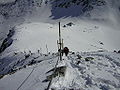 Hikers near the summit of Musala. The pyramid in the background is the Everest shelter
 -
 ThePirin Mountainscan be seen from Musala
 -
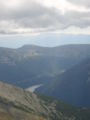
 The origin of the Maritsa River seen from Musala
 -
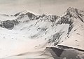
 Musala as seen from Yastrebets. The chalet Musala and the Everest shelter can be seen as well.


See also
- Rila
- Malyovitsa
- Rila National Park
- List of mountains in Bulgaria
- Geography of Bulgaria
- List of mountains of the Balkans
- List of European ultra-prominent peaks
- List of the highest European ultra-prominent peaks
- Most isolated major summits of Europe
- List of mountain ranges
- List of World Heritage Sites in Bulgaria
References
- ^ Известия на българското географско дружество, 1964 г. стр. 197.
- ^ Bŭlgarski ezik, Volume 19,Institut za bŭlgarski ezik (Bŭlgarska akademii͡a na naukite), 1969, str. 573.
- ^ "ГEOграфия'21, брой 5, 2007 г." www.prokarstterra.bas.bg. Retrieved 2023-06-09.
- ^ "Europe Ultra-Prominences". Peaklist. Retrieved 26 February 2015.
- ^ "Most Isolated Peak of Europe Countries - Peakbagger.com".
- .
- ^ a b "Musala Peak Climate Normals 1991-2020". National Oceanic and Atmospheric Administration. Retrieved August 29, 2023.
- "Мусала". Българска енциклопедия А-Я (in Bulgarian). БАН, Труд, Сирма. 2002. OCLC 163361648.
External links
- Musala – controllable web camera (in Bulgarian)
- Musala climb on youtube