
Pecos River
| Pecos River Río Pecos Río Natagés | |
|---|---|
 | |
 Map of the Pecos River watershed. | |
| Location | |
| Country | United States |
| State | Texas, New Mexico |
| Physical characteristics | |
| Source | Pecos Falls |
| • location | 29 mi (47 km) north of Pecos, New Mexico |
| • coordinates | 35°58′34″N 105°33′29″W / 35.97611°N 105.55806°W[1] |
| • elevation | 11,759 ft (3,584 m) |
| Mouth | Rio Grande |
• location | Seminole Canyon, Val Verde County, 37 mi (60 km) northwest of Del Rio, Texas |
• coordinates | 29°41′59″N 101°22′17″W / 29.69972°N 101.37139°W[1] |
• elevation | 1,115 ft (340 m) |
| Length | 926 mi (1,490 km)[2] |
| Basin size | 44,402 sq mi (115,000 km2)[2] |
| Discharge | |
| • location | IBWC station 08-4474.10 near Langtry, Texas[3] |
| • average | 265 cu ft/s (7.5 m3/s)[3] |
| • minimum | 42 cu ft/s (1.2 m3/s) |
| • maximum | 152,910 cu ft/s (4,330 m3/s) |
| Type | Wild, Recreational |
| Designated | June 6, 1990 |
The Pecos River (
The name "Pecos" derives from the
History
The river was the eastern territory of the Faraon (‘Pharaoh’) Apache Indians, a tribe of Apache, probably closely related to the Mescalero Apache, if not part of them. Their divisions were Ancavistis, Jacomis, Orejones, Carlanes, and Cuampes, but of these the Carlanes at least belonged to the Jicarillas. The river later played a large role in the exploration of Texas by the
Dams
Multiple dams have been built along the Pecos River. Santa Rosa Lake is 117 miles/188 km east of Albuquerque.[10] Sumner Lake, formed by the 1939 Sumner Dam, is located between Santa Rosa and Fort Sumner, NM.[11] Two dams are located north of Carlsbad, New Mexico, at Avalon Dam and Brantley Dam, to help irrigate about 25,000 acres (10,000 ha) as part of the Carlsbad reclamation project (established in 1906). Texas has also dammed the river at the Red Bluff Dam in the western part of that state to form the Red Bluff Reservoir. The portion of the reservoir that extends into New Mexico forms the lowest point in that state.
Wild and Scenic river
On June 6, 1990, 20.5 miles (33 km) of the Pecos River—from its
-
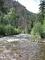 Pecos River between Terrerro and Pecos, New Mexico
 -
 The Pecos River flowing south of Grandfalls, Texas
 -
 Pecos River near the Rio Grande
 -
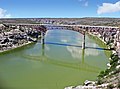 Pecos River Highway Bridge


Pecos River Flume

The Pecos River Flume is an aqueduct carrying irrigation water over the Pecos River. Construction took place from 1889 to 1890 and was part of the Pecos River Reclamation Project. It was originally constructed of wood and spanned 145 feet (44 m). It carried water at a depth of 8 feet (2.4 m). In 1902, a flood destroyed the flume and it was subsequently rebuilt using concrete. In 1902, it was identified as the largest concrete aqueduct in the world.[13][14]
The flume and its surrounding area have been reclaimed by the city of Carlsbad and transformed into a tourist attraction, with park improvements along the river and spotlights to give a spectacular nightly view.
See also
- List of longest rivers of the United States (by main stem)
- List of tributaries of the Rio Grande
- List of rivers of New Mexico
- List of rivers of Texas
References
- ^ a b U.S. Geological Survey Geographic Names Information System: Pecos River
- ^ a b c Largest Rivers of the United States, USGS
- ^ a b "Water Bulletin Number 75: Flow of the Rio Grande and Related Data; From Elephant Butte Dam, New Mexico to the Gulf of Mexico". International Boundary and Water Commission. 2005. Retrieved 17 July 2010.
- ^ "How to Pronounce: P Cities". texastripper.com. 23 September 2014. Retrieved 4 September 2016.
- ^ "Office of the State Engineer :: Interstate Stream Commission :: Basins and Programs :: Pecos River Basin". www.ose.state.nm.us. Archived from the original on 2005-11-14.
- ISBN 978-0-8061-3598-4. Retrieved 11 April 2011.
- ^ https://legacy.lib.utexas.edu/maps/atlas_texas/texas_spanish_missions.jpg [bare URL image file]
- ^ "Pecos River Compact". state.nm.us.
- ^ Pecos River Settlement Agreement
- ^ "EMNRD". www.emnrd.state.nm.us.
- ^ "EMNRD". www.emnrd.state.nm.us.
- ^ Pecos Wild and Scenic River, New Mexico Archived 2010-06-10 at the Wayback Machine - National Wild and Scenic Rivers System
- ISBN 978-0-86534-400-6. Retrieved 3 December 2011.
- ^ American Concrete Institute (2002). Concrete international. Design & construction. The Institute. Retrieved 3 December 2011.
External links
- Pecos River from the Handbook of Texas Online
- Public domain images of the Llano Estacado and West Texas
| International | |
|---|---|
| National | |
| Other | |