
Caddo Lake
| Caddo Lake | |
|---|---|
 Viewed from a point near Uncertain | |
 Caddo Lake Caddo Lake  Caddo Lake Caddo Lake (Texas)  Caddo Lake Caddo Lake (the United States) | |
| Location | Texas, Louisiana |
| Coordinates | 32°43′N 94°01′W / 32.71°N 94.01°W |
| Basin countries | United States |
| Surface area | 25,400 acres (10,300 ha) |
| Surface elevation | 161 ft (49 m) |
| Islands | Tar Island |
| Designated | 23 October 1993 |
| Reference no. | 633[1] |
Caddo Lake (French: Lac Caddo) is a 25,400-acre (10,300 ha) lake and bayou (wetland) on the border between Texas and Louisiana, in northern Harrison County and southern Marion County in Texas and western Caddo Parish in Louisiana. The lake is named after the Caddoans or Caddo, Native Americans who lived in the area until their expulsion by the United States in the 19th century. The US forced most of them to move west to Indian Territory.
The lake and bayou comprise an internationally protected wetland under the
Formation

According to
But most geologists believe that the lake was formed earlier, either gradually or catastrophically, by the "Great Raft", a 100 miles (161 km) log jam on the Red River in Louisiana. This likely caused flooding of the existing low-lying basin.[3] According to a 1913-1914 survey that dated timber there, the lake formed about 1770 to 1780.
History

Caddo Lake has been used by Native Americans for thousands of years, but substantial commercial development would only begin with invention of the
Gradually as the log jams were removed in the lake and on the Red River by Captain Henry Miller Shreve and then by the Army Corps of Engineers, the lake changed shape and eventually its water level dropped by more than 10 feet (3.0 m). This dramatically reduced navigability by riverboat and ended the success of the East Texas ports.
A different industry came to Caddo Lake in the early 20th century with the discovery of
Oil derricks were erected throughout the lake, further damaging the fragile ecosystem. The oil industry left Caddo for richer fields at Kilgore and other locations in Texas. Texas tried to preserve parts of Caddo in 1934 by establishing a 483-acre (2 km2) state park, with trails, cabins, and other facilities constructed by the WPA.
The Longhorn Army Ammunition Plant was built on the shores of Caddo in the mid-20th century, and its operations
In 1913 and 1914, ecologist Lionel Janes conducted a federal survey of Caddo Lake (called Ferry Lake at the time) for the Department of Interior. Based on an examination of cross sections of bald cypress and hardwood trees, and many dead stumps, he estimated that the lake formed sometime between 1770 and 1780.[5]
-
 Caddo Lake c. 1910
 -
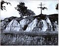
 Landslide terrace, north bank of Caddo Lake, c. 1910
 -
 Potters Point, north shore of Caddo Lake, c. 1910
 -
 South bank of Caddo Lake, c. 1910
 -
 Caddo Lake Aerial view in 1935, Mooringsport, LA in the foreground


.jpg)
Wildlife
Wildlife inhabiting Caddo Lake includes owls, snakes, frogs, waterfowl, bobcats, river otters, beavers, eagles, and
Preservation efforts
In 1993 Caddo Lake preservation efforts were expanded. The Nature Conservancy had purchased 7,000 acres (2,833 ha) of the Caddo Lake area and announced an agreement to merge this property with the 483 acres (195 ha) Texas Caddo State Park, creating the
As of 2003, Caddo Lake
From 2001 until 2003 Caddo Lake residents fought a legal battle with the City of Marshall, Texas over water rights.[citation needed]
Current threat
The lake is "under siege" by a fast-spreading, Velcro-like aquatic fern, Salvinia molesta, also known as Giant Salvinia. Accidentally introduced to the lake by boaters, the noxious weed doubles in size every two to four days, rapidly killing off life below the surface. Most of the growth of the plant is on the Louisiana side. Officials have been focused on recovering from damage caused by Hurricanes Katrina and Rita in 2005.[7]
Efforts at removing the weed have included biological means via beetles that normally eat the weed, but these were unable to survive the Texas cold. Herbicide is also being used against the invasive fern. The Texas Water Resource Institute's Caddo Lake Salvinia Eradication Project is evaluating multiple methods of eradication.[8]
Texas Bigfoot
Since 1965 Texas's Caddo Lake has been the center of hundreds of alleged Bigfoot sightings, according to the North American Wood Ape Conservancy (NAWAC). This was reported in the Travel Channel 2006 documentary Bigfoot.[citation needed]
Cities and towns on Caddo Lake
See also
- Caddo Lake State Park
- List of lakes in Louisiana
- List of lakes in Texas
References
- ^ "Caddo Lake". Ramsar Sites Information Service. Retrieved 25 April 2018.
- ^ TPWD: Caddo Lake State Park
- ^ Shannon Tompkins (2009). "Caddo Lake's history is the stuff of legend" (PDF). Houston Chronicle. Retrieved 2013-07-17.
- ^ The first "over water" oil well
- ^ Janes, Lionel. 1914. Examination of Ferry (Caddo) Lake. Volume II. U.S. Department of the Interior. 187 pages.
- ^ In pictures: The week in wildlife | Environment | guardian.co.uk
- ^ In East Texas, Residents Take On a Lake-EatingMonster - New York Times
- ^ Caddo Lake Salvinia Eradication | Center for Invasive Species Eradication
- Bagur, Jacques D. 2001. A History of Navigation on Cypress Bayou and the Lakes. The University of North Texas Press, Denton, TX
- Keeland, B.D. and P.J. Young. 1997. "Long-term growth trends of baldcypress (Taxodium distichum (L.) Rich.) at Caddo Lake, Texas", Wetlands 17(4): 559/566.
- King, S.L., B.D. Keeland, and J.L. Moore. "Beaver lodge distributions and damage assessments in a forested wetland ecosystem in the southern United States", Forest Ecology and Management 108(1-2).
External links
- North American Wood Ape Conservancy
- Travel Channel Website
- U.S. Geological Survey Geographic Names Information System: Caddo Lake
- Caddo Lake from the Handbook of Texas Online
| National | |
|---|---|
| Other | |