
Salta–Antofagasta railway
| Salta–Antofagasta railway | |||
|---|---|---|---|
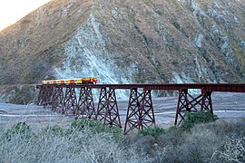
 A train near the passing loop of Pascua, 2019 | |||
| Overview | |||
| Other name(s) | Huaytiquina | ||
| Native name | Ramal Salta–Antofagasta | ||
| Status | Active | ||
| Owner |
| ||
| Line number | |||
| Locale | metre gauge | ||
| |||

The Salta–Antofagasta railway, also named Huaytiquina,
Overview
The Argentine track (a brief portion -
With the highest point (
History

The construction of the railway started in 1921, to connect the North of Argentina with Chile across the Andes, and to serve the
The word "Huaytiquina" is the nickname of the railway. It refers to an ancient Andean mountain pass between Argentina and Chile, located just in north of Socompa and projected as line terminus. In 1923, after a Chilean request whose rail line arrived close to Socompa, the original project was abandoned and the Argentine route diverted to the current one.[8]
In March 2022, the Government of Salta Province met with executives of Chilean company Ferronor with the purpose of bringing back a passenger service between Argentina and Chile. The project include the reactivation of a 700-km line that joins both countries through Socompa Pass, located 3,876 mt above sea level. There is a precedent of an agreement between both parties when Belgrano Cargas and Ferronor signed in 2000 to facilitate freight transport commerce.[9]
Route

The line crosses the north-western side of
It serves the town of San Antonio de los Cobres, in the middle of the Puna de Atacama, nearby copper mines. After the viaduct La Polvorilla, highest point of the line (4,220 m), the railway runs on the borders of Jujuy Province at Olacapato and, between Tolar Grande and Caipe, it crosses in the middle a dry lake named Salar de Arizaro. The station of Socompa, named after the Andean vulcan, is a bi-national station located between the Argentinian-Chilean frontier line.[11]
Entering the Chilean territory, the rest of the line crosses the municipal territory of Antofagasta, located in the homonymous province and region. Varillas and Augusta Victoria have a short industrial rail branches, the one of Varillas serving Escondida mine. At Palestina station, the line crosses the junction railway Baquedano-Aguas Blancas, named FF.CC. Longitudinal (owned by Ferronor), linking the lines Antofagasta-La Paz and Antofagasta-Copiapó. Descending the western slopes of the Andes and the Atacama Desert, the "Huayitquina" reaches the industrial complex and village of La Negra and, after 22 km, the Pacific Ocean in the port city of Antofagasta.
Train services
Salta–Antofagasta Railway | ||||||||||||||||||||||||||||||||||||||||||||||||||||||||||||||||||||||||||||||||||||||||||||||||||||||||||||||||||||||||||||||||||||||||||||||||||||||||||||||||||||||||||||||||||||||||||||||||||||||||||||||||||||||||||||||||||||||||||||||||||||||||||||||||||||||||||||||||||||||||||||||||||||||||||||||||||||||||||||||||||||||||||||||||||||||||||||||||||||||||||||||||||||||||||||||||||||||||||||||||||||||||||||||||||||||||||||||||||||||||||||||||||||||||||||||||||||||||||||||||||||||||||||||||||||||||||||||||||||||||||||||||||||||||||||||||||||||
|---|---|---|---|---|---|---|---|---|---|---|---|---|---|---|---|---|---|---|---|---|---|---|---|---|---|---|---|---|---|---|---|---|---|---|---|---|---|---|---|---|---|---|---|---|---|---|---|---|---|---|---|---|---|---|---|---|---|---|---|---|---|---|---|---|---|---|---|---|---|---|---|---|---|---|---|---|---|---|---|---|---|---|---|---|---|---|---|---|---|---|---|---|---|---|---|---|---|---|---|---|---|---|---|---|---|---|---|---|---|---|---|---|---|---|---|---|---|---|---|---|---|---|---|---|---|---|---|---|---|---|---|---|---|---|---|---|---|---|---|---|---|---|---|---|---|---|---|---|---|---|---|---|---|---|---|---|---|---|---|---|---|---|---|---|---|---|---|---|---|---|---|---|---|---|---|---|---|---|---|---|---|---|---|---|---|---|---|---|---|---|---|---|---|---|---|---|---|---|---|---|---|---|---|---|---|---|---|---|---|---|---|---|---|---|---|---|---|---|---|---|---|---|---|---|---|---|---|---|---|---|---|---|---|---|---|---|---|---|---|---|---|---|---|---|---|---|---|---|---|---|---|---|---|---|---|---|---|---|---|---|---|---|---|---|---|---|---|---|---|---|---|---|---|---|---|---|---|---|---|---|---|---|---|---|---|---|---|---|---|---|---|---|---|---|---|---|---|---|---|---|---|---|---|---|---|---|---|---|---|---|---|---|---|---|---|---|---|---|---|---|---|---|---|---|---|---|---|---|---|---|---|---|---|---|---|---|---|---|---|---|---|---|---|---|---|---|---|---|---|---|---|---|---|---|---|---|---|---|---|---|---|---|---|---|---|---|---|---|---|---|---|---|---|---|---|---|---|---|---|---|---|---|---|---|---|---|---|---|---|---|---|---|---|---|---|---|---|---|---|---|---|---|---|---|---|---|---|---|---|---|---|---|---|---|---|---|---|---|---|---|---|---|---|---|---|---|---|---|---|---|---|---|---|---|---|---|---|---|---|---|---|---|---|---|---|---|---|---|---|---|---|---|---|---|---|---|---|---|---|---|---|---|---|---|---|---|---|---|---|---|---|---|---|---|---|---|---|---|---|---|---|---|---|---|---|---|---|---|---|---|---|---|---|---|---|---|---|---|---|---|---|---|---|---|---|---|---|---|---|---|---|---|---|---|---|---|---|---|---|---|---|---|---|---|---|---|---|---|---|---|---|---|---|---|---|---|---|---|---|---|---|---|---|---|---|---|---|---|---|---|
Huaytiquina Railway
| ||||||||||||||||||||||||||||||||||||||||||||||||||||||||||||||||||||||||||||||||||||||||||||||||||||||||||||||||||||||||||||||||||||||||||||||||||||||||||||||||||||||||||||||||||||||||||||||||||||||||||||||||||||||||||||||||||||||||||||||||||||||||||||||||||||||||||||||||||||||||||||||||||||||||||||||||||||||||||||||||||||||||||||||||||||||||||||||||||||||||||||||||||||||||||||||||||||||||||||||||||||||||||||||||||||||||||||||||||||||||||||||||||||||||||||||||||||||||||||||||||||||||||||||||||||||||||||||||||||||||||||||||||||||||||||||||||||||
| ||||||||||||||||||||||||||||||||||||||||||||||||||||||||||||||||||||||||||||||||||||||||||||||||||||||||||||||||||||||||||||||||||||||||||||||||||||||||||||||||||||||||||||||||||||||||||||||||||||||||||||||||||||||||||||||||||||||||||||||||||||||||||||||||||||||||||||||||||||||||||||||||||||||||||||||||||||||||||||||||||||||||||||||||||||||||||||||||||||||||||||||||||||||||||||||||||||||||||||||||||||||||||||||||||||||||||||||||||||||||||||||||||||||||||||||||||||||||||||||||||||||||||||||||||||||||||||||||||||||||||||||||||||||||||||||||||||||
Due to a presence of
Gallery
-
 Train at Augusta Victoria station
 -
 El Toro viaduct, between Campo Quijano and El Alisal
 -
 The Tren a las Nubes crossing a bridge
 -
 A cargo train at Ingeniero Maury station
 -
 La Polvorilla viaduct
 -
 Domingo F. Sarmiento station
 -
 Laguna Seca station
 -
 Antofagasta station building


See also
- List of highest railways in the world
- Trans-Andean railways: rail services in the Andean and atlantic countries.
- Transandine Railway (Argentina-Chile): defunct line, pending reconstruction, linking Mendoza to Santiago.
References
- ^ (in Spanish) Salta-Socompa: 1999 timetable (source for km distances, not all stations shown)
- ^ Benedetti, Alejandro (December 2005). "El ferrocarril Huaytiquina, entre el progreso y el fracaso: Aproximaciones desde la geografía histórica del territorio de los Andes" [The Huaytiquina railroad, between the progress and the failure. Approaches from historical geography of territorio de los Andes]. Revista Escuela de Historia (in Spanish) (4): 123–165.
- ^ Timetable Güemes-Salta-Socompa
- ^ (in Spanish) Historical infos about the "Ramal C-14"
- ^ Infos, map and km at Tren a las Nubes website
- ^ (in Spanish) Historical infos, photos and maps at amigosdeltren.cl
- ^ Tren de las Nubes - Visit Argentina
- ^ (in Spanish) Questions and answers about the Ramal C-14
- ^ El tren de pasajeros que une a Salta con Chile está cada vez más cerca de volver a funcionar on Weekend magazine, 23 Mar 2022
- ^ "meseta" in Spanish means plateau
- ^ Satellite view of Socompa station at Google Maps
- ^ (in Spanish) "Ramal C-14" website (section
"Trenes", subsection"Trenes de Carga") - Consulted on 8-4-2012 - ^ (in Spanish) "Ramal C-14" website (section
"Trenes", subsection"Tren Mixto") - Consulted on 8-4-2012 - ^ Salta-Socompa: 1948 timetable
- ^ (in Spanish) Article about a project for an urban rail in Antofagasta (El Nortero website)
- ^ "Work starts on trans-Andean link". Railway Gazette International
External links
- Historia del Ferrocarril de Antofagasta a Salta on Amigos del Tren (archived, 7 Jan 2011)
- El Ramal C-14 y el Tren a las Nubes (archived, 4 Dec 2017)
- Ferrocarril Antofagasta–Bolivia on Markus' Classic Trains
- Tren a las Nubes official website
| Main divisions | |
|---|---|
| Commuter rail lines | |
| International | |
| Touristic | |
| Rapid transit and Light rail | |
| Freight lines and facilities | |
| Projects | |
| Accidents | |
| Related topics | |