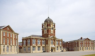
Sandhurst, Berkshire
| Sandhurst | ||
|---|---|---|
Shire county | ||
| Region | ||
| Country | England | |
| Sovereign state | United Kingdom | |
| Post town | SANDHURST | |
| Postcode district | GU47 | |
| Dialling code | 01344 01276 01252 | |
| Police | Thames Valley | |
| Fire | Royal Berkshire | |
| Ambulance | South Central | |
| UK Parliament | ||
Sandhurst is a town and
Geography
| Sandhurst | ||||||||||||||||||||||||||||||||||||||||||||||||||||||||||||
|---|---|---|---|---|---|---|---|---|---|---|---|---|---|---|---|---|---|---|---|---|---|---|---|---|---|---|---|---|---|---|---|---|---|---|---|---|---|---|---|---|---|---|---|---|---|---|---|---|---|---|---|---|---|---|---|---|---|---|---|---|
| Climate chart (explanation) | ||||||||||||||||||||||||||||||||||||||||||||||||||||||||||||
| ||||||||||||||||||||||||||||||||||||||||||||||||||||||||||||
| ||||||||||||||||||||||||||||||||||||||||||||||||||||||||||||
Sandhurst is in
Sandhurst is bordered, on the south, by the
.


Transport
Sandhurst lies just off the A30, which is 3.4 miles (5.5 km) away from junction 4 of the M3 motorway. It is also located 10 miles (16 km) from the M4, via the Crowthorne bypass (A3095) to Bracknell and the A329(M) towards Reading.
Stagecoach South operates bus route 3 between Yateley and Camberley every 15 minutes except on Sundays; alternate services extends to and from Aldershot.[8]
Local government
Sandhurst has representation through several tiers of government –
History
Saxon and Medieval periods
The name of the village is
Tudor to Georgian periods
In the early modern era, Sandhurst
Victorian and Modern periods
Life changed very little in Sandhurst until the 19th century when large sections of land were sold for the building of the
Such large houses and institutions, including the
- Parish Church, Little Sandhurst, dates from the 13th century, but was largely rebuilt in 1853.[10]
- The Baptist Church, Central Sandhurst, was built in 1884.
- The Wesleyan Methodist chapel, Central Sandhurst, followed in 1906.
- The St George's Church | St George's Church | Owlsmoor, Owlsmoor, was built as an iron church in 1880 and was rebuilt in 1993.[10]
- The Roman Catholic Church of the Immaculate Conception, Yorktown Road, was built in 1959.
- Old Scotland Hill, Little Sandhurst, in 1871,
- The Methodist, Central Sandhurst, in 1906,
- College Town in 1907,
- Uplands, Central Sandhurst, in 1962 and
- Owlsmoor Primary was added in 1974.
Recreation and sport
- The Tug of War Association National Outdoor Tug of War Championships were held in Sandhurst in the year 2000 and 2013.
- The Sandhurst tug of war team have been three times World champions, as seen on sign posts entering the town, next to Sandhurst Memorial Park.
- Sandhurst's football team, Sandhurst Town F.C., has its home ground at Bottom Meadow. It currently plays in the Combined County League Division 1.
- The boys and girls football club, offers football to all children aged 6 to 21 in the area and has over 750 registered players. The kit consists of the badge, the number in grey at the back and vertical red and white stripes which fade into white at the bottom. The shorts are black.
- Sandhurst Cricket Club field two teams in the Berkshire League with the 1st XI in the premier division. They also have a Sunday side and a Midweek XI, plus a growing junior section (U11s & U9s).
- Sandhurst Joggers has more than 400 members ranging from novices to athletes competing in a variety of local races, regional and National Championships and organises runs on 6 days of the week. It was founded in 1987.
- Sandhurst playground (with a large sand-play area) and a small skatepark. Pistachios in the Park is in the vicinity. The park has a large water area (called a balancing pond) where a firework show is held once a year, usually on the closest Saturday to Guy Fawkes Night and the Sandhurst Donkey Derby is also an annual event. The Memorial Park is home to Sandhurst Memorial parkrun, a weekly 5k run held in the United Kingdom. It is held every Saturday at 9.00am and takes in a route that includes the River Blackwaterand Shepherd Meadows.
- Sandhurst Leisure Centre is in the Owlsmoor area. It is facilitated by Sandhurst Schooland has various facilities for sporting and recreational activities.
- Sandhurst has an active Historical Society.
- Sandhurst Silver Band Organisation rehearse in their own facility in the town and maintain two separate bands - The Sandhurst Community Band and the Sandhurst Silver Band. In March 2018, Sandhurst Silver Band became London and Southern Counties First Section Champions, earning an invitation to the National Finals in September 2018.
Notable people
- William, Prince of Wales (then Prince William of Wales) resided at the Royal Military Academy between January and December 2006.
- Greg Davies, the actor and comedian, was an English & Drama teacher at Sandhurst School in the 1990s.[13]
- Max and Harvey, twin musicians and social media stars.
References
- ^ "Sandhurst Town Council". www.sandhurst.gov.uk.
- ^ Marks & Spencer – Sandhurst, Bracknell Forest. Yelp.co.uk (15 May 2012). Retrieved on 17 July 2013.
- ^ Meadows Shopping Centre. Meadowscentre.co.uk. Retrieved on 17 July 2013.
- ^ Bracknell Forest Council. "Planning permission granted". Archived from the original on 28 June 2013.
- ^ "Magic Map Application". Magic.defra.gov.uk. Retrieved 14 April 2017.
- ^ Opening Times. "Wildmoor Heath | Berks, Bucks & Oxon Wildlife Trust". Bbowt.org.uk. Retrieved 14 April 2017.
- ^ "Train Times". Great Western Railway. 21 May 2023. Retrieved 4 October 2023.
- ^ "Stops in Sandhurst". Bus Times. 2023. Retrieved 4 October 2023.
- ^ "Your Councillors". www.sandhurst.gov.uk. Retrieved 9 January 2024.
- ^ ISBN 9781905191017.
- ^ a b c Ford, David Nash (2001). "History of Sandhurst, Berkshire". Royal Berkshire History. Nash Ford Publishing. Retrieved 28 December 2010.
- ^ Emma Hodge, Catherine Wilkins (2017). History and Guide of St Michael and All Angels Church, Sandhurst.
- ^ Bond, Kimberley (2018). "Who is Greg Davies?". Radio Times. Immediate Media Company Ltd. Retrieved 8 May 2021.
Sources
- PH Ditchfield (1923), The Victoria County History of Berkshire.
