
Sandridge Bridge
Sandridge Bridge | |
|---|---|
.jpg) | |
| Coordinates | 37°49′13″S 144°57′47″E / 37.8202°S 144.963°E |
| Carries | Pedestrians, cyclists |
| Crosses | Yarra River |
| Locale | Melbourne, Australia |
| Characteristics | |
| Design | Steel girder |
| Total length | 178.4 m (585 ft) |
| Width | 17 m (55.8 ft) |
| Longest span | 36.9 m (121.1 ft) |
| History | |
| Opened | 1888 |
| Location | |
 | |
The Sandridge Bridge is a historic bridge, which originally carried railway lines over the
History


The first bridge was built in 1853 for the
The current bridge was designed by the
The use of the bridge by the Port Melbourne and St Kilda railway lines ceased in 1987, when both lines were converted to
The viaduct over Queensbridge Street and the embankment across the South Bank were listed by the National Trust and were noted as being historically significant, but were removed. Only the bridge over the river itself was retained,[5] with a number of different redevelopment plans proposed during the 1990s.
Redevelopment
.jpg)
In 2001, the State Government held an expressions of interest process for refurbishment of the bridge, seeking commercial involvement, but the process was not successful and, in 2003, the
The refurbished bridge was unveiled three days before the 2006 Commonwealth Games in Melbourne, at a final cost of $18.5 million.[9] It included a new pedestrian and cycle path, and public space, connecting a new Queensbridge Square at Southbank to Flinders Walk on the north bank. However, only the eastern half of the bridge was reopened, the western half being stabilised and fenced off from public access.
On 11 June 2007, the bridge was vandalised when persons unknown used a sledgehammer to smash 46 of the 128 glass panels of the Travellers exhibit. Each glass panel offers information about Australian indigenous peoples or the countries of immigrants to Australia, from Afghanistan to Zimbabwe. It was expected to cost between A$200,000 and A$300,000 to repair and city councillors were considering using more durable materials to replace the glass.[10][needs update]
In 2007, the project was awarded the Melbourne Prize by the Victorian Chapter of the Australian Institute of Architects, for its design and its contribution to the public life of Melbourne.
Specifications
The bridge is 178.4 metres (585 ft) long and is made up of five spans, measuring in length, from the south bank to the north bank: 36.9 metres (121.1 ft), 36.6 metres (120.1 ft), 36.3 metres (119.1 ft), 36.9 metres (121.1 ft) and 31.7 metres (104 ft). The bridge is 17 metres (55.8 ft) wide and the girders are 2.74 metres (8.98 ft) high from the top to the bottom flange.
Gallery
-
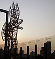
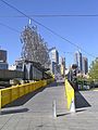
 Sculptures on the Sandridge Bridge
 -
 The glass panels contain information about each country from which immigrants came to Melbourne.
 -
 The bridge as viewed from Southbank.
 -
 Vandalised glass panels have been sectioned off behind temporary fencing.
 -
 Sandridge Bridge Towards Flinders Street station
 -
 Sandridge Bridge (Built 1888) Redeveloped in South Bank End
 -
 Melbourne South Bank & Sandridge Bridge
 -
 Sandridge Bridge with South & North Banks


References
- ^ a b c d "Sandridge Railway Line Bridge". Victorian Heritage Database. Heritage Council of Victoria. Retrieved 1 December 2023.
- ISSN 1449-6291.
- ^ "Line data: St Kilda line". VICSIG - Infrastructure. vicsig.net. Retrieved 5 July 2008.
- ^ "Sandridge rail bridge". National Trust of Australia. Retrieved 5 July 2008.
- ^ a b "Port Melbourne Flinders Street Railway Reservation, South Melbourne, VIC Profile". Aussie Heritage. Archived from the original on 10 August 2008. Retrieved 5 July 2008.
- ^ "Port Melbourne line 1971". Victorian Railways signal diagram. victorianrailways.net. Retrieved 5 July 2008.
- ^ Southern Public Transport Link Feasibility Study (PDF). 1991. pp. 2–3.
- ^ a b "Travellers tales to be writ large on Sandridge Bridge". Media Release: Minister for Planning, Minister for Arts. legislation.vic.gov.au. 8 May 2005. Archived from the original on 7 March 2012. Retrieved 5 July 2008.
- ^ a b Rumble, Chantal (13 March 2006). "Revamped bridge makes the journey worthwhile". The Age. Retrieved 5 July 2008.
- ^ Miletic, Daniella; Money, Lawrence (14 June 2007). "Disbelief at vandal's attack on migrant tribute". The Age. Retrieved 5 July 2008.
| Preceding station | Disused railways | Following station | ||
|---|---|---|---|---|
| Flinders Street | Port Melbourne line | Montague
| ||
| Flinders Street | St Kilda line | South Melbourne
| ||
| List of closed railway stations in Melbourne | ||||
