
South Benfleet
This article needs additional citations for verification. (April 2017) |
| South Benfleet | ||
|---|---|---|
Shire county | ||
| Region | ||
| Country | England | |
| Sovereign state | United Kingdom | |
| Post town | BENFLEET | |
| Postcode district | SS7 | |
| Dialling code | 01268 | |
| Police | Essex | |
| Fire | Essex | |
| Ambulance | East of England | |
| UK Parliament | ||
South Benfleet is a town and former civil parish, in the Castle Point district of Essex, England, 30 miles east of London. It is adjacent to the village of North Benfleet. The Benfleet (SS7) post town includes South Benfleet, Thundersley, New Thundersley and Hadleigh. The Battle of Benfleet took place here between the Vikings and Saxons in 894.[2] In 1951 the parish had a population of 8191.[3]
The community is directly north of Canvey Island and is served by Benfleet railway station. It hosts South Benfleet Primary School, which was used temporarily to house local residents during the widespread flooding of 1953.
At the junction of Saint Mary's Church and The Anchor pub is the site of the UK's first "overrunable" mini roundabout.[4]
History
In Roman times the reclaimed area which is now Canvey Island was joined to the mainland by a road providing access from Benfleet at low tides to Camulodunum (Colchester) and Londinium (London). The A130 road from Sadlers Farm roundabout to Canvey Island follows the route of the original Roman road. Its construction in 1971 brought to light a number of artifacts dating back to the early settlements in the area.
The name of the town originates from the time of the
In Saxon times the village became known as South Benfleet when a new settlement, which became known as Little Benfleet, developed to the north of the original settlement. The new settlement did not last, and its site, which has since become known as North Benfleet, is now largely rural.
The railway was brought to the town in 1855. The new Benfleet railway station connected the town with Southend-on-Sea to the east and London Fenchurch Street station.
In July 2002, Castle Point District Council named a 6-mile cycle way, from near Benfleet railway station to near Leigh-on-Sea railway station, the "de Neumann Way" after Captain Peter de Neumann, GM.
Battle of Benfleet
The
In December 2008 a sculpture commemorating the battle was erected in Ferry Road, South Benfleet.[6]
Geography
Local towns
- Southend-on-Sea
- Basildon
- Pitsea
- Canvey Island
- Hadleigh
- Leigh-on-Sea
- Thundersley
- New Thundersley[7]
- Rayleigh
Governance
There are two tiers of local government covering South Benfleet, at
South Benfleet was an
Benfleet Urban District was abolished on 1 April 1974 under the Local Government Act 1972, becoming part of the new district of Castle Point. No successor parish was created for the former urban district and so it became an unparished area.[10]
Transport
Benfleet railway station is served by the London, Tilbury and Southend railway line, currently run by c2c rail. By road the A13 and A12/A127/A130 connect the town to London.
Notable people
- Ron Martin – Southend United Chairman
- Ashley George Old the war artist is buried there
- Nicola Willis - Olympic gymnast[11]
Landmarks

The Church of England in Benfleet is served by the Church of St Mary the Virgin. The public houses located in the Monument and St Mary's area of the town include The Anchor, The Hoy and Helmet and the Half Crown. Further north is the Benfleet Tavern. There is also a range of restaurants in the South Benfleet conservation area.
Benfleet Water Tower (TQ 790 867) is a brick built structure built in 1903, which is 30m high with a 22m mast sited on the roof. All radio equipment is housed within the tower. Being on a prominent hilltop, some 137m amsl, this is an exceptional radio transmission and reception site. Coverage includes the whole estuary, including the Isle of Grain, Medway Towns, Southend, Bradwell, Danbury etc. This site provides both Highband and Lowband CBS systems.
Sport
Benfleet FC are members of the Essex Olympian Football League.[citation needed] The First Team play in Senior Division 1 and Seconds in the Reserve Division 2.[citation needed] There is also a third team who compete in the Mid-Essex Division 3. The club play their home fixtures at Woodside Park Extension at the top of Manor Road. Fixtures are organised on a Saturday afternoon, with some mid-week fixtures towards the end of the season.
Benfleet is the home to Sceptre League Division 1 Sunday team Benfleet FC, who finished 8th in 2010/2011 season.[citation needed]
Benfleet FC (Sunday) managed to win the Mike Wigget Cup in 2009/2010 season, beating Shoebury Boys 4–2 in the final at Burroughs Park, Great Wakering.[citation needed]
Benfleet Vikings RFC are the town's local rugby club, formed in 2013, with Senior, Youth, and Minis sides.[citation needed] The senior side currently compete in the Shepherd Neame Essex Merit League 6 East and play their home fixtures on Saturdays at Richmond Park, off of Brook Road.
Benfleet is also home to South Benfleet United F.C., a football club formed in 1978 for youth football but is now a men's and veterans' (over 35s) club.[citation needed] Their men's team currently play in the Sceptre League and their veterans teams are in the Premier Division and Division 3 of the Southend Borough Combination Veterans League.
Benfleet Cricket Club (established 1948) currently play their home matches at Woodside Park at the top of Manor Road. Members of the Hambro Financial Cricket League (formerly Shepherd Neame Essex League), they currently field five adult teams on a Saturday, two adult teams on a Sunday, and teams at u9, u11, u13 and u15 age groups in competitions organised by the South Essex Cricket Participation Group.
In popular culture
Benfleet was referred to as Beamfleot in The Saxon Stories by Bernard Cornwell.
Images
-
 Clock on Vic House roundabout
 -
 One of the last true Bluebell woods in Essex (Shipwrights Drive)
 -
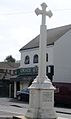 War Monument, South Benfleet


See also
References
- ^ Map of South Benfleet manor (and later parish)
- ISBN 9780711227439. Retrieved 2 April 2010.
- A Vision of Britain through Time. Retrieved 25 December 2021.
- ISBN 978-0-19-967154-0.
- ^ "CHURCH OF ST MARY THE VIRGIN, Non Civil Parish - 1123690 | Historic England". historicengland.org.uk. Retrieved 18 January 2022.
- ^ "Battle memorial's stylish fence". Echo. 9 February 2009. Retrieved 18 January 2022.
- ^ "History of New Thundersley, in Castle Point and Essex | Map and description".
- ^ "South Benfleet Ancient Parish / Civil Parish". A Vision of Britain through Time. GB Historical GIS / University of Portsmouth. Retrieved 22 August 2023.
- ^ "Rochford Registration District". UKBMD. Retrieved 25 December 2021.
- ^ "The English Non-metropolitan Districts (Definition) Order 1972", legislation.gov.uk, The National Archives, SI 1972/2039, retrieved 31 May 2023
- ^ "Gymnastics: Nicola's the UK number one". Daily Gazette. 1 November 2001. Retrieved 4 February 2019.
- Norman M. Chisman, D.P.A., Bygone Benfleet, Phillimore, 1991
External links
![]() Media related to South Benfleet at Wikimedia Commons
Media related to South Benfleet at Wikimedia Commons
| Unitary authorities |
|
|---|---|
| Boroughs or districts | |
| Major settlements (cities in italics) |
|
| Rivers |
|