
Sullivan County, Indiana
39°05′N 87°25′W / 39.09°N 87.41°W
Sullivan County | |
|---|---|
UTC−4 (EDT) | |
| Congressional district | 8th |
| Website | www |
| Indiana county number 77 | |
Sullivan County is a
Sullivan County is included in the Terre Haute, Indiana, metropolitan statistical area.
History
On February 25, 1779, Col.
The county's first settlement occurred between 1808 and 1812, by a religious society of celibates known as Shakers. The 400 members of this communal group occupied 1,300 acres (5 km2), seven miles (11 km) west of Carlisle.
General William Henry Harrison’s army made its last camp in Sullivan County at Big Springs on September 29, 1811. Harrison used Benjamin Turman's fort as his headquarters. With spring water available, it was an ideal location for 1000 men, including 160 dragoons and 60 mounted riflemen. A Kentucky soldier killed a fellow Kentuckian, Clark, either accidentally or in a grudge fight. The deceased was buried at the top of a hill that became the Mann Turman Cemetery. General Harrison and his troops continued north on the Wea Indiana Trail to build Fort Harrison and then proceeded to the Battle of Tippecanoe.
A War of 1812 military action occurred in September 1812, three miles (4.8 km) west−southwest of Sullivan County. While escorting supplies from Fort Knox near Vincennes to Fort Harrison at Terre Haute, Sergeant Nathan Fairbanks and approximately a dozen soldiers were ambushed - and most killed - by Indians.
In 1815, Carlisle was founded.
An act of the Indiana legislature dated December 30, 1816, created Sullivan County, with areas partitioned from Knox County. The effective date of the new government was January 15, 1817, with interim commissioners charged to begin organizing the new government in February.[4][5][6] It was named for Daniel Sullivan, a prominent frontiersman killed in 1790 by Native Americans while carrying a dispatch between Fort Vincennes and Louisville.
A log courthouse in Merom served as Sullivan County's first county seat from 1819 to 1842. Merom was an important river port and a stop on the stage route known as The Old Harrison Trail. William Henry Harrison's troops camped near here on their 1811 march to the Battle of Tippecanoe.
Pioneer heroine of abdominal surgery Jane Todd is buried in Sullivan County. Born in
Sullivan was founded in 1853 and became the county seat.
Dedicated in 1862,
Numerous violent conflicts erupted in Sullivan County during the
In November 1902, a mob abducted James Dillard from the Sullivan County sheriff, John S. Dudley, as he was being taken to Sullivan. After kidnapping Dillard, they lynched him.[7][8] In response to the lynching, Governor Winfield Durbin dismissed the sheriff - a decision which was in line with Indiana's 1899 anti-lynching law.[9] However, Sheriff Dudley ultimately remained in office after he and other officials entered into a legal battle about the decision.[10][7]
Organized nationally to bring culture to rural communities, Merom's 10-day religious and educational Chautauqua event featured concerts, debates, plays, and lectures. Carrie Nation, William Jennings Bryan, William Howard Taft, Warren G. Harding, and Billy Sunday were among its speakers.
In 1968, the Sullivan County Park and Lake was created. It contains a 468-acre (1.9 km2)
Geography
Sullivan County lies on the west edge of Indiana; its western border abuts the state of Illinois (across the Wabash River). The meanders of the Wabash delineate the county's west border. The upper part of the county is drained by Turtle Creek, which flows southwestward into the river. The lower part of the county is similarly drained by Busseron Creek.
The county's abundant woods were largely cleared and devoted to agriculture during the nineteenth century. At present only the drainages remain wooded.[11] Its highest point (640 feet/200 meters ASL) is a small rise six miles (9.7 km) east of Carlisle.[12]
According to the 2010 census, the county has a total area of 454.12 square miles (1,176.2 km2), of which 447.14 square miles (1,158.1 km2) (or 98.46%) is land and 6.97 square miles (18.1 km2) (or 1.53%) is water.[13]
Adjacent counties
- Vigo County − north
- Clay County − northeast
- Greene County − east
- Knox County − south
- Crawford County, Illinois − west
- Clark County, Illinois − northwest
Protected areas
- Elliott Woods State Nature Preserve
- Greene-Sullivan State Forest(part)
- Redbird State Recreation Area (part)
- Shakamak State Park (part)
- Sullivan County Park and Lake
- Turtle Creek Reservoir
City
- Sullivan - county seat
Towns
Unincorporated communities
- Baker
- Baldridge
- Benefiel Corner
- Bucktown
- Cass
- Curryville
- Dodds Bridge
- East Shelburn
- Fairbanks
- Gambill
- Gilmour − part
- Glendora
- Graysville
- Greenville
- Hawton
- Jackson Hill
- Jericho
- Lewis − part
- Massacre
- Merom Station
- New Lebanon
- Paxton
- Pleasantville
- Riverton
- Riverview
- Scotchtown
- Scott City
- Shiloh
- Standard
- Stringtown
- Wilfred
Ghost towns
Townships
Transportation
Major highways
 U.S. Route 41
- U.S. Route 150
- State Road 48
- State Road 54
- State Road 58
- State Road 63
- State Road 154
- State Road 159
Airport
The county contains one public-use airport, the Sullivan County Airport (SIV) at Sullivan.[14]
Economy
Education
Sullivan County is served by two school corporations, the Southwest School Corporation and the Northeast School Corporation. The former's high school is Sullivan High School in Sullivan, and the latter's high schools are North Central High School in Farmersburg and Union High School in Dugger. Union Christian College formerly operated in Merom.
Climate and weather
| Sullivan, Indiana | ||||||||||||||||||||||||||||||||||||||||||||||||||||||||||||
|---|---|---|---|---|---|---|---|---|---|---|---|---|---|---|---|---|---|---|---|---|---|---|---|---|---|---|---|---|---|---|---|---|---|---|---|---|---|---|---|---|---|---|---|---|---|---|---|---|---|---|---|---|---|---|---|---|---|---|---|---|
| Climate chart (explanation) | ||||||||||||||||||||||||||||||||||||||||||||||||||||||||||||
| ||||||||||||||||||||||||||||||||||||||||||||||||||||||||||||
| ||||||||||||||||||||||||||||||||||||||||||||||||||||||||||||
In recent years, average temperatures in Sullivan have ranged from a low of 18 °F (−8 °C) in January to a high of 85 °F (29 °C) in July, although a record low of −33 °F (−36 °C) was recorded in January 1994 and a record high of 98 °F (37 °C) was recorded in July 1999. Average monthly precipitation ranged from 2.58 inches (66 mm) in February to 4.69 inches (119 mm) in July.[17]
Government
The county government is a constitutional body, and is granted specific powers by the Constitution of Indiana, and by the Indiana Code.
County Council: The legislative branch of the county government; controls spending and revenue collection in the county. Representatives are elected to four-year terms from county districts. They set salaries, the annual budget, and special spending. The council has limited authority to impose local taxes, in the form of an income and property tax that is subject to state level approval, excise taxes, and service taxes.[18][19]
Board of Commissioners: The executive body of the county; commissioners are elected county-wide to staggered four-year terms. One commissioner serves as president. The commissioners execute acts legislated by the council, collect revenue, and manage the county government.[18][19]
Court: The county maintains a small claims court that handles civil cases. The judge on the court is elected to a term of four years and must be a member of the Indiana Bar Association. The judge is assisted by a constable who is also elected to a four-year term. In some cases, court decisions can be appealed to the state level circuit court.[19]
County Officials: The county has other elected offices, including sheriff, coroner, auditor, treasurer, recorder, surveyor, and circuit court clerk. These officers are elected to four-year terms. Members elected to county government positions are required to declare party affiliations and to be residents of the county.[19]
| Year | Republican | Democratic | Third party | |||
|---|---|---|---|---|---|---|
| No. | % | No. | % | No. | % | |
| 2020 | 6,691 | 74.28% | 2,153 | 23.90% | 164 | 1.82% |
| 2016 | 6,138 | 71.26% | 2,113 | 24.53% | 362 | 4.20% |
| 2012 | 4,902 | 59.13% | 3,191 | 38.49% | 197 | 2.38% |
| 2008 | 4,343 | 49.45% | 4,284 | 48.78% | 155 | 1.76% |
| 2004 | 4,999 | 59.55% | 3,341 | 39.80% | 54 | 0.64% |
| 2000 | 4,319 | 52.28% | 3,833 | 46.39% | 110 | 1.33% |
| 1996 | 3,207 | 37.11% | 4,076 | 47.17% | 1,359 | 15.73% |
| 1992 | 3,052 | 33.29% | 4,211 | 45.93% | 1,905 | 20.78% |
| 1988 | 4,246 | 49.39% | 4,320 | 50.25% | 31 | 0.36% |
| 1984 | 4,771 | 54.14% | 4,006 | 45.46% | 36 | 0.41% |
| 1980 | 4,465 | 49.05% | 4,335 | 47.62% | 303 | 3.33% |
| 1976 | 3,747 | 41.61% | 5,198 | 57.72% | 61 | 0.68% |
| 1972 | 5,338 | 59.30% | 3,624 | 40.26% | 39 | 0.43% |
| 1968 | 4,266 | 43.20% | 4,453 | 45.10% | 1,155 | 11.70% |
| 1964 | 3,867 | 34.34% | 7,351 | 65.28% | 42 | 0.37% |
| 1960 | 6,012 | 49.85% | 5,975 | 49.54% | 73 | 0.61% |
| 1956 | 5,829 | 48.79% | 6,048 | 50.63% | 69 | 0.58% |
| 1952 | 5,929 | 45.65% | 6,964 | 53.62% | 95 | 0.73% |
| 1948 | 4,824 | 40.88% | 6,705 | 56.82% | 272 | 2.30% |
| 1944 | 5,855 | 47.23% | 6,420 | 51.79% | 122 | 0.98% |
| 1940 | 6,471 | 42.32% | 8,667 | 56.69% | 151 | 0.99% |
| 1936 | 4,685 | 30.92% | 10,203 | 67.33% | 266 | 1.76% |
| 1932 | 3,667 | 29.39% | 7,835 | 62.80% | 975 | 7.81% |
| 1928 | 6,199 | 51.09% | 5,642 | 46.50% | 293 | 2.41% |
| 1924 | 5,139 | 42.64% | 5,213 | 43.25% | 1,701 | 14.11% |
| 1920 | 5,376 | 41.38% | 6,160 | 47.42% | 1,455 | 11.20% |
| 1916 | 2,630 | 35.24% | 3,880 | 51.99% | 953 | 12.77% |
| 1912 | 1,406 | 18.52% | 3,707 | 48.82% | 2,480 | 32.66% |
| 1908 | 2,942 | 35.67% | 4,657 | 56.46% | 649 | 7.87% |
| 1904 | 3,076 | 42.17% | 3,641 | 49.91% | 578 | 7.92% |
| 1900 | 2,326 | 35.29% | 4,008 | 60.81% | 257 | 3.90% |
| 1896 | 2,317 | 36.15% | 4,010 | 62.57% | 82 | 1.28% |
| 1892 | 1,784 | 32.66% | 3,159 | 57.84% | 519 | 9.50% |
| 1888 | 1,902 | 35.56% | 3,382 | 63.24% | 64 | 1.20% |
Demographics
| Census | Pop. | Note | %± |
|---|---|---|---|
| 1820 | 3,498 | — | |
| 1830 | 4,630 | 32.4% | |
| 1840 | 8,315 | 79.6% | |
| 1850 | 10,141 | 22.0% | |
| 1860 | 15,064 | 48.5% | |
| 1870 | 18,453 | 22.5% | |
| 1880 | 20,336 | 10.2% | |
| 1890 | 21,877 | 7.6% | |
| 1900 | 26,005 | 18.9% | |
| 1910 | 32,439 | 24.7% | |
| 1920 | 31,630 | −2.5% | |
| 1930 | 28,133 | −11.1% | |
| 1940 | 27,014 | −4.0% | |
| 1950 | 23,667 | −12.4% | |
| 1960 | 21,721 | −8.2% | |
| 1970 | 19,889 | −8.4% | |
| 1980 | 21,107 | 6.1% | |
| 1990 | 18,993 | −10.0% | |
| 2000 | 21,751 | 14.5% | |
| 2010 | 21,475 | −1.3% | |
| 2020 | 20,817 | −3.1% | |
| 2023 (est.) | 20,757 | [21] | −0.3% |
| US Decennial Census[22] 1790-1960[23] 1900-1990[24] 1990-2000[25] 2010-2021[2] | |||
2010 census
As of the
Of the 7,823 households, 31.7% had children under the age of 18 living with them, 53.4% were married couples living together, 10.8% had a female householder with no husband present, 30.7% were non-families, and 26.7% of all households were made up of individuals. The average household size was 2.45 and the average family size was 2.94. The median age was 39.8 years.[26]
The median income for a household in the county was $47,697 and the median income for a family was $52,558. Males had a median income of $44,645 versus $26,335 for females. The per capita income for the county was $20,093. About 8.5% of families and 11.9% of the population were below the
-
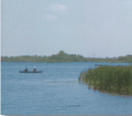 Turtle Creek Reservoir
 -
 Sullivan County Park & Lake
 -
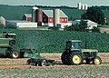 Sullivan County Farm
 -
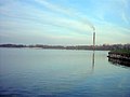 Merom Power Station
 -
 Sullivan Public Library
.png)
.jpg)

.jpg)

See also
References
- ^ "Mean Center of Population for the United States: 1790 to 2000" (PDF). US Census Bureau. Archived from the original (PDF) on November 3, 2001. Retrieved September 17, 2011.
- ^ a b "Sullivan County QuickFacts". United States Census Bureau. Retrieved January 1, 2023.
- ^ "Find a County". National Association of Counties. Retrieved June 7, 2011.
- ^ Thomas J. Wolfe, ed. (1909). "A History of Sullivan County, Indiana". Retrieved November 4, 2020.
- ^ "Organization Of Sullivan County". Sullivan County, Indiana. Sullivan County Historical Society. Retrieved July 12, 2014.
- ^ "Sullivan County, Indiana". STATS Indiana. Indiana Business Research Center. Retrieved July 12, 2014.
- ^ a b Tribune-Star, Lisa Trigg. "One lynching each recorded in Sullivan, Vigo histories". Terre Haute Tribune-Star. Retrieved April 15, 2022.
- ^ McCormick, Mike (November 17, 2002). "A lynching, fightin' women, and a visit from Eugene V. Debs mark 100 years ago". Terre Haute Tribune Star. Retrieved April 15, 2022.
- ^ Madison, James H. (2001). A Lynching in the Heartland: Race and Memory in America. New York: Palgrave. pp. 18–19.
- ^ Cutler, James Elbert (1905). Lynch-law: An Investigation Into the History of Lynching in the United States. Longmans, Green, and Company.
- ^ Sullivan County IN (Google Maps, accessed 4 November 2020)
- ^ Sullivan County High Point, Indiana (PeakBagger.com, accessed 4 November 2020)
- ^ a b "Population, Housing Units, Area, and Density: 2010 - County". US Census Bureau. Archived from the original on February 12, 2020. Retrieved July 10, 2015.
- ^ Public and Private Airports, Sullivan County, Indiana
- ^ [1] Peabody Energy Earnings Report 2011
- ^ "Miners To Be Laid Off As Peabody Scales Back Production". Inside Indiana Business. November 6, 2019. Retrieved November 4, 2020.
- ^ a b "Monthly Averages for Sullivan, Indiana". The Weather Channel. Retrieved January 27, 2011.
- ^ a b Indiana Code. "Title 36, Article 2, Section 3". IN.gov. Retrieved September 16, 2008.
- ^ a b c d Indiana Code. "Title 2, Article 10, Section 2" (PDF). IN.gov. Archived (PDF) from the original on December 27, 2004. Retrieved September 16, 2008.
- ^ Leip, David. "Atlas of US Presidential Elections". uselectionatlas.org. Retrieved May 20, 2018.
- ^ "Annual Estimates of the Resident Population for Counties: April 1, 2020 to July 1, 2023". United States Census Bureau. Retrieved April 2, 2024.
- ^ "US Decennial Census". US Census Bureau. Retrieved July 10, 2014.
- ^ "Historical Census Browser". University of Virginia Library. Retrieved July 10, 2014.
- ^ "Population of Counties by Decennial Census: 1900 to 1990". US Census Bureau. Retrieved July 10, 2014.
- ^ "Census 2000 PHC-T-4. Ranking Tables for Counties: 1990 and 2000" (PDF). US Census Bureau. Archived (PDF) from the original on March 27, 2010. Retrieved July 10, 2014.
- ^ a b c "Profile of General Population and Housing Characteristics: 2010 Demographic Profile Data". US Census Bureau. Archived from the original on February 13, 2020. Retrieved July 10, 2015.
- ^ "Selected Social Characteristics in the US – 2006-2010 American Community Survey 5-Year Estimates". US Census Bureau. Archived from the original on February 14, 2020. Retrieved July 10, 2015.
- ^ "Selected Economic Characteristics – 2006-2010 American Community Survey 5-Year Estimates". US Census Bureau. Archived from the original on February 14, 2020. Retrieved July 10, 2015.
External links
Places adjacent to Sullivan County, Indiana | ||||||||||||||||
|---|---|---|---|---|---|---|---|---|---|---|---|---|---|---|---|---|
| ||||||||||||||||
 | ||||
| Towns | ||||
| Townships | ||||
| CDPs | ||||
| Other communities | ||||
| Ghost towns | ||||
| Footnotes | ‡This populated place also has portions in an adjacent county or counties | |||
| ||||
| International | |
|---|---|
| National | |
| Other | |