
Taum Sauk Mountain
| Taum Sauk Mountain | |
|---|---|
U.S. state high point 41st | |
| Coordinates | 37°34′13″N 90°43′40″W / 37.5703266°N 90.7279003°W[2] |
| Geography | |
 Taum Sauk Mountain | |
Saint Francois Mountains | |
| Topo map | USGS Ironton |
| Climbing | |
| Easiest route | Hike |
Taum Sauk Mountain
Description
While relatively low in terms of elevation at 1,772 feet (540 m) compared to
Taum Sauk is said to be named for a Piankeshaw chief named Sauk-Ton-Qua.[3]
Though Taum Sauk Mountain is the highest mountain in Missouri, it is not the most prominent. Taum Sauk rises 522 feet (159 m) from an already elevated base.[6] Mudlick Mountain rises 693 feet (211 m) from a lower base to an elevation of 1,313 feet (400 m).[7] Black Mountain, in Madison County, has the highest rise in elevation in Missouri. From its base, along the St. Francis River (540 feet above sea level) to its summit (1,502 feet [458 m] above sea level), Black Mountain rises just under 1,000 feet (300 m) in elevation from the valley below.
State park

In 1991 Missouri created
Mina Sauk Falls, the highest waterfall in Missouri, is on Taum Sauk and can be visited by hiking a rugged trail that makes a 3-mile (4.8 km) loop from the highpoint parking area. These falls normally have water cascading over them only during times of wet weather. At other times they are reduced to a trickle or less.
The

-
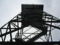 Taum Sauk lookout tower.
 -
 View from lookout tower.
 -
 The highest natural point in the U.S. state of Missouri at 1,772 feet.
 -
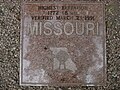 Granite plaque placed by the Missouri Association of Registered Land Surveyors
 -
 Mina Sauk Falls, the highest waterfall in Missouri.
.JPG)
.JPG)


See also
References
Specific references
- ^ a b "Taum Sauk Mountain, Missouri". Peakbagger.com. Retrieved 2012-11-09.
- ^ "Taum Sauk Mountain". Geographic Names Information System. United States Geological Survey, United States Department of the Interior. Retrieved 2012-11-09.
- ^ a b Mary Eakins Bullis (November 2007). "The Legend of Taum Sauk Mountain". Missouri Vacation!. River Valley Region Association. Retrieved 2010-09-19.
Long before the white man came here ... this land of flowers, now called the Arcadia Valley, was the hunting grounds of the Piankashaw Indians. The Piankashaws had a famous chieftain, Sauk-Ton-Qua. Because the name was hard for the white man to pronounce, he was later called Taum Sauk.
— See also Combinations of vowel letters. - ^ "Elevations and Distances in the United States (online edition)". United States Geological Survey. 2001. Retrieved 2008-01-24.
- ^ Irontown, Missouri, 7.5 Minute Topographic Quadrangle, USGS, 1968 (1978 rev.)
- ^ "Taum Sauk Mountain, Missouri". PeakBagger.com. Retrieved 2012-10-11.
- ^ "Most Prominent Peaks of the U.S. States". PeakBagger.com. Retrieved 2012-10-11.
- ^ "Taum Sauk Section". The Ozark Trail. The Ozark Trail Association. Retrieved 2008-12-15.
General references
- Unklesbay, A.G; & Vineyard, Jerry D. (1992). Missouri Geology — Three Billion Years of Volcanoes, Seas, Sediments, and Erosion. University of Missouri Press. ISBN 0-8262-0836-3.
External links
- "Taum Sauk Mountain". SummitPost.org.