
Mauna Kea
| Mauna Kea | ||
|---|---|---|
| Maunakea Hawaii highest major peaks 1st | ||
| Coordinates | 19°49′14.4″N 155°28′05.0″W / 19.820667°N 155.468056°W[2] | |
| Geography | ||
 Mauna Kea Position of Mauna Kea in Hawaiʻi  Mauna Kea Mauna Kea (Hawaii) | ||
| Location | Last eruption 2460 BCE ± 100 years | |
| Climbing | ||
| First ascent | Recorded: Goodrich (1823)[5] | |
| Easiest route | Mauna Kea Trail | |
| Designated | November 1972 | |
Mauna Kea (
It is about one million years old and thus passed the most active
In
With its high elevation, dry environment, and stable airflow, Mauna Kea's summit is one of the best sites in the world for astronomical observation. Since the creation of an access road in 1964, thirteen telescopes funded by eleven countries have been constructed at the summit. The Mauna Kea Observatories are used for scientific research across the electromagnetic spectrum and comprise the largest such facility in the world. Their construction on a landscape considered sacred by Native Hawaiians continues to be a topic of debate to this day.
Topographic prominence

Mauna Kea is unusually topographically prominent for its height, with a wet prominence fifteenth in the world among mountains, and a dry prominence second in the world, after only Mount Everest.[12] It is the highest peak on its island, so its wet prominence matches its height above sea level, at 4,207.3 m (13,803 ft).[12] Because the Hawaiian Islands slope deep into the ocean, Mauna Kea has a dry prominence of 9,330 m (30,610 ft).[12] This dry prominence is taller than Mount Everest's height above sea level of 8,848.86 m (29,032 ft), so Everest would have to include whole continents in its foothills to exceed Mauna Kea's dry prominence.
Given how much Mauna Kea protrudes from the
Geology
Mauna Kea is one of five volcanoes that form the island of Hawaiʻi, the largest and youngest island of the Hawaiian–Emperor seamount chain.[21] Of these five hotspot volcanoes, Mauna Kea is the fourth oldest and fourth most active.[4] It began as a preshield volcano driven by the Hawaiʻi hotspot around one million years ago, and became exceptionally active during its shield stage until 500,000 years ago.[22] Mauna Kea entered its quieter post-shield stage 250,000 to 200,000 years ago,[23] and is currently active, having last erupted between 4,500 and 6,000 years ago.[8] Mauna Kea does not have a visible summit caldera, but contains a number of small cinder and pumice cones near its summit. A former summit caldera may have been filled and buried by later summit eruption deposits.
Mauna Kea is over 32,000 km3 (7,680 cu mi) in volume, so massive that it and its neighbor,

The volcano continues to
Like all Hawaiian volcanoes, Mauna Kea has been created as the
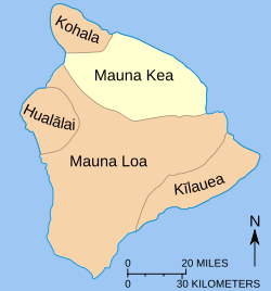
Lava flows from Mauna Kea overlapped in complex layers with those of its neighbors during its growth. Most prominently, Mauna Kea is built upon older flows from Kohala to the northwest, and intersects the base of Mauna Loa to the south.[24] The original eruptive fissures (rift zones) in the flanks of Mauna Kea were buried by its post-shield volcanism.[23] Hilo Ridge, a prominent underwater rift zone structure east of Mauna Kea, was once believed to be a part of the volcano; however, it is now understood to be a rift zone of Kohala that has been affected by younger Mauna Kea flows.[28][31]
The shield-stage lavas that built the enormous main mass of the volcano are

Mauna Kea is the only Hawaiian volcano with distinct evidence of
At their maximum extent, the glaciers extended from the summit down to between 3,200 and 3,800 m (10,500 and 12,500 ft) of elevation.[38] A small body of permafrost, less than 25 m (80 ft) across, was found at the summit of Mauna Kea before 1974, and may still be present.[28] Small gullies etch the summit, formed by rain- and snow-fed streams that flow only during winter melt and rain showers.[39] On the windward side of the volcano,
Mauna Kea is home to
No artesian water was known on the island of Hawaiʻi until 1993 when drilling by the
Future activity
The last eruption of Mauna Kea was about 4,600 years ago (about 2600 BC);
Despite its dormancy, Mauna Kea is expected to erupt again. Based on earlier eruptions, such an event could occur anywhere on the volcano's upper flanks and would likely produce long lava flows, mostly of
Human history
Native history

The first
Early settlement of the Hawaiian islands led to major changes to local ecosystems and many extinctions, particularly amongst bird species. Ancient Hawaiians brought foreign plants and animals, and their arrival was associated with increased rates of erosion.[49] The prevailing lowland forest ecosystem was transformed from forest to grassland; some of this change was caused by the use of fire, but the prevailing cause of forest
The five volcanoes of Hawaiʻi are revered as
Around AD 1100, natives established adze quarries high up on Mauna Kea to extract the uniquely dense basalt (generated by the quick cooling of lava flows meeting glacial ice during subglacial eruptions) to make tools. Volcanic glass and gabbro were collected for blades and fishing gear, and māmane wood was preferred for the handles. At peak quarry activity after AD 1400, there were separate facilities for rough and fine cutting; shelters with food, water, and wood to sustain the workers; and workshops creating the finished product.[48]
Lake Waiau provided drinking water for the workers. Native chiefs would also dip the umbilical cords of newborn babies in its water, to give them the strength of the mountain. Use of the quarry declined between this period and contact with Americans and Europeans. As part of the ritual associated with quarrying, the workers erected shrines to their gods; these and other quarry artifacts remain at the sites, most of which lie within what is now the Mauna Kea Ice Age Reserve.[48]
This early era was followed by cultural expansion between the 12th and late 18th century. Land was divided into regions designed for the immediate needs of the populace. These
Modern era
.jpg)
There are three accounts of foreigners visiting Hawaiʻi before the arrival of James Cook, in 1778.[52][53][54] However, the earliest Western depictions of the isle, including Mauna Kea, were created by explorers in the late 18th and early 19th centuries. Contact with Europe and America had major consequences for island residents. Native Hawaiians were devastated by introduced diseases; port cities including Hilo, Kealakekua, and Kailua grew with the establishment of trade; and the adze quarries on Mauna Kea were abandoned after the introduction of metal tools.[48]
In 1793, cattle were brought by George Vancouver as a tribute to King Kamehameha I. By the early 19th century, they had escaped confinement and roamed the island freely, greatly damaging its ecosystem. In 1809 John Palmer Parker arrived and befriended Kamehameha I, who put him in charge of cattle management on the island. With an additional land grant in 1845, Parker established Parker Ranch on the northern slope of Mauna Kea, a large cattle ranch that is still in operation today.[48] Settlers to the island burned and cut down much of the lower native forest for sugarcane plantations and houses.[55]
.jpg)
The
The Pohakuloa Training Area on the plateau is the largest military training ground in Hawaiʻi. The 108,863-acre (44,055 ha) base extends from the volcano's lower flanks to 2,070 m (6,790 ft) elevation, on state land leased to the US Army since 1956. There are 15 threatened and endangered plants, three endangered birds, and one endangered bat species in the area.[39]
Mauna Kea has been the site of extensive archaeological research since the 1980s. Approximately 27 percent of the Science Reserve had been surveyed by 2000, identifying 76 shrines, 4 adze manufacturing workshops, 3 other markers, 1 positively identified burial site, and 4 possible burial sites.[48] By 2009, the total number of identified sites had risen to 223, and archaeological research on the volcano's upper flanks is ongoing.[39] It has been suggested that the shrines, which are arranged around the volcano's summit along what may be an ancient snow line, are markers for the transition to the sacred part of Mauna Kea. Despite many references to burial around Mauna Kea in Hawaiian oral history, few sites have been confirmed. The lack of shrines or other artifacts on the many cinder cones dotting the volcano may be because they were reserved for burial.[48]
Ascents

In pre-contact times, natives traveling up Mauna Kea were probably guided more by landscape than by existing trails, as no evidence of trails has been found. It is possible that natural ridges and water sources were followed instead. Individuals likely took trips up Mauna Kea's slopes to visit family-maintained shrines near its summit, and traditions related to ascending the mountain exist to this day. However, very few natives reached the summit, because of the strict kapu placed on it.[48]
In the early 19th century, the earliest notable recorded ascents of Mauna Kea included the following:
- On August 26, 1823,
- On June 17, 1825, an expedition from HMS Blonde, led by botanist James Macrae, reached the summit of Mauna Kea. Macrae was the first person to record the Mauna Kea silversword (Argyroxiphium sandwicense), saying: "The last mile was destitute of vegetation except one plant of the Sygenisia tribe, in growth much like a Yucca, with sharp pointed silver coloured leaves and green upright spike of three or four feet producing pendulous branches with brown flowers, truly superb, and almost worth the journey of coming here to see it on purpose."[5]
- In January 1834, David Douglas climbed the mountain and described extensively the division of plant species by altitude. On an unrelated traverse, from Kamuela to Hilo in July, he was found dead in a pit intended to catch wild cattle. Although murder was suspected, it was probably an accidental fall. The site, Ka lua kauka 19°53′17″N 155°20′17″W / 19.88806°N 155.33806°W, is marked by the Douglas fir trees named for him.[56]
- In 1881, Kingdom of Hawaiʻi.[48]
- On August 6, 1889, E.D. Baldwin left Hilo and followed cattle trails to the summit.[5]
- In February 2021, Victor Vescovo and Clifford Kapono made the first ascent of Mauna Kea from its subaerial base 16,785 ft below sea level using the submersible Limiting Factor, then ocean kayaks from above the mountain base 27 miles to the shoreline, then bicycles to a camp at about 9000 ft altitude from which they then walked to the 13,802 ft summit (a total gain of 30,587 ft).[57]
In the late 19th and early 20th centuries trails were formed, often by the movement of game herds, that could be traveled on horseback.[48] However, vehicular access to the summit was practically impossible until the construction of a road in 1964, and it continues to be restricted.[58] Today, multiple trails to the summit exist, in various states of use.[39]
Ecology
Background
Hawaiʻi's
Contact with Americans and Europeans in the early 19th century brought more settlers to the island, and had a lasting negative ecological effect. On lower slopes, vast tracts of koa–ʻōhiʻa forest were converted to farmland. Higher up, feral animals that escaped from ranches found refuge in, and damaged extensively, Mauna Kea's native māmane–naio forest.[60] Non-native plants are the other serious threat; there are over 4,600 introduced species on the island, whereas the number of native species is estimated at just 1,000.[61]
Alpine environment

The summit of Mauna Kea lies above the tree line, and consists of mostly lava rock and alpine tundra. An area of heavy snowfall, it is inhospitable to vegetation, and is known as the Hawaiian tropical high shrublands. Growth is restricted here by extremely cold temperatures, a short growing season, low rainfall, and snow during winter months. A lack of soil also retards root growth, makes it difficult to absorb nutrients from the ground, and gives the area a very low water retention capacity.[5]
Plant species found at this elevation include
The

Wēkiu bugs feed on dead insect carcasses that drift up Mauna Kea on the wind and settle on snow banks. This is a highly unusual food source for a species in the genus Nysius, which consists of predominantly seed-eating insects. They can survive at extreme elevations of up to 4,200 m (13,780 ft)[64] because of natural antifreeze in their blood. They also stay under heated surfaces most of the time. Their conservation status is unclear, but the species is no longer a candidate for the Endangered Species List; studies on the welfare of the species began in 1980. The closely related Nysius aa lives on Mauna Loa. Wolf spiders (Lycosidae) and forest tent caterpillar moths have also been observed in the same Mauna Kea ecosystem; the former survive by hiding under heat-absorbing rocks, and the latter through cold-resistant chemicals in their bodies.[65] Several native moths are also present near the summit including Agrotis helela and Agrotis kuamauna.
Māmane–naio forest

The forested zone on the volcano, at an elevation of 2,000–3,000 m (6,600–9,800 ft), is dominated by māmane (Sophora chrysophylla) and naio (Myoporum sandwicense), both endemic tree species, and is thus known as māmane–naio forest. Māmane seeds and naio fruit are the chief foods of the birds in this zone, especially the palila (Loxioides bailleui). The palila was formerly found on the slopes of Mauna Kea, Mauna Loa, and Hualālai, but is now confined to the slopes of Mauna Kea—only 10% of its former range—and has been declared critically endangered.[55]
The largest threat to the ecosystem is
The court ruled in favor of conservationists and upheld the precedence of federal laws before state control of wildlife. Having violated the Endangered Species Act, Hawaiʻi state was required to remove all feral animals from the mountainside.[55] This decision was followed by a second court order in 1981. A public hunting program removed many of the feral animals,[60] at least temporarily. An active control program is in place,[39] though it is not conducted with sufficient rigor to allow significant recovery of the māmane-naio ecosystem.[69] There are many other species and ecosystems on the island, and on Mauna Kea, that remain threatened by human development and invasive species.[55]
The Mauna Kea Forest Reserve protects 52,500 acres (212 km2) of māmane-naio forest under the jurisdiction of the Hawaii Department of Land and Natural Resources. Ungulate hunting is allowed year-round.[39] A small part of the māmane–naio forest is encompassed by the Mauna Kea State Recreation Area.[70]
Lower environment
A band of ranch land on Mauna Kea's lower slopes was formerly
The Hakalau Forest National Wildlife Refuge is a major koa forest reserve on Mauna Kea's windward slope. It was established in 1985, covering 32,733 acres (13,247 ha) of ecosystem remnant. Eight endangered bird species, twelve endangered plants, and the endangered Hawaiian hoary bat (Lasiurus cinereus semotus) have been observed in the area, in addition to many other rare biota. The reserve has been the site of an extensive replanting campaign since 1989.[72] Parts of the reserve show the effect of agriculture on the native ecosystem,[60] as much of the land in the upper part of the reserve is abandoned farmland.[72]
Bird species native to the acacia koa–ʻōhiʻa forest include the
Summit observatories

Mauna Kea's summit is one of the best sites in the world for
In the early 1960s, the Hawaiʻi Island

By 1970, two 24 in (0.6 m) telescopes had been constructed by the
Today the Mauna Kea Science Reserve has 13 observation facilities, each funded by as many as 11 countries.[76] There are nine telescopes working in the visible and infrared spectrum, three in the submillimeter spectrum, and one in the radio spectrum, with mirrors or dishes ranging from 0.9 to 25 m (3 to 82 ft).[77] In comparison, the Hubble Space Telescope has a 2.4 m (7.9 ft) mirror, similar in size to the UH88, now the second smallest telescope on the mountain.[77]
A "Save Mauna Kea" movement believes development of the mountain to be sacrilegious.[78] Native Hawaiian non-profit groups such as Kahea, concerned with cultural heritage and the environment, also oppose development for cultural and religious reasons.[79] The multi-telescope "outrigger" proposed in 2006 was eventually canceled.[80] A planned new telescope, the Thirty Meter Telescope (TMT), has attracted controversy and protests.[81][82] The TMT was approved in April 2013.[83] In October 2014, the groundbreaking ceremony for the telescope was interrupted by protesters causing the project to temporarily halt.[84] In late March 2015, demonstrators blocked access of the road to the summit again.[85] On April 2, 2015, 300 protestors were gathered near the visitor center when 12 people were arrested with 11 more arrested at the summit.[86][87] Among the concerns of the protest groups are the land appraisals and Native Hawaiians consultation.[86] Construction was halted on April 7, 2015, after protests expanded over the state.[88] After several halts, the project has been voluntarily postponed. Governor Ige announced substantial changes to the management of Mauna Kea in the future but stated the project can move forward.[89] The Supreme Court of Hawaiʻi approved the resumption of construction on October 31, 2018.[90] Protestors have posted online petitions as a reaction against the Thirty Meter Telescope. The online petition titled "The Immediate Halt to the Construction of the TMT Telescope" was posted to Change.org on July 14, 2019. The online petition has currently gathered over 278,057 signatures worldwide.[91] Some protesters have also called for the impeachment of Hawaiian Governor David Ige because of his support for the Thirty Meter Telescope. On July 18, 2019, an online petition titled "Impeach Governor David Ige" had been posted to Change.org and has currently gathered over 62,562 signatures.[92]
As of late 2021, construction plans are currently on hold due to the ongoing effects of the COVID-19 pandemic and a shift in funding for the project that may see federal funds made available through the National Science Foundation.[93] The controversy surrounding construction of the Thirty Meter Telescope continues. Independent polls commissioned by local media organizations[94][95] show consistent support for the project in the islands with over two thirds of local residents supporting the project. These same polls indicate Native Hawaiian community support remains split with about half of Hawaiian respondents supporting construction of the new telescope.
A July 2022 state law responds to the protests by shifting control over the master land lease from the University of Hawaii to the new Mauna Kea Stewardship and Oversight Authority (MKSOA).[96] The MKSOA is a 12-member board (11 voting members and 1 non-voting member) which includes representatives from the university, astronomers and native Hawaiians[97] and it was created with the aim of finding a balance between the conflicting interests of astronomers and native Hawaiians. It is placed within the Hawaii department of land and natural resources and will be the principal authority for the management of state-managed lands within the Mauna Kea lands after a 5-year transition period from the university starting on July 1, 2023.[98] During the transition period, the MKSOA and the university will jointly manage the land while the authority develops a management plan to govern land uses, human activities, and overall operations.[98] Once the transition period is up in 2028, the authority's responsibilities will include issuing new land use permits which will be important as the current master lease ends in 2033, and any observatories which don't come up with new leases by the time of its expiration will be decommissioned.[99]
Climate
Mauna Kea has an alpine climate (ET). Due to the influence of its tropical latitude, temperature swings are very low. Frosts are common year round, but the average monthly temperature remains above freezing throughout the year.
Snow may fall at an altitude of 11,000 ft (3,353 m) and above in any month, but occurs most often from October to April.[100]
A weather station was operated from 1972 to 1982; however, only 33 months within this period have temperature records; many years only have data for two months. The temperatures presented below are smoothed averages, not the raw numbers recorded by NOAA.
| Climate data for Mauna Kea Observatory, elevation: 13,800 ft (4,206 m) | |||||||||||||
|---|---|---|---|---|---|---|---|---|---|---|---|---|---|
| Month | Jan | Feb | Mar | Apr | May | Jun | Jul | Aug | Sep | Oct | Nov | Dec | Year |
| Record high °F (°C) | 55 (13) |
56 (13) |
54 (12) |
55 (13) |
59 (15) |
58 (14) |
75 (24) |
57 (14) |
60 (16) |
59 (15) |
54 (12) |
55 (13) |
75 (24) |
| Mean daily maximum °F (°C) | 42.0 (5.6) |
42.5 (5.8) |
40.3 (4.6) |
41.4 (5.2) |
47.5 (8.6) |
49.3 (9.6) |
50.9 (10.5) |
49.9 (9.9) |
50.5 (10.3) |
43.8 (6.6) |
45.1 (7.3) |
42.7 (5.9) |
45.5 (7.5) |
| Mean daily minimum °F (°C) | 26.3 (−3.2) |
26.1 (−3.3) |
24.9 (−3.9) |
26.2 (−3.2) |
29.0 (−1.7) |
29.4 (−1.4) |
30.3 (−0.9) |
30.9 (−0.6) |
31.3 (−0.4) |
29.5 (−1.4) |
27.8 (−2.3) |
27.6 (−2.4) |
28.3 (−2.1) |
| Record low °F (°C) | 19 (−7) |
12 (−11) |
18 (−8) |
18 (−8) |
12 (−11) |
23 (−5) |
22 (−6) |
17 (−8) |
23 (−5) |
20 (−7) |
20 (−7) |
17 (−8) |
12 (−11) |
| Average precipitation inches (mm) | 0.81 (21) |
0.24 (6.1) |
1.05 (27) |
0.50 (13) |
0.92 (23) |
0.14 (3.6) |
0.29 (7.4) |
0.77 (20) |
0.51 (13) |
0.58 (15) |
1.04 (26) |
0.52 (13) |
7.37 (188.1) |
| Source: Western Regional Climate Center[101] | |||||||||||||
Recreation
Mauna Kea's coastline is dominated by the
There are over 3,000 registered hunters on Hawaii island, and hunting, for both recreation and sustenance, is a common activity on Mauna Kea. A public hunting program is used to control the numbers of introduced animals including pigs, sheep, goats, turkey,

Mauna Kea's great height and the steepness of its flanks provide a better view and a shorter hike than the adjacent Mauna Loa. The height with its risk of altitude sickness, weather concerns, steep road grade, and overall inaccessibility make the volcano dangerous and summit trips difficult. Until the construction of roads in the mid-20th century, only the hardy visited Mauna Kea's upper slopes; hunters tracked game animals, and hikers traveled up the mountain. These travelers used stone cabins constructed by the Civilian Conservation Corps in the 1930s as base camps, and it is from these facilities that the modern mid-level Onizuka Center for International Astronomy telescope support complex is derived. The first Mauna Kea summit road was built in 1964, making the peak accessible to more people.[58]
Today, multiple hiking trails exist, including the Mauna Kea Trail, and by 2007 over 100,000 tourists and 32,000 vehicles were going each year to the Visitor Information Station (VIS) adjacent to the Onizuka Center for International Astronomy. The Mauna Kea Access Road is paved up to the Center at 2,804 m (9,199 ft).[39] One study reported that around a third of visitors and two-thirds of professional astronomers working on the mountain have experienced symptoms of acute altitude sickness.[105] Visitors to the mountain should prepare ahead of time by acclimating at a lower elevation or using a prescription medicine like Diamox.[106] It is strongly recommended to use a four-wheel drive vehicle to drive all the way to the top. Brakes often overheat on the way down and there is no fuel available on Mauna Kea.[107] A free Star Gazing Program was previously held at the VIS every night from 6-10 pm, with the program canceled due to both a change in operating hours and closure due to the ongoing COVID-19 pandemic.[108][109] Between 5,000 and 6,000 people visit the summit of Mauna Kea each year, and to help ensure safety, and protect the integrity of the mountain, a ranger program was implemented in 2001.[39]
See also
- Evolution of Hawaiian volcanoes
- List of mountain peaks of the United States
- List of volcanoes of the United States
- List of tallest mountains in the Solar System
- List of the highest major summits of the United States
- List of the most isolated major summits of the United States
- List of the most prominent summits of the United States
- List of Ultras of Oceania
Footnotes
- ^ Such as National Geographic,[9] Guinness World Records,[10] and the U.S. Geological Survey.[11] Definitions of base vary and it is less clearly defined than the concept of prominence. This is discussed further in the topographic prominence section of this article.
References
- ^ "Why does OMKM spell "Maunakea" as one word?". Office of Maunakea Management. Archived from the original on September 3, 2018. Retrieved February 26, 2019.
- ^ United States National Geodetic Survey. Archivedfrom the original on February 2, 2016. Retrieved October 27, 2015.
- ^ "Mauna Kea". Summits of the World. peakbagger.com. Archived from the original on October 23, 2015. Retrieved October 27, 2015.
- ^ a b c d e f "Mauna Kea Hawai'i's Tallest Volcano". Hawaiian Volcano Observatory – United States Geological Survey. May 22, 2002. Archived from the original on September 4, 2010. Retrieved August 8, 2010.
- ^ JSTOR 1930491. (subscription required)
- ISBN 978-1-4058-8118-0.
- ^ a b Hit, Christine (August 5, 2019). "The Sacred History of Maunakea". Honolulu Magazine. Archived from the original on September 24, 2020. Retrieved July 28, 2021.; Fujikane, Candace (September 1, 2019). "Mapping Abundance on Mauna a Wākea as a Practice of Ea". Hūlili: Multidisciplinary Research on Hawaiian Well-Being. Vol. 11, no. 1. pp. 23–54.
- ^ a b "Active Volcanoes of Hawaii | U.S. Geological Survey". www.usgs.gov. Retrieved May 1, 2023.
- ^ a b c "Mauna Kea" (PDF). National Geographic. Archived (PDF) from the original on August 12, 2021. Retrieved October 10, 2021.
- ^ a b "Tallest Mountain". Guinness World Records. Archived from the original on January 21, 2015. Retrieved January 21, 2015.
- ^ a b c "How High is Mauna Loa?". U.S. Geological Survey. Archived from the original on October 10, 2021. Retrieved October 10, 2021.
- ^ ISBN 9781412059954.
- ISBN 978-3-540-43650-8.
- ^ "How Big Are Hawaiian Volcanoes?". U.S. Geological Survey. Archived from the original on February 5, 2022.
- ^ "How Do Scientists Determine the World's Tallest Mountain?". wisegeek. August 9, 2023.
- ^ "Geography of Guam". Government of Guam. Archived from the original on April 12, 2020. Retrieved October 10, 2021.
- ^ "Beneath the mountains". Archived from the original on February 21, 2015. Retrieved January 21, 2015.
- ^ "Peru-Chile Trench | trench, Pacific Ocean". Encyclopedia Britannica. Archived from the original on May 14, 2015. Retrieved October 11, 2021.
- ^ "Llullaillaco". Global Volcanism Program. Smithsonian Institution. Archived from the original on November 18, 2021. Retrieved November 22, 2021.
- ISBN 978-3-540-45904-0. Retrieved September 5, 2024.
- ^ a b c Watson, Jim (May 5, 1999). "The long trail of the Hawaiian hotspot". United States Geological Survey. Archived from the original on February 4, 2012. Retrieved August 26, 2010.
- (PDF) from the original on December 10, 2015. Retrieved May 22, 2002.
- ^ a b c d Cannon, E.C.; Bürgmann, R. Roland (October 26, 2009). "Complete Report for Mauna Kea Volcano (Class B) No. 2601". United States Geological Survey. Archived from the original on March 5, 2012. Retrieved August 9, 2010.
- ^ a b Wolfe, E.W.; Wise, W.S.; Dalrymple, G.B. (1997). The geology and petrology of Mauna Kea volcano, Hawaii : a study of postshield volcanism. Professional Paper 1557. United States Geological Survey. Archived from the original on June 15, 2011. Retrieved September 18, 2010.
- ^ "Mauna Kea: Hawaiian Volcano Observatory". Hawaiian Volcano Observatory – United States Geological Survey. January 2, 2018. Archived from the original on January 6, 2020. Retrieved February 24, 2020.
- ^ "Mauna Loa, Hawaiian Volcano Observatory, Summary" (archive). volcanoes.usgs.gov. United States Geological Survey. November 2, 2017. Retrieved February 12, 2019.
- ^ "Science In Your Backyard: Hawaii". United States Geological Survey. October 2, 2009. Archived from the original on November 4, 2010. Retrieved October 25, 2010.
- ^ a b c d e f Sherrod, David R.; Sinton, John M.; Watkins, Sarah E.; Brunt, Kelly M. (2007). "Geological Map of the State of Hawaii" (PDF). Open File report 2007-1089. United States Geological Survey. pp. 44–48. Archived (PDF) from the original on January 18, 2016. Retrieved April 12, 2009.
- ^ Foulger, G.R; Anderson, Don L. (March 11, 2006). "The Emperor and Hawaiian Volcanic Chains: How well do they fit the plume hypothesis?". MantlePlumes.org. Archived from the original on January 16, 2012. Retrieved April 1, 2009.
- ^ Clague, David A.; Dalrymple, G. Brent (1987). "The Hawaiian-Emperor Volcanic Chain – Geological Evolution" (PDF). In Decker, Robert W.; Wright, Thomas L.; Straffer, Peter H. (eds.). Volcanism in Hawaii: papers to commemorate the 75th anniversary of the founding of the Hawaii Volcano Observatory. Professional Paper 1350. Vol. 1. Washington, D.C.: Volcano Hazards Team, United States Geological Survey, United States Government Printing Office. p. 32. Archived (PDF) from the original on October 23, 2014. Retrieved April 5, 2015.
- Hawaii Volcano Observatory – United States Geological Survey. January 8, 1998. Archivedfrom the original on October 22, 2011. Retrieved August 26, 2010.
- S2CID 4366221.
- S2CID 53070011.
- ^ University of Hawaii at Hilo. Archivedfrom the original on July 28, 2011. Retrieved September 17, 2010.
- ^ "Hawaiian Volcano Observatory: Photo Information". Photo description. United States Geological Survey. March 13, 1998. Archived from the original on May 28, 2010. Retrieved August 9, 2010.
- S2CID 29652647.
- ISSN 0016-7606.
- from the original on November 2, 2018. Retrieved February 27, 2022.
- ^ University of Hawaii (January 2009). "Mauna Kea Comprehensive Management Plan: UH Management Areas". Hawai'i State Department of Land and Natural Resources. Archived from the original(PDF) on March 4, 2016. Retrieved August 19, 2010.
- ^ a b "Hawaiʻi: Hawaii's Comprehensive Wildlife Conservation Strategy" (PDF). Hawaii Department of Land and Natural Resources. October 1, 2005. Archived from the original (PDF) on June 15, 2011. Retrieved August 14, 2010.
- ^ Stearns, Harold Thornton; Macdonald, Gordon Andrew (1946). Geology and ground-water resources of the island of Hawaii. Bulletin. Vol. 9. United States Geological Survey. p. 245.
- Hawaii Volcano Observatory – United States Geological Survey. June 19, 2003. Archivedfrom the original on June 12, 2010. Retrieved August 9, 2010.
- ^ "University plans to drill for water beneath Mauna Kea". Big Island Video News. Big Island Video News. July 26, 2012. Archived from the original on September 23, 2015. Retrieved April 16, 2015.
- ^ Miller, Erin (February 18, 2014). "Mauna Kea aquifers shallower than expected". Oahu Publications, Inc. West Hawaii Today. Archived from the original on August 5, 2015. Retrieved April 16, 2015.
- ^ Watson, John (July 18, 1997). "Lava Flow Hazard Maps: Kohala and Mauna Kea". United States Geological Survey. Archived from the original on January 29, 2009. Retrieved August 9, 2010.
- Hawaii Volcano Observatory – United States Geological Survey. June 5, 2000. Archivedfrom the original on June 13, 2010. Retrieved August 10, 2010.
- ^ "Final Environmental Statement for the Outrigger Telescopes Project: Volume II" (PDF). NASA. February 2005. p. C–9. Archived from the original (PDF) on April 21, 2009. Retrieved August 22, 2010.
- ^ University of Hawaii. Archived from the original(PDF) on October 11, 2012. Retrieved August 17, 2010.
- from the original on June 11, 2010. Retrieved October 24, 2010.
- (PDF) from the original on April 14, 2015. Retrieved April 5, 2015.
- ISBN 0-8248-0703-0.
- ^ William Mission Ellis (1827). Narrative of a Tour Through Hawaii, Or, Owhyhee, with Observations on the Natural History of the Sandwich Islands. H. Fisher, son, and P. Jackson. pp. 446–448. Archived from the original on June 17, 2016. Retrieved November 22, 2015.
- ISBN 978-0-9747551-1-3. Archivedfrom the original on April 24, 2016. Retrieved November 22, 2015.
- ISBN 978-1-4331-0479-4. Archivedfrom the original on May 19, 2016. Retrieved November 22, 2015.
- ^ JSTOR 3673140. (subscription required)
- hdl:10524/246.
- ^ "Earth's tallest mountain is in Hawaii. Here's what it took to ascend it". SFGate. January 25, 2022. Archived from the original on January 25, 2022. Retrieved January 11, 2022.
- ^ University of Hawaii. Archived from the original(PDF) on September 20, 2009. Retrieved August 17, 2010.
- (PDF) from the original on March 12, 2012. Retrieved October 14, 2010.
- ^ ISBN 0-8248-1308-1. Archivedfrom the original on June 17, 2016. Retrieved November 22, 2015.
- ISBN 0-8248-1308-1. Archivedfrom the original on June 17, 2016. Retrieved November 22, 2015.
- from the original on February 27, 2022. Retrieved September 4, 2017.
- Hawaii Department of Land and Natural Resources. Archivedfrom the original on October 30, 2014. Retrieved August 13, 2010.
- International Journal of Entomology. 25 (1): 47–55. Archived(PDF) from the original on November 22, 2011. Retrieved August 14, 2010.
- ^ "Wekiu bugs-life on top of a volcano". Volcano Watch. Hawaiian Volcano Observatory – United States Geological Survey. Archived from the original on June 14, 2010. Retrieved August 14, 2010.
- ^ a b Scrowcroft, Paul G. (1983). "Tree Cover Changes in Mamane (Sophora chrysophylla) Forests Grazed by Sheep and Cattle" (PDF). Pacific Science. 37 (2): 109–20. Archived from the original on March 3, 2016. Retrieved August 11, 2010.
- ^ Hess, Steven; Kawakami Jr, Ben; Okita, David; Medeiros, Keola (2006). "A Preliminary Assessment of Mouflon Abundance at the Kahuku Unit of Hawaii Volcanoes National Park". United States Geological Survey. p. 1. Archived from the original on February 24, 2018. Retrieved February 23, 2018. See: Giffin, J.G. (1982). Ecology of mouflon sheep on Mauna Kea (Report). Honolulu, HI: Department of Land and Natural Resources, Division of Forestry and Wildlife.
- United States Court of Appeals, Ninth CircuitFebruary 9, 1981).
- ^ Banko, Paul et al. Surveys reveal decline of the palila. Endangered Species Bulletin, Fall 2008.
- Hawaii Department of Land and Natural Resources. Archived from the original on April 19, 2007. Retrieved August 15, 2010.
- ^ Cai, Junning; Leung, Ping Sun (April 2004). "Economic Impact of Shutting Down Hawaii's Sugar Industry" (PDF). Economic Issues. College of Tropical Agriculture and Human Resources. Archived (PDF) from the original on June 11, 2010. Retrieved September 27, 2010.
- ^ US Fish and Wildlife Service. April 6, 2010. Archivedfrom the original on September 13, 2010. Retrieved August 16, 2010.
- ^ University of Hawaii. Archivedfrom the original on June 10, 2010. Retrieved August 19, 2010.
- ^ University of Hawaii. August 1999. Archived from the original(PDF) on September 20, 2009. Retrieved August 19, 2010.
- ^ a b c Pickles, Andrew (2003). "Timeline of Astronomy in Hawai'i". Mauna Kea Observatories Outreach Committee. Archived from the original on July 27, 2011. Retrieved October 2, 2010.
- ^ University of Hawai`i (January 2009). "Mauna Kea Comprehensive Management Plan" (PDF). Hawai'i State Department of Land and Natural Resources. pp. 6–1. Archived from the original (PDF) on March 4, 2016. Retrieved January 18, 2012.
- ^ University of Hawaii. Archivedfrom the original on July 2, 2010. Retrieved August 29, 2010.
- ISBN 978-1-4396-1403-7.
- ISBN 978-1-135-88972-2. Archivedfrom the original on May 2, 2016. Retrieved November 22, 2015.
- ^ "Ruling could block Mauna Kea projects". Pacific Business News. August 8, 2006. Archived from the original on February 4, 2011. Retrieved November 4, 2010.
- Caltech, University of California, and the Association of Canadian Universities for Research in Astronomy. August 21, 2009. Archived from the originalon August 10, 2010. Retrieved August 29, 2010.
- University of Hawaii. October 8, 2002. Archived from the originalon March 23, 2016. Retrieved August 29, 2010.
- ^ "Massive telescope to be built in Hawaii". 3 News NZ. April 15, 2013. Archived from the original on October 8, 2014. Retrieved April 15, 2013.
- ^ Kelleher, Jennifer Sinco (October 7, 2014). "Protesters halt Mauna Kea telescope groundbreaking". Star Advertiser. Honolulu Star Advertiser. Archived from the original on April 17, 2015. Retrieved April 4, 2015.
- ^ Davis, Chelsea (March 26, 2015). "Thirty Meter Telescope protesters continue to block construction on Mauna Kea". WorldNow and KHNL. KHNL. Archived from the original on April 3, 2015. Retrieved April 4, 2015.
- ^ a b "Clash in Hawaii Between Science and Sacred Land". AP/U.S. News & World Report. Associated Press. April 3, 2015. Archived from the original on April 11, 2015. Retrieved April 4, 2015.
- ^ "Police, TMT Issue Statements on Mass Arrests on Mauna Kea". Big Island Video News. Big Island Video News. April 2, 2015. Archived from the original on April 7, 2015. Retrieved April 4, 2015.
- ^ "Amid controversy, construction of telescope in Hawaii halted - US News". Archived from the original on April 14, 2015. Retrieved April 7, 2015.
- ^ "Gov: Hawaii has 'failed' Mauna Kea; telescope can continue". Hearst Stations Inc. on behalf of KITV-TV. Associated Press/KITV. May 26, 2015. Archived from the original on July 25, 2015. Retrieved July 24, 2015.
- ^ Hawaii top court approves controversial Thirty Meter Telescope Archived August 11, 2019, at the Wayback Machine BBC News, October 31, 2018.
- ^ Wu, Nina (July 18, 2019). "Online petition demanding halt to Thirty Meter Telescope project collects 100K signatures". Honolulu Star-Advertiser. Archived from the original on December 7, 2019. Retrieved December 11, 2019.
- ^ "Petition on change.org calls for impeachment of Governor David Ige". KITV. July 19, 2019. Archived from the original on December 11, 2019. Retrieved December 11, 2019.
- ^ Lovell, Blaze (November 4, 2021). "National Panel Recommends Federal Funding For The Thirty Meter Telescope". Honolulu Civil Beat. Archived from the original on November 14, 2021. Retrieved November 14, 2021.
- ^ Blair, Chad (August 7, 2019). "Strong Support for TMT". Honolulu Civil Beat. Archived from the original on August 12, 2019. Retrieved November 14, 2021.
- ^ Staff (May 28, 2020). "Poll shows majority support for TMT". West Hawaii Today. Archived from the original on November 14, 2021. Retrieved November 14, 2021.
- ^ HB2024 HD1 SD2 CD1
- ^ On a stunning Hawaiian mountain, the fight over telescopes is nearing a peaceful end
- ^ a b "Hawaii Revised Statutes | Chapter 195H - MAUNA KEA STEWARDSHIP AND OVERSIGHT AUTHORITY | Casetext". casetext.com. Retrieved February 23, 2023.
- ^ "A New Stewardship Paradigm for Maunakea". aas.org. Retrieved March 1, 2023.
- ^ "Frequently Asked Questions". Archived from the original on September 16, 2020. Retrieved September 15, 2020.
- ^ WRCC. "Western U.S. Climate Historical Summaries Weather". Western Regional Climate Center. Archived from the original on May 16, 2019. Retrieved September 15, 2020.
- ISBN 0-8248-2125-4.
- ^ "Hawaii Island". Hawaii Department of Land and Natural Resources. Archived from the original on July 26, 2017. Retrieved July 27, 2017.
- ISBN 978-1-74059-691-6.
- PMID 17824820.
- ^ Dziezynski, James (October 25, 2023). "Hike Mauna Kea: The Expert Guide to Hiking Hawaii's Highest Point". Backpacker Magazine. Retrieved October 26, 2023.
- University of Hawaii. Archived from the original(PDF) on June 9, 2010. Retrieved August 28, 2010.
- ^ "Star Gazing Program". Mauna Kea Support Services. Archived from the original on August 20, 2014. Retrieved September 18, 2014.
- ^ "Maunakea Visitor Information Station". Mauna Kea Support Services. Archived from the original on February 11, 2015. Retrieved June 11, 2020.
Further reading
- Ciotti, Joseph E. (2011). "Historical Views of Mauna Kea: From the Vantage Points of Hawaiian Culture and Astronomical Research". Hawaiian Journal of History. 45, 147–66.
External links
- Geology
- http://hvo.wr.usgs.gov/volcanoes/maunakea/ Archived October 21, 2006, at the Wayback Machine
- Mauna Kea Summary—Global Volcanism Program
- Mauna Kea. Hawaii Center for Volcanology.
- Astronomy and culture
- Mauna Kea Observatories. Tour of Mauna Kea's summit facilities.
- Mauna Kea Visitor Information. Information pertaining to visiting the summit telescopes.
- Ecology and management
- Office of Mauna Kea Management. Plan for land management.
- Mauna Kea Ice Age Reserve. Department of Land and Natural Resources.

| International | |
|---|---|
| National | |
| Geographic | |
| Other | |