
Technical geography
| Part of a series on |
| Geography |
|---|
 |
Technical geography is the branch of
The other branches of geography, most commonly limited to human geography and physical geography, can usually apply the concepts and techniques of technical geography.[2][3][5] However, the methods and theory are distinct, and a technical geographer may be more concerned with the technological and theoretical concepts than the nature of the data.[6][7] Further, a technical geographer may explore the relationship between the spatial technology and the end users to improve upon the technology and better understand the impact of the technology on human behavior.[8] Thus, the spatial data types a technical geographer employs may vary widely, including human and physical geography topics, with the common thread being the techniques and philosophies employed.[9][10] To accomplish this, technical geographers often create their own software or scripts, which can then be applied more broadly by others.[11] They may also explore applying techniques developed for one application to another unrelated topic, such as applying Kriging, originally developed for mining, to disciplines as diverse as real-estate prices.[12][13]
In teaching technical geography, instructors often need to fall back on examples from human and physical geography to explain the theoretical concepts.[14] While technical geography mostly works with quantitative data, the techniques and technology can be applied to qualitative geography, differentiating it from quantitative geography.[1] Within the branch of technical geography are the major and overlapping subbranches of geographic information science, geomatics, and geoinformatics.[6][15]
History
Early history and etymology


The term "technical geography" is a combination of the words "
"The Description confider'd as to Form is of three Sorts; The first exhibits the Earth, by a Draught or Delineation; the second by Tables, or Registers; and the third by Treties or Discourse. Hence Technical Geography may be divided into Representatory, Synoptical, and Explanatory."
— Geography reformed: a new system of general geography, according to an accurate analysis of the science in four parts, 1749, [7]
While when the term technical geography first entered the English lexicon may be difficult to ascertain, technical geography as a concept crosses cultures, and techniques date back to the origins of cartography, surveying, and remote sensing. Eratosthenes has been called the "founder of mathematical geography," and his activities are described as "little different from what we expect of a technical geographer."[19] Within the "Ptolemaic tradition" of geography started by Ptolemy, scholars have identified distinct "technical elements" in "Ptolemaic cartographic theory" such as map projection, lines of latitude and longitude, coordinates, grids, scales, and the theory of astronomically defined climates.[20] Islamic geographers later adopted these technical elements when Ptolmey's book, Geographia, was translated into Arabic in the ninth century, often mixing them with elements of traditional Islamic cartography.[20] For example, the Kitab al-Buldan, written by Ibn al-Faqih between 902–903 C.E., was described by Henri Massé as "technical geography [including] themes of adab."[21] Technical geography as a term is more than place name recollection and toponymy; it involves spatial relationships between points and theory.[22] A publication in 1889 defined the term "technical" as "especially appropriate to any art or science", and stated that "we never hear teachers questioning whether technical geography shall be taught in the schools."[23] An 1890 publication advertised that the 1891 International Geographical Congress at Berne would have five divisions in it program, with the first being technical geography listing topics like mathematical geography, geodesy, and cartography as examples of content within this division[24] These publications demonstrates that the concept and term "technical geography" was in use in the United States to some capacity by the late 1800s.
20th century
Early 20th century
In 1902, geodesy was suggested as a discipline supporting technical geography.[25] In 1908, geography professor George D. Hubbard included technical geography alongside regional geography, physical geography, and general research as courses that should be taught at in U.S. university geography departments.[26] Hubbard specifies that technical geography refers to topics such as "mathematical or astronomical geography," as well as cartography.[26] A 1910 publication in the Bulletin of the American Geographical Society (now the Geographical Review) introduced the concept of "scientific geography" and discussed employing the scientific method to geographic concepts.[27] This publication proposed how a field of scientific geography could be organized, and specified that "Phytogeography," "Zoogeography," and "Anthropogeography" could be areas where scientific principles could be applied.[27] While this publication did not use the term technical geography in its description, several later publications explicitly link scientific and technical geography.[28][29] By 1917, technical geography was included among courses taught at some British schools, alongside mathematics, chemistry, and other natural sciences.[30][Note 2] As techniques and concepts in technical geography advanced, geographers began to lament the lack of understanding and use of more advanced geographic concepts in society and law.[22] Specifically, this became an issue during the 1930s Michigan-Wisconsin Boundary Case in the Supreme Court of the United States, where the border was not defined with specific technical geographic concepts.[22] During the 1940s, Oregon State University began focusing on technical geography as part of an applied geography program.[31]
Quantitative revolution
Technical geography differentiated more clearly during the quantitative revolution in the 1950s and 1960s.
Laws of geography

The main claim for the quantitative revolution is that it led to a shift from a descriptive (
20th century technologies
The 20th century saw the rapid emergence of technologies such as computers, satellites, and the corresponding software to operate them. These technologies rapidly changed how geographers operated, and significant effort went into considering how best to incorporate them into the discipline.[1][53][12] With these technologies came new disciplines and terms like analytical cartography, which focus on mathematical modeling and theoretical implications of cartography.[54] These terms often compete and overlap with each other and often originate in separate countries, such as geographic information science in the United States, geomatics in France, and geoinformatics in Sweden.[55]
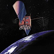
Remote sensing

Along with computers and
"There is no longer any need to preach for aerial photography-not in the United States- for so widespread has become its use and so great its value that even the farmer who plants his fields in a remote corner of the country knows its value."
Remote sensing technology again advanced rapidly during World War II, and the techniques employed were rapidly assimilated as aids in geographical studies.[57] During the Cold War, advancements in photography, aircraft, and rockets only increased the effectiveness of remote sensing techniques.[58] As the technology became available to the general public, geographers were soon overwhelmed with large volumes of satellite and aerial images. New techniques were required to store, process, analyze, and use this new data source, birthing remote sensing scientists.[58]
Computer cartography and GIS
.png)
Coinciding with the quantitative revolution was the emergence of early computers. The interdisciplinary nature of geography forces geographers to look at developments in other fields, and geographers tend to observe and adapt technological innovations from other disciplines rather than developing unique technologies to conduct geographic studies.
...if geographers reject GIS then it could fundamentally affect the outside world's perception of what geography is all about. Certainly, these external perceptions may well be based on a picture of geography as it once was, but nevertheless they cannot be ignored. "How could they be so foolish as to disown the very core of their discipline?"
With the emergence of GIS, researchers rapidly began to explore methods to use the technology for various geographic problems.[64][63] This led some geographers to declare the study of these methods their own science within geography.[64]
Global Positioning System

In 1978 the United States military launched the first satellites to enable the modern Global Positioning System, and the system's full capability was made available to the general public in 2000.[65] This facilitated a level of rapid acquisition of spatial coordinates that previously would have been prohibitively expensive. Geographers began studying methods and applications for this data.[1][66]
New Subdisciplines
During the quantitative revolution, several terms originated from the concept that the technologies developed during this period are a focus of independent study.[55] These terms all overlap to some degree, but at least one study indicates they differ substantially enough to continue using.[55] This rush to create new terms may have been detrimental to their popularity, and the researchers proposing them are considered to have possibly been careless or hasty.[55] This has led to some confusion, and properly defining the areas covered by each term is an active field of research.[55] One paper on the topic stated the following:
With the appearance of the next new technologies, immediately, new proposals of new sciences, new subdisciplines, appear. Many authors with great ease announce the origination of a new science, frequently not caring for the proper justification of its name definition. The old definitions, developed in the context of previous technological conditions, remain in the shadow of new technologies, and are not modernised. The lack of specific terminological conditions, determined boundaries, or scopes of such definition use, encourages one to define the next terms, and the next science and research disciplines.
Quantitative geography
During the early days of the quantitative revolution, the term quantitative geography emerged as a subdiscipline within technical geography, focusing exclusively on these quantitative methods for handling spatial data.[67][68][69] This part of technical geography focuses on spatial statistics and visualizing spatial information, emphasizing quantitative data and the scientific method.[1][70]
Geomatics
In 1960, Bernard Dubuisson coined the term "géomatique" in French. Today, it is defined by the
Geoinformatics
In the late 1980s, the term geoinformatics was coined by Swedish scientist Samuelson and later defined in the 1990s as "the science of integrating four technologies: GIS, remote sensing, photogrammetry and cartography."[55] It was later defined by geographer Michael DeMers as "the science of spatial data processing functions by computer systems."[55][72] This term has been described as being outside the branch of geography entirely and instead placed fully under the discipline of computer science,[55] while other sources place it under the branch of technical geography.[15] Sources have noted that there is no universally accepted definition of geoinformatics.[55]
Geographic Information Science
In the 1990s, the term Geographic Information Science (GIScience) was coined and popularized in the United States by geographer Michael Frank Goodchild to describe "the subset of information science that is about geographic information."[73][55][64] GIScience is mentioned explicitly as being separate from quantitative geography,[67] but under the branch of technical geography.[15][74] In 1995, the University Consortium for Geographic Information Science (UCGIS) was established in the United States to support the field of GIScience, such as the creation of a "model curricula" by geographer Duane Marble to help educators teach GIScience.[75][76] There has been significant debate around the term GIScience, including questioning if it can be considered a science.[77] Many geographers, including Michael Goodchild, continue to advance the use of the term today.[55]
Emergence of critical geography
In the same 1749 publication in which Cave discussed technical geography, critical geography was considered an important part of the process within geography to correct errors on maps and other products to improve models of the world.[7] In the 1970s, critical geography took on the framework of critical theory and Marxist philosophy, and became an umbrella uniting various theoretical frameworks in geography, including Marxist geography, feminist geography, and radical geography[78][79] In response to the ideas and philosophies advanced during the quantitative revolution, particularly positivism, the term critical geography was applied to ideological and theoretical criticisms of the methods and ideas of technical geographers.[42][80] Other geographers have criticized that geography has moved away from the abstract, unquantifiable aspects of place that are essential to the understanding of geography.[81]
In the history of geography since the quantitative revolution, theorists from critical geography are often viewed as in direct confrontation with those of technical and quantitative geography.[82] Some geographers argue that the rise in popularity of critical geography was largely due to the difficulty in learning the emerging novel technologies.[67][83][84] Some geographers argue that many of the early criticisms brought forward by critical geography of quantitative methods have been addressed with advances in technology, and persist due to ignorance of quantitative geography.[67] Critical geography has also been referred to as antiscience.[67][84]
21st century
As these new technologies and methods are widely applicable to various disciplines, concern grew among geographers that these other non-geographers in other disciplines might become better at using them than geographers.[1] In response to this, in 2006 the peer-reviewed journal Geographia Technica was established to serve as an outlet for research employing quantitative, technical, and scientific methods within geography.[1][85][28]
In a 2016 paper within this journal, Ionel Haidu stated:
"The risk is that non-geographers mastering these methods analyze the spatiotemporal data and information better than the geographers. That is why the need to deal with competition induced by other sciences claiming the geographic space as their subject of study and research becomes a serious challenge for geographers. Geographers need to test and adapt to the new methods, models and procedures and implement them in all fields and development trends of Geography. By these also, Technical Geography as a new line of research and professional training becomes a necessity."
— Ionel Haidu, [1]
Technical geography as a concept re-emerges to correct the historical trend in geography of adapting rather than developing new methods, technologies, and techniques for conducting geographic research by encouraging trained geographers to pursue this line of inquiry.[1][12] While the use of the term "technical geography" itself has been debated since at least the 1700s, concepts within technical geography are often separated from the rest of geography when organizing and categorizing subfields in the discipline.[7] Terms such as "techniques of geographic analysis",[86] "geographic information technology",[87] are used synonymously with the term within textbooks.
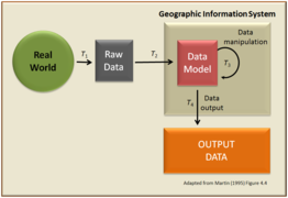
Geographic information science and technology body of knowledge
As technology such as GIS began to dominate geography departments, the need to develop new curriculum to teach the fundamental concepts became apparent.
UNESCO Encyclopedia of Life Support Systems
In 2009, UNESCO Encyclopedia of Life Support Systems employed the term technical geography to organize their literature related to geography, establishing a three-branch model of technical, human, and physical geography, referring to human and physical as the primary two.[2][3][6][53] The benefit of this wording is that it is consistent with the other two branches and clearly places the discipline within geography.[93] The categorization of technical geography as a branch is expanded upon by Ionel Haidu in his 2016 paper.[1]
Sub-branches
- Technical geography can be divided into many broad categories, such as:
-

-

-
-
-

-

-
-

-

-


Techniques and tools
- Technical geography employs, and has developed, many techniques and technologies, such as:
-

-
 Digital mapping
 -
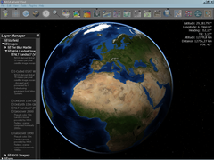
 Geographic information systems
 -

-

-
-

-

-

-


Controversy and criticism
Subdividing any discipline is a difficult matter, and geography is no exception.
More controversially, others deny the idea that the thought and techniques of geography constitute a new branch. This argument asserts that geography must be applied and, therefore, must focus on some subset of human or physical geography.[103] They also argue that there is not enough well-established peer-reviewed literature to back the term as a new branch.[103]
Some have brought allegations that technical geography has introduced gender bias into geography departments as the discipline is disproportionately practiced by men and seen by some as more masculine.[80][104]
Publications
- Annals of the American Association of Geographers
- Applied Geography
- The Professional Geographer
- Geographical Bulletin
- Geographia Technica – journal focused exclusively on technical geography
- ISPRS International Journal of Geo-Information
- Journal of Maps
- Remote Sensing of Environment
Academic programs
Many academic institutions use, or have historically used, the term "technical geography" to either sub-divide their department or describe courses and content offered within their department. These include, but are not limited to:
- Babeș-Bolyai University[92]
- California State University, Long Beach[105]
- Century College[106]
- College of DuPage[107]
- Everett Community College[108]
- Grossmont College[109]
- Jacksonville University[110]
- Oregon State University[31]
- South Dakota State University[90]
- Southern Utah University[111]
- Tennessee State University[112]
- University of Mary Washington[113]
- University of Maryland[89]
- University of Peshawar[114]
- University of Saskatchewan[115][116][117]
- University of South Alabama[118][119]
- Portland Community College[91]
- Weber State University[120]
Influential geographers
- Anne Kelly Knowles – influential in the use of GIS and geographic methods in History.[121]
- Arthur Getis – influential in spatial statistics[122]
- Cynthia Brewer – cartographic theorist that created the web application ColorBrewer[123]
- Ferjan Ormeling Jr. – Dutch cartographer who wrote the UNESCO Encyclopedia of Life Support Systems chapter on Technical Geography.[53]
- George F. Jenks – influential in computer cartography and thematic mapping[124][125]
- Ibn al-Faqih – Wrote Kitab al-Buldan (Ya'qubi book).[21]
- Mark Monmonier – cartographic theorist that wrote numerous books contributing to geographic information systems.[126]
- Mei-Po Kwan – geographer that coined the Uncertain geographic context problem and the Neighborhood effect averaging problem. [127][128]
- Michael DeMers – geographer that wrote numerous books contributing to geographic information systems[127][129]
- Michael Frank Goodchild – GIS scholar and winner of the RGS founder's medal in 2003.[55][64]
- Roger Tomlinson – the primary originator of modern geographic information systems.[130]
See also
- Areography (geography of Mars)– Delineation and characterization of Martian regions
- Concepts and Techniques in Modern Geography – Series of geography publications
- History of cartography
- Map communication model
- Neogeography – Amateur-focused geography
- Planetary science – Science of planets and planetary systems
- Scientific Geography Series – Series of geography publications
- Technical communication – Field of communication of technical information
- Technical drawing – Creation of standards and the technical drawings
- Technical writing – Type of written communication
Notes
- ^ While Cave published the "Geography reformed: a new system of general geography, according to an accurate analysis of the science in four parts", how much he wrote or edited is unclear. Other authors are not given within the text.
- ^ The 1917 English review article is unclear on what was included in these British technical geography courses.
References
- ^ .
- ^ ISBN 978-1-84826-960-6.
- ^ ISBN 978-3-030-78144-6.
- doi:10.36962/GBSSJAR/59.3.004 (inactive 31 January 2024).)
{{cite journal}}: CS1 maint: DOI inactive as of January 2024 (link - ISSN 2163-5900. Retrieved 4 August 2023.
- ^ a b c Sala, Maria (2009). GEOGRAPHY – Vol. I: Geography (PDF). EOLSS UNESCO. Retrieved 30 December 2022.
- ^ a b c d e f g h Cave, Edward (1749). Geography reformed: a new system of general geography, according to an accurate analysis of the science in four parts. The whole illustrated with notes (2 ed.). London: Edward Cave.
- S2CID 260653708.
- .
- ^ Boehm, Richard G.; Peters, Samantha (2008). Careers/Jobs in Geography:Business Cards of Department Graduates (PDF) (sixth ed.). Texas State University San Marcos. Retrieved 8 November 2023.
- ISBN 9781107469846.
- ^ ISBN 0299100707.
- ISBN 978-3-319-78998-9.
- .
- ^ .
- ISSN 1790-3769. Retrieved 24 January 2015.
- ^ Frenz, Thomas. "Tutorials in the History of Cartography – Overview". Archived from the original on 6 July 2006.
- ISBN 0-7748-0444-0. Retrieved 4 January 2024.
- ISBN 9780190670498. Retrieved 20 March 2024.
- ^ ISBN 978-0-08-044911-1. Retrieved 29 January 2024.
- ^ ISBN 978-90-04-51337-2. Retrieved 14 December 2023.
- ^ JSTOR 2560596. Retrieved 1 February 2023.
- ^ "Art of Teaching". School and Home Education. 9 (1): 108. September 1889. Retrieved 4 January 2024.
- JSTOR 196643. Retrieved 24 March 2024.
- . Retrieved 1 February 2023.
- ^ a b Hubbard, George D. (1908). "College Geography". Educational Review: 381–400. Retrieved 4 January 2024.
- ^ JSTOR 199630. Retrieved 18 January 2024.
- ^ a b "Technical Geography – an International Journal for the progress of Scientific Geography: Aims and Scopes". Geographia Technica. "Geographia Technica" Association. Retrieved 1 January 2023.
- ^ ISBN 0582988845.
- ProQuest 2421484. Retrieved 1 February 2023.
- ^ a b Jensen, J. Granville (1990). "Geography at Oregon State University". Association of Pacific Coast Geographers Yearbook (PDF). pp. 153–164. Retrieved 29 September 2023.
- ^ "The 'Quantitative Revolution'", GG3012(NS) Lecture 4, University of Aberdeen, 2011, webpage:AB12.
- ^ Gregory, Derek; Johnston, Ron; Pratt, Geraldine; Watts, Michael J.; Whatmore, Sarah (2009). The Dictionary of Human Geography (5th ed.). US & UK: Wiley-Blackwell. pp. 611–12.
- ^ JSTOR 2560899. Retrieved 30 January 2023.
- ^ .--as cited in Johnston, Ron and Sideway James (2016). Geography and Geographers: Anglo-American Human Geography since 1945 (7th ed). New York: Routledge.
- JSTOR 1790251. Retrieved 30 December 2022.
- JSTOR 2561120.--as cited in Johnston, Ron and Sideway James (2016). Geography and Geographers: Anglo-American Human Geography since 1945 (7th ed). New York: Routledge.
- .--as cited in Johnston, Ron and Sideway James (2016). Geography and Geographers: Anglo-American Human Geography since 1945 (7th ed). New York: Routledge.
- .--as cited in Johnston, Ron and Sideway James (2016). Geography and Geographers: Anglo-American Human Geography since 1945 (7th ed). New York: Routledge.
- ^ Hartshorne, Richard (1959). Perspective on the Nature of Geography. Chicago: Rand McNally.--as cited in Johnston, Ron and Sideway James (2016). Geography and Geographers: Anglo-American Human Geography since 1945 (7th ed). New York: Routledge.
- . Retrieved 4 April 2024.
- ^ a b Crampton, Jeremy W.; Krygier, John (2005). "An Introduction to Critical Cartography". ACME: An International Journal for Critical Geographies. 4 (1). Retrieved 30 January 2023.
- ^ Johnston, Ron; Sidaway, James (2016). Geography & Geographers: Anglo-American Human Geography since 1945 (7th ed.). New York: Routledge. pp. 64–76.
- ^ Gregory, Derek; Johnston, Ron; Pratt, Geraldine; Watts, Michael J.; Whatmore, Robert (2009). The Dictionary of Human Geography (5th ed.). USA & UK: Wiley-Blackwell. pp. 611–12.
- ISBN 978-1-84826-960-6.
- ISBN 9781412919913. Retrieved 27 April 2023.
- S2CID 233620037.
- ^ S2CID 34085823. Archived from the original(PDF) on 8 March 2019. Retrieved 22 July 2022.
- ^ S2CID 33201684. Retrieved 10 March 2022.
- ^ S2CID 17912938.
- ^ Arbia, Giuseppe; Benedetti, R.; Espa, G. (1996). ""Effects of MAUP on image classification"". Journal of Geographical Systems. 3: 123–141.
- ^ Smith, Peter (2005). "The laws of geography". Teaching Geography. 30 (3): 150.
- ^ ISBN 978-1-84826-960-6.
- S2CID 7501501. Retrieved 25 January 2024.
- ^ .
- ^ a b Bagley, James (1941). Aerophotography and Aerosurverying (1st ed.). York, PA: The Maple Press Company.
- ^ Walker, F. (1953). Geography from the Air (1 ed.). London: Methuen & Co. LTD.
- ^ ISBN 978-0-13-405816-0.
- JSTOR 212211. Retrieved 10 March 2022.
- ^ Fitzgerald, Joseph H. "Map Printing Methods". Archived from the original on 4 June 2007. Retrieved 9 June 2007.
- ^ "The 50th Anniversary of GIS". ESRI. Retrieved 18 April 2013.
- .
- ^ S2CID 131571153.
- ^ .
- S2CID 838848.
- S2CID 215889035.
- ^ ISBN 978-0-7619-5948-9.
- S2CID 213700891. Retrieved 3 February 2023.
- . Retrieved 3 February 2023.
- S2CID 130940338. Retrieved 7 January 2023.
- ^ ISO/TR 19122:2004(en) Geographic information/Geomatics — Qualification and certification of personnel [1]
- ISBN 978-0-470-12906-7.
- ISBN 9780203009543.
- ISBN 9781439886885. Retrieved 16 March 2024.
- ^ "History". University Consortium for Geographic Information Science. Retrieved 8 January 2024.
- ^ ISBN 978-0-89291-267-4.
- S2CID 27150014. Retrieved 20 January 2024.
- doi:10.1068/a3263.
- S2CID 128738768.
- ^ . Retrieved 7 January 2023.
- JSTOR 215179. Retrieved 5 January 2023.
- ISBN 978-3-319-53825-9.
- S2CID 144335512.
- ^ a b Graf, W. (1998). "Why Physical Geographers Whine so Much". The Association of American Geographers' Newsletter. 33 (8).
- ^ "Geographia Technica Volume 1" (PDF). Geographia Technica. 1 (2). 2006. Retrieved 1 January 2023.
- ^ ISBN 978-1-259-57000-1.
- ^ ISBN 978-0321843333.
- ISBN 978-0-309-05199-6. Retrieved 21 May 2023.
- ^ a b "Department of Geographical Sciences: Course list". University of Maryland. Retrieved 28 January 2023.
- ^ a b "Geography and Geospatial Sciences: Undergraduate Program – Geography". South Dakota State University. Retrieved 28 January 2023.
- ^ a b "Technical Geography Courses". Portland Community college. Retrieved 28 January 2023.
- ^ a b Man, Titus. "Faculty of Geography". Babeș-Bolyai University. Retrieved 5 July 2023.
- ^ Lemmens, Mathias (April 2001). "Education: Surveying the Issues". Surveying World: 36–38.
- S2CID 128681685.
- ^ . Retrieved 27 August 2022.
- ^ S2CID 243866306.
- ^ ISBN 0-203-00954-1.
- ISBN 81-7450-518-0.
- S2CID 131269013.
- ISBN 0761959483.
- ISBN 9780470659632.
- ISBN 0-470-87154-7.
- ^ a b Collins, Eric (15 February 2016). "What is the Difference Between Geomatics and Geography?". Geomatics Canada. Retrieved 7 January 2024.
- ^ Pujol, Hermínia; Ramon, M. Dolors Garcia; Ortiz, Anna (2012). "Academic careers in Spanish geography: a gender perspective". Boletín de la Asociación de Geógrafos Españoles. 59: 465–467.
- ^ "Department of Geography". California State University, Long Beach, Geography, Archive. Retrieved 29 September 2023.
- ^ "Geography". Century College. Retrieved 29 September 2023.
- ^ "Geography Program: Degrees". College of DuPage. Retrieved 11 October 2023.
- ^ "Geography". Everett Community College. Retrieved 11 October 2023.
- ^ "Careers in Geography". Grossmont College. Retrieved 11 October 2023.
- ^ "Environmental Planning: Available Minors". Jacksonville University. Retrieved 25 November 2023.
- ^ "Geography at SUU". Southern Utah University. Retrieved 29 September 2023.
- ^ "Geography Minor". Tennessee State University. Retrieved 29 September 2023.
- ^ "Geography". University of Mary Washington. Retrieved 29 September 2023.
- ^ "introduction". Department of Geography and Geomatics (GIS and Remote Sensing). University of Peshawar. Retrieved 30 January 2024.
- ^ "U of Saskatchewan to U of Regina". transfer credits. University of Regina. Retrieved 30 January 2024.
- ^ "Bachelor of Science Four-year (B.Sc. Four-year)". Geology. University of Saskatchewan. Retrieved 30 January 2024.
- ^ Petroniro, Elise (2006). "Mosquitoes and Map Design" (PDF). Cartouche:Newsletter of the Canadian Cartographic Association. 64: 8. Retrieved 30 January 2024.
- ^ "Geography Advising Guide". University of Southern Alabama. Retrieved 29 September 2023.
- ^ "GEO Curriculum". University of Southern Alabama. Retrieved 29 September 2023.
- ^ "Geography". Weber State University. Retrieved 29 September 2023.
- ^ "Faculty page at U of Maine Dept of History". Archived from the original on 2015-12-08. Retrieved 2015-12-03.
- S2CID 250510161.
- . Retrieved 2 February 2024.
- ^ ISBN 0-9643841-1-6. Retrieved 24 January 2024.
- .
- ^ "On the Eve of Retirement, Mark Monmonier Receives Lifetime Achievement Award". Syracuse University Media, Law & Policy. May 12, 2021. Retrieved May 12, 2022.
- ^ a b "Previous Anderson Medal of Honor Recipients". American Association of Geographers Applied Geography Specialty Group!. Retrieved 31 March 2023.
- ^ "MEI-PO KWAN (2022 WINNER)" (PDF). American Association of Geographers. Retrieved 11 February 2024.
- ^ "MICHAEL DEMERS (2010 WINNER)" (PDF). American Association of Geographers. Retrieved 11 February 2024.
- ^ Greiner, Lynn (17 December 2007). "Putting Canada on the map: Father of digitized mapping recounts how a stroke of luck led him to develop the world's first geographic information system". The Globe and Mail.
- S2CID 226747451. Retrieved 13 January 2024.
- ISBN 978-0226152127. Retrieved 5 February 2024.
| Branches |
| ||||||||
|---|---|---|---|---|---|---|---|---|---|
| Techniques and tools |
| ||||||||
| Institutions | |||||||||
| Education | |||||||||