
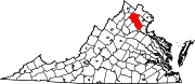
The Plains, Virginia
The Plains, Virginia | ||
|---|---|---|
_at_Virginia_State_Route_55_(Main_Street)_in_The_Plains,_Fauquier_County,_Virginia.jpg) The center of town | ||
|
FIPS code 51-78192[5] | | |
| GNIS feature ID | 1496309[6] | |
| Website | www | |
The Plains is a small incorporated town in Fauquier County, Virginia, United States. The population was 245 as of the 2020 census,[7] up from 217 at the 2010 census.[8] It is centered on the intersection of VA 55 (John Marshall Highway) and VA 245 (Old Tavern Road). The town of The Plains is situated off I-66. As of 2022, the mayor of The Plains is Lori Sisson.[9]
History
In the 18th century, the Colony of Virginia progressively expanded westward and allowed Europeans to begin to construct settlements in the area. Before and during the Civil War, the area was called "White Plains" on maps and a Post Office was named "The Plains" in 1831. A two-story house, with a blacksmith's shop above, was built in 1852. During the Civil War, John S. Mosby and his Mosby's Raiders used The Plains as part of their raiding area they controlled.[10] The Plains was incorporated as a town in 1910.[11]
Geography
The Plains is located in northeastern Fauquier County at 38°51′46″N 77°46′32″W / 38.86278°N 77.77556°W (38.862698, -77.775464).[12] VA 55 leads southeast 10 miles (16 km) to Gainesville and west 4.5 miles (7.2 km) to Marshall. VA 245 leads southwest 1 mile (1.6 km) to I-66 at Exit 31. I-66 leads east 45 miles (72 km) to Washington, D.C., and west 24 miles (39 km) to Front Royal.
According to the United States Census Bureau, the town has a total area of 0.3 square miles (0.7 km2), all of it land.[8]
Climate
The climate in this area is characterized by hot, humid summers and generally mild to cool winters. According to the
Demographics
| Census | Pop. | Note | %± |
|---|---|---|---|
| 1920 | 275 | — | |
| 1930 | 414 | 50.5% | |
| 1940 | 372 | −10.1% | |
| 1950 | 405 | 8.9% | |
| 1960 | 484 | 19.5% | |
| 1970 | 418 | −13.6% | |
| 1980 | 382 | −8.6% | |
| 1990 | 219 | −42.7% | |
| 2000 | 266 | 21.5% | |
| 2010 | 217 | −18.4% | |
| 2020 | 245 | 12.9% | |
| 2022 (est.) | 239 | [14] | −2.4% |
| U.S. Decennial Census[15] | |||
As of the
There were 110 households, out of which 25.5% had children under the age of 18 living with them, 44.5% were married couples living together, 14.5% had a female householder with no husband present, and 35.5% were non-families. 31.8% of all households were made up of individuals, and 10.9% had someone living alone who was 65 years of age or older. The average household size was 2.42 and the average family size was 3.01.
In the town, the population was spread out, with 21.1% under the age of 18, 5.6% from 18 to 24, 32.0% from 25 to 44, 26.3% from 45 to 64, and 15.0% who were 65 years of age or older. The median age was 42 years. For every 100 females, there were 91.4 males. For every 100 females aged 18 and over, there were 85.8 males.
The median income for a household in the town was $43,750, and the median income for a family was $45,313. Males had a median income of $41,250 versus $33,542 for females. The
Attractions
The Plains is home to
Archwood Green Barns Farmer's Market features fresh, homemade and local products. Hours are Sunday, 10:00 a.m. to 3:00 p.m. beginning the last Sunday in April through the 2nd Sunday in November. It is open the first two Sundays in December for the "Christmas on the Farm" show.
A museum exhibit, "Footprint to Change", is located at 4243 Loudoun Avenue near the train tracks that go through town. The building houses the Afro-American Historical Association of Fauquier County offices, library and archives as well as the museum.[17]
Long Branch Baptist Church (est. 1786), the third oldest
Wakefield School, a pre-school through Grade 12 independent school, is located just south of the town limits.
Actor Robert Duvall once owned a restaurant in The Plains called "The Rail Stop", named after the Norfolk Southern B-Line, which runs through the town. He still makes his residence north of town at his 360-acre (1.5 km2) Byrnley Farm.[18] The town is also home to a seasonal corn maze owned and operated by a family in Charlottesville.
The National Association of Rocketry held NARAM-50 there in the summer of 2008.
The Masonic lodge was organized on a site near the present post office. The Plains Lodge U.D. held its first meeting on December 29, 1898, and continued to work "Under Dispensation" until the Grand Lodge of Virginia met in Alexandria on December 15, 1899, and issued the lodge a charter under the name of Cochran Lodge No. 271.
Transportation
Highways directly serving The Plains include Virginia State Route 55 and Virginia State Route 245. SR 55 extends east and west, serving as a local service road to nearby I-66, while SR 245 provides the most direct connection to I-66 from The Plains.
Gallery
-
 View east along SR 55 approaching SR 245
 -
 Carter Hotel next to Norfolk Southern RR tracks
 -
 Old High School at west end of town
 -
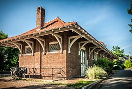 Train depot - brick
 -
 Train depot - frame
 -
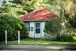 Former jail
_between_Stuart_Street_and_Bragg_Street_in_The_Plains,_Fauquier_County,_Virginia.jpg)


See also
References
- ^ "The Plains, Virginia - Town Council".
- ^ "2019 U.S. Gazetteer Files". United States Census Bureau. Retrieved August 7, 2020.
- ^ "Explore Census Data".
- ^ "The Plains, Virginia Population 2022 (Demographics, Maps, Graphs)".
- ^ a b "U.S. Census website". United States Census Bureau. Retrieved January 31, 2008.
- ^ "US Board on Geographic Names". United States Geological Survey. October 25, 2007. Retrieved January 31, 2008.
- ^ "Explore Census Data". data.census.gov. Retrieved May 17, 2022.
- ^ a b "Geographic Identifiers: 2010 Demographic Profile Data (G001): The Plains town, Virginia". U.S. Census Bureau, American Factfinder. Retrieved October 18, 2016.[dead link]
- ^ "The Plains, Virginia - Town Council". theplainsvirginia.org. Retrieved May 17, 2022.
- ^ "About Us - Our History". theplainsvirginia.org. Retrieved May 30, 2022.
- ^ Audrey Hoffer (November 21, 2014). "Where We Live: The Plains, Va., is a historic rural enclave works to stay that way". The Washington Post. Retrieved May 30, 2022.
- ^ "US Gazetteer files: 2010, 2000, and 1990". United States Census Bureau. February 12, 2011. Retrieved April 23, 2011.
- ^ Climate Summary for The Plains, Virginia
- ^ "The Plains, Virginia Population 2022 (Demographics, Maps, Graphs)".
- ^ "Census of Population and Housing". Census.gov. Retrieved June 4, 2015.
- ^ Ridgway-Khalifa, Daisy (March 21, 2012). "A Day in the Country". Virginia Living. Cape Fear Publishing. Retrieved June 27, 2016.
- ^ "Virtual Museum". Footsteps to Change. Afro-American Historical Association of Fauquier County. Retrieved November 20, 2013.
- ^ "Robert Duvall at home in rural Virginia".
- ^ "National Register Information System". National Register of Historic Places. National Park Service. July 9, 2010.
- ^ "NRHP nomination for The Plains Historic District" (PDF). Virginia DHR. Retrieved June 6, 2014.
- ^ "NRHP actions taken, 5/26/14 through 5/30/14". National Park Service. Retrieved June 6, 2014.
External links
- Town of The Plains official website
- virginia.org website
- Great Meadows
- Virginia Gold Cup
- Fauquier County tourism website
- Cochran Lodge No. 271 A.F. & A.M.
 | ||||
| CDPs | ||||
| Other communities | ||||
| Footnotes | ‡This populated place also has portions in an adjacent county or counties | |||
| ||||

| International | |
|---|---|
| National | |