
Titiwangsa Mountains
| Titiwangsa Mountains | |
|---|---|
| Banjaran Titiwangsa/Besar ( | |
| Range coordinates | 5°58′12″N 101°19′37″E / 5.9699°N 101.3269°E |
| Parent range | Tenasserim Hills |
| Geology | |
| Age of rock | Permian and Triassic |
| Type of rock | Granite and limestone |

The Titiwangsa Mountains (Malay: Banjaran Titiwangsa; Jawi: بنجرن تيتيوڠسا, pronounced [ˈband͡ʒaˈran titiwaŋˈsa]), also known as Banjaran Besar (lit. 'main range') by locals, is the chain of mountains that forms the backbone of the Malay Peninsula. The northern section of the range is in southern Thailand, where it is known as Sankalakhiri Range (Thai: ทิวเขาสันกาลาคีรี; RTGS: Thio Khao Sankalakhiri; pronounced [tʰīw kʰǎw sǎn.kāːlāːkʰīːrīː]).
The mountain range acts as a natural divider, dividing Peninsular Malaysia, as well as southernmost Thailand, into east and west coast regions. It also serves as a drainage divide of some major rivers of Peninsular Malaysia such as the Pahang, Perak, Kelantan, Klang and Muar. The length of mountain range is about 480 km from north to south.
Geology
.jpg)
The Titiwangsa Mountains is part of a
The Cimmeria was separated from
Sibumasu terranes on the other hand, only started to separate from Gondwana during the
Seismic hazards
Between 1984 and 2013, there had been tremors ranging from 1.6 to 4.6 on the
Geography

This mountain range is a part of the wider Tenasserim Hills system. It forms the southernmost section of the Indo-Malayan cordillera which runs from Tibet through the Kra Isthmus into the Malay Peninsula.[7]
The Titiwangsa Mountains proper begins in the north as the Sankalakhiri Range, a prolongation of the
Outcrops of TitiwangsaIn general, the greatest elevations occur along the northern and central sections of the range, with its highest point measuring 2,183 m (7,162 ft) on
Features


 FT 51 in the Negri Titiwangsa near Bukit Putus
The rainforests of the Titiwangsa Mountains form part of the
.jpg)

Several popular
are located on the range.Two of Malaysia's largest metropolitan areas are located along the western fringes of the mountain range, namely
Protected areas
Thailand
- San Kala Khiri National Park
- Budo - Su-ngai Padi National Park
- Bang Lang National Park
- Namtok Sai Khao National Park
- Hala Bala Wildlife Sanctuary
Malaysia
- Gunung Stong State Park
- Selangor State Park
- Kenaboi State Park
- Royal Belum State Park
- Krau Wildlife Reserve
- Kinta Valley National Geopark
- Forest Research Institute Malaysia
In popular culture
The mountain range was the subject of the patriotic song "Titiwangsa", which was first sung by Saloma. Its lyrics glorifies the magnificence and beauty of the Titiwangsa Mountains, and its significance to Malaya as a whole.
Gallery
-
-

-
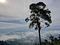
 The Titiwangsa Mountains seen from a .
 -
 The peak of Mount Korbu, the tallest mountain of the range.
 -
 View of Mts.col) from the northern side of Mount Yong Belar
 -
 As viewed from Cameron Highlands
 -
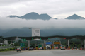
 The Titiwangsa Mountains tower over theNorth-South Expressway in Slim River, Perak.
 -
 View from Fraser's Hill
 -
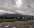
 The eastern flank of the Titiwangsa Mountains, as seen from the East Coast Expressway near Karak, Pahang.
 -

-
 The Titiwangsa Mountains nearKuala Kubu Baru, Selangor.
 -
 The Titiwangsa Mountains near Batang Kali, Selangor.
 -
 As seen from a residential skyscraper in Kuala Lumpur
 -
 The Titiwangsa Mountains seen from the (the mountain with the darker hue), Berembun and Telapak Buruk (background).
 -
 The Titiwangsa Mountains nearKuala Pilah, Negeri Sembilan.
 -
 The southern section of the Titiwangsa Mountains in Kota, Negeri Sembilan. Mount Datuk rises to the east, which is on the right side of the picture.
 -
 Mount Tampin, Negeri Sembilan, the southern terminus of contiguous Titiwangsa Mountains. Taken at Pulau Sebang, Malacca


.jpg)


References
- ISBN 9781862392755. Retrieved 20 June 2019.
- ^ Metcalfe, I., 2000, "The Bentong-Raub Suture Zone", Journal of Asian Earth Sciences, v. 18, p. 691-712
- ^ Metcalfe, I., 2002, "Permian tectonic framework and palaeogeography of SE Asia", Journal of Asian Earth Sciences, v. 20, p. 551-566
- ^ Ada kebarangkalian gempa bumi berlaku di Malaysia - NRECC astroawani.com 19 April 2023
- ^ "Earthquakes in Malaysia: Should we be worried and how to reduce its impact on our buildings?". 12 January 2022.
- ^ "Gempa bumi: Rujuk peta bahaya seismik sebelum reka bangunan". 2 May 2023.
- ISBN 978-0-19-924802-5
- ^ "Places of Interest | Official Portal of Tampin District Council (MDT)". Mdtampin.gov.my. 1941-01-14. Retrieved 2023-04-04.
- ^ "(PDF) Vegetation of Peninsular Malaysia". Retrieved 3 March 2024.
- ^ "Empat kawasan di Melaka berpotensi diiktiraf Geopark Kebangsaan". Astro Awani. 2023-10-22.
- ^ "Gunong Ulu Titi Basah, Thailand - Geographical Names, map, geographic coordinates". geographic.org. Retrieved 3 March 2024.