
Veghel
Veghel | |
|---|---|
Town and Former municipality | |
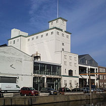
     _War_memorial.JPG)   From top down, left to right: market square of Veghel, former cantonal court and town hall, Klondike villa, Sacred Heart statue, Wiebenga silo, Airborne Monument, Saint Lambert Church, former Synagogue of Veghel | |
|
UTC+2 (CEST) | |
| Postcode | 5460–5469 |
| Area code | 0413 |
| Website | www |


Veghel (Dutch pronunciation: [ˈvɛɣəl] ⓘ) is a town and a former municipality in the southern Netherlands. On 1 January 2017 Veghel, together with Schijndel and Sint-Oedenrode, merged into a new municipality called Meierijstad creating the largest municipality of the province North-Brabant in terms of land area.[3]
History
The first settlements date back to
In 1310, John II of Brabant granted the inhabitants the right to use common grounds. For some decades in the 16th and 17th century the municipality was ruled by the Lords Van Erp, residing at their castle of Frisselsteijn in Veghel.
In 1648 Veghel became part of the
In 1719 Veghel became a
In 1940 Veghel was occupied by
The period since the 1950s has seen much growth, with the development of new industries and the establishment in Veghel of several international companies (e.g.
Since 1994, Veghel and the neighbouring town of Erp have formed a single municipality.
Demographics
Towns
Population figures as of 1 January 2015, ranked by size:[4]
| Town | Population | Density |
| Veghel (nl) | 31,032 | 730/km2 |
| Erp | 6,743 | 189/km2 |
Population centres
Population figures as of 1 January 2015, ranked by size:[4]
| Urban core | Population | Density |
| Veghel | 26,491 | 1063/km2 |
| Erp | 4,761 | 239/km2 |
| Zijtaart | 1,727 | 173/km2 |
| Mariaheide | 1,449 | 355/km2 |
| Eerde | 1,365 | 387/km2 |
| Keldonk | 1,204 | 112/km2 |
| Boerdonk | 778 | 157/km2 |
Language
The language spoken by the native population is North Meierijs (an East Brabantian dialect, which is very similar to colloquial Dutch).[5]
Nationalities
Compared to other towns in the region, the ethnic makeup of Veghel is relatively diverse.[6] More than 22% of the town's population, or 17% of the municipality's population, is of foreign origin.[7] In total, Veghel is home to people of more than a hundred different nationalities.[8] About 90% of the municipality's total foreign population lives inside the town proper of Veghel.[9]
| Largest foreign ethnic groups (2015)[7][8] | |
| Nationality | Population |
|---|---|
| 1,457 | |
| 806 | |
Indonesians |
662 |
| 585 | |
| 526 | |
| 372 | |
| 181 | |
| 167 | |
| 149 | |
| 139 | |
| 121 | |
| 100 | |
Local festivals
Every November sees the celebration of the entry of St Nicholas (Sinterklaas). Every two years in June or July, the Slokdarmfestival takes place. On 1 September the harbour festival takes place. In February or March the traditional carnival is held.
Attractions
- The neogothic church of St Lambert and its graveyard containing war graves
- The neorenaissance former town hall
- The neogothic former synagogue (recently rebuilt)
- The Protestant church
- The monastery of the Franciscan Sisters of the Immaculate Conception from the Holy Mother of God with its gardens and church
Notable residents
- Anky van Grunsven, dressage champion.
- Dillianne van den Boogaard, former Netherlands international field hockey player.
- Earnie Stewart, former United States international soccer player.
- Theo Lucius, former professional footballer for PSV Eindhoven and Feyenoord.
- Theo Maassen, comedian and actor.
- Glenn van Berlo, racing driver.
Twin towns - sister cities
Veghel is
 Goch in Germany
 Pont-Audemer in France
Gallery
-
 Town Hall of Veghel
 -
 Villa Klondike, former headquarters of the 501st Parachute Infantry Regiment (101st Airborne Division)
 -
 Statue of the Sacred Heart of Jesus at the marina square
 -

-

-
-
 Inland port of Veghel
 -
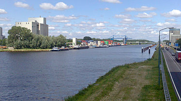 Inland port of Veghel
 -
 Boxtel-Wesel Railway
 -
 Railroad crossing the Aa river
 -

-
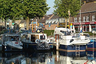 Marina of Veghel
 -
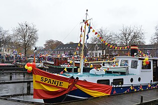 Marina of Veghel during the entry parade of Sinterklaas, 16 November 2014


.JPG)


References
- ^ a b "Kerncijfers wijken en buurten 2021". Central Bureau of Statistics. Retrieved 17 April 2022.
- ^ "Postcodetool for 5461KN". Actueel Hoogtebestand Nederland (in Dutch). Het Waterschapshuis. Retrieved 6 June 2014.
- ^ CBS. "In twintig jaar bijna 240 gemeenten minder". www.cbs.nl (in Dutch). Retrieved 2016-12-30.
- ^ a b "Population per centre as of 01-01-2015". Municipality of Veghel. 1 January 2015. Retrieved 24 April 2015.
- ISBN 9012090105
- ^ "1e + 2e generatie allochtonen (incl. Westerse) per duizend inwoners" [1st & 2nd-generation immigrants (inc. Westerners) per capita]. Brabant databank (in Dutch). Province of North Brabant. 1 January 2014. Retrieved 1 January 2015.
- ^ a b "Kerncijfers voor bevolking; leeftijd, herkomstgroepering, geslacht en regio" [Key figures for population; age, ethnic background, gender and region]. CBS Statline (in Dutch). CBS. 1 January 2015. Retrieved 14 August 2015.
- ^ a b "Buitenlandse nationaliteiten in Veghel per 01-01-2015" [Foreign nationalities in Veghel by 1/1/2015] (in Dutch). Municipality of Veghel. 1 January 2015. Retrieved 1 January 2016.
- ^ "Kerncijfers wijken en buurten 2015" [Key figures for neighbourhoods 2015]. CBS Statline (in Dutch). CBS. 1 January 2015. Retrieved 30 November 2015.
External links
 Media related to Veghel at Wikimedia Commons
- Official website
Places adjacent to Veghel | |
|---|---|
| International | |
|---|---|
| National | |
| Geographic | |