
Amarapura
Amarapura
အမရပူရ | |
|---|---|
Township of UTC6:30 (MST) | |
| Area codes | 2 (mobile: 69, 90)[1] |
Amarapura (
Etymology
Amarapura comes from
History

Amarapura was founded by King
In 1810 the town was estimated to contain 170,000 inhabitants, but in that year it was destroyed by fire.
The ruins of the city wall show it to have been a square with a side of about three-quarters of a mile in length. At each corner stood a solid brick
The indigenous Burmese tradition of
Sights of interest
- Pahtodawgyi (Amarapura) – A stupa built by King Bodawpaya in 1816 outside the city walls
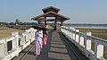
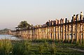
- U Bein Bridge – a 1.2 km (0.75 mi) wooden footbridge (longest teak bridge in the world) built by the mayor U Bein salvaging the unwanted teak columns from the old palace during the move to Mandalay
- Kyauktawgyi Pagoda – A stupa built by King Pagan in 1847 at the farther end of U Bein's bridge
- Amarapura Palace ruins – containing tombs of King Bodawpaya and King Bagyidaw, and part of the old moat
- Maha Gandhayon Monastery– a large modern monastery complex with hundreds of monks and novices, well known throughout the country
- Chinese Temple – built in 1838 during King Tharrawaddy's reign
- Yadanabon University – A major liberal arts university for students from Mandalay suburbs
- Nagayon Temple
- Mandalar Degree College – One of tourism and hospitality management college which co-operated with liberal arts major and well known for its diversities and students from different province.
Photos
-
 Monks Crossing U Bein Bridge at Sunset
 -
 U Bein Bridge across the Taungthaman Lake
 -
 Buddhist monks on U Bein Bridge
 -
 U Bein Bridge
 -
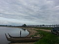
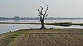 Taungthaman Lake, Amarapura
 -
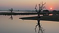 Sunset over Taungthaman Lake
 -
 Old City Gate
 -
 U Bein Bridge, detail
 -
 U Bein Bridge
 -
 A panoramic view of Amarapura looking towards the south-west in 1855 by Colesworthey Grant


Notes
- ^ "Myanmar Area Codes". Archived from the original on 2009-12-01. Retrieved 2009-04-04.
- ^ Arrowsmith, Aaron (1831). A compendium of ancient and modern geography. London, England. p. 637.
- ^ amara = immortality; pūra = city.
- ^ Maung Maung Tin Vol. 1 1905: 395
- ^ Bischoff 1995: 113
- ^ a b c One or more of the preceding sentences incorporates text from a publication now in the public domain: Chisholm, Hugh, ed. (1911). "Amarapura". Encyclopædia Britannica. Vol. 1 (11th ed.). Cambridge University Press. p. 780.
- ^ Maung Maung Tin Vol. 2 1905: 223
- ^ Maung Maung Tin Vol. 3 1905: 33
- ^ Cooler, Konbaung Amarapura
- ^ Maung Maung Tin Vol. 3 1905: 193
- ^ Hardiman, John Percy (1901). Silk in Burma. superintendent, Government printing, Burma.
- ^ "The Tradition of Acheik Weaving in Myanmar – ICHCAP". Retrieved 2020-03-28.
- ^ Lynn, Kyaw Ye. "Weavers of traditional textiles in Mandalay unite". Frontier Myanmar. Retrieved 2020-03-28.
References
- Bischoff, Roger (1995). Buddhism in Myanmar - A Short History (PDF). Kandy: Buddhist Publication Society.
- Cooler, Richard M. "The Konbaung Period - Amarapura". Northern Illinois University. Archived from the original on 16 June 2006. Retrieved 2006-06-09.
- Maung Maung Tin (1905). Konbaung Hset Maha Yazawin (in Burmese). Vol. 1–3 (2004 ed.). Yangon: Department of Universities History Research, University of Yangon.
- Hoke Sein. "Entry for amara". Pāḷi-Myanmar Dictionary (ပါဠိမြန်မာ အဘိဓာန်) (in Burmese). Pali Canon E-Dictionary Version 1.94. Retrieved 15 February 2015.
- Hoke Sein. "Entry for pura". Pāḷi Dictionary (in Burmese). Pali Canon E-Dictionary Version 1.94. Retrieved 15 February 2015.
External links
- Wanderings in Burma George W. Bird, 1897, Southeast Asia Visions
21°54′N 96°03′E / 21.900°N 96.050°E
Capital: Mandalay | ||
| Kyaukse District |   | |
| Mandalay District | ||
| Meiktila District | ||
| Myingyan District | ||
| Nyaung-U District | ||
Pyinoolwin District | ||
| Yamethin District | ||
| Main cities and towns | ||