
Bara-lacha la
| Bara-lacha la | |
|---|---|
Himalaya | |
| Coordinates | 32°45′31″N 77°25′13″E / 32.75861°N 77.42028°E |
 | |
 | |


Bara-lacha la also known as Bara-lacha Pass, or Bārā Lācha La,

The two headwaters of the
The pass also acts as a water-divide between the Bhaga river and the Yunam river.[5]
Legend
Folklore states that the two divine lovers, Chandramukhi, daughter of the
Soon Bhaga was found coming with great struggle through the narrow gorges to Tandi, where consequently, they both met and the celestial marriage was performed. Bhaga covered about 60 km (37 mi) distance, which was very difficult.[6]
Geography
Cross roads from Spiti, Ladakh, Zanskar and Lahaul meet at the Baralacha Pass. In ancient times it was part of a trade route. On the northwest originates the Bhaga River while the Chandra flows south-east. Below the Baralacha-la is an emerald lake, the Suraj tal (Sun lake), the source of the river Bhaga.
"Mr. Shaw thus describes the region:
"The Bara Lacha is the boundary between two separate regions distinguished by their physical characteristics. That which we have already passed through may be called the true Himalayan region. Here the gigantic ranges are covered with perpetual snow, furrowed by glaciers, and they arise from amid dense forests which clothe their flanks up to a certain elevation. They are separated by deep gorges, whose sides are precipices, and though which large rivers flow. In fact the scenery is Alpine.
Henceforward, however, we must bear in mind that we are in the barren or Tibetan region, where green spots are about as rare as islands in the ocean, and universal gravel is the rule."[7]
In popular culture
In Rudyard Kipling's novel Kim, there is a reference to Bara-lacha la pass the source of the Suraj Tal having been used by Kim's Lama to enter India from Tibet.[8]
Tourism and trekking
A trekking route leads from Bara-lacha la to
- Manali (2000 m) - Batal (3907 m) drive
- Batal (3907 m) - Chandrataal (4300 m) hike
- Chandrataal (4300 m) - Tokpo Gongma (4320 m) hike
- Tokpo Gongma (4320 m) - Tokpo Yongma (4640 m) hike
- Tokpo Yongma (4640 m) - Baralacha La (4900 m) - Manali
Gallery
-
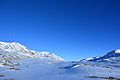 View of Bara-lacha la in June
 -
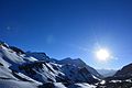 Bright Sunny day at Bara-lacha la
 -
 Bara-lacha la snow-covered mountain
 -
 Baralacha La looking towards Chandra Taal, July 2016


See also
- Geography of Ladakh
- India-China Border Roads
- List of mountain passes of India
References
- ^ Geonames.org. "Bārā Lācha La". Retrieved 6 August 2009.
- ^ "Passes and jots in himachal, alist of 61 passes and jots in himachal".
- ^ "Archived copy". Archived from the original on 6 November 2008. Retrieved 19 November 2008.
{{cite web}}: CS1 maint: archived copy as title (link) - ^ ISSN 0971-5223. Archived from the original(PDF) on 8 June 2012. Retrieved 6 August 2009.
- ^ R. K. Pant; N. R. Phadtare; L. S. Chamyal & Navin Juyal (June 2005). "Quaternary deposits in Ladakh and Karakoram Himalaya: A treasure trove of the palaeoclimate records" (PDF). Current Science. 88 (11): 1789–1798. Retrieved 6 August 2009.
- ^ "Lahaul & Spiti". Archived from the original on 16 April 2019. Retrieved 16 November 2008.
- ^ Central Asia. Travels in Cashmere, Little Thibet and Central Asia. Compared and arranged by Bayard Taylor. New York. Charles Scribner's Sons. 1893, p.107.
- ^ "Manali - Leh Jeep Safari-II". Archived from the original on 2 March 2009. Retrieved 16 November 2008.
- ^ "Chandratal to Baralacha La Trek - AlienAdv.com". 9 June 2021.