
Palakkad Gap
| Palakkad Gap | ||
|---|---|---|
Elevation 140 metres (460 ft) | | |
| Location | Tamil Nadu - Kerala , India | |
| Range | Western Ghats | |
| Coordinates | 10°43′07″N 76°52′55″E / 10.718550°N 76.881966°E | |
  | ||
Palakkad Gap or Palghat Gap is a low
Origin and History


There are various theories about the origin of Palakkad gap. One among them is that it is caused by the landslide due to rivers flowing in opposite directions. The Bharathappuzha river from Pollachi, Tamil Nadu (River Ponnani) flows through the Palakkad Gap, collects water from various rivulets and tributaries feeding from steep escarpment slopes along the flanks of the Ghats.[2] Another theory suggests that the gap may be created by an asteroid strike around 800 million to 550 million years ago.[3]
A study published in 2008 suggest that it is the continuation of a Precambrian shear-zone that extended from east Africa through Ranotsara Gap of Madagascar to Palakkad Gap in India.[4]
Palakkad gap has played a major role in enabling human migration into Kerala from parts of Tamil Nadu. From 300 B.C. to 13th century, it also helped the
There is also another theory which suggest that this Palakkad Gap is formed out due to a massive Astroid attack at Coimbatore Area which leads to the formation of
Effect on weather
The gap affects the weather patterns in Southern India as it allows the moisture-laden
Transport and trade
The gap is the lowest pass through the Western Ghats in the region. It is an important mountain pass in the Western Ghats that runs along the entire eastern edge of Kerala isolating it from the neighboring Tamil Nadu. It acts as an important transport corridor between the two States by linking
Both the
Wind Energy
The Palakkad Gap funnels the winds blowing from the west on to
.See also
- Aryankavu mountain pass.
- Aralvaimozhi
- Palakkad
Gallery
-
 Palghat Gap as seen from Coimbatore-Shoranur railway line
 -
 Palghat Gap as seen from Palghat-Chitoor Road
 -
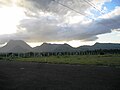
 Western Ghats as seen from Coimbatore-Shoranur rail line
 -
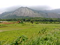
 View of Ghats
 -
 Palghat-CoimbatoreNH 544 - NH 66 (re-numbered NH 47)runs through the gap
 -
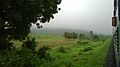
 Southern end of the gap
 -
 One end of the gap
 -
 A passenger train in Palghat gap


References
- ^ "Britannica Encyclopedia". Retrieved 8 March 2015.
- ^ Nair, Dr. S. Sathis Chandran, (20 May 2004). A Note on the Ecological Impact of the Proposed Pathrakkadavu Hydro-Electric Project (PHEP) in the Kunthi River, Palakkad District of Kerala: India - Silent Valley Rainforest Under Threat Once More
- ^ Did an asteroid hit south India millions of years ago?, (19 Jan 2019)Is the land between present day Nilgiris and Kodaikanal located on a crater formed by the impact?
- ISSN 0974-6889.
- ^ "History of Kerala Iyers,migration of Tamil Brahmins to Kerala". www.kuzhalmannamagraharam.info. Retrieved 9 September 2020.
- ^ "Kaveri Crater – An Impact Structure in the Precambrian Terrain of Southern India".
- S2CID 134717819.
- ^ "Tiruppur District Official Webpage". Retrieved 6 November 2013.
- ^ "TamilNadu Energy Development Agency". Archived from the original on 7 November 2013. Retrieved 6 November 2013.
External links
- View of Palghat Gap from the NelliampathyMountain ranges