
Big Thicket
| Big Thicket National Preserve | |
|---|---|
 | |
  | |
| Location | Southeast Texas, U.S. |
| Nearest city | Kountze, Texas |
| Coordinates | 30°32′51″N 94°20′24″W / 30.54750°N 94.34000°W |
| Area | 113,122 acres (457.79 km2)[1] |
| Authorized | October 11, 1974 |
| Visitors | 137,722 (in 2011)[2] |
| Governing body | National Park Service |
| Website | Big Thicket National Preserve |
The Big Thicket
Native Americans are known to have lived and hunted in the area nomadically, but did not establish permanent settlements there before the Alabama–Coushatta settled in the northeast about 1780. Spanish explorers and missionaries generally avoided the area and routed their roads around it. Logging in the late 19th and 20th centuries dramatically reduced the forest concentration. Efforts to save the Big Thicket from the devastation of oil and lumber industries started as early as the 1920s with the founding of the East Texas Big Thicket Association by Richard Elmer Jackson.[6][9]
Conservatively the area occupies all of Hardin County, most of Polk, and Tyler Counties, and parts of Jasper, Liberty and San Jacinto Counties, including areas between the Neches River on the east, the Trinity River on the west, Pine Island Bayou on the south, to the higher elevations and older Eocene geological formations to the north. Broader interpretations have included the area between the Sabine River on the east and the San Jacinto River on the west including much of Montgomery, Newton, Trinity, and Walker Counties, as well.[6][10][11] Several attempts to define the boundaries of the Big Thicket have been made, including a biological survey in 1936 which included over 3,350,000 acres (13,600 km2) covering 14 counties.[12] A later botanical based study in 1972 included a region of over 2,000,000 acres (8,100 km2).[13] This same habitat extends into Louisiana and eastward.[14]
Geography
One's fondness for the area is hard to explain. It has no commanding peak or awesome gorge, no topographical feature of distinction. Its appeal is more subtle.
— Big Thicket Legacy, University of Texas Press, 1977
Physical geography
_of_the_Big_Thicket_Basin_and_the_Epochs_in_which_they_were_formed_(lower_right)._This_is_a_generalized_illustration_and_it_is_not_accurate_in_scale_or_proportion.jpg)
Geology: The Big Thicket is notable for the unusually high diversity of plants concentrated in a relatively small area. A major factor enabling this diversity is an unusually high diversity of soils. The exposed surface soils are relatively recent, late
Soils: The

Topography: The Big Thicket Basin has been described as shallow bowl or dish, tilted to one side, with the high rim on the interior north and low rim on the coastal south. Eastern and western rims consist of the low ridges that divide the Neches River and Sabine River drainages on the east and the Neches River and Trinity River drainages on the west. Elevations range from about 350 feet (110 m) in the north to 25–35 feet (7.6–10.7 m) in the south, dropping as low as 3 feet (1 m) at confluence of the Neches River and Pine Island Bayou. Northern regions are characterized by low gently rolling hills and well-formed drainage systems of streams and creeks in the landscape. The southern regions are comparatively flat, with poor drainage and support moderately extensive
Hydrology: Hardin, Tyler, western Jasper and southeast Polk counties are drained by the
Climate: The proximity to the
Human geography
Population: In 2010, the United States Census Bureau reported a population of 54,635 for Hardin County, with an average of 61.3 inhabitants per square mile (23.7/km2) in a county of 890.5 square miles (2,306 km2). The larger towns (and populations from 2010 census) in Hardin County are Kountze, the county seat (2,123), Lumberton (12,448), Silsbee (6,611), and Sour Lake (1,813). Smaller unincorporated communities in the Hardin County include Batson, Honey Island, Saratoga, Thicket, Village Mills, and Votaw.[20]
Tyler County had a total population of 21,766, with an average population of 23.5 inhabitants per square mile (9.1/km2) in 924.5 square miles (2,394 km2). The larger towns in Tyler County are Chester (312), Colmesneil (596), Warren (757), and Woodville, the county seat (2,586) with smaller unincorporated communities including Doucette, Fred, Rockland, and Spurger.
Polk County had a total population of 45,413, with an average of 43 inhabitants per square mile (17/km2) in an area of 1,057.1 square miles (2,738 km2) in 2010 including Livingston (5,335), the county seat and the largest town in the county.[20]
Larger towns and cities in the greater region include Beaumont, Jefferson County, located at the southeast corner of the Big Thicket area with a population of 118,296 and Liberty, Liberty County (8,397), on the southern edge of the Big Thicket area. Houston, Harris County, with a population of 2,320,268 (greater metropolitan area over 7,000,000) is one of the largest metropolitan areas in the US with its central, downtown area located 75 miles (121 km) by air southwest of the town of Kountze, Hardin County.[20]
Economy: Timber, oil and gas, and agriculture continue to be significant to the economy of the area. Many people commute to work in oil refineries and related industries in the Beaumont area. Other sources list industries providing significant employment in Hardin County as: educational, health and social services, construction, recreation, accommodation and food services, finance, insurance, real estate, and rental and leasing.[20][21]
Biology
It is my observation that the Thicket communicates best with solitary wanderers, but it also speaks to companionable spirits. An important trick on the trail is to shift one's focus from the big scene to the minuscule. Take your time, folks. The Big Thicket is not a hurry-place.
— Maxine Johnston, Foreword in Nature Lover's Guide to the Big Thicket[5]
Ecosystems
On a larger scale of

Uplands (aka: longleaf pine-bluestem uplands;
Sandylands (aka: arid oak-farkleberry sandylands;

Savannas (aka: longleaf - black gum savannahs;

Slope forests (aka: beech-magnolia-loblolly slopes;
_Polk_Co._TX;_12_May_2020.jpg)
Floodplains: (aka: sweet gum - oak floodplains;
Baygalls

Flats (aka: palmetto-oak flats;

Cypress slough
_CR_2077,_Liberty_Co._TX;_22_May_2020.jpg)
Mixed-grass prairies:
_Polk_Co._TX;_12_May_2020.jpg)
Roadsides[6][5] and river edge: Although not a natural or even stable plant assemblage, some have recognized roadsides as an ecosystem in the Big Thicket. Proponents of the concept have identified a number of distinguishing characteristics of roadsides from the other ecosystems. Sunlight and heat can reach the ground along the clear highway easements, unlike most areas where the light is filtered by the forest canopy before it reaches the ground. Roadsides receive more rainwater, diverted from the pavement and often retained for a time in roadside ditches. Soil types not normally found at the surface are often exposed with the construction of roads, particularly deep road cuts in the low hills in the north that expose calcareous soils or where the formations are thin near transition zones supporting the growth of plants not normally occurring in the surrounding habitat, allowing for more diverse plants species to grow. The "corridor effect"[6] of traffic, both human (vehicles, tourists, and road crews) and birds and other animals, inadvertently dispersing seeds and roots along roadsides from other areas. And finally, regular cycles of mowing and cutting, as well as the use of herbicides can both inhibit and benefit various wildflowers and plant species growing there. Most plant species at any given roadside represent the association immediately adjacent to that locality, but often have a few odd of species from other areas. Roadsides are a convenient and accessible places to view wildflowers, regardless of whether they are true ecosystems. In the past some (including the National Park Service) have discussed the river edge as an ecosystem in the Big Thicket however, most ecologist do not recognize river edges as an ecosystem distinct from the one a river runs through.[5][6]
- Big Thicket gallery
-
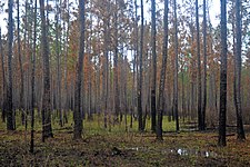 Longleaf pine (Pinus palustris) upland habitat after a recent fire. Big Thicket National Preserve, Hickory Creek Unit, Tyler Co. Texas; 23 Mar 2020
 -
 The same vicinity as previous image five months after the fire. Big Thicket National Preserve, Hickory Creek Savannah Unit, Tyler Co. Texas; 20 Aug 2020
 -
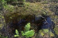 Sphagnum bogsor "acid bogs" with pH levels as low as 4.5 occur in the region. Big Thicket National Preserve, Turkey Creek Unit, Tyler Co. Texas; 1 May 2020
 -
 Baygall blackwater (left) mixing with typical muddy water (right). Big Thicket National Preserve, Jack Gore Baygall Unit, Hardin Co. Texas; 3 April 2020
 -
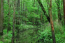 Lush vegetation in the Village Creek floodplain. Roy E. Larsen Sandyland Sanctuary, Hardin Co. Texas; 30 April 2010


Exact numbers of plant and animal species occurring in the Big Thicket region are difficult to state objectively due to a number of factors including: the imprecise boundaries of the area; which (if any) accidental and
Flora
The area contains over 100 species of trees and shrubs, with longleaf pine (
- Wildflower gallery
-
 Coral bean (Erythrina herbacea) Tyler County
 -
 False gromwell (Onosmodium bejariense) Walker County
 -
 Rose mallow (Hibiscus sp.) Hardin County
 -
 Pinewoods lily (Alophia drummondii) Hardin County
 -
 Turkcap (Malvaviscus arboreus var. drummondii) San Jacinto County
 -
 Ladies'-tresses orchid (Spiranthes sp.) Tyler County
 -
 Turnsole (Heliotropium indicum) Liberty County
_photographed_in_Tyler_County,_Texas,_USA_(12_May_2012).jpg)
_photographed_in_Walker_County,_Texas,_USA_(26_April_2014).jpg)
_photographed_in_Hardin_County,_Texas,_USA_(6_November_2019).jpg)
_photographed_in_Hardin_County,_Texas,_USA_(11_May_2012).jpg)
_photographed_in_San_Jacinto_County,_Texas,_USA_(16_August_2014).jpg)
_photographed_in_Tyler_County,_Texas,_USA_(11_May_2012).jpg)
_photographed_in_Liberty_County,_Texas,_USA_(21_October_2017).jpg)
-
 Southern arrowwood (Viburnum dentatum), Tyler County
 -
 Broad-leaf snoutbean (Rhynchosia latifolia), Polk County
 -
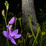 Grass-pink orchid (Calopogon sp.), Tyler County
 -
 Pitcher plant (Sarracenia alata), Tyler County
 -
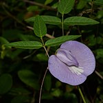 Butterfly pea (Centrosema virginianum), Polk County
 -
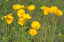 Lance-leaved coreopsis (Coreopsis lanceolata), Hardin County
 -
 Short-stem iris (Iris brevicaulis) Polk County
,_photographed_on_11_May_2012,_Tyler_County,_Texas,_USA,_by_William_L._Farr.jpg)
,_photographed_on_22_May_2020,_Polk_County,_Texas,_USA,_by_William_L._Farr.jpg)
),_photographed_on_1_May_2020,_Tyler_County,_Texas,_USA,_by_William_L._Farr.jpg)
,_photographed_on_1_May_2020,_Tyler_County,_Texas,_USA,_by_William_L._Farr.jpg)
,_photographed_on_22_May_2020,_Polk_County,_Texas,_USA,_by_William_L._Farr.jpg)
,_photographed_on_12_May_2020,_Hardin_County,_Texas,_USA,_by_William_L._Farr.jpg)
,_photographed_on_12_May_2020,_in_Polk_County,_Texas,_USA,_by_William_L._Farr.jpg)
Fauna
During the
Well over 500 species of vertebrates occur in the Big Thicket region, including more than 50 mammals, 300 birds, 60 reptiles, 30 amphibians, and over 90 fishes. The records and numbers below for mammals, reptiles, and amphibians are based on county records for Hardin, Jasper, Liberty, Montgomery, Polk, San Jacinto, Tyler, and Walker counties, which in a few cases may reflect marginal, peripheral, and
Mammals: About 54 species of mammals occur in the Big Thicket (not counting extirpated species), including such species as the Virginia opossum (
Although once common in the Big Thicket, the American black bears (
- Conroe: "A few still found in the big thicket 15 mile south of here."
- Beaumont: "A few still found in the forest northwest of here."
- Sour Lake: "Still common in the swamps near here; a few killed every year."
- Rockland: "Now very rare or quite extinct."
Vernon Bailey, chief naturalist for the
Conversely other species have been introduced to the area like the nutria (
- Mammal gallery
-
 Nine-banded armadillo (Dasypus novemcinctus)
 -
 American beaver (Castor canadensis)
 -
 Southern flying squirrel (Glaucomys volans)
 -
 Rafinesque's big-eared bats (Corynorhinus rafinesquii)
 -
 Eastern spotted skunk (Spilogale putorius)
 -
 River otter (Lontra canadensis)
 -
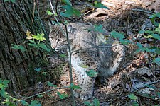 Bobcat (Lynx rufus)


.jpg)
.jpg)
.jpg)
Birds: Three hundred species of migratory and nesting birds occur in the Big Thicket including the red-cockaded woodpecker, a state and federal endangered species.[32] The extinct ivory-billed woodpecker once occurred in the Big Thicket.[33]
- Bird gallery
-
 Red-cockaded woodpecker
 -
 Bachman's sparrow (Peucaea aestivalis), Hal Scott Reserve, Florida
 -
 Scissor-tailed flycatcher (Tyrannus forficatus) in Walker County
 -
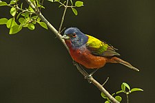 Painted bunting (Passerina ciris), Texas
 -
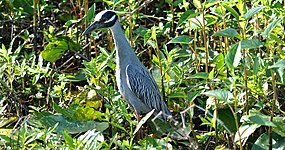 Yellow-crowned night-heron (Nyctanassa violacea) in Harris County
 -
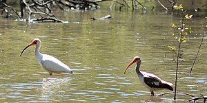 White ibis (Eudocimus albus) adult and immature plumage, Trinity River National Wildlife Refuge


_Walker_Co._TX._photo_W._L._Farr.jpg)
.jpg)
_Harris_Co._TX._photo_W._L._Farr.jpg)
_showing_adult_(left)_and_immature_(right)_plumage,_Trinity_River_National_Wildlife_Refuge,_Texas.jpg)
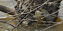
Reptiles: Sixty-one species of reptiles are known from the Big Thicket area including the alligator, 15 turtles, 12 lizards, and 33 snakes. Along with birds, reptiles are among the more commonly seen wildlife and they are an important part of the forest community or ecosystems. The American alligator (
Turtle diversity in the American Gulf Coast states is among the highest in the world. The red-eared slider (
Lizards commonly seen include green anoles (
- Reptile gallery
-
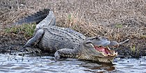 American alligator (Alligator mississippiensis) in Chambers County
 -
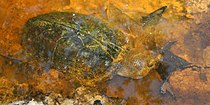 Razorback musk turtle (Sternotherus carinatus) in Hardin County
 -
 Sabine map turtle (Graptemys sabinensis) in Orange County
 -
 Three-toed box turtle (Terrapene carolina) in Walker County
 -
 Five-lined skink (Plestiodon fasciatus) in Liberty County
 -
 Prairie lizard (Sceloporus consobrinus) in Hardin County
 -
 Green anole (Anolis carolinensis) in Polk County
_Chambers_Co._Texas._photo_W._L._Farr.jpg)
_Hardin_Co._Texas._photo_W._L._Farr.jpg)
_Orange_Co._Texas._photo_W._L._Farr.jpg)
_Walker_Co._Texas._photo_W._L._Farr.jpg)
_Liberty_Co._Texas._photo_W._L._Farr.jpg)
_Hardin_Co._Texas._photo_W._L._Farr.jpg)
_Polk_Co._Texas._photo_W._L._Farr.jpg)
Snakes: With 33 species, the highest diversity among the reptiles are the snakes. Some of the more common species include the eastern hognose snake (
There are five species of venomous snakes in the area. Two rattlesnakes, the pygmy rattlesnake (
- Snake gallery
-
 Diamondback watersnake (Nerodia rhombifer) in San Jacinto County
 -
 Rough greensnake (Opheodrys aestivus) in Tyler County
 -
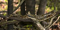 Texas rat snake (Pantherophis obsoletus) in Liberty County
 -
 Prairie kingsnake (Lampropeltis calligaster) in Tyler County
 -
 Texas coral snake (Micrurus tener) in Houston County
 -
 Copperhead (Agkistrodon contortrix) in Liberty County
 -
 Cottonmouth (Agkistrodon piscivorus) in Liberty County
_photographed_in_San_Jacinto_Co.,_Texas._W._L._Farr.jpg)
_photographed_in_Tyler_Co.,_Texas._W._L._Farr.jpg)
_photographed_in_Liberty_Co.,_Texas._W._L._Farr.jpg)
_photographed_in_Tyler_Co.,_Texas._W._L._Farr.jpg)
_photographed_in_Houston_Co.,_Texas._W._L._Farr.jpg)
_photographed_in_Liberty_Co.,_Texas._W._L._Farr.jpg)
_photographed_in_Liberty_Co.,_Texas._W._L._Farr.jpg)
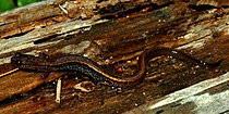
Amphibians: There are 31 species of amphibians found in the Big Thicket area, including 11 species of
Common toads and frogs include the Gulf Coast toad (
- Amphibian gallery
-
 Small-mouthed salamander (Ambystoma texanum) in Liberty County
 -
 Dwarf salamander (Eurycea quadridigitata) in Polk County
 -
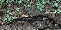
 Eastern newt (Notophthalmus viridescens) in Walker County
 -
 East Texas toad (Anaxyrus velatus or woodhousii × fowleri) in Hardin County
 -
 Eastern narrow-mouth toad, (Gastrophryne carolinensis) in Liberty County
 -
 Gray treefrog (Hyla versicolor) in Montgomery County
 -
 Green treefrog (Hyla cinerea) in Hardin County
_Liberty_Co._Texas._photo_by_W._L._Farr.jpg)
_Polk_Co._Texas._W._L._Farr.jpg)
_Walker_Co._Texas._photo_by_W._L._Farr.jpg)
_Hardin_Co._Texas._photo_by_W._L._Farr.jpg)
_Liberty_Co._Texas._photo_by_W._L._Farr.jpg)
_Montgomery_Co._Texas._photo_by_W._L._Farr.jpg)
_Hardin_Co._Texas._photo_by_W._L._Farr.jpg)
Fishes: Well over 90 species of fishes are known from the area. The Big Thicket National Preserve inventoried 92 species in the preserve's waters and another 20 species are noted as possible occurrences.[41] The National Park Service checklist includes 104 species.[42] Others source note 98 species[5] and 94 species.[43] In the smaller tributaries the most abundant species are minnows, killifishes, darters, bass, and bullhead catfish, while larger creeks and bayous are dominated by channel, blue, and flathead catfish, sunfishes, largemouth and spotted bass, and crappie.[41]
Insects: Studies have documented nearly 1,800 species of Lepidoptera (butterflies and moths) in the Big Thicket.[44]
Dragonflies and damselflies (
- Dragonflies and damselflies (Odonata) gallery
-
 Common green darner (Anax junius), male, Liberty County
 -
 Ebony jewelwing (Calopteryx maculata), male, San Jacinto County
 -
 Needham's skimmer (Libellula needhami) female, Harris Co County
 -
 Calico pennant (Celithemis elisa) male, Chambers County
 -
 Roseate skimmer (Orthemis ferruginea), male, Liberty County
 -
 Widow skimmer (Libellula luctuosa), female, Houston County
 -
 Sarracenia spiketail (Cordulegaster sarracenia) Rapides Parish, Louisiana
,_male,_Liberty_County.jpg)
,_male,_San_Jacinto_County.jpg)
_female,_Harris_Co_County.jpg)
_male,_Chambers_County.jpg)
,_male,_Liberty_County.jpg)
,_female,_Houston_County.jpg)
_Rapides_Parish,_LA,_USA_(7_April_2019)_2.jpg)
History
In pre-Columbian times, people of the

The Spaniards ruled the region c. 1521–1810, defining the Big Thicket's boundaries with the north as
After Mexican independence (c. 1810–1836), the region remained largely undeveloped. One of the earliest European naturalists to survey Texas was

The 1860 census showed there were about 200 sawmills statewide, but most were located near the Gulf Coast or north of the Big Thicket. Compared to other states, lumber production in Texas was small. As late as 1870, the majority of the forest of East Texas remained untouched. However that soon changed as the "bonanza era" (c. 1880–1930) of Texas lumbering began, facilitated by a rapidly developed railroad system. In 1877

William Goodrich Jones (1860–1950), "the father of Texas forestry" was a bank president and civic leader in Temple, Texas. He had some exposure to good forestry practices in Germany and understood the commercial benefits of well-managed forests and he was appalled with what he saw in East Texas. He was not a conservationist, he advocated for sustainable forestry methods as a good business practice, including reforestation, maintaining soils, grasses, wildlife, and establishing parks. In 1898 the United States Bureau of Forestry asked Jones to write a report on the status of forestry in Texas. Jones condemn the destructive and wastefulness of the logging industry and predicted the forest would be gone in 25 years without changes. He recommended state and federal regulations with sustainable harvest and reforestation programs. In 1914 Jones formed the Texas Forestry Association with public officials, lumbermen, and conservationists. In collaboration with the
What came to be a 50-year struggle to protect a portion of the Big Thicket for posterity begin in 1927 when R. E. Jackson, a railroad conductor, formed the East Texas Big Thicket Association (ETBTA) which sought to preserve 435,000 acres (1,760 km2). With Don Baird, of the Texas Academy of Science, the ETBTA instigated a biological survey that was conducted by Hal B. Parks and Victor L. Cory in 1936 defining the Big Thicket as a 3,350,000-acre (13,600 km2) area of East Texas.
Protected and public land
Don't plan to hike the Big Thicket. A hiker expects to cover distance. Plan to stroll the Thicket - or saunter, to use Thoreau's word, pausing often to let your eyes squint and your ears pick up rustling and callings.
— Howard Peacock[5]
The headquarters of Big Thicket National Preserve (BTNP) are located 8 miles (13 km) north of
- Huntsville State Park, Texas Parks and Wildlife (2,083 acres (8.43 km2))[72]
- Lake Houston Wilderness Park, Houston Parks and Recreation Department (4,786 acres (19.37 km2))[73]
- Martin Dies Jr. State Park, Texas Parks and Wildlife (705 acres (2.85 km2))[74]
- Roy E. Larsen Sandyland Sanctuary, The Nature Conservancy (5,654 acres (22.88 km2))[75]
- Sam Houston National Forest, U.S Department of Agriculture, Forest Service, Big Creek Scenic Area (1,420 acres (5.7 km2)), Little Lake Creek Wilderness (3,855 acres (15.60 km2))[76]
- Trinity River National Wildlife Refuge, U.S. Fish and Wildlife Service (30,000 acres (120 km2))[77]
- Village Creek State Park, Texas Parks and Wildlife (1,090 acres (4.4 km2))[78]
Ghost Road
A dirt road leading north out of the town of
Notable people
- John Alexander (born 1945, Beaumont, Jefferson County), American painter that often draws inspiration and paints the landscape of Southeast Texas
- Brian Philip Babin (born 1948, resident of Woodville, Tyler County) U.S. representative from Texas's 36th congressional district since January 2015
- Annette Gordon-Reed (born 1958, Livingston, Polk County) historian and Pulitzer Prize winning author
- George Glenn Jones(1931, Saratoga, Hardin County – 2013) country musician and songwriter
- Margo Jones (1913, Livingston, Polk County – 1955) stage and theater director nicknamed "The Texas Tornado"
- Aubrey Wilson Mullican (1909, Polk County – 1967) known as "Moon Mullican, King of the Hillbilly Piano Players", country-western musician and songwriter
Bibliography
- Abernethy, Frances Edward (2014) Let The River Run Wild! Saving The Neches. Stephen F. Austin University Press, Nacogdoches. ?? pp. ISBN 9781622880287
- Ajilvsgi, Geyata (1979) Wild Flowers of the Big Thicket: East Texas, and Western Louisiana. Texas A&M University Press. College Station, Texas 361 pp. ISBN 0-89096-064-X
- Bowman, Bob (1990). The 35 Best Ghost Towns in East Texas and 220 Other Towns We Left Behind. Best of East Texas Publishers, Lufkin ?? pp. ISBN 978-1878096128
- Brock, Ronald G. (2022) The Thicket's Prodigy.Galt/Mirrin Publishing, LLC, Scottsdale. 390 pp. ISBN 9798986514406
- Donovan, Richard M. (2006). Paddling the Wild Neches. Texas A&M University Press, College Station. 237 pp. ISBN 978-1585444960
- Douglas, William O. (1967) Farewell to Texas: a Vanishing Wilderness. McGraw-Hill, New York. 242 pp.
- Fritz, Edward C. (1993) Realms of Beauty: A Guide to the Wilderness Areas of East Texas, revised edition. University of Texas Press, Austin. 120 pp. ISBN 0-292-72479-9
- Gunter, Pete A. Y. (1971) The Big Thicket: A Challenge for Conservation. Jenkins 172 pp. ISBN 978-0856990441
- Gunter, Pete A. Y. (1993) The Big Thicket: An Ecological Reevaluation (Philosophy and Environment, Vol. 2). University of North Texas Press, Denton. 229 pp. ISBN 9780929398525
- Gunter, Pete A. Y. (2015) Finding the Big Thicket: A Cartographic Approach. CreateSpace Independent Publishing Platform. 74 pp. ISBN 978-1516827497
- Henley, Dempsie (1970) The Murder of Silence: The Big Thicket Story. Texian Press, Waco. 274 pp.
- Landrey, Wanda A. (1976) Outlaws in the Big Thicket. Eakin Press, Woodway. 142 pp. ISBN 978-1571684929
- Landrey, Wanda A. (1990) Boardin' in the Thicket. University of North Texas Press, Denton. 216 pp. ISBN 978-0929398075
- MacRoberts, M.H., MacRoberts, B.R. and Rudolph, D.C. (2010). "Vertebrate Richness and Biogeography in the Big Thicket of Texas." The American Midland Naturalist, 164(1), pp.37-43.
- Maxwell, Robert S. & Robert D. Baker (2000) Sawdust Empire: The Texas Lumber Industry, 1830–1940. Texas A&M University Press, College Station. 256 pp. ISBN 978-1585440597
- McLeod, Claude A. (1972) The Big Thicket of Eastern Texas. Sam Houston State University Press, Huntsville. 33 pp.
- National Park Service (2013) A Summary of Biological Inventory Data Collected at Big Thicket National Preserve: Vertebrate and Vascular Plant Inventories. CreateSpace Independent Publishing Platform. 76 pages ISBN 978-1492785460
- Parker, Lois Williams (1977) The Big Thicket of Texas: A Comprehensive Annotated Bibliography. Sable Publishing Corp., Arlington. 225 pp. ISBN 978-0914832041
- Peacock, Howard (1984) The Big Thicket of Texas: America's Ecological Wonder. Little, Brown and Co. Boston. 89 pp. ISBN 0316695831
- Peacock, Howard (1994) Nature Lover's Guide to the Big Thicket. Texas A&M. University Press. College Station, Texas. 169 pp. ISBN 0-89096-589-7
- Pittman, Blair & William A. Owens (1978) The Natural World of the Texas Big Thicket (Louise Lindsey Merrick Texas Environment Series #2). Texas A&M University Press, College Station. 100 pp. ISBN 978-0890960615
- Riggs, Rob (2001) In the Big Thicket on the Trail of the Wild Man: Exploring Nature's Mysterious Dimension. Paraview Press, Old Chelsea Station, New York. 188 pp. ISBN 1944529519
- Shafer, Harry J., Edward P. Baxter, Thomas B. Stearns, and James Phil Dering (1975) Archeological Assessment Big Thicket National Preserve. Texas A&M University Press, College Station.
- Sitton, Thad (2008) Backwoodsmen: Stockmen and Hunters along a Big Thicket River Valley. University of Oklahoma Press, Norman. 328 pp. ISBN 978-0806139647
- Sitton, Thad & James H. Conrad (1998). Nameless Towns: Texas Sawmill Communities 1880–1942. University of Texas Press, Austin. 271 pp. ISBN 978-0292777262
- Sitton, Thad & C. E. Hunt (2008) Big Thicket People: Larry Jene Fisher's Photographs of the Last Southern Frontier, revised ed. (Bridwell Texas History Series). University of Texas Press, Austin. 156 pp. ISBN 978-0292717824
- Todd, David & David Weisman, editors. (2010). The Texas Legacy Project: Stories of Courage and Conservation. Texas A&M University Press, College Station. 296 pp. ISBN 978-1603442008
- Truett, Joe C. & Daniel W. Lay (1994). Land of Bears and Honey: A Natural History of East Texas. University of Texas Press, Austin. 198 pp. ISBN 978-0292781344
- Wells, Renee Hart (2018) Big Thicket Region. Arcadia Publishing Library Editions. 130 pp. ISBN 978-1540235893
University of North Texas Press, Temple Big Thicket Series
The University of North Texas Press, Denton, co-published with The Big Thicket Association and the assistance of T.L.L. Temple Foundation, a series of books on the Big Thicket (Maxine Johnston, series editor). The series included both new works and reprints of outstanding books of continuing interest, with subjects ranging from folklore, to cultural history, to biology and botany.[79]
- Francis Edward Abernethy, editor (2002) Tales from the Big Thicket (Temple Big Thicket Series #1). University of North Texas Press. 256 pp. ISBN 157441142X
- Loughmiller, Campbell & Lynn Loughmiller, editors (2002) Big Thicket Legacy (Temple Big Thicket Series #2) University of North Texas Press, Denton, TX. 256 pp. ISBN 9781574411560
- Watson, Geraldine Ellis (2013) Reflections on the Neches: A Naturalist's Odyssey along the Big Thicket's Snow River (Temple Big Thicket Series #3). University of North Texas Press, Denton. 376 pp. ISBN 9781574415353
- Cozine, Jr., James J. (2004). Saving the Big Thicket From Exploration to Preservation, 1685–2003 (Temple Big Thicket Series #4).University of North Texas Press. Denton. 272 pp. 4. ISBN 9781574411751
- Watson, Geraldine Ellis (2006) Big Thicket Plant Ecology: An Introduction, Third Edition (Temple Big Thicket Series #5). University of North Texas Press. 152 pp. ISBN 978-1574412147
- Bonney, Lorraine G. (2011) The Big Thicket Guidebook: Exploring the Backroads and History of Southeast Texas (Temple Big Thicket Series #6). University of North Texas Press, Denton. 848 pp. ISBN 157441318X
See also
References
- ^ a b "Listing of acreage – December 31, 2014" (XLSX). Land Resource Division, National Park Service. Retrieved October 24, 2015. (National Park Service Acreage Reports)
- ^ "NPS Annual Recreation Visits Report". National Park Service. Retrieved May 14, 2012.
- ^ "Sam Houston State University Archives Collection - The Big Thicket". Texas Archive of the Moving Image. Retrieved December 2, 2019.
- S2CID 85602718.
- ^ ISBN 978-0-8909-6596-2.
- ^ ISBN 978-0-8909-6064-6. Archivedfrom the original on December 12, 2023. Retrieved November 11, 2021.
- ^ a b "Big Thicket National Preserve". National Park Service. October 25, 2021. Archived from the original on October 26, 2019. Retrieved October 23, 2019.
- ^ "Big Thicket, Plants". National Park Service. July 13, 2020. Archived from the original on December 22, 2019. Retrieved December 22, 2019.
- ^ a b c d Abernethy, Francis Edward (September 30, 2020) [1976]. "Big Thicket". Handbook of Texas. Texas State Historical Association. Archived from the original on November 11, 2021. Retrieved November 11, 2021.
- ISBN 1-57441-175-6. Archivedfrom the original on December 12, 2023. Retrieved May 30, 2016.
- ^ ISBN 978-1-5744-1214-7. Archivedfrom the original on December 12, 2023. Retrieved November 12, 2021.
- ^ a b c Parks, H. B.; Cory, V. L.; et al. (1936). Biological survey of the East Texas Big Thicket area: The fauna and flora of the Big Thicket area. Special Publication sponsored by the Texas Academy of Sciences. Privately Published.
- ^ a b c d McLeod, C. A. (1972). The Big Thicket Forest of Eastern Texas: A Brief Historical Botanical and Ecological Report. Huntsville, Texas: Sam Houston State University.
- ^ MacRoberts, Michael H.; MacRoberts, Barbara R. (March 2004). "The Big Thicket: Typical or Atypical?". East Texas Historical Journal. 42 (1): 42–51. Archived from the original on July 9, 2020. Retrieved December 22, 2019.
- ^ ISBN 0-292-72479-9
- ^ a b Geology of Texas, Bureau of Economic Geology, The University of Texas, Austin (Accessed 7 December 2019)
- ^ Cozine (2004) p. x.
- ^ Big Thicket National Preserve: The Climate of Big Thicket Archived December 8, 2019, at the Wayback Machine (accessed 7 December 2019)
- ^ US Climate Data: Climate, Kountze, Texas Archived December 8, 2019, at the Wayback Machine (accessed 7 December 2019)
- ^ a b c d United States Census Bureau Archived July 9, 2021, at the Wayback Machine (Accessed December 2019)
- ^ City-Data.com: Hardin County, Texas (Accessed 10 December 2019)
- ^ Piney Woods forests Archived July 3, 2020, at the Wayback Machine. Terrestrial Ecoregions. World Wildlife Fund. Retrieved 1 July 2020
- ^ Western Gulf coastal grasslands Archived January 3, 2018, at the Wayback Machine. Terrestrial Ecoregions. World Wildlife Fund. Retrieved 1 July 2020
- ^ East Central Texas forests Archived July 1, 2020, at the Wayback Machine. Terrestrial Ecoregions. World Wildlife Fund. Retrieved 1 July 2020
- ^ National Park Service, Big Thicket National Preserve, Plant Communities Archived November 3, 2019, at the Wayback Machine
- ^ a b c d e f g h i j k l m n o p P. A. Harcombe, P. A., J. S. Glitzenstein, R. G. Knox, S. L. Orzell, & E. L. Bridges. (1993). Vegetation of the Longleaf Pine Region of the West Gulf Coastal Plain. 83-104 pp. Archived December 21, 2019, at the Wayback Machine In Hermann, Sharon M. (ed.). Proceedings of the Tall Timbers Fire Ecology Conference J. No. 18, The Longleaf Pine Ecosystem: ecology, restoration and management.
- ^ a b c Bridges, E. L. and S. L. Orzell. 1989. Longleaf pine communities of the West Gulf Coastal Plain. Natural Areas Journal 9:246-263.
- ^ United States Department of Agriculture, Natural Resources Conservation Service, Ecological Site Description: Clayey Flat[permanent dead link]
- ^ Texas Parks and Wildlife: Bald Cypress (Taxodium distichum Archived December 21, 2019, at the Wayback Machine)
- ^ ISBN 0-292-70241-8
- ^ ISBN 978-160344-734-8
- ^ a b c d e f Texas Parks & Wildlife, Federal and State Listed Species in Texas Archived December 28, 2019, at the Wayback Machine, accessed 2 November 2019
- ^ Michael Graczyk (February 21, 2007). "Big Thicket searches seek giant woodpecker that might be extinct". USA Today. Archived from the original on July 26, 2023. Retrieved October 25, 2015.
- ^ ISBN 978-0-8018-9121-2
- ^ Axtell, Ralph W. (1994) Interpretive Atlas of Texas Lizards: No. 13. Cnemidophorus sexlineatus. Southern Illinois University at Edwardsville. 31 pp.
- ^ Axtell, Ralph W. (1996) Interpretive Atlas of Texas Lizards: No. 16. Phrynosoma cornutum. Southern Illinois University at Edwardsville. 52 pp.
- ^ Himes, John G., Laurence M. Hardy, D. Craig Rudolph, and Shirley J. Burgdorf (2006) Movement patterns and habitat selection by native and repatriated Louisiana pine snakes (Pituophis ruthveni): implications for conservation. Herpetological Natural History. 9 (2): 103–116.
- ^ ISBN 0-292-79130-5
- ISBN 1-56098-828-2
- ISBN 978-1-4214-0633-6
- ^ a b National Park Service: Big Thicket National Preserve, Fish Archived November 4, 2019, at the Wayback Machine
- ^ National Park Service: Big Thicket, Park species list Archived November 4, 2019, at the Wayback Machine (accessed 4 November 2019)
- ISBN 978-1-58544-570-7
- ^ Big Thicket National Preserve, Research in the Big Thicket Archived November 4, 2019, at the Wayback Machine
- ISBN 978-0-292-71449-6
- ISBN 978-0-292-71448-9
- ISBN 0-87049-248-9.
- ^ Texas Historical Commission, Caddo Mounds History Archived March 5, 2019, at the Wayback Machine
- ^ Atakapa-Ishak Nation, website
- ^ Couser, Dorothy (July 1, 1995) [1976]. "Atakapa Indians". Handbook of Texas. Texas State Historical Association. Archived from the original on August 18, 2021. Retrieved November 11, 2021.
- ^ La Farge, Oliver (1956) A Pictorial History of the American Indian. Crown Publishers, Inc., New York. 272 pp.
- ^ Alabama-Coushattas Tribe of Texas, website Archived October 28, 2019, at the Wayback Machine
- ISBN 0-292-76015-9
- ISBN 0-87611-044-8
- ^ Geiser, Samuel Wood. 1948. Naturalists of the Frontier. Southern Methodist University Press, Dallas. 296 pp.
- ^ Estep, Raymond (March 21, 2019) [1952]. "Zavala, Lorenzo de (1788–1836)". Handbook of Texas. Texas State Historical Association. Archived from the original on September 5, 2020. Retrieved November 14, 2019.
- ^ Reichstein, Andreas V. (January 1, 1995) [1952]. "Galveston Bay and Texas Land Company". Handbook of Texas. Texas State Historical Association. Archived from the original on January 28, 2021. Retrieved November 14, 2019.
- ^ Wooster, Robert (January 10, 2018) [1952]. "Honey Island, TX". Handbook of Texas. Texas State Historical Association. Archived from the original on July 26, 2021. Retrieved November 14, 2019.
- ^ Kleiner, Diana J. (May 24, 2021) [1952]. "Sour Lake, TX". Handbook of Texas. Texas State Historical Association. Archived from the original on November 11, 2021. Retrieved November 11, 2021.
- ^ ISBN 0-934213-48-8
- ^ Wooster, Robert (March 1, 1995) [1952]. "Lumberton, TX". Handbook of Texas. Texas State Historical Association. Archived from the original on November 11, 2021. Retrieved November 11, 2021.
- ^ Kleiner, Diana J. (November 17, 2020) [1952]. "Kirbyville, TX". Handbook of Texas. Texas State Historical Association. Archived from the original on November 11, 2021. Retrieved November 11, 2021.
- ^ Wooster, Robert (April 1, 1995) [1952]. "Silsbee, TX". Handbook of Texas. Texas State Historical Association. Archived from the original on November 11, 2021. Retrieved November 11, 2021.
- ^ Wooster, Robert (February 1, 1995) [1952]. "Kountze, TX". Handbook of Texas. Texas State Historical Association. Archived from the original on November 11, 2021. Retrieved November 11, 2021.
- ^ Wooster, Robert (December 1, 1994) [1952]. "Camden, TX (Polk County)". Handbook of Texas. Texas State Historical Association. Archived from the original on November 11, 2021. Retrieved November 11, 2021.
- ^ Bowman, Bob (April 19, 2016) [1952]. "Diboll, TX". Handbook of Texas. Texas State Historical Association. Archived from the original on November 11, 2021. Retrieved November 11, 2021.
- ^ Maxwell, Robert S. (February 15, 2012) [1976]. "Lumber Industry". Handbook of Texas. Texas State Historical Association. Archived from the original on September 29, 2020. Retrieved November 18, 2019.
- ^ Wooster, Robert; Sanders, Christine Moor (April 2, 2019) [1976]. "Spindletop Oilfield". Handbook of Texas. Texas State Historical Association. Archived from the original on September 17, 2020. Retrieved November 18, 2019.
- ^ Maxwell, Robert S. (February 1, 1995). "Jones, William Goodrich (1860–1950)". Handbook of Texas. Texas State Historical Association. Archived from the original on November 11, 2021. Retrieved November 11, 2021.
- ^ Cozine, James (October 1993). "Defining the Big Thicket". East Texas Historical Journal. 31 (2): 57–71. Archived from the original on November 19, 2016. Retrieved October 24, 2015.
- ^ "Big Thicket National Preserve Texas" (PDF). National Park Service U.S. Department of Interior. Archived (PDF) from the original on November 22, 2015. Retrieved October 24, 2015.
- ^ Texas Parks and Wildlife, Huntsville State Park Archived November 8, 2019, at the Wayback Machine
- ^ Houston Parks and Recreation Department, Lake Houston Wilderness Park Archived September 16, 2020, at the Wayback Machine
- ^ Texas Parks and Wildlife, Martin Dies Jr. State Park Archived October 30, 2019, at the Wayback Machine
- ^ The Nature Conservancy, Roy E. Larsen Sandyland Sanctuary Archived October 30, 2019, at the Wayback Machine
- ^ U.S Department of Agriculture, Forest Service, Sam Houston National Forest Archived June 9, 2016, at the Wayback Machine
- ^ U.S. Fish and Wildlife Service, Trinity National Wildlife Refuge Archived November 5, 2019, at the Wayback Machine
- ^ Texas Parks and Wildlife, Village Creek State Park Archived October 30, 2019, at the Wayback Machine
- ^ University of North Texas Press, Temple Big Thicket Series Archived October 30, 2019, at the Wayback Machine
External links
- Big Thicket Association
- Big Thicket National Preserve
- Big Thicket in the Handbook of Texas
- Bragg Road - The Ghost Road of Hardin County Archived 2005-01-24 at the Wayback Machine
- Cozine, James. 1993. Defining the Bick Thicket: Prelude to Preservation. East Texas Historical Journal 31(2): 57-71.
- Cozine, James. 2004. Saving the Big Thicket: from exploration to preservation, 1685–2003. University of North Texas. Denton, Texas. 289 pp. ISBN 1-57441-175-6
- Fun365Days.com – regional tourism web site
- UNSCEO Biosphere Reserve: Big Thicket
- The Big Thicket: A Vanishing Wilderness (1970) (educational film) on the Texas Archive of the Moving Image