
Caguas, Puerto Rico
Caguas | ||
|---|---|---|
Central Santa Catalina; Caguas Cathedral; Old City Hall; and view of the Valley and the Cordillera Central | ||
|
Commonwealth | ||
| Founded | January 1, 1775 | |
| Barrios | ||
| Government | ||
| • ZIP Codes | 00725, 00726, 00727 | |
| Area code | 787/939 | |
| Major routes | ||
| Website | caguas.gov.pr | |
Caguas (Spanish pronunciation: [ˈkaɣwas], locally [ˈkawaʔ]) is a city and municipality of Puerto Rico located in the Central Mountain Range of Puerto Rico, south of San Juan and Trujillo Alto, west of Gurabo and San Lorenzo, and east of Aguas Buenas, Cidra, and Cayey. Caguas was founded in 1775. The municipality had a population of 127,244 at the 2020 census.[2]
Caguas is located 20 miles (32 km) from
Since 2009 Caguas is the only municipality in Puerto Rico recognized as a
History
The area of the
Puerto Rico was ceded by
The city grew considerably in size during the 1970s
Although not typically seen as part of the colloquial Área Metro of San Juan (
On August 7, 2002, Caguas was the site of the 2002 USAF Hercules air disaster, where all 10 military personnel on board lost their lives after an airplane carrying them struck a mountain in the south of the municipality.[12]
Hurricane Maria on September 20, 2017, triggered numerous landslides in Caguas with its wind and rain. Rivers were breached causing flooding of low-lying areas, and infrastructure and homes were destroyed. The hurricane caused $90 million in damages in Caguas.[13][14][15] More specifically, 40 homes were left without a roof and 30 were flooded in the Morales neighborhood. Escuela Segunda Unidad Diego Vázquez and the Centro Multiusos flooded as well.[16]
Geography
The city and municipality of Caguas are located approximately 30 minutes from the coastline both on the east (
Valle de Caguas

The city is located in one of the largest valleys in Puerto Rico, the Valle de Caguas or
This valley is fed mainly by the Grande de Loíza River, one of Puerto Rico's major rivers that feed into the Atlantic Ocean, and numerous tributaries such as the Cagüitas, along which the contemporary settlement of Caguas was built. The city's nickname Valle del Turabo comes from the Turabo River, which is another tributary that flows from the south. The Gurabo River, another major tributary, feeds into the Grande de Loíza at a region where the valley narrows into a rift valley that runs from west to east and ends in Humacao in the southeastern coast of the island.
As with other parts of Puerto Rico, the region of Caguas is susceptible to earthquakes. The municipality is located along the Great Northern Puerto Rico fault zone (GNPRfz) and in recent times the region experienced moderate size earthquakes in 1990[19] and 2010.[20]
Water features
- The Río Grande de Loíza divides the municipality from Gurabo.
- Other rivers: Río Bairoa and Río Cañas.
Climate

The climate is classified as a tropical monsoon climate, meaning the daily mean temperature from month to month is never less than 64.4 °F (18.0 °C), and there is a distinct wet and dry season. Rainfall is common in relative abundance throughout most of the year, although there is less rain than in the eastern coastal valleys. The land, however, is fertile and deep.
| Month | Jan | Feb | Mar | Apr | May | Jun | Jul | Aug | Sep | Oct | Nov | Dec | Year |
|---|---|---|---|---|---|---|---|---|---|---|---|---|---|
| Record high °F (°C) | 92 (33) |
93 (34) |
95 (35) |
95 (35) |
97 (36) |
99 (37) |
99 (37) |
98 (37) |
101 (38) |
99 (37) |
95 (35) |
95 (35) |
101 (38) |
| Mean daily maximum °F (°C) | 79.3 (26.3) |
80.9 (27.2) |
86.4 (30.2) |
88.1 (31.2) |
89.4 (31.9) |
90.5 (32.5) |
90.7 (32.6) |
91.1 (32.8) |
91.0 (32.8) |
90.0 (32.2) |
87.4 (30.8) |
84.9 (29.4) |
87.5 (30.8) |
| Daily mean °F (°C) | 70.9 (21.6) |
71.1 (21.7) |
74.3 (23.5) |
77.1 (25.1) |
79.6 (26.4) |
81.4 (27.4) |
82.7 (28.2) |
82.5 (28.1) |
82.8 (28.2) |
81.6 (27.6) |
78.1 (25.6) |
75.4 (24.1) |
78.1 (25.6) |
| Mean daily minimum °F (°C) | 62.5 (16.9) |
61.1 (16.2) |
62.3 (16.8) |
66.0 (18.9) |
69.8 (21.0) |
72.4 (22.4) |
74.7 (23.7) |
74.0 (23.3) |
74.7 (23.7) |
73.2 (22.9) |
68.7 (20.4) |
65.8 (18.8) |
68.8 (20.4) |
| Record low °F (°C) | 50 (10) |
50 (10) |
49 (9) |
56 (13) |
62 (17) |
65 (18) |
66 (19) |
67 (19) |
66 (19) |
64 (18) |
59 (15) |
57 (14) |
49 (9) |
| Average rainfall inches (mm) | 3.05 (77) |
2.68 (68) |
1.39 (35) |
4.32 (110) |
10.46 (266) |
4.22 (107) |
4.20 (107) |
5.03 (128) |
9.74 (247) |
7.12 (181) |
7.87 (200) |
3.46 (88) |
59.52 (1,512) |
| Average rainy days (≥ 0.10) | 9 | 7 | 6 | 12 | 18 | 11 | 8 | 10 | 14 | 10 | 18 | 9 | 100 |
| Source: Southeast Regional Climate Center [21] | |||||||||||||
Barrios

Like all municipalities of Puerto Rico, Caguas is subdivided into barrios:[22][23][24]
Sectors
Barrios (which are, in contemporary times, roughly comparable to
Special Communities
Comunidades Especiales de Puerto Rico (Special Communities of Puerto Rico) are marginalized communities whose citizens are experiencing a certain amount of social exclusion. A map shows these communities occur in nearly every municipality of the commonwealth. Of the 742 places that were on the list in 2014, the following barrios, communities, sectors, or neighborhoods were in Caguas: Bairoa La 25, Morales neighborhood, Parcelas Viejas in Borinquén, Sector La Barra, and Comunidad La Quebrada in Río Cañas, Hoyo Frío in Las Carolinas, Lajitas, Las Carolinas, Los Muchos, Los Panes in Beatriz, and Savarona.[32][33]
Tourism
Landmarks and places of interest

There are seven places in Caguas listed on the US National Register of Historic Places:[34]
- Caguas City Hall (Alcaldia de Caguas, the city hall building)
- Primera Iglesia Bautista de Caguas
- Gautier Benítez High School
- Escuela Vocacional Aguayo Aldea
- Logia Union y Amparo #44
- Puente No. 6 or (Spanish: Puente La Concepción)
- Carretera Central
Other landscapes, landmarks and tourist attractions in Caguas include:
- Caguas Museum of Art
- Caguas Museum of Folk Arts
- Caguas Museum of History
- Caguas Tobacco Museum
- Dulce Nombre de Jesús Cathedral (Catedral de Caguas), the old city hall and other historical buildings at Plaza Palmer, the main town square.
- Hacienda Catalina Ruins, located in the area of Las Catalinas Mall
- Hacienda Country Club
- La Casa del Ajedrez (The House of Chess)
Parks and natural areas

The municipality of Caguas is home to various parks and natural protected areas managed by different governmental entities ranging from the municipal government, the Puerto Rico Department of Natural and Environmental Resources, the Puerto Rico Conservation Trust, and the United States Fish & Wildlife Service.[35]
- Aguas Buenas Cave and Caverns System Nature Reserve, an extensive cave system partially located in the municipality of Caguas.
- Bairoa River Natural Protected Area, protected riparian forest along the Bairoa River.
- Borinquen Valley Natural Area, 25 acres of protected forest located in barrio Borinquen.
- Caguas Real Nature Reserve, 60 acres of riparian forest along the Turabo River managed by the United States Fish & Wildlife Service.
- Caguas Regional Forest, a protected secondary forest and riparian ecosystem along the Turabo River.
- Carite State Forest and Reserve, one of the 20 units in the state forest system of Puerto Rico, partially located in Caguas.
- Cerro Borrás, formerly home to various recreational parks such as Moisty Park, currently preserved as a secondary forest.
- Chalets de Bairoa Natural Area, currently being developed as a preserved ecological corridor within the Valley of Caguas.
- Charco El Cantil, natural swimming pool located along the Turabo River.
- Finca Longo and Altos de San Luis, partially managed by the DRNA forest service and the municipality of Caguas.
- Jardín Botánico y Cultural William Miranda Marín (Botanical and Cultural Gardens), botanical garden and cultural institution containing the ruins of the Hacienda San José plantation and Taíno archaeological sites, located in barrio Cañabón.
- Jorge Sotomayor del Toro Protected Natural Area, a protected natural arealocated adjacent to the Carite Forest.
Voy Turistiendo Campaign
To stimulate local tourism during the COVID-19 pandemic in Puerto Rico, the Puerto Rico Tourism Company launched the Voy Turistiendo (I'm Touring) campaign in 2021. The campaign featured a passport book with a page for each municipality. The Voy Turisteando Caguas passport page lists the Jardín Botánico William Miranda Marin, the Catedral Dulce Nombre de Jesús, the Plaza de Recreo Santiago R. Palmer and the Museo de Artes Populares as places of interest for locals.[36]
Culture
Festivals and events
Caguas celebrates its patron saint festival in July. The Fiestas Patronales de Nuestra Sra. del Carmen is a religious and cultural celebration that generally features parades, games, artisans, amusement rides, regional food, and live entertainment.[18]
Other festivals and events include:
- Rosario Cantado a los Reyes – 4 January
- Three Kings Festival – 5 January
- Criolla Beatriz – February
- Criolla Borinquen Fair – March
- Criolla Cañabón Fair – April
- Felipe "La Voz" Rodríguez' Birthday – 8 May
- Al Fresco – Every last Friday of each month
- Cross Festival – 23–31 May
- Typical Criole Festival – 1–2 June
- Latin American Musical
Sports
The
The
Caguas is home to the
and others.The Criollas de Caguas women's volleyball team has won 9 national Puerto Rico titles and has made it to the finals more than 15 times. The team is a member of the Liga de Voleibol Superior Femenino (LVSF).
The Criollos de Caguas FC soccer team is considered one of the most successful clubs in the island winning multiple tournaments and cups in Puerto Rican soccer including the National League Title in 2015.
Economy
In September 2005, city mayor William Miranda Marín levied the first municipal tax in Puerto Rico via city ordinance. Area merchants now charge a one cent tax for every dollar spent at all retail businesses. The tax has become known around the island as the "Willie Tax." It resulted in an estimated $500,000 monthly income for the city. However, the municipal tax was increased to 1.5% after the establishment of the 5.5% state tax, for a total of 7%, and the tax was declared illegal by the Puerto Rico's Supreme Court.[citation needed]
In 2006, Miranda Marín began calling Caguas "El Nuevo País de Caguas" ("The New Country of Caguas").
Agriculture
During the early part of the 20th century, Caguas hosted one of Puerto Rico's most important sugar manufacturers, which gave employment to thousands of Cagüeños.
Business
Numerous businesses and important buildings have opened in Caguas since the 1970s, including the imposing 23 story apartment building Caguas Tower, its adjacent competitors Bonneville Apartments, and the 10 floor Menonita Hospital.[37] There are also several shopping centers:
- Plaza del Carmen Mall
- Plaza Centro Mall
- Las Catalinas Mall
- Los Prados Mall
- Bairoa Shopping Center
- Villa Blanca Mall
- Angora Shopping Center
- Plaza Degetau
- Plaza Caguitas
- Del Rio Shopping Center
- Metro Plaza (Caguas, Puerto Rico)
Demographics
| Census | Pop. | Note | %± |
|---|---|---|---|
| 1900 | 19,857 | — | |
| 1910 | 27,160 | 36.8% | |
| 1920 | 35,920 | 32.3% | |
| 1930 | 47,728 | 32.9% | |
| 1940 | 53,356 | 11.8% | |
| 1950 | 60,132 | 12.7% | |
| 1960 | 65,098 | 8.3% | |
| 1970 | 95,661 | 46.9% | |
| 1980 | 117,959 | 23.3% | |
| 1990 | 133,447 | 13.1% | |
| 2000 | 140,502 | 5.3% | |
| 2010 | 142,893 | 1.7% | |
| 2020 | 127,244 | −11.0% | |
| U.S. Decennial Census[38] 1899 (shown as 1900)[39] 1910-1930[40] 1930-1950[41] 1960-2000[42] 2010[23] 2020[43] | |||
In 1899, the United States conducted its first census of Puerto Rico finding that the population of Caguas was 19,857.
In 2020, Caguas had a population of 127,244 compared to 142,893 in 2010. This shows an 11% decrease in the population in the municipality. The population density in 2020 was 2,200 people per square mile (850 people/km2). Hispanic or Latino of any race constitute 98.4% of the population of the municipality. There are also communities of Dominicans, Cubans and Colombians.
Government
All municipalities in Puerto Rico are administered by a mayor, elected every four years. The mayor of the city of Caguas were
1953 to 1969 - Angel Rivera
1969 to 1973 - Miguel Hernandez Rodriguez (New Progressive Party (PNP))
1973 to 1977 -
1977 to 1981 - Miguel Hernandez Rodriguez (PNP)
1981 to 1997 - Angel O. Berrios Diaz (PPD)
1997 to 2010 - William Miranda Marín (PPD)
2010 to present - William Miranda Torres (PPD)
The city belongs to the Senatorial district VII (Humacao), which is represented by two Senators. In 2016, Miguel Laureano (PNP) and José Luis Dalmau (PPD) were elected as District Senators.
Symbols
The municipio or municipality has an official flag and coat of arms.[45]
Flag and coat of arms
The colors blue and gold were chosen for the shield, distinctive of the city of Caguas. The figures symbolize both the indigenous and Christian origins of the city.
The coat of arms consists of a shield with a blue field. Upon the field are two sets of three golden arrows, forming a
On the flag, the shield sits atop another blue field on which the cross of arrows motif is repeated.[46]
Transportation


Public transportation in Caguas, as in most of Puerto Rico, is limited to small "guaguas públicas" (Mini Bus). There is inexpensive but slow service to and from San Juan and Rio Piedras. Several buses and public taxi services serve the town to a limited degree. In 2019,[11] 91.55% of the population relied on their own cars or carpool services to commute.
A "light interurban rail" system connecting Caguas to San Juan was in the planning stages and discarded due to lack of funding.
Caguas is served by one freeway, one tolled expressway and one main divided highway.
There are 86 bridges in Caguas.[47]
Education
High schools
- Colegio Católico Notre Dame
- Elohim Christian Academy
- New Generation Christian Academy (formerly CLA)
- Caguas Military Academy
- Colegio Bautista
- Colegio Católico San Juan Apóstol
- Academia Cristo de los Milagros
- Dr. Juan José Osuna High school
- José Gautier Benítez High school
- Escuela Libre de Música - Antonio S. Paoli
- Manuela Toro Morice High School
- Republic of Costa Rica Vocacional High School of Caguas
- Eloisa Pascual "Bairoa III" High School
- Rio Cañas High School
- Santa Rosa Superior School
- Thomas Alva Edison School
- Colegio San José Superior
- Escuela Secundaria Especializada en Ciencias, Matemáticas y Tecnología (CIMATEC)
- Caguas Private School (CPS)
Academia Adventista Caguas
Higher education
- San Juan Bautista School of Medicine
- Huertas Junior College
- Instituto EDIC
- Columbia College
- Turabo University at Gurabo (Gurabo, Puerto Rico)
Health care
- Hospital Hima San Pablo
- Menonita Caguas Regional Hospital
- San Juan Bautista Medical Center
- Corporacion SANOS
Sister cities
Caguas, Puerto Rico is
Gallery
-
 Museo de Arte de Caguas
 -
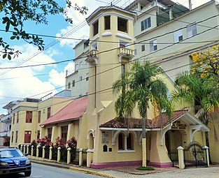 The José Ignacio Quintón Center for Criollo Music, located at the corner of Calle Ruiz Belvis and Calle Intendente Ramírez in Caguas, Puerto Rico. The center occupies the historic First Baptist Church of Caguas (built 1907–1909), and is listed on the U.S. National Register of Historic Places.
 -
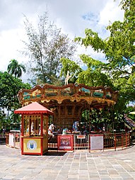 Carousel in Plaza de Caguas
 -
 Caguas cathedral 'Dulce Nombre de Jesús' founded in 1729. On the facade hangs an image of native son BlessedCarlos Manuel Rodríguez, whose body rests in the cathedral.
 -
 Entrance to the Botanical and Cultural Gardens in Caguas
 -
 Main square for recreation, Plaza de Recreo Santiago R. Palmer in Caguas barrio-pueblo
 -
 The Walmart in Caguas, Puerto Rico is one of five Walmart facilities on the island equipped with solar panels.


See also
References
- ^ "Demographics/Ethnic U.S. 2000 census" (PDF). Topeurtorico.org. Archived (PDF) from the original on February 16, 2008. Retrieved November 30, 2017.
- ^ "Puerto Rico Population Declined 11.8% From 2010 to 2020". Census.gov. Retrieved April 11, 2022.
- ^ Florencio Morales Ramos: Ramito, “el Cantor de la Montaña”. Archived 2017-11-07 at the Wayback Machine David Morales. Our Country Music. Undated. Accessed 8 December 2018.
- ^ Grupo Editorial EPRL (June 4, 2015). Fundación Puertoriqueña de las Humanidades (ed.). "Caguas". Enciclopedia de Puerto Rico (in Spanish). Archived from the original on June 29, 2015. Retrieved June 28, 2015.
- ^ "Caguas celebrates its Tree City recognition for the 10th consecutive time". US Forest Service. May 3, 2019. Retrieved February 14, 2024.
- ^ Katia Gil, de Lamadrid Pesant (2012). Caguas: Transformaciones territoriales desde el período colonial hasta 1952 (in Spanish). Gurabo, Puerto Rico: Universidad del Turabo. pp. 24–26.
- ^ "Memoria Viva: la Carretera Central de Puerto Rico". www.noticel.com. Retrieved October 21, 2021.
- ^ Joseph Prentiss Sanger; Henry Gannett; Walter Francis Willcox (1900). Informe sobre el censo de Puerto Rico, 1899, United States. War Dept. Porto Rico Census Office (in Spanish). Imprenta del gobierno. p. 161. Archived from the original on November 15, 2012. Retrieved June 7, 2020.
- ^ "American FactFinder - Results". archive.ph. February 13, 2020. Archived from the original on February 13, 2020. Retrieved September 6, 2021.
- ^ Samame, Juan Carlos. "Historia". Municipio de Caguas. Retrieved October 11, 2021.
- ^ a b "Caguas, PR | Data USA". datausa.io. Retrieved September 6, 2021.
- ^ Ranter, Harro. "ASN Aircraft accident Lockheed MC-130H Hercules 90-0161 Caguas". Aviation-safety.net. Archived from the original on October 24, 2012. Retrieved September 15, 2016.
- ^ "Preliminary Locations of Landslide Impacts from Hurricane Maria, Puerto Rico". USGS Landslide Hazards Program. USGS. Archived from the original on March 3, 2019. Retrieved March 3, 2019.
- ^ "Preliminary Locations of Landslide Impacts from Hurricane Maria, Puerto Rico" (PDF). USGS Landslide Hazards Program. USGS. Archived (PDF) from the original on March 3, 2019. Retrieved March 3, 2019.
- ^ "María, un nombre que no vamos a olvidar. María dejó en Caguas daños por más de $90 millones" [María, a name we'll never forget. $90 million in damages in Caguas left by María]. El Nuevo Día (in Spanish). June 13, 2019. Retrieved May 15, 2021.
- ^ "Minuto a minuto: AEE restablece parcialmente la energía en el aeropuerto". El Nuevo Día (in Spanish). September 29, 2017. Retrieved October 13, 2022.
- ^ "Orgullo y alegría en el Valle del Turabo". Elnuevodia.com. January 19, 2017. Archived from the original on December 28, 2018. Retrieved November 30, 2017.
- ^ a b "Caguas Municipality". Fundación Puertorriqueña de las Humanidades (FPH). Archived from the original on June 4, 2019. Retrieved March 20, 2019.
- ^ "M 4.7 - 1 km W of Juncos, Puerto Rico". earthquake.usgs.gov. Archived from the original on September 6, 2021. Retrieved September 6, 2021.
- ^ "M 5.1 - 3 km W of Aguas Buenas, Puerto Rico". earthquake.usgs.gov. Retrieved September 6, 2021.
- ^ "CAGUAS, PUERTO RICO". The University of North Carolina (Chapel Hill campus). Archived from the original on August 8, 2013. Retrieved October 26, 2011.
- ISBN 978-1-4766-0447-3. Retrieved December 25, 2018.
- ^ a b Puerto Rico:2010:population and housing unit counts.pdf (PDF). U.S. Dept. of Commerce Economics and Statistics Administration U.S. Census Bureau. 2010. Archived (PDF) from the original on February 20, 2017. Retrieved December 28, 2018.
- ^ "Map of Caguas at the Wayback Machine" (PDF). Archived from the original (PDF) on March 24, 2018. Retrieved December 29, 2018.
- ^ a b "US Census Barrio-Pueblo definition". factfinder.com. US Census. Archived from the original on May 13, 2017. Retrieved January 5, 2019.
- ^ "P.L. 94-171 VTD/SLD Reference Map 000 (2010 Census): Caguas Municipio, PR" (PDF). www2.census.gov. U.S. DEPARTMENT OF COMMERCE Economics and Statistics Administration U.S. Census Bureau. Archived (PDF) from the original on August 23, 2020. Retrieved August 22, 2020.
- ^ "P.L. 94-171 VTD/SLD Reference Map 001 (2010 Census): Caguas Municipio, PR" (PDF). www2.census.gov. U.S. DEPARTMENT OF COMMERCE Economics and Statistics Administration U.S. Census Bureau. Archived (PDF) from the original on August 23, 2020. Retrieved August 22, 2020.
- ^ "P.L. 94-171 VTD/SLD Reference Map 002 (2010 Census): Caguas Municipio, PR" (PDF). www2.census.gov. U.S. DEPARTMENT OF COMMERCE Economics and Statistics Administration U.S. Census Bureau. Archived (PDF) from the original on August 23, 2020. Retrieved August 22, 2020.
- ^ "Agencia: Oficina del Coordinador General para el Financiamiento Socioeconómico y la Autogestión (Proposed 2016 Budget)". Puerto Rico Budgets (in Spanish). Archived from the original on June 28, 2019. Retrieved June 28, 2019.
- ISBN 978-0-9820806-1-0
- ^ "Leyes del 2001". Lex Juris Puerto Rico (in Spanish). Archived from the original on September 14, 2018. Retrieved June 24, 2020.
- ISBN 978-0-9820806-1-0
- ^ "Comunidades Especiales de Puerto Rico" (in Spanish). August 8, 2011. Archived from the original on June 24, 2019. Retrieved June 24, 2019.
- ^ "Puerto Rico: Registro Nacional de Lugares Históricos" (PDF). geoisla.com. Government of Puerto Rico. Retrieved May 15, 2021.
- ^ Municipio Autónomo de Caguas (2015). "REVISIÓN INTEGRAL DEL PLAN TERRITORIAL DEL MUNICIPIO AUTÓNOMO DE CAGUAS" (PDF).
- ^ Pasaporte: Voy Turisteando (in Spanish). Compañia de Turismo de Puerto Rico. 2021.
- ^ Parés Arroyo, Marga (October 14, 2017). "Hospitales de la montaña viven una odisea tras la tempestad [Hospitals in the mountain are living an odyssey after the hurricane]". El Nuevo Día (in Spanish). Retrieved May 15, 2021.
- ^ "U.S. Decennial Census". United States Census Bureau. Archived from the original on February 13, 2020. Retrieved September 21, 2017.
- ^ "Report of the Census of Porto Rico 1899". War Department Office Director Census of Porto Rico. Archived from the original on July 16, 2017. Retrieved September 21, 2017.
- ^ "Table 3-Population of Municipalities: 1930 1920 and 1910" (PDF). United States Census Bureau. Archived (PDF) from the original on August 17, 2017. Retrieved September 21, 2017.
- ^ "Table 4-Area and Population of Municipalities Urban and Rural: 1930 to 1950" (PDF). United States Census Bureau. Archived (PDF) from the original on August 30, 2015. Retrieved September 21, 2014.
- ^ "Table 2 Population and Housing Units: 1960 to 2000" (PDF). United States Census Bureau. Archived (PDF) from the original on July 24, 2017. Retrieved September 21, 2017.
- ^ "PUERTO RICO: 2020 Census". The United States Census Bureau. Retrieved August 25, 2021.
- ^ "Population and Housing Unit Estimates". United States Census Bureau. Archived from the original on December 27, 1996. Retrieved September 21, 2017.
- ^ "Ley Núm. 70 de 2006 -Ley para disponer la oficialidad de la bandera y el escudo de los setenta y ocho (78) municipios". LexJuris de Puerto Rico (in Spanish). Retrieved June 15, 2021.
- ^ "CAGUAS". LexJuris (Leyes y Jurisprudencia) de Puerto Rico (in Spanish). February 19, 2020. Archived from the original on February 19, 2020. Retrieved September 16, 2020.
- ^ "Caguas Bridges". National Bridge Inventory Data. US Dept. of Transportation. Archived from the original on February 20, 2019. Retrieved February 19, 2019.
Further reading
- Caguas and its barrios, United States Census Bureau
- Carrasquillo, Rosa E. (2006). Our Landless Patria: Marginal Citizenship and Race in Caguas, Puerto Rico, 1880–1910. Lincoln, Nebraska: University of Nebraska Press. OCLC 61204347.
External links
- Eastern Center Virtual Library (in Spanish)
- Caguas Community Portal (in Spanish)
- Huertas Junior College (in Spanish)
- San Juan Bautista School of Medicine
- Columbia College (in Spanish)
- Grand Valley State University(in Spanish)
- Jardín Botánico y Cultural William Miranda Marín (in Spanish)
- Caguas, Puerto Rico on Facebook
Places adjacent to Caguas, Puerto Rico | ||||||||||||||||
|---|---|---|---|---|---|---|---|---|---|---|---|---|---|---|---|---|
| ||||||||||||||||
| International | |
|---|---|
| National | |
| Geographic | |