
Châteaubriant
Châteaubriant
| |
|---|---|
Subprefecture and commune | |
.jpg) Porte Neuve ("New Gate") in the old town | |
.svg) Coat of arms | |
Location of Châteaubriant  | |
 Châteaubriant  Châteaubriant | |
| Coordinates: 47°43′04″N 1°22′30″W / 47.7178°N 1.375°W | |
| Country | France |
| Region | Pays de la Loire |
| Department | Loire-Atlantique |
| Arrondissement | Châteaubriant-Ancenis |
| Canton | Châteaubriant |
| Intercommunality | CC Châteaubriant-Derval |
| Government | |
| • Mayor (2020–2026) | Alain Hunault[1] |
| Area 1 | 33.62 km2 (12.98 sq mi) |
| • Metro | 635.9 km2 (245.5 sq mi) |
| Population (2021)[2] | 12,189 |
| • Density | 360/km2 (940/sq mi) |
| • Metro (2018[3]) | 33,961 |
| • Metro density | 53/km2 (140/sq mi) |
| Time zone | UTC+01:00 (CET) |
| • Summer (DST) | UTC+02:00 (CEST) |
| INSEE/Postal code | 44036 /44110 |
| Elevation | 48–107 m (157–351 ft) |
| 1 French Land Register data, which excludes lakes, ponds, glaciers > 1 km2 (0.386 sq mi or 247 acres) and river estuaries. | |
Châteaubriant (French: [ʃɑtobʁijɑ̃] ⓘ; Breton: Kastell-Briant; Gallo: Châtiaoberiant) is a town in western France, about 350 km (220 mi) southwest of Paris, and one of the three sous-préfectures of the Loire-Atlantique department. Châteaubriant is also situated in the historical and cultural region of Brittany, and it is the capital of the Pays de la Mée.
A part of the traditional province of Brittany, Châteaubriant also lies on the threshold of Anjou, and it was an important stronghold in northwestern France during the Middle Ages. The town appeared during the 11th century, around a castle and a priory. A fair, which still exists, was also founded in 1050. Châteaubriant played a certain role during the Mad War between France and Brittany and became a significant cultural centre in the 16th century, when the Renaissance château was built in the medieval fortress.
The town is situated between Nantes and Rennes, and tends to be economically oriented towards the latter. The medieval fair and cattle market are still important for the local economy, but Châteaubriant also developed a metallurgical industry during the 19th century, and then plastics manufacturing during the 20th century.
Châteaubriant is noteworthy for the
Geography
Location

Châteaubriant lies at the north of the Loire-Atlantique département, in the middle of a triangle between Nantes, Angers and Rennes. The town is not situated on any of the roads that link the three cities, thus, it is somewhat isolated. The closest highway, linking Rennes to Nantes, is 30 km (19 mi) away.
Châteaubriant 49 km (30 mi) north of Ancenis, 68 km (42 mi) south of Rennes, 69 km (43 mi) north of Nantes, and 85 km (53 mi) west of Angers. The neighboring communes are Rougé, Saint-Aubin-des-Châteaux, Louisfert, Erbray, and Soudan.
According to the
, much wider, is made up of Châteaubriant plus several surrounding rural communes.The commune of Châteaubriant itself encompasses not only the town, but also agricultural land and some hamlets. The main agricultural activities are forage and cereal growing, and cattle breeding (especially for beef and dairy production).
Geology and hydrography

The town is built in the small
The subsoil consists of old sedimentary deposits of schist and sandstone. These deposits came after the Cadomian Orogeny, and they were deformed by the tectonic activity.[6]
Climate
Châteaubriant enjoys an oceanic climate with frequent but weak rain. Temperatures are mild with little variations.
Transport

Châteaubriant is connected to the regional major roads and to the surrounding villages by several minor roads, such as the RD 163 which connects the town to Rennes and Candé, the RD 178, which goes to Nantes, and the RD 771, linking Châteaubriant to Laval and Nozay.[7]
Châteaubriant has its own bus company, the "Castelbus". It operates a small network comprising 30 stops.[8] The town also has a coach station served by the Loire-Atlantique coach network.
The railway station provides several departures a day to Rennes on a local line. The track continues south to Nantes, but this portion was closed in 1980. The reopening of the line to Nantes is scheduled for 2013, with a new tram-train.
Toponymy
Châteaubriant is a relatively young city for France, because it was not built before the 11th century. Thus, the name of the town is not mentioned before that period. Châteaubriant means "Briant's castle", and refers to Brient, the founder of the castle and of the town. Such origin is common among other French cities founded at the same period; it is for example visible on Château-Gontier, "Gontier's castle", Châteauroux, "Raoul's castle", and on Laval, which was first called Laval-Guyon, "Guy's valley". The town was first mentioned with the Latin Castrum Brieni or Castrum Brientii, and the first mention in French, in 1266, is Cheteau Brient. During the 15th century, the "e" of Brient became "a", and the final "t" was often replaced with a "d" until the standardization of the name in the 19th century.[9]
The standard Latin translation is Castrobriandum but the medieval forms Briandi Castrum and Brientii Castrum are still accepted.[10] In Breton language, the town is called Kastell-Briant, and in Gallo language, the local dialect, it is called Châtiaoberiant (ABCD transcription, pronounced [ʃɑtjawbɘʀjã]).[11]
During the French Revolution, many towns and villages which had a name with a reference to religion or feudalism had it changed. As "Châteaubriant" makes a reference to medieval lords, the town was renamed Montagne-sur-Chère ("hill on the Chère River"). The town did not keep this name for long, and it was called "Châteaubriant" again by 1801.[12]
History
Heraldry

Châteaubriant has had at least three coats of arms: two primitive ones dating from the Middle Ages, and a modern one, adopted by the town council in 1890.
The lords of Châteaubriant originally bore the arms Gules, semy of pine cones Or (many yellow pine cones on a red field) or Gules, papelonny Or (red with yellow fish scales). During the
The modern coat of arms, dating from 1890, is Party per pale, first Azure three fleurs de lys Or a baton Gules, second Ermine, overall an escutcheon Gules, semy of fleurs de lys Or. The left part, three fleurs de lys and a red
Origins
.jpg)
Several menhirs are visible around Châteaubriant, notably on the communes of Rougé, Treffieux, Lusanger and Saint-Aubin-des-Châteaux.[13] In Châteaubriant itself, Neolithic axes were found around the suburb of Béré. This suburb was probably founded by Gauls who exploited the small iron ore which can be found there.[14] Their ethnicity is unknown, because the region is located at the border between several Gallic people, such as the Andecavi, the Redones and the Namnetes.[15] Remains of Roman buildings were discovered in Béré in 1876, and the suburb was at the crossroads between the Roman roads linking Candé, Nantes and Rennes.[16]
The region is invaded by the
Foundation
.jpg)
The history of Châteaubriant itself began in the 11th century when Brient (an envoy of the
The fortress of Châteaubriant was then a part of eastern
Middle Ages

As the castle was in a very strategic location, the town was subject to several battles and invasions during the Middle Ages. One of the largest sieges was commissioned by Louis IX of France in 1235.[20] Insecurity led the lords to raise city walls during the 13th century. The walls were improved and extended several times and were finally completed in the 15th century.Bouvet, Christian (2002). Histoire et patrimoine du pays de Châteaubriant (ed.). Châteaubriant histoires. p. 75. The moat was fed by the Chère on the north and by the Rollard on the south. This stream was also crossing the inner town by the east, until it was covered during the 19th century. The walls had five gates of which only one still exists today.[17]
The primitive House of Châteaubriant ![]() , whose founder was Brient, became extinct in the 14th century. One of the best known family members was Jeanne Louise de Belleville, Jeanne de Clisson also known as the Lioness of Brittany who married her first husband, 19-year-old Geoffrey de Châteaubriant VIII and had two children.
, whose founder was Brient, became extinct in the 14th century. One of the best known family members was Jeanne Louise de Belleville, Jeanne de Clisson also known as the Lioness of Brittany who married her first husband, 19-year-old Geoffrey de Châteaubriant VIII and had two children.
The
In 1486, the baroness of Châteaubriant, Françoise de Dinan, opposed
Renaissance

After the war, the castle was upgraded to fit the new military techniques, and it was redecorated in the First Renaissance style. During the 16th century, Jean de Laval,
During the
Revolution
During the
19th century

During the 19th century, the town was modernized. Most of the city walls were destroyed, new streets were built and the parish church was reconstructed. A new town hall and a covered market were also built, and the castle became a courthouse and the seat of the
]Second World War
The
In 1944, the town was bombed by the Allies. They were targeting the foundries, but the bombs also destroyed a part of the castle and the town centre.[21]
After the war, Châteaubriant was quickly rebuilt and extended towards the southwest, with the construction of a new industrial zone during the 1960s.[19]
Administration

Châteaubriant is located in the
The election results of Châteaubriant do not show a clear political orientation. The town has been governed by left and right-wing mayors and if the citizens favored Nicolas Sarkozy as President in 2007, they massively voted for François Hollande in 2012.
Châteaubriant had a court until 2009. Since then, the nearest court is in Nantes.
| Period | Name | Party |
|---|---|---|
| 2001– | Alain Hunault | UMP |
| 1995–2001 | Martine Buron | PS |
| 1989–1995 | Martine Buron | PS |
Population
In 2018, the
The population of Châteaubriant is aging, 29.1% of the population being older than 60 (22.7% on the French national level).
|
| |||||||||||||||||||||||||||||||||||||||||||||||||||||||||||||||||||||||||||||||||||||||||||||||||||||||||||||||
| ||||||||||||||||||||||||||||||||||||||||||||||||||||||||||||||||||||||||||||||||||||||||||||||||||||||||||||||||
| Source: EHESS[12] and INSEE (1968-2017)[22] | ||||||||||||||||||||||||||||||||||||||||||||||||||||||||||||||||||||||||||||||||||||||||||||||||||||||||||||||||
Economy
Châteaubriant, which is located in a vast rural area, offers many services not available in villages. The town centre comprises many shops and a vast shopping centre is located on the western outskirts. The town has 1105 firms, of which 76 specialise in industry, 96 in construction, 236 in trade and 697 in services. Industry is mainly represented by food processing, with the second biggest cattle market in France and an important slaughterhouse. Metallurgy is also important, with plough and rail-material production, but plastic production[23] is replacing it.
The foire de Béré, which has taken place every September since 1050, is one of the oldest fairs in Europe. It is a big event for the region, with furniture, leisure and car displays, and agricultural shows. A funfair is always held at the entrance. The fair itself welcomes 55,000 visitors every year, but the funfair is more successful, with 100,000 visitors.[24]
Culture
Sights
.jpg)
The
The little town centre dates back to the Middle Ages, and several half-timbered houses are visible. They mostly date back to the 15th century. The city walls were destroyed during the 19th century, but the 16th century Porte Neuve ("new gate") and some towers are preserved. The covered market, built in 1900, is an exhibition venue. The Saint-Nicolas parish church was rebuilt after 1850. It is a small replica of the Saint-Nicolas church in Nantes.
The Saint-Jean-de-Béré church is located outside the centre. The church was built around 1100, and still has its original wooden ceiling. Later, during the 16th century, the three
The quarry at the Sablière is where 27 hostages were executed in 1941. It is now a memorial.
-
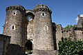 A gate in the castle.
 -
 The keep of the castle.
 -
 The Renaissance gallery.
 -
 The Maison de l'Ange.
 -
 Half-timbered house.
 -
 Saint-Nicolas church.
 -
 A baroque altar in Saint-Jean-de-Béré church.


.jpg)

.jpg)
.jpg)
Performing arts
The Théâtre de Verre ("glass theatre") is the main venue for concerts and theatre. Châteaubriant also has a four-screen cinema and a school for music, dance and drama ([1]).
The town has a Celtic circle and a bagad (Breton traditional band).
Local legends


Several legends are linked with Châteaubriant. The most famous one is the Bête de Béré ("Béré beast"), known in the whole Pays de la Mée. According to the legend, a beast, looking like a wolf, a pig or a big cat, prowls every night in the Béré suburb to protect a young maid who has been locked for centuries under the priory.
Another legend is built around Jean de Laval and his wife Françoise de Foix, mistress of Francis I of France, who died in 1537 in the castle. At that time, a rumour said that she was killed by her jealous husband, who did not approve of her relationship with the King. Since then, a ghostly procession would walk in the castle at the death anniversary, every 16 October at midnight.
Twin cities
Châteaubriant is
 Radevormwald, Germany, since 1981
 Athlone, Ireland, since 1985
 Brabova, Romania, since 1990
 Tigzirt, Algeria (in process).
See also
References
- ^ "Répertoire national des élus: les maires" (in French). data.gouv.fr, Plateforme ouverte des données publiques françaises. 13 September 2022.
- ^ "Populations légales 2021". The National Institute of Statistics and Economic Studies. 28 December 2023.
- ^ a b "Comparateur de territoire: Aire d'attraction des villes 2020 de Châteaubriant (228)". INSEE. Retrieved 20 June 2022.
- ^ Unité urbaine 2020 de Châteaubriant (44304), INSEE
- ^ Buffé, Marcel (1983). Châteaubriant, une cité dans l'histoire - De la préhistoire à nos jours. Éditions Cid. p. 15.
- ^ L'histoire géologique de la Bretagne Archived 2012-04-05 at the Wayback Machine, Emmanuèle Savelli
- ^ Pays de Châteaubriant (ed.). "Voies routières, métro, tramway, bus, covoiturage". Archived from the original on 1 December 2007.
- ^ Ville de Châteaubriant (ed.). "Castelbus". Archived from the original on 28 December 2012. Retrieved 18 February 2013.
- ^ Bouvet, Christian (2002). Châteaubriant histoires. Histoire et patrimoine du pays de Châteaubriant. p. 18.
- ^ Noël, François-Joseph-Michel (1841). Dictionnaire français-latin, refait sur un plan entièrement neuf. Le Normant.
- ^ Auffray, Régis (2007). Le Petit Matao, dictionnaire gallo-français, français-gallo. Rue des Scribes.
- ^ a b Des villages de Cassini aux communes d'aujourd'hui: Commune data sheet Châteaubriant, EHESS (in French).
- ^ Buffé, Marcel (1983). Châteaubriant, une cité dans l'histoire - De la préhistoire à nos jours. Éditions Cid. p. 16.
- ^ a b Flohic, Jean-Luc; Brochard, Éric; Daboust, Véronique (1999). Le Patrimoine des communes de la Loire-Atlantique. Vol. 1. Flohic. p. 257.
- ^ Buffé, Marcel (1983). Châteaubriant, une cité dans l'histoire - De la préhistoire à nos jours. Éditions Cid. p. 17.
- ^ Buffé, Marcel (1983). Châteaubriant, une cité dans l'histoire - De la préhistoire à nos jours. Éditions Cid. p. 25.
- ^ a b Bouvet, Christian (2008). Châteaubriant - Histoire millénaire des noms de lieux et des rues. Histoire et patrimoine du pays de Châteaubriant. p. 6.
- ^ Ville de Châteaubriant (ed.). "Histoire de Châteaubriant" (in French). Archived from the original on 8 March 2011. Retrieved 12 November 2010.
- ^ a b c Base Mérimée: Ville Châteaubriant, Ministère français de la Culture. (in French)
- ^ Buffé, Marcel (1983). Châteaubriant, une cité dans l'histoire - De la préhistoire à nos jours. Éditions Cid. p. 99.
- ^ Châteaubriant.org (ed.). "Livre - Les bombardements de Châteaubriant" (PDF).
- ^ Population en historique depuis 1968, INSEE
- ^ Communauté de communes du Castelbriantais (ed.). "Châteaubriant".
- ^ Foire de Béré (ed.). "Quelques chiffres". Archived from the original on 8 February 2015. Retrieved 19 February 2013.
External links
- . Encyclopædia Britannica. Vol. 5 (11th ed.). 1911.
- Official website
- The Foire de Béré website
| International | |
|---|---|
| National | |
| Geographic | |