
Chinampa
Chinampa (

Although different technologies existed during the Post-classic and Colonial periods in the basin, chinampas have raised many questions on agricultural production and political development. After the Aztec Triple Alliance formed, the conquest of southern basin city-states, such as Xochimilco, was one of the first strategies of imperial expansion. Before this time, farmers maintained small-scale chinampas adjacent to their households and communities in the freshwater lakes of Xochimilco and Chalco. The Aztecs did not invent chinampas but rather were the first to develop it to a large scale cultivation.[3][4] Sometimes referred to as "floating gardens," chinampas are artificial islands that were created by interweaving reeds with stakes beneath the lake's surface, creating underwater fences.[5] A buildup of soil and aquatic vegetation would be piled into these "fences" until the top layer of soil was visible on the water's surface.[5]
When creating chinampas, in addition to building up masses of land, a drainage system was developed.[6] This drainage system was multi-purposed. A ditch was created to allow for the flow of water and sediments (likely including night soil).[7] Over time, the ditch would slowly accumulate piles of mud.[6] This mud would then be dug up and placed on top of the chinampas, clearing the blockage.[6] The soil from the bottom of the lake was also rich in nutrients, thus acting as an efficient and effective way of fertilizing the chinampas.[6][8] Replenishing the topsoil with lost nutrients provided for bountiful harvests. Embarcadero-Jiménez and colleagues tested the correlation between environmental parameters and bacterial diversity in the soil. It is speculated that a diverse array of bacteria can affect the nutrients in the soil. The results found that bacterial diversity was more abundant in cultivated soils than non-cultivated soils. Also, "the structure of the bacterial communities showed that the chinampas are a transition system between sediment and soil and revealed an interesting association of the S-cycle and iron-oxidizing bacteria with the rhizosphere of plants grown in the chinampa soil".[9]
Evidence from Nahuatl wills from late seventeenth-century
History
The earliest fields that have been securely dated are from the
Chinampa farms also ringed


The Aztecs built Tenochtitlan on an island around 1325. Issues arose when the cities' constant expansion eventually caused them to run out of room to build. As the empire grew, more sources of food were required. At times this meant conquering more land; at other times it meant expanding the chinampa system. With this expansion, chinampas' multiple crops per year became a large factor in the production and supply of food. Empirical records suggest that farmers had a relatively light tribute to pay compared to others because the annual tribute may have been only a fraction of the amount necessary for local needs.[21]
The extent to which Tenochtitlan depended on chinampas for its fresh food supply has been the topic of a number of scholarly studies.[22][23][24][25]
Among the crops grown on chinampas were
The word chinampa comes from the Nahuatl word chināmitl, meaning "square made of canes" and the Nahuatl locative, "pan." In documentation by Spaniards, they used the word camellones, "ridges between the rows."[28] However, Franciscan Fray Juan de Torquemada described them with the Nahua term, chinampa, saying "without much trouble [the Indians] plant and harvest their maize and greens, for all over there are ridges called chinampas; these were strips built above water and surrounded by ditches, which obviates watering."[29]
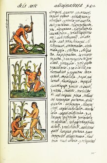
Chinampas are depicted in pictorial
There are still remnants of the chinampa system in Xochimilco, the southern portion of greater Mexico City. Chinampas have been promoted as a model for modern sustainable agriculture, although some sources have disputed the applicability of this model. One anthropologist, for instance, reports that attempts by Mexico to develop chinampas among the Chontal Maya people in the 1970s failed until the technicians modified their goals in order to suit the Chontales' interests.[34][clarification needed]
Construction:
According to Antonio Vera, through the UH Hilo website, within the framework of chinampas, there was two versions; inland and irrigated chinampas. Inland’s are created on banks, irrigated is built on water. Through steps, the structure of chinampas is to locate shallow land by the bank and surround said area with stakes of a common wetland tree [ahuejote]. The urbanization of Mexico lost this tradition and new challenges are created within the urbanization of Mexico. (https://hilo.hawaii.edu/nihopeku/2018/02/02/chinampa-an-ancient-agricultural-system/)
Modern chinampas

As of 1998, chinampas are still present in San Gregorio, a small town east of Xochimilco, in addition to San Luis, Tlahuac, and Mixquic.[35] Although many of these gardens were constructed and thoroughly tended to from the Postclassic Period through the Spanish conquest, many of these plots of land still exist and are in active use.[36][35]

Many of these chinampas have been allowed by present-day farmers to become overgrown.[35] Some choose to use canoes to farm, but many are becoming increasingly dependent on wheelbarrows and bicycles for transportation.[35] Other fields, such as some located in San Gregorio and San Luis areas, have been deliberately filled up.[35] As the canals dry up, several of the fields are naturally joined. Although not used for their original purpose, they are commonly used for cattle feed.[35]

Other fields, both dried and surrounded by canals, produce foods such as lettuce, cilantro, spinach, chard, squash, parsley, coriander, cauliflower, celery, mint, chives, rosemary, corn, and radishes.[35][37] The young leaves of quelites and quintoniles, which are often mistaken for weeds, are grown and harvested as ingredients of sauces.[35] Flowers also continue to be grown on these plots.[35] Some chinampa fields are also used as tourist sites.
Challenges
Although many locals and farmers are happy to return to their agricultural roots, they are faced with several challenges. During the Spanish conquest, many lakes were drained, limiting their agricultural capacity, such as the lake at Xochimilco.[38][39] In addition, in 1985 an earthquake struck, further damaging several canals.[38] Other challenges include limited water supply, the use of pesticides, climate change, urban sprawl, and water pollution caused by untreated sewage and toxic waste.[38][40][37]
See also
- Gardens portal
 Gardening portal
- Aquaponics
- Aquaculture
- Historical hydroculture
- Nanfang Caomu Zhuang, 4th-century Chinese record of floating gardens
- Waru Waru
References
- ISBN 9780195188431
- ^ "Chinampa Agriculture in the World Natural and Cultural Heritage Zone in Xochimilco, Tláhuac and Milpa Alta". www.fao.org. Retrieved 2022-09-19.
- ^ ISBN 978-92-808-0848-3.
- .
- ^ CiteSeerX 10.1.1.632.129.
- ^ S2CID 164138691.
- ^ Pedro Armillas, "Mesoamerica" in A History of Land Use in Arid Regions, L. Dudley Stamp, ed. Paris: UNESCO 1961, 266-67.
- ^ ISBN 0-679-83883-X
- S2CID 93334865.
- ^ Cline, Colonial Culhuacan, pp. 134-35.
- S2CID 42237687.
- ^ PMID 21876138.
- ISBN 0-06-014324-X
- ^ "Taxodium mucronatum". The Gymnosperm Database. Archived from the original on 2010-01-09. Retrieved 2009-10-12.
- ^ Cline, Colonial Culhuacan p. 2.
- ^ Richard Blanton, "Prehispanic Settlement Patterns of the Ixtapalapa Peninsula Region, Mexico." Ph.D. dissertation, University of Michigan 1970.
- ^ Since many of the chinampas regions show a uniformity of size and orientation, researchers such as Townsend assume they were constructed by "a planned program . . . over a short time". (p 167)
- .
- ^ Morehart, Christopher; Frederick, C. (Jun 2014). "The chronology and collapse of pre-Aztec raised field (chinampa) agriculture in the northern Basin of Mexico". Antiquity. 88 (340): 531–548 – via ResearchGate.
- ^ Charles Gibson, The Aztecs Under Spanish Rule. Stanford: Stanford University Press 1964.
- S2CID 154899887.
- S2CID 163995403.
- ^ Edward E. Calnek, "The Organization of Urban Food Supply Systems: The Case of Tenochtitlan" in Las ciudades de América Latina y sus áreas de influencia a través de la historia, Jorge Hardoy and Richard P. Schaedel, eds. Buenos Aires: Sociedad Interamericana de Planificación 1975.
- ^ Edward E. Calnek, "El sistema de mercado de Tenochtitlan," in Política e ideología en el México prehispánico," Pedro Carrasco and Johanna Broda, eds. Mexico: Editorial Nueva Imagen, 1978, pp. 97-114.
- ^ Jeffrey R. Parsons, "The Role of Chinampa Agriculture in the Food Supply of Aztec Tenochtitlan," in Cultural Change and Continuity, Charles Clelland, editor. New York: Academic Press 1976, 242.
- ^ Van Tuerenhout, Dirk R. (2005). The Aztecs: New Perspectives, p. 106. ABC-CLIO, Inc.
- ^ Teresa Rabiela Rojas, "Agricultural Implements in Mesoamerica," in Explorations in Ethnohistory, H.R. Harvey and Hanns J. Prem, eds. Albuquerque: University of New Mexico Press 1984
- ^ Cline, Colonial Culhuacan, p. 132.
- ^ Juan de Torquemada, Monarquia Indiana, vol. 2, 483. Mexico: Editorial Porrúa 1975.
- ^ Sigvald Linné, El valle y la ciudad de México en 1550. Relación histórico fundada sobre un mapa geográfico, que se conserva en la biblioteca de la Universidad de Uppsala [Sweden]. Stockholm 1948.
- S2CID 163995403.
- ^ S.L. Cline and Miguel León-Portilla, The Testaments of Culhuacan UCLA Latin American Center, Nahuatl Studies Series, vol. 1 1984.
- ^ Cline, Colonial Culhuacan
- PMID 12342093.
- ^ a b c d e f g h i Crossley, Philip (1999). "Virtual Field Trip". The Chinampas of Mexico. pp. 1–14. Retrieved October 1, 2017.
- ^ The Editors of Encyclopædia Britannica; Pauls, Elizabeth (December 8, 2006) [July 20, 1998]. "Chinampa". Encyclopædia Britannica. Retrieved October 1, 2017.
{{cite web}}:|last1=has generic name (help) - ^ a b Godoy, Emilio (February 27, 2016). "Mexico's Chinampas – Wetlands Turned into Gardens – Fight Extinction". Inter Press Service News Agency. Retrieved October 1, 2017.
- ^ a b c Tomky, Naomi (January 31, 2017). "Mexico's Famous Floating Gardens Return to Their Agricultural Roots". Smithsonian.com. Retrieved October 1, 2017.
- ^ Morehart, Christopher (2016). Ancient Mesoamerica. Cambridge University Press. p. 192.
- JSTOR 680550.
Sources
- Blanton, Richard. "Prehispanic Settlement Patterns of the Ixtapalapa Peninsula Region, Mexico." Ph.D. dissertation, University of Michigan 1970.
- Calnek, Edward E., "Settlement Pattern and Chinampa Agriculture," American Antiquity 1972, 37(104-15).
- Chapin, Mac. "The seduction of models: Chinampa agriculture in Mexico," Grassroots Development: Journal of the Inter-American Foundation Volume 12, no. 1, 1988, pp. 8–17.
- Cline, S.L., Colonial Culhuacan, 1580-1600: A Social History of an Aztec Town. Albuquerque: University of New Mexico Press 1986.
- Ezcurra, E. De las chinampas a la megalópolis: El Medio Ambiente en la Cuenca de México. Mexico City, SEP 1991.
- Parsons, Jeffrey R. "The Role of Chinampa Agriculture in the Food Supply of Aztec Tenochtitlan," in Cultural Change and Continuity, Charles Clelland, editor. New York: Academic Press 1976,
- Popper, Virginia. "Investigating Chinampa Farming." Backdirt (Cotsen Institute of Archaeology). Fall/Winter 2000.
- Rabiela, Teresa Rojas. "Chinampa Agriculture." In ISBN 9780195188431
- Townsend, Richard F. (2000) The Aztecs. revised ed. Thames and Hudson, New York.
External links
- Chinampas of Tenochtitlan - History of Urban Agriculture:
- Floating Gardens of Mexico City Archived 2020-04-19 at the Wayback Machine
- Chinampas 2.0 – an Elegant Technology From the Past to Save the Future. Rodrigo Laado. Permaculture Research Institute of Australia. May 28, 2013.
- http://hombresdemaiz.com.mx/v2/permacultura-mesoamericanamesoamerican-permaculture-chinampas-2-0-fundraising-edition Archived 2015-10-14 at the Wayback Machine
- Chinampas Gardens. Brianna. Midwest Permaculture. December 6, 2012.
- (in Spanish and English) Soy Xochimilco - CONABIO via YouTube
- Chinampas of Mexico - Andrew Millison on YouTube
| Gardening | |
|---|---|
| Types of gardens |
|
| Horticulture |
|
| Organic | |
| Plant protection | |
| Related articles | |