
Durnovaria
 Surviving fragment of the town walls of Durnovaria | |
 Location of Durnovaria within England | |
| Location | Dorchester, United Kingdom |
|---|---|
| Coordinates | 50°42′54″N 2°26′13″W / 50.715°N 2.437°W |
| Type | Roman city |
| History | |
| Founded | c. 70 AD |
| Abandoned | likely shortly after c. 410 AD |
| Periods | Roman Empire |
Durnovaria is a suggested spelling for the
Romans at Maiden Castle
The pre-Roman population centre in the area appears to have been at the
Roman Dorchester

The site of present-day Dorchester may have originally been a small garrison fort for the
Extant remains
The town still has some Roman features, including part of the town walls and the foundations of a Roman town house, which are freely accessible near County Hall. There are many Roman finds in the County Museum. The Romans built an aqueduct to supply the town with water, traces remain at nearby Whitfield Farm and approaching Poundbury tunnel on the Dorchester - Yeovil railway. Near the town centre is Maumbury Rings, an ancient British earthwork converted by the Romans for use as an amphitheatre, and to the north west is Poundbury Hill, another pre-Roman fortification.
Part of a Roman road, known today as High West Street, exists underneath the Dorset Museum, and a portion of it is displayed within the museum. The road ran through the centre of Durnovaria.
There is little evidence to show whether or not Durnovaria survived into the post-Roman era: Gildas' record of a tradition, given in De Excidio et Conquestu Britanniae iii, of twenty-eight cities and sundry castles of former happy times was not provided with any names. Surviving northern boundaries of the administrative region, or civitas that included Dorset, reached as far as Selwood, and mark the county division between Somerset and Wiltshire to this day.[9] In the sub-Roman period, as urban centres were progressively abandoned, the centres of administration and justice, such as they were, generally removed to fortified strongholds. The city's site is attested as Dornwaraceaster in the ninth century, elided to produce 'Dornaceaster, first recorded in 937.[10]
Gallery
-
 Roman ruins in Dorchester (Durnovaria), Dorset, England (Roman Town House)
 -
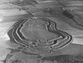 Excavations at Maiden Castle in October 1937. Photograph by Major George Allen (1891–1940).
 -
 Burials at the war cemetery at Maiden Castle, which date to the late Iron Age, c. 100 BC - 43 AD
 -
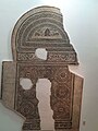 The 4th century Fordington mosaic from a town house in Durnovaria
 -
 Roman town house ruins
 -
 Preserved fragment of the Roman road that is known today as High West Street


Notes
- ^ "Welsh-English / English-Welsh On-line Dictionary".
- ^ http://www.smo.uhi.ac.uk/sengoidelc/duil-belrai/lorg.php?facal=fóir&seorsa=Gaidhlig [dead link]
- ^ "The fact is nowhere attested", C. E. Stevens noted in 1937, adding that Ptolemy, perhaps using a lost pre-occupation source, gives Durium (Geography ii.3.13) as the one town of the Durotriges,; see Stevens, "Gildas and the Civitates of Britain" The English Historical Review 52 No. 206 (April 1937:193-203) pp 202-03, note 3.
- ^ Sampled shafts in Greyhound Yard, Dorchester, in advance of rebuilding, published by Woodward et al., 1993, were reidentified as on-going ritual deposits, notably of sacrificed puppies and black carrion birds— crows, ravens and jackdaws— summarised by Peter Woodward and Ann Woodward, "Dedicating the Town: Urban Foundation Deposits in Roman Britain" World Archaeology 36.1 (March 2004:68-86) and compared with other Romano-British sites.
- ^ Details are in R.J.C. Smith, Excavations at County Hall, Dorchester, Dorset, 1988, in the North-West Quarter of Durnovaria, (Wessex Archaeology Report 4) Salisbury 1993.
- .
- ^ D. J. Smith, "The mosaic pavements", in A.L.F. Rivet, ed., The Roman Villa in Britain (1969:71-125).
- ^ Hogger, Harry. "Dorchester named as one of the happiest towns in country". Dorset Echo. Dorset Echo. Retrieved 28 July 2022.
- ^ Bruce Eagles, "Britons and Saxons on the Eastern Boundary of the Civitas Durotrigum" Britannia 35 (2004:234-240) passim traces clues of identifiable former tribal arrangements reflected in the eastern Roman and post-Roman boundary.
- ^ Anton Fägersten, Place-Names in Dorset (Uppsala) 1933:1-2, noted by F. M. Stenton, "Presidential Address: The Historical Bearing of Place-Name Studies; England in the Sixth Century" Transactions of the Royal Historical Society 4th Ser., 21 (1939:1-19) p. 6 note 1.
Further reading
- Breeze, A., "Durnovaria, the Roman name of Dorchester", Notes & Queries for Somerset & Dorset 35.4 pp 69–72.
- Trevarthen, M. (2008), Suburban life in Roman Durnovaria: Excavations at the former County Hospital Site, Dorchester, Dorset 2000–2001, Trust for Wessex Archaeology, ISBN 978-1874350460
- Durham, E. and Fulford, M. (2014) A Late Roman Town House and its Environs: The Excavations of C.D. Drew and K.C. Collingwood Selby in Colliton Park, Dorchester, Dorset 1937-8. London: Society for the Promotion of Roman Studies.
External links
![]() Media related to Durnovaria at Wikimedia Commons
Media related to Durnovaria at Wikimedia Commons