
Engineer Mountain
| Engineer Mountain | |
|---|---|
 Southeast aspect | |
| Highest point | |
| Elevation | 12,968 ft (3,953 m)[1] |
| Prominence | 1,408 ft (429 m)[1] |
| Parent peak | Rolling Mountain (13,693 ft)[2] |
| Isolation | 4.74 mi (7.63 km)[2] |
| Coordinates | 37°41′57″N 107°48′24″W / 37.6992257°N 107.8067202°W[3] |
| Geography | |
 Engineer Mountain Location in Colorado  Engineer Mountain Engineer Mountain (the United States) | |
| Location | Northeast Ridge |
Engineer Mountain is a 12,968-foot-elevation (3,953-meter) mountain summit located in
Topographic relief is significant as the southwest aspect rises 3,800 feet (1,200 meters) above Cascade Creek in approximately two miles. Neighbors include Snowdon Peak seven miles to the east, and Twilight Peak
, five miles to the southeast.
Climate
According to the Köppen climate classification system, Engineer Mountain is located in an alpine subarctic climate zone with long, cold, snowy winters, and cool to warm summers.[5] Due to its altitude, it receives precipitation all year, as snow in winter, and as thunderstorms in summer, with a dry period in late spring. Precipitation runoff from the mountain drains into tributaries of the Animas River.
Gallery
-
 Northeast aspect
 -
 View of the summit from Northeast Ridge
 -
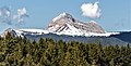
 Southeast aspect
 -
 Aerial view, with Coal Bank Pass to right side
 -
 West aspect
 -
 North aspect
 -


.jpg)


See also
References
- ^ a b "Engineer Mountain, Colorado". Peakbagger.com.
- ^ a b c "Engineer Mountain - 12,968' CO". listsofjohn.com. Retrieved 2021-07-05.
- ^ a b "Engineer Mountain". Geographic Names Information System. United States Geological Survey, United States Department of the Interior. Retrieved 2021-07-05.
- ISBN 9781493014637, page 45.
- ISSN 1027-5606.
External links
- Weather forecast: Engineer Mountain
- Engineer Mountain drone video: YouTube
Places adjacent to Engineer Mountain | ||||||||||||||||
|---|---|---|---|---|---|---|---|---|---|---|---|---|---|---|---|---|
| ||||||||||||||||