
Hallett Peak
| Hallett Peak | |
|---|---|
.jpg) Hallett Peak reflected in Lake Haiyaha at sunrise | |
| Highest point | |
| Elevation | 12,720 ft (3,877 m)[1][2] |
| Prominence | 733 ft (223 m)[3] |
| Isolation | 1.97 mi (3.17 km)[3] |
| Coordinates | 40°18′11″N 105°41′09″W / 40.3030699°N 105.6859415°W[1] |
| Naming | |
| Etymology | William L. Hallett |
| Geography | |
 Hallett Peak | |
| Location | Continental Divide in Rocky Mountain National Park between Grand and Larimer counties, Colorado, U.S.[4] |
| Parent range | Front Range |
| Topo map | USGS 7.5' topographic map McHenrys Peak, Colorado[1] |
| Climbing | |
| Easiest route | hike |
Hallett Peak (
Mountain
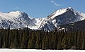
Hallett Peak is on the Continental Divide, flanked by Flattop Mountain to the north and Otis Peak to the south. Just to its east lie Emerald Lake, Dream Lake, and Nymph Lake, access to which is usually from the Bear Lake Comfort Station.[5][6]
The
Etymology
The mountain is named for William L. Hallett (1856–1947), an outstanding mountain climber and one of the founders of the Rocky Mountain Club.[7] Hallett arrived in the Estes Park area as a young MIT-trained engineer on vacation in 1878. He became enamored with the area and decided to remain, and became a rancher based in Loveland, Colorado.[8] The mountain's toponym was officially adopted in 1932 by the United States Board on Geographic Names.[4]
In the Arapaho language the mountain is named bonoh'ooonoteyoo' or Thunder Peak.[9]
Climate
According to the Köppen climate classification system, Hallett Peak is located in an alpine subarctic climate zone with cold, snowy winters, and cool to warm summers.[10] Due to its altitude, it receives precipitation all year, as snow in winter and as thunderstorms in summer, with a dry period in late spring.
Gallery
-
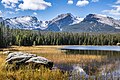 Otis Peak (left), Hallett Peak (center), Flattop Mountain (right)
 -
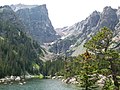 Looking west over Dream Lake. Hallett Peak is on the left with the dramatic cliff band and prominent point.
 -
 A view from Bierstadt Lake. Hallett Peak is at the center, flanked on the left by Otis Peak, with Flattop Mountain and Ptarmigan Point on the right.
 -
 Otis Peak (left) and Hallett Peak from northeast


See also
- List of Colorado mountain ranges
- List of Colorado mountain summits
- List of Colorado county high points
- List of peaks in Rocky Mountain National Park
References
- ^ a b c d "HALLETT TP". NGS Data Sheet. National Geodetic Survey, National Oceanic and Atmospheric Administration, United States Department of Commerce. Retrieved November 4, 2014.
- ^ NGVD 29 to NAVD 88.
- ^ a b c "Hallett Peak, Colorado". Peakbagger.com. Retrieved November 4, 2014.
- ^ a b c "Hallett Peak". Geographic Names Information System. United States Geological Survey, United States Department of the Interior. Retrieved November 4, 2014.
- ^ ISBN 0-87156-292-8.
- ^ ISBN 1-56044-334-0.
- ISBN 978-1-55566-333-9.
- ^ National Park Service, National Register of Historic Places Registration Form, Edgemont Hallett House
- ^ "Colorado Places: Their Native American Names". Center for Native American and Indigenous Studies (CNAIS). 2020-07-24. Retrieved 2024-01-12.
- ISSN 1027-5606.
External links
 Definitions from Wiktionary
 Media from Commons
 News from Wikinews
 Quotations from Wikiquote
 Texts from Wikisource
 Textbooks from Wikibooks
 Resources from Wikiversity
- "Hallett Peak". SummitPost.org.
- mountainproject.com
- rockclimbing.com