
Flat Tops (Colorado)
| The Flat Tops | |
|---|---|
| Flattops | |
 The Flat Tops as seen from State Highway 131 in Routt County | |
| Highest point | |
| Peak | Flat Top Mountain |
| Elevation | 12,361 ft (3,768 m) |
| Listing | Mountain ranges of Colorado |
| Coordinates | 39°55′45″N 107°18′17″W / 39.92915°N 107.30478°W |
| Geography | |
 The Flat Tops Location in Colorado | |
| Country | United States |
| State | Colorado |
| Parent range | Rocky Mountains |
The Flat Tops is a mountain range located in
The highest point in the Flat Tops is the summit of Flat Top Mountain (12,361 ft) on the east side of the range. The Devil's Causeway,[7] perhaps the most popular geologic feature and notorious hiking experience in the Flat Tops, is located in the same area. The Causeway is a narrow neck of the plateau where eroding glaciers on either side almost met. A trail crosses the Causeway which at its narrowest is 3 to 4 feet wide with drop-offs of hundreds of feet to the valleys on either side.
The eastern side of the Flat Tops Wilderness Area can be accessed by Routt County Rd 7 through the town of Yampa, Colorado.
The best-known destination approached from the west side of the range is Trappers Lake.
Gallery
-
 Flat Top Mountain, the highest peak in the Flat Tops (12,361 ft), overlooks Stillwater Reservoir.
 -
 The Devil's Causeway is a unique geological feature and popular hiking destination.
 -
 The layers of basalt that form the top of the plateau are exposed where glaciation has carved valleys.
 -
 A September sunrise highlights the basalt cliffs above Trappers Lake.
 -
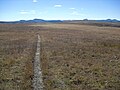 By late September the alpine flora on the plateau have turned brown. The distant peaks are part of the Flat Tops range.


References
- ^ White River National Forest
- ISBN 978-0-87842-609-6.
- ISBN 0-917895-38-X.
- ^ Flat Tops Wilderness Area
- ISSN 1387-3547.
- ISBN 0-9623868-8-X.
- ^ "Devils Causeway". www.rockymountainhikingtrails.com. Retrieved 16 Feb 2021.
External links
Denver (capital) | |
| Topics |
|
| Society | |
| Cities |
|
| Counties |
|
| Regions |
|