
Mount Emma
| Mount Emma | |
|---|---|
 The top of Mt. Emma can be seen centered (behind Greenback Mountain) | |
| Highest point | |
| Elevation | 13,581 ft (4,139 m)[1] |
| Prominence | 541 ft (165 m)[1] |
| Parent peak | Gilpin Peak (13,700 ft)[2] |
| Isolation | 0.82 mi (1.32 km)[2] |
| Coordinates | 37°58′30″N 107°47′25″W / 37.9748861°N 107.7904150°W[3] |
| Geography | |
 Mount Emma Location in Colorado  Mount Emma Mount Emma (the United States) | |
| Location | class 3[2] scrambling |
Mount Emma is a 13,581-foot-elevation (4,139-meter) mountain summit located in
U.S. Board on Geographic Names
.
Climate
According to the Köppen climate classification system, Mount Emma is located in an alpine subarctic climate zone with long, cold, snowy winters, and cool to warm summers.[5] Due to its altitude, it receives precipitation all year, as snow in winter, and as thunderstorms in summer, with a dry period in late spring. Precipitation runoff from the mountain drains into tributaries of the San Miguel River.
Gallery
-
 Gilpin Peak (left), Mount Emma (right)
 -
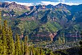 Mt. Emma upper right, Telluride below
 -
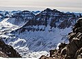 Mt. Emma to left of Gilpin Peak (viewed from Mt. Sneffels)
 -
 Mount Emma (centered) seen from golf course looking northeast


See also
References
- ^ a b c d "Mount Emma, Colorado". Peakbagger.com.
- ^ a b c d "Emma, Mount - 13,581' CO". listsofjohn.com. Retrieved 2021-07-01.
- ^ a b "Mount Emma". Geographic Names Information System. United States Geological Survey, United States Department of the Interior. Retrieved 2021-07-01.
- ISBN 9780871089977.
- ISSN 1027-5606.
External links
- Weather forecast: Mount Emma
- Emma Woodruff Hayden: Findagrave.com