
Mount Moss
| Mount Moss | |
|---|---|
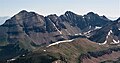
 Northeast aspect, centered (Lavender Peak to right) | |
| Highest point | |
| Elevation | 13,192 ft (4,021 m)[1][2] |
| Prominence | 272 ft (83 m)[2] |
| Parent peak | Lavender Peak (13,233 ft)[3] |
| Isolation | 0.23 mi (0.37 km)[2] |
| Coordinates | 37°26′20″N 108°04′42″W / 37.4389486°N 108.0782487°W[4] |
| Geography | |
 Mount Moss Location in Colorado  Mount Moss Mount Moss (the United States) | |
| Country | United States |
| State | class 2+[3] |
Mount Moss is a 13,192-foot-elevation (4,021-meter) mountain summit on the common boundary shared by La Plata County and Montezuma County in Colorado.[4]
Description
Mount Moss is located 16 miles (26 km) northwest of the community of
Hesperus Mountain 0.72 miles (1.16 km) to the northwest.[2]
Etymology
The mountain's toponym has been officially adopted by the
Parrott City which was six miles south of the peak. Moss and E.H. Cooper platted the townsite in 1874 and by 1876 it had 50 buildings, a courthouse and two sawmills.[6]
Climate
According to the Köppen climate classification system, Mount Moss has an alpine climate with cold, snowy winters, and cool to warm summers.[7] Due to its altitude, it receives precipitation all year, as snow in winter and as thunderstorms in summer, with a dry period in late spring.
Gallery
-
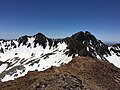 Mount Moss (left) and Lavender Peak (right) viewed from Centennial Peak
 -
 Aerial from west: Hesperus, Lavender, Moss
 -
 Hesperus Mountain (left) and Mount Moss (center) from the west at sunset


See also
References
- ISBN 9780967146607, p. 321.
- ^ a b c d e f "Mount Moss, Colorado". Peakbagger.com. Retrieved May 21, 2023.
- ^ a b "Moss, Mount - 13,194' CO". listsofjohn.com. Retrieved May 21, 2023.
- ^ a b c d "Mount Moss". Geographic Names Information System. United States Geological Survey, United States Department of the Interior. Retrieved May 21, 2023.
- ^ Ferdinand Vandeveer Hayden (1877), Ninth Annual Report of the United States Geological and Geographical Survey of the Territories, Embracing Colorado and Parts of Adjacent Territories, US Government Printing Office, p. 268.
- ^ Parrott City, Animasmuseum.org Retrieved May 21, 2023
- ISSN 1027-5606.
External links
- Weather forecast: Mount Moss
- John Thomas Moss (photo): Animasmuseum.org
Places adjacent to Mount Moss | ||||||||||||||||
|---|---|---|---|---|---|---|---|---|---|---|---|---|---|---|---|---|
| ||||||||||||||||