Fort Saint Vrain
Fort Saint Vrain | |
|---|---|
Trading post and fort | |
 Historical marker at the site of Fort Saint Vrain | |
| Nickname(s): Fort George, Fort Lookout | |
| Coordinates: 40°16′44″N 104°51′18″W / 40.27889°N 104.85500°W | |
| Country | United States |
| State | Colorado |
| County | Weld |
| Nearest town | Platteville |
| Elevation | 4,764 ft (1,452 m) |
Fort Saint Vrain was an 1837
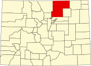
Weld County, Colorado. A historical marker notes the place where Old Fort St. Vrain once stood, today at the end of Weld County Road 40, located about seven miles north of Fort Vasquez, Colorado. Among those who helped to establish the fort was Ceran St. Vrain
, after whom it was named.
Bent's Old Fort
.
Marcellin St. Vrain, Ceran's brother, managed the
Sacajewea during the 1804-1806 Lewis and Clark Expedition
. She accompanied the expedition with her husband, trader & trapper Toussaint Charbonneau as well as newborn Jean Baptiste, while filling the crucial role of translator to the Shoshone Indian tribe.
After the Taos Revolt in 1847, the St. Vrain brothers both returned to St. Louis. After Ceran St. Vrain sold his shares of the Bent, St. Vrain Co., William Bent became sole proprietor by 1849. Bent moved to Fort St. Vrain temporarily before building a new Fort Bent in the Big Timbers area.
See also
- Bibliography of Colorado
- Geography of Colorado
- History of Colorado
- Index of Colorado-related articles
- List of Colorado-related lists
- Outline of Colorado
Notes
- ^ Elevation from the Geographic Names Information System.
References
- Whiteley, Lee; The Cherokee Trail: Bent's Old Fort to Fort Bridger; Lee Whiteley; 1999; Johnson Printing; Boulder, Colorado; ISBN 0-9671351-1-7
- Brotemarkle, Diane; Old Fort St. Vrain; Diane Brotemarkle; 2001; Johnson Printing; Boulder, Colorado; ISBN 0-9712372-0-4
- Ubbelohde, Carl; Benson, Maxine; Smith, Duane A; A Colorado History: Third Edition; 1972; Pruett Publishing Co; Boulder Colorado


