
Geography of Palau
 | |
| Continent | Pacific Ocean |
|---|---|
| Region | Oceania |
| Coordinates | 7°30′N 134°30′E / 7.500°N 134.500°E |
| Area | Ranked 179th |
| • Total | 459 km2 (177 sq mi) |
| • Land | 99% |
| • Water | 1% |
| Coastline | 1,519 km (944 mi) |
| Borders | None |
| Highest point | Mount Ngerchelchuus 242 metres (794 ft) |
| Lowest point | Pacific Ocean 0 m |
| Exclusive economic zone | 603,978 km2 (233,197 sq mi) |

The Republic of
Landform
The Palau archipelago contains more than 250 islands and islets stretched along a 150 km north south trending arc in the western Pacific. Its center is located near 7° north latitude, some 650 km north of Jaya on the island of New Guinea , and near 134° east latitude, some 900 km east of Mindanao, Philippines.
The geologically diverse archipelago is dominated by
Geology
The Palau Islands are composed chiefly of accumulated volcanic material and limestone. Geologists distinguish three geologic units of erupted
The rock islands, the platform islands and the eastern half of Oreor Island are made up of Palau limestone. The limestone is raised coralline reef structure which formed in the warm tropical waters during Miocene to Pleistocene times. Surrounding the volcanic islands are natural terraced benches resulting from sea level changes and uplifting of the Palau ridge. Two levels of natural terraced benches have been recognized. One bench is 1 m to 2 m above mean sea level, while a second, and much broader, bench is 5 to 10 m above mean sea level. Many villages on Babeldaob Island are built on this second bench. Geologic data indicate that Babeldaob Island has undergone a net uplift of land relative to sea level of about 2 m in the last 4000 years; thus, for most of the Palau coastline, submerged habitation sites in intertidal and coastal swamp areas are unlikely. Excepting a few calcareous sand beaches, the rock island edges rise abruptly out of the water, forming steep cliffs. Distinctive geologic features of the rock islands are shear cliffs and a notch cut back into the cliff just above mean sea level. [2]
Oceanography
Most of the Republic of Palau lies within the influence of both the North Equatorial Current (NEC, flowing east to west) and the Equatorial Countercurrent (ECC, flowing west to east). The influence of the NEC is strongest between November and May, when the trade winds prevail, and the ECC predominates the rest of the year. The Southwest Islands lie more deeply within the influence of the ECC. Sea surface temperatures range from 81 to 86 °F (27 to 30 °C) throughout the year. Subsurface temperatures to about 320 ft (100m) rarely fall below 79 °F (26 °C). Below this depth, the temperature drops quickly to less than 50 °F (10 °C) at approximately 590 ft - (180m). The constant heating of the ocean surface in the tropics creates a highly-stratified temperature regime in the water column, with little mixing. This general regime may vary locally or seasonally, as in the case of the upwelling of cold subsurface waters along steep leeward islands slopes.[3]
Soils
According to the 1983 Soil Conservation Service survey (Smith, 1983), there are roughly 18 kinds of soils in Palau, exhibiting a wide variety of texture, drainage, depth and fertility characteristics. To paraphrase the survey's summary, upland volcanic and limestone island soils are well-drained, limestone island soils excessively so. Upland volcanic island soils range from nearly level to very steep and are fine-textured, while bottom land soils are poorly drained or saturated. Limestone island soils may be either level, deep and sandy or steep, shallow and loamy in areas where they are associated with rock outcrops.[3]
Statistics
The area of Palau is slightly more than 2.5 times the size of the US city of Washington, DC.[1]
Maritime claims:
territorial sea:
12 nautical miles
exclusive economic zone:
603,978 km2 (233,197 sq mi) (200 nmi)
Elevation extremes:
lowest point:
Pacific Ocean 0 m
highest point:
Mount Ngerchelchauus 242 meters (794 ft) (on Babeldaob)
Land use:
arable land:
2.17%
permanent crops:
4.35%
other:
93.48% (2011)
Environment - international agreements:
party to:
Terrain varies geologically from the high, mountainous main island of
Climate
The climate of the Palau Islands is defined as being maritime tropical, characterized by little variation seasonally or diurnally. The country has a Köppen Climate Classification of Af (Tropical Rainforest Climate).[4] It rains almost daily. Short but torrential storms provide over 3.8m annually. Prolonged dry spells or droughts are rare. The northeast trade winds, usually blowing from December to July bring frequent rains and often a slightly drier time from February through April. The southwest trade winds are often associated with more violent storms. Although the Palau Islands are outside of the main typhoon zone, several damaging typhoons have struck the islands. The mean annual temperature is 27 °C, with a range in variation of less than 4 °C from the coolest months, January and February, to the warmest month, April. The daily variation averages only 6 °C. The humidity is very high, averaging 82% annually.[2]
| Climate data for Palau (Köppen Af) | |||||||||||||
|---|---|---|---|---|---|---|---|---|---|---|---|---|---|
| Month | Jan | Feb | Mar | Apr | May | Jun | Jul | Aug | Sep | Oct | Nov | Dec | Year |
| Mean daily maximum °C (°F) | 30.6 (87.1) |
30.6 (87.1) |
30.9 (87.6) |
31.3 (88.3) |
31.4 (88.5) |
31.0 (87.8) |
30.6 (87.1) |
30.7 (87.3) |
30.9 (87.6) |
31.1 (88.0) |
31.4 (88.5) |
31.1 (88.0) |
31.0 (87.7) |
| Daily mean °C (°F) | 27.3 (81.1) |
27.2 (81.0) |
27.5 (81.5) |
27.9 (82.2) |
28.0 (82.4) |
27.6 (81.7) |
27.4 (81.3) |
27.5 (81.5) |
27.7 (81.9) |
27.7 (81.9) |
27.9 (82.2) |
27.7 (81.9) |
27.6 (81.7) |
| Mean daily minimum °C (°F) | 23.9 (75.0) |
23.9 (75.0) |
24.1 (75.4) |
24.4 (75.9) |
24.5 (76.1) |
24.2 (75.6) |
24.1 (75.4) |
24.3 (75.7) |
24.5 (76.1) |
24.4 (75.9) |
24.4 (75.9) |
24.2 (75.6) |
24.2 (75.6) |
| Average rainfall mm (inches) | 271.8 (10.70) |
231.6 (9.12) |
208.3 (8.20) |
220.2 (8.67) |
304.5 (11.99) |
438.7 (17.27) |
458.2 (18.04) |
379.7 (14.95) |
301.2 (11.86) |
352.3 (13.87) |
287.5 (11.32) |
304.3 (11.98) |
3,758.3 (147.97) |
| Average rainy days | 19.0 | 15.9 | 16.7 | 14.8 | 20.0 | 21.9 | 21.0 | 19.8 | 16.8 | 20.1 | 18.7 | 19.9 | 224.6 |
| Mean monthly sunshine hours | 198.4 | 194.9 | 244.9 | 234.0 | 210.8 | 168.0 | 186.0 | 176.7 | 198.0 | 179.8 | 183.0 | 182.9 | 2,357.4 |
| Source: Hong Kong Observatory[5] | |||||||||||||
Vegetation
.svg)
The volcanic islands contain heavily eroded hills reaching heights of 250m above sea level, while the rock islands and atolls vary in elevation from sandy relict beaches a few meters above sea level to jagged limestone hills more than 200m high. The islands all are covered with dense stands of mixed tropical forest; in addition, the volcanic islands contain numerous areas of savanna and a broad belt of coastal mangrove swampland. An extensive barrier reef surrounds the central islands of the archipelago, forming a rich
Several types of forest communities can be observed in Palau.
Important resources in the gardens include several species of targ
Relief
The relief of the country varies from the hilly main island of Babeldaob to the low, coral islands, usually bordered by large barrier reefs. Average altitude - no data available; the lowest point is the water level of the Pacific Ocean (0 m); The highest point is Mount Ngerchelchuus (242 m).
-
 Relief of Palau
 -
 Ulong Island, Palau
 -
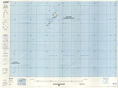
 Palau geography map
 -

-
 Aerial view of Babeldaob


Islands
- Palau Islands
-
 Angaur Island
 -
 Peleliu
 -
 Mecherchar
 -
 Map including most of the islands of Palau (DMA, 1991)


Extreme points
This is a list of the extreme points of Palau, the points that are farther north, south, east or west than any other location.
- Northernmost point – Ngaruangel Reef, Kayangel state*
- Easternmost point – Kayangel islet, Kayangel state
- Southernmost point – Helen Reef, Hatohobeistate
- Westernmost point - Tobi Island, Hatohobei state
- *Note: if submerged reefs are included then Velasco reef is Palau's northernmost point
External links
References
- ^ a b c d "Australia - Oceania :: Palau — The World Factbook - Central Intelligence Agency". www.cia.gov. Retrieved 2019-03-27.
- ^ a b c d e f Snyder, David.; Adams, William Hampton; Butler, Brian M. (1997). Archaeology and historic preservation in Palau. Anthropology research series / Division of Cultural Affairs, Republic of Palau 2. San Francisco: U.S. National Park Service.
- ^ a b Freifeld, Holly.; Otobed, Demei O.; Palau. (1997). A preliminary wildlife management plan for the Republic of Palau vertebrates. Koror: Division of Conservation/Entomology, Bureau of Natural Resources and Development, Republic of Palau.
- ^ "Koror, Palau Köppen Climate Classification (Weatherbase)". Weatherbase. Retrieved 2019-03-28.
- ^ "Climatological Information for Palau Islands, Pacific Islands, United States". Hong Kong Observatory. Archived from the original on 1 October 2018. Retrieved 20 May 2011.
![]() This article incorporates public domain material from The World Factbook.
This article incorporates public domain material from The World Factbook.
![]() This article incorporates public domain material from Snyder, David.; Adams, William Hampton; Butler, Brian M. (1997). Archaeology and historic preservation in Palau. Anthropology research series / Division of Cultural Affairs, Republic of Palau 2. San Francisco: U.S. National Park Service.
This article incorporates public domain material from Snyder, David.; Adams, William Hampton; Butler, Brian M. (1997). Archaeology and historic preservation in Palau. Anthropology research series / Division of Cultural Affairs, Republic of Palau 2. San Francisco: U.S. National Park Service.
![]() This article incorporates text from this source, which is in the public domain: A preliminary wildlife management plan for the Republic of Palau vertebrates
This article incorporates text from this source, which is in the public domain: A preliminary wildlife management plan for the Republic of Palau vertebrates