
Geography of Australia
Oceania (continent) | |
| Region | Oceania |
|---|---|
| Coordinates | 27°00′00″S 144°00′00″E / 27.000°S 144.000°E |
| Area | Ranked 6th |
| • Total | 7,688,287[1] km2 (2,968,464 sq mi) |
| • Land | 98.21% |
| • Water | 1.79% |
| Coastline | 59,681 km (37,084 mi) |
| Borders | None |
| Highest point | Mount Kosciuszko 2,228 m (7,310 ft) |
| Lowest point | Lake Eyre, −15 m (−49 ft) |
| Longest river | Murray River, 2,375 km (1,476 mi) |
| Largest lake | Lake Eyre 9,500 km2 (3,668 sq mi) |
| Climate | Mostly desert or semi-arid, south-east and south-west corners: temperate, north: tropical climate, varied between tropical rainforests, grasslands, part desert, mountainous areas: subantarctic tundra |
| Terrain | Mostly low plateau with deserts, rangelands and a fertile plain in the southeast; mountain ranges in the east and south-east. |
| Natural resources | Minerals, coal, and timber |
| Natural hazards | Cyclones along the northern coasts, severe thunderstorms, droughts, occasional floods, heat waves, and frequent bushfires |
| Exclusive economic zone | 8,148,250 km2 (3,146,060 sq mi) |
The
The countries that govern nearby regions include Indonesia, East Timor, and Papua New Guinea to the north; the Solomon Islands, Vanuatu, and the French dependency of New Caledonia to the east; and New Zealand to the southeast.
Physical geography

_(Oceania_centered)_with_borders.svg)
Australia is a
The Australian mainland has a total coastline length of 35,821 km (22,258 mi) with an additional 23,860 km (14,830 mi) of island coastlines.[2] There are 758 estuaries around the country with most located in the tropical and sub-tropical zones.[3] A recent global remote sensing analysis suggested that there was 8,866 km2 (3,423 sq mi) of tidal flat area in Australia, making it the third-ranked country in terms of how much tidal flat occurs there.[4] Australia has the third-largest exclusive economic zone of 8,148,250 km2 (3,146,060 sq mi). This EEZ does not include the Australian Antarctic Territory (an additional 5,896,500 km2 (2,276,700 sq mi)).
Australia has the largest area of ocean jurisdiction of any country on Earth.[5] It has no land borders. The northernmost points of the continental mainland are the Cape York Peninsula of Queensland and the Top End of the Northern Territory, but the northernmost point of the country lies in the Torres Strait Islands.
The western half of Australia consists of the Western Plateau, which rises to mountain heights near the west coast and falls to lower elevations near the continental centre. The Western Plateau region is generally flat, though broken by various mountain ranges such as the Hamersley Range, the MacDonnell Ranges, and the Musgrave Range. Surface water is generally lacking in the Western Plateau, although there are several larger rivers in the west and north, such as the Murchison, Ashburton, and Victoria rivers.
The Eastern Highlands, or
Between the Eastern Highlands and the Western Plateau lies the Central Lowlands, which are made up of the Great Artesian Basin and Australia's largest river systems, the
Off the north-eastern coast of Australia is the world's largest coral reef complex, the Great Barrier Reef. The large and mountainous island of Tasmania, also a State of Australia, lies south of the south-eastern corner of the Australian mainland. It receives abundant rainfall, and has highly fertile soils particularly in comparison to the mainland.
Geology

Australia is the lowest, flattest, and oldest continental landmass on Earth[6] and it has had a relatively stable geological history. Geological forces such as the tectonic uplift of mountain ranges and clashes between tectonic plates occurred mainly in Australia's early prehistory, when it was still a part of Gondwana. Its highest peak is Mount Kosciuszko at 2,228 m (7,310 ft), which is relatively low in comparison to the highest mountains on other continents.
Charles Rowland Twidale estimates that between 10% and 20% of Australia's modern landscapes formed during the Mesozoic when the continent was part of Gondwana.[7]
Australia is situated in the middle of the tectonic plate, and therefore currently has no active volcanism. Minor earthquakes which produce no damage occur frequently, while major earthquakes measuring greater than magnitude 6 occur on average every five years.
Regions
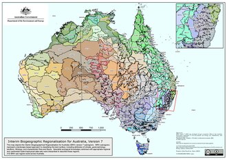
The Australian continental landmass consists of six distinct landform divisions.[9] These are:
- The Eastern Highlands—including the Great Dividing Range, the fertile Brigalow Belt strip of grassland behind the east coast, and the Eastern Uplands
- The Eastern alluvial Plains and Lowlands—the Murray Darling basin covers the southern part; also includes parts of the Lake Eyre Basin and extends to the Gulf of Carpentaria
- The South Australian Highlands—including the Flinders Range, Eyre Peninsula, and Yorke Peninsula
- The Western Plateau—including the Nullarbor Plain
- The Central Deserts
- Northern Plateau and Basins—including the Top End
Hydrology


Much of Australia's interior is arid; the low average annual rainfall and high temperatures mean interior rivers are often dry and lakes empty. The headwaters of some waterways are located in tropical regions where summer rains create a high rate of
The Great Artesian Basin is an important source of water, the world's largest and deepest fresh water basin. Access to water from the basin has led to the expansion of grazing into areas that were previously far too dry for livestock. Towns and cities across the country sometimes face major water storage and usage crises in which restrictions and other measures are implemented to reduce water consumption. Water restrictions are based on a gradient of activities that become progressively banned as the situation worsens.
Billabong is the Australian name given to the oxbow lakes that can form along a meandering river's course. In a worldwide comparison of height, Australia's waterfalls are relatively insignificant, with the longest drop ranked 135th according to the World Waterfall Database.[10]
Political geography
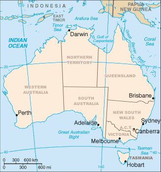
Australia consists of six states, two major mainland territories, and other minor territories. The states are
Australia also has several minor territories; the federal government administers a separate area within New South Wales, the Jervis Bay Territory, as a naval base and seaport for the national capital. In addition Australia has the following inhabited, external territories: Norfolk Island, Christmas Island, Cocos (Keeling) Islands, and several largely uninhabited external territories: Ashmore and Cartier Islands, Coral Sea Islands, and Heard Island and McDonald Islands. Australia also claims a portion of Antarctica as the Australian Antarctic Territory, although this claim is not widely recognized.
Human geography
This section needs expansion. You can help by adding to it. (January 2022) |
Australians have settled in several capital cities and their suburban satellites at various points along a vast coastline. A significant immigrant population occupied these places with relatively little dispute and few inner city ghettoes.[11] Australia’s mean population density is 3.3/km2, one of the lowest in the world.[12]
Sport plays an important social and cultural role in Australia with more than 90% of adults having an interest in sport.[13] English is the most common language in Australia. Australians enjoy a very high rate of private property ownership.[11] Australians have a preponderance to engage in gambling, experiencing the largest per capita losses in the world.[14]
Climate

By far the largest part of Australia is
Rainfall is highly variable, with frequent
Australia's tropical/subtropical location and cold waters off the western coast make most of western Australia a hot desert, with aridity a marked feature of the greater part of the continent. These cold waters produce little moisture needed on the mainland. A 2005 study by Australian and American researchers investigated the desertification of the interior, and suggested that one explanation was related to human settlers who arrived about 50,000 years ago. Regular burning by these settlers could have prevented monsoons from reaching interior Australia. The outback covers 70 percent of the continent.
Natural hazards
Environment

Current environmental issues include: soil erosion from overgrazing,
International agreements:
- party to: Tropical Timber 1994, Ramsar Convention, Whaling
- signed, but not ratified: Desertification


.jpg)
See also
- Australasian realm
- Australia-New Guinea
- List of cities in Australia by population
- List of extreme points of Australia
- List of islands of Australia
- List of lakes of Australia
- List of mountains in Australia
- List of regions of Australia
- List of rivers of Australia
- List of drainage basins of Australia
- List of valleys of Australia
- List of waterfalls of Australia
- Protected areas of Australia
References
- ^ "Area of Australia - States and Territories". 27 June 2014.
- ^ "Border Lengths – States and Territories". Geoscience Australia. Commonwealth of Australia. 2004. Retrieved 18 August 2016.
- ISBN 0-9586368-1-8.
- S2CID 56481043.
- ^ Non-Fisheries Uses in Australia's Marine Jurisdiction National Marine Atlas. Department of the Environment, Water, Heritage and the Arts
- ISBN 978-1-922103-43-7
- .
- ^ Mccue, Kevin (26 February 2010). "Land of earthquakes and volcanoes?". Australian Geographic. Archived from the original on 6 March 2010. Retrieved 25 April 2010.
- ISBN 0-09-130460-1.
- ^ "Significant Waterfalls". Geoscience Australia. Commonwealth of Australia. Archived from the original on 25 May 2010. Retrieved 11 June 2010.
- ^ ISBN 9780080970875. Retrieved 21 October 2022.
- S2CID 233552671.
- ^ "About sport in Australia". Department of Health and Aged Care. Commonwealth of Australia. 22 February 2022. Retrieved 22 October 2022.
- ^ "Gambling in Australia". Australian Institute of Health and Welfare. Retrieved 27 October 2022.
- ^ "Deserts". [. Commonwealth of Australia. Archived from the original on 5 December 2009. Retrieved 11 June 2010.
 This article incorporates public domain material from The World Factbook (2024 ed.).
Further reading
- Miller, Gifford; Mangan, Jennifer; Pollard, David; Thompson, Starley; Felzer, Benjamin; Magee, John (2005). "Sensitivity of the Australian Monsoon to insolation and vegetation: Implications for human impact on continental moisture balance". Geology. 33 (1): 65–68. doi:10.1130/G21033.1.
- "Highest Mountains". National Mapping – Fab Facts, Landforms, Australian Mountains. Archived from the original on 17 June 2005. Retrieved 7 July 2005.
- Weatherley, A.H., ed. (1967). Australian Inland Waters and their Fauna. Eleven Studies (PDF, 19Mb). Canberra: Australian National University Press. OCLC 594806492.
External links
- (in English and French) Map of Australia from 1826
 Wikimedia Atlas of Australia
- (in English) Water Usage in Australia