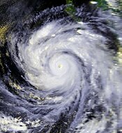
Hurricane Linda (1997)
 Linda at peak intensity to the south of Baja California on September 12 | |
| Meteorological history | |
|---|---|
| Formed | September 9, 1997 |
| Remnant low | September 17, 1997 |
| Dissipated | September 21, 1997 |
| Category 5 major hurricane | |
| 1-minute sustained (SSHWS/NWS) | |
| Highest winds | 185 mph (295 km/h) |
| Lowest pressure | 902 mbar (hPa); 26.64 inHg |
| Overall effects | |
| Fatalities | None |
| Damage | $3.2 million (1997 USD) |
| Areas affected | Socorro Island, Southwestern Mexico, Southern California |
| IBTrACS | |
Part of the 1997 Pacific hurricane season | |
Hurricane Linda was an extremely powerful
While near peak intensity, Hurricane Linda passed near
Meteorological history

Tropical storm (39–73 mph, 63–118 km/h)
Category 1 (74–95 mph, 119–153 km/h)
Category 2 (96–110 mph, 154–177 km/h)
Category 3 (111–129 mph, 178–208 km/h)
Category 4 (130–156 mph, 209–251 km/h)
Category 5 (≥157 mph, ≥252 km/h)
Unknown
The origins of Hurricane Linda are believed to have been in a
On becoming a tropical cyclone, the depression moved northwestward at 6 and 12 miles per hour (9.7 and 19.3 km/h), partially under the influence of a

Shortly after reaching peak intensity, Hurricane Linda passed near Socorro Island as a Category 5 hurricane.
Forecasters and computer models did not anticipate how quickly Linda would strengthen; in one advisory, the NHC under-forecast how strong the winds would be in 72 hours by 115 miles per hour (185 km/h).[7] The maximum potential intensity for Linda was 880 millibars (26 inHg), 22 millibars (0.65 inHg) lower than its actual intensity.[8] The 1997 season was affected by the 1997–98 El Niño event, which brought warmer than normal water temperatures and contributed to the high intensity of several storms. Hurricane Linda occurred about a month after the similarly powerful Hurricane Guillermo, which also reached Category 5 status. The passage of Linda cooled the waters in the region, causing Hurricane Nora to weaken when it passed through the area on September 21.[5]
Preparations and impact

Although the eye of Hurricane Linda did not make

When Linda was predicted to turn towards the northeast, it was forecast to move ashore in Southern California as a weak tropical storm, which would have made Linda the first to do so since a tropical storm in 1939.[3][10] The Oxnard, California National Weather Service office issued public information and special weather statements that discussed the possible impact of Linda on southern California. The advisories mentioned forecasting uncertainty, and advised the media not to exaggerate the storm.[1] The office noted a threat for significant rainfall—possibly causing flash flooding—as well as high surf.[4] To prepare for possible flooding, workers cleaned storm drains and prepared sandbags for coastal properties.[11]
Although the storm did not make the turn, 15 and 18 feet (4.6 and 5.5 m) waves reached southern California.
Records
With an estimated minimum central pressure of 902 millibars (26.6 inHg), Hurricane Linda became the most intense Pacific hurricane since reliable records began in
See also
- Other tropical cyclones named Linda
- List of California hurricanes
- List of Pacific hurricanes
- Timeline of the 1997 Pacific hurricane season
References
- ^ a b c d e f g h i j k l m n Mayfield, Britt M (1997-10-25). "Hurricane Linda Tropical Cyclone Report" (PDF). United States National Hurricane Center. Archived (PDF) from the original on 2016-12-22. Retrieved 2016-06-09.
- ^ National Hurricane Center (2007-09-10). "Glossary of NHC terms". Archived from the original on 2011-06-28. Retrieved 2008-12-25.
- ^ a b c d e f "A History of Significant Weather Events in Southern California" (PDF). National Weather Service Forecast Office San Diego. January 2007. Archived (PDF) from the original on 2016-01-20. Retrieved 2008-12-26.
- ^ a b c Jesse Ferrell (1997). "Hurricane Linda: History in the Making". Central Atlantic Storm Investigators. Archived from the original on September 28, 2007. Retrieved 2008-12-26.
- ^ from the original on 2018-11-05. Retrieved 2011-11-15.
- ^ Jack Williams (2005-05-17). "For a while, hurricane seemed aimed at California". USAToday.com. Archived from the original on 2011-01-23. Retrieved 2008-12-26.
- S2CID 122970092.
- .
- ^ Staff Writer (1997-09-14). "Hurricane hits Mexican ports, may be headed to California". Reuters.
- ^ Duginski, Paul (August 22, 2019). "Could a hurricane lash Los Angeles? 80 years ago, this deadly storm came close". Los Angeles Times. Archived from the original on August 27, 2019. Retrieved August 28, 2019.
- ^ Steve Schmidt (1997-09-15). "Fears ease as Pacific hurricane veers off". Copley News Service.
- ^ San Diego National Weather Service (2007-11-20). "Day in Weather History: September 14" (PDF). Archived from the original (PDF) on 2009-02-25. Retrieved 2008-12-26.
- ^ National Agricultural Statistics Service (1997-09-23). "Weekly Weather and Crop Bulletin" (PDF). United States Department of Agriculture. Archived from the original (PDF) on 2012-02-14. Retrieved 2008-12-27.
- ^ a b National Hurricane Center; Hurricane Research Division; Central Pacific Hurricane Center (April 4, 2023). "The Northeast and North Central Pacific hurricane database 1949–2022". United States National Oceanic and Atmospheric Administration's National Weather Service. A guide on how to read the database is available here.
 This article incorporates text from this source, which is in the public domain.
- ^ Miles B. Lawrence and Michelle M. Mainelli (2001-11-30). "Hurricane Juliette Tropical Cyclone Report". National Hurricane Center. Archived from the original on 2008-10-06. Retrieved 2008-12-26.

