
Jamnith
| Jamnith | |
|---|---|
| Jabnith; Jamnia; Kh. Banit | |
 Photo of Safed taken in 1948 from atop Mount Canaan (near Kh. Banit) | |
| Nearest city | Safed |
| Coordinates | 32°59′29″N 35°31′01″E / 32.99139°N 35.51694°E |
| Established | Hellenistic period (?) |
Jamnith (
The village is mentioned twice in the writings of
The fate of the town's defenders is not known, but they are presumed to have surrendered after the fall of Tarichaea.[3]
Victor Guérin visited the site in the late 19th-century and found on the plateau of the elevated hill, which he called Kharbet Benit, what he described as "a village, now overthrown from top to bottom, and of which there are only many piles of stones from demolished houses."[4] Earlier, in 1838, the site was visited by Edward Robinson, who wrote, "here (Benit) are the slight remains of a former village, situated directly on the brow of the mountains enclosing the Huleh, and commanding a splendid view over the whole basin and the surrounding region."[5]
Michael Avi-Yonah thought that the priestly course known as Bilgah had its place of residence in Yavnit.[6]

Identification
While most modern historical geographers are unanimous as to Jamnith's identification with the ruin Kh. Banit,[7][8][9][10][11][12][13] Edward Robinson and Eli Smith who surveyed the ancient sites of Palestine were uncertain of its location.[14] Neubauer thought that the site of Jamnia in Galilee may have been identical with Yabneel of the Hebrew Bible (Joshua 19:33), a place later known as Kefar Yammah.[15] However, this last site is not in the Upper Galilee.
Jamnia, known as Ibnit, had been resettled by local Arabs as late as 1948.[16]

Rabbinic burial ground
Jewish tradition holds that
Gallery
-
 View of Har Yavnit from east
 -
 Old footpath leading up to Jamnith (Kh. Banit)
 -
 Alleged burial cave of Abaye and Rava
 -
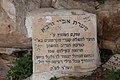 Stone inscription at alleged burial site of Abaye and Rava
 -
 Visitors' observation point on Har Yavnit
 -
 Shrine built as memorial to R. Yudan Nesiah, Har Yavnit
 -
 Modern stone structure at Har Yavnit, made from reused stones found at Kh. Banit
 -
 View from Har Yavnit, looking north


References
- OCLC 14912218.
- Vita188 (s. 37)
- ^ Josephus, The Jewish War, iv.1. "After the fall of Jotapata some of the Galilaeans had remained in revolt against Rome; but when Tarichaea was overthrown they surrendered, and the Romans took over all the fortresses and towns except Gischala and the garrison of Mt Tabor."
- ^ Guérin 1880, p. 439.
- ^ Robinson, E.; Smith, E. (1856), p. 434; cf. pp. 439, 449-450, 575
- JSTOR 23614642.; on this priestly ward, see Mishnah Sukkah 5:8, Tosefta Sukkah 4:28, and 1 Chronicles 24:14
- ^ Avi-Yonah 1976, p. 67.
- ^ Aviam 2004, p. 93 (chapter 9).
- ^ Har-el 1972, pp. 123–130.
- ^ Bar-Kochva 1974, p. 109 (map).
- ^ Conder & Kitchener 1881, p. 206.
- ^ Thomsen 1966.
- ^ Klein 1939, p. 163.
- ^ Robinson & Smith 2015, p. 74.
- ^ Neubauer 1868, p. 225.
- ^ OCLC 745203905.
- ^ Zissil: Encyclopedia of Kivrei Tzadikim. This view, however, is disputed, as another source puts the burial site of Abaye and Rava in Banias, about which, see: Levi-Naḥum, Yehuda (1986), p. 248, s.v. בעאם (sic); should be corrected to read בניאס.
- Judah HaNasi, is also called R. Yudan Nesi'ah.
- ^ Levi-Naḥum, Yehuda (1986), p. 252, chapter: Tombs of the forefathers and righteous [3], s.v. באבנית
Bibliography
- Aviam, Mordechai (2004). Jews, Pagans and Christians in the Galilee (Land of Galilee 1). Rochester: University of Rochester Press. ISBN 1-58046-171-9.
- JSTOR 43587090.
- Bar-Kochva, Bezalel (1974). "Notes on the Fortresses of Josephus in Galilee". JSTOR 27925451.
- Conder, C.R.; Kitchener, H.H. (1881). The Survey of Western Palestine: Memoirs of the Topography, Orography, Hydrography, and Archaeology. Vol. 1. London: Committee of the Palestine Exploration Fund.
- Guérin, V. (1880). Description Géographique Historique et Archéologique de la Palestine (in French). Vol. 2: Galilée, pt. 3. Paris: L'Imprimerie Nationale.
- Har-el, M. (1972). "The Zealots' Fortresses in Galilee". JSTOR 27925338.
- OCLC 18115508.
- Levi-Naḥum, Yehuda (1986). Sefer ṣohar le-ḥasifat ginzei teiman (in Hebrew). Ḥolon, Israel: Mifʻal ḥaśifat ginze Teman. OCLC 15417732.
- Neubauer, A. (1868). Géographie du Talmud (in French). Paris: Michel Lévy Frères.
- OCLC 640235350.
- ISBN 978-1-108-07990-7.
- Thomsen, Peter (1966). Loca Sancta. Hildesheim: Olms. (first printed in Leipzig 1907)
External links
- Survey of Western Palestine, Map 4: IAA, Wikimedia commons