
Mount Kenya
| Mount Kenya | |
|---|---|
| Geography | |
 Mount Kenya | |
MYA | |
| Climbing | |
| First ascent | 13 September 1899 by Mackinder, Ollier, and Brocherel, although the peoples of Kenya believed God (Ngai in Gikuyu) resided on this mountain and regularly ascended the peaks to perform spiritual rites.[4] |
| Easiest route | Rock climb |
Mount Kenya (
Mount Kenya is a volcano created approximately 3 million years after the opening of the East African Rift.[7] Before glaciation, it was 7,000 m (23,000 ft) high. It was covered by an ice cap for thousands of years. This has resulted in very eroded slopes and numerous valleys radiating from the peak.[8][9] There are currently 11 small glaciers, which are shrinking rapidly, and may disappear by 2050.[10] The forested slopes are an important source of water for much of Kenya.[11]
There are several vegetation bands from the base to the peak.[12] The lower slopes are covered by different types of forest. Many alpine species are endemic to Mount Kenya, such as the giant lobelias and senecios and a local subspecies of rock hyrax.[13] An area of 715 km2 (276 sq mi) around the centre of the mountain was designated a National Park and listed as a UNESCO World Heritage Site in 1997.[14] The park receives over 16,000 visitors per year.[15][11]
Mount Kenya National Park

Mount Kenya National Park, established in 1949, protects the region surrounding the mountain. Currently, the national park is within the forest reserve which encircles it.[16] In April 1978 the area was designated a UNESCO Biosphere Reserve.[17] The national park and the forest reserve, combined, became a UNESCO World Heritage Site in 1997.[14]
The Government of Kenya had four reasons for creating a national park on and around Mount Kenya. These were the importance of tourism for the local and national economies, preserving an area of great scenic beauty, conserving the biodiversity within the park, and preserving the water catchment for the surrounding area.[11]
Kenya's government has announced a project to discourage animals from straying into small holdings surrounding the Park and devastating crops. The project will see the Park enclosed by an electric fence with five electrified strands. Kenya's Rhino Ark Trust, a non-profit organization, has been putting up fences in key areas around the country. As of 2021, 250 kilometres (160 miles) out of a planned 450 kilometres (280 miles) have been constructed in the Mt. Kenya area.[18] The fence discharges an electric shock, but is not dangerous to humans or animals.[19]
Local culture

The main ethnic groups living around Mount Kenya are
. The first three are closely related. They all see the mountain as an important aspect of their cultures. All these cultures arrived in the Mount Kenya area in the last several hundred years.Kikuyu

The
The Kikuyu name for Mt. Kenya is Kĩrĩnyaga which literally means ‘the one with the ostrich’. The ostrich has black or brownish–grey feathers with patches of white. The Kikuyu attributed an ostrich's likeness to an object that was dark-coloured with white patches. The name Kĩrĩnyaga therefore figuratively means ‘the one with white patches’, referring to the glaciers among the peaks of the mountain.
Translated to the Kamba language, kĩrĩnyaga, would be ki nyaa. This is the name that Ludwig Krapf was given when he sighted the mountain from Kitui (in Kamba country). He recorded it as Kenya. It became the name of not only the mountain but also the country.[21]
Embu
The
Ameru
The
Maasai

The Maasai are semi-nomadic people, who use the land to the north of the mountain to graze their cattle.[25] They believe that their ancestors came down from the mountain at the beginning of time.[20] The Maasai name for Mount Kenya is Ol Donyo Keri, which means 'mountain of stripes', referring to the dark shades as observed from the surrounding plains.[26] At least one Maasai prayer refers to Mount Kenya:
God bless our children, let them be like the olive tree of Morintat, let them grow and expand, let them be like Ngong Hills like Mt. Kenya, like Mt. Kilimanjaro and multiply in number.
— Collected by Francis Sakuda of Oloshoibor Peace Museum[26]
Geology


Mount Kenya is a
The lower slopes of the mountain have never been glaciated. They are now mainly cultivated and forested. They are distinguished by steep-sided V-shaped valleys with many tributaries. Higher up the mountain, in the area that is now moorland, the valleys become U-shaped and shallower with flatter bottoms. These were created by glaciation.[27]
When Mount Kenya was
The rocks that form Mount Kenya are mainly basalts, rhomb porphyrites, phonolites, kenytes and trachytes.[27] Kenyte was first reported by Gregory in 1900 following his study of the geology of Mount Kenya.[28]
The geology of the Mount Kenya area was first described scientifically by
Peaks

The peaks of Mount Kenya are almost all of volcanic origin. The majority of the peaks are located near the centre of the mountain. These peaks have an Alpine appearance due to their craggy nature. Typically of Alpine terrain, the highest peaks and gendarmes occur at the intersection of ridges.[9] The central peaks only have a few mosses, lichens, and small alpine plants growing in rock crevices.[13] Further away from the central peaks, the volcanic plugs are covered in volcanic ash and soils.[31] The vegetation growing on these peaks is typical for their vegetation band.
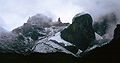
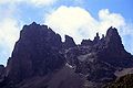
The highest peaks are Batian (5,199 m or 17,057 ft), Nelion (5,188 m or 17,021 ft) and Pt Lenana (4,985 m or 16,355 ft). Batian and Nelion are within 250 m (270 yd) of each other, separated by the Gate of the Mists gap of 5,144 m (16,877 ft).[3][32]
Other peaks around the central plug include Pt Piggot (4,957 m or 16,263 ft), Pt Dutton (4,885 m or 16,027 ft), Pt John (4,883 m or 16,020 ft), Pt John Minor (4,875 m or 15,994 ft), Krapf Rognon (4,800 m or 15,748 ft), Pt Peter (4,757 m or 15,607 ft), Pt Slade (4,750 m or 15,584 ft) and Midget Peak (4,700 m or 15,420 ft). All of these have a steep pyramidal form.[3][9]
Significant craggy outlying peaks include Terere (4,714 m or 15,466 ft) and Sendeyo (4,704 m or 15,433 ft) which form a pair of twin peaks to the north of the main plug. Together, they form a large parasitic plug. Other notable peaks include The Hat (4,639 m or 15,220 ft), Delamere Peak, Macmillan Peak and Rotundu.[3]
-
 Batian on the left, Nelion on the right, and Slade in the foreground
 -
 Lenana, the third highest peak, is the most ascended
 -
 Mount Kenya, left to right: Point Lenana (4985m), Nelion summit (5188), Batian summit (5199m)
 -
 Krapf Rognon (4,800 m or 15,748 ft) and Krapf glacier
 -
![Midget peak can be climbed in a day.[33]](//upload.wikimedia.org/wikipedia/commons/thumb/f/fa/Hut_tarn_4500m_and_Midget_Peak_Mt_Kenya.JPG/120px-Hut_tarn_4500m_and_Midget_Peak_Mt_Kenya.JPG) Midget peak can be climbed in a day.[33]
Midget peak can be climbed in a day.[33] -
 Terere and Sendeyo are two craggy outlying peaks
 -
![Mugi hill and the Giant's Billiards Table offers some of the best hillwalking in Kenya.[20]](//upload.wikimedia.org/wikipedia/commons/thumb/e/e2/Mugi_hill_and_giants_billards_table.jpg/120px-Mugi_hill_and_giants_billards_table.jpg) Mugi hill and the Giant's Billiards Table offers some of the best hillwalking in Kenya.[20]
Mugi hill and the Giant's Billiards Table offers some of the best hillwalking in Kenya.[20] -
 Nelion from Batian in Dec 1974
 -
 Looking down the Diamond Glacier to Pt John


![Midget peak can be climbed in a day.[33]](/File:Hut_tarn_4500m_and_Midget_Peak_Mt_Kenya.JPG)

![Mugi hill and the Giant's Billiards Table offers some of the best hillwalking in Kenya.[20]](/File:Mugi_hill_and_giants_billards_table.jpg)


Glaciers

The glaciers on Mount Kenya are retreating rapidly. The Mountain Club of Kenya in Nairobi has photographs showing the mountain at the time of the first recorded ascent in 1899, and again more recently; the retreat of the glaciers is very evident.[34][35] Descriptions of ascents of several of the peaks advise the use of crampons, but this is true only in some cases and at higher elevations. Every year there is less new snow accumulating in winter than melting in summer, even on the Lewis Glacier (the largest of them) in winter, so there is no formation of new ice. It is predicted to be less than 30 years before there will no longer be ice on Mount Kenya.[20] Glacial retreat and disappearance can be caused by changes in temperature trends, or by a change in precipitation trends.[36]
The glacier names are (clockwise from the north):
- Northey, Krapf, Gregory, Lewis, Diamond, Darwin, Forel, Heim, Tyndall, Cesar, Josef.

The total area covered by glaciers on the mountain was recorded as about 0.7 km2 (1⁄4 sq mi) in the 1980s,[37] far less than that recorded by the first observations, made in the 1890s.
Periglacial landforms
Although Mount Kenya is on the
Rivers

Mount Kenya is the main water catchment area for two large rivers in Kenya; the Tana, the largest river in Kenya, and the Ewaso Nyiro North.[11] The Mount Kenya ecosystem provides water directly for over 2 million people.[11] The rivers on Mount Kenya have been named after the villages on the slopes of the mountain that they flow close to. The Thuchi River is the district boundary between Tharaka Nithi and Embu. Mount Kenya is a major water tower for the Tana river which in 1988 supplied 80% of Kenya's electricity using a series of seven hydroelectric power stations and dams.[38]
The density of streams is very high, especially on the lower slopes which have never been glaciated. The ice cap which used to cover the mountain during the Pliocene eroded large U-shaped valleys which tend to only have one large stream.[9] Where the original shape of the
The gradual transition from glaciated to the fluvial valley can be clearly observed.[40]Rivers that start on Mount Kenya are the tributaries of two large Kenyan rivers: the Tana and the Ewaso Ng'iro rivers. A lot of Mount Kenyan rivers flow into the Sagana which itself is a tributary of the Tana, which joins at the Masinga Reservoir. The rivers in the northern part of the mountain, such as the Burguret, Naru Moru, Nanyuki, Likii, and Sirimon flow into the Ewaso Nyiro. The rivers to the southwest, such as the Keringa and Nairobi flow into the Sagana and then into the Tana. The remaining rivers to the south and east, such as the Kathitâ (Largest River in Meru), Mutonga, Nithi, Thuchi, and Nyamindi, flow directly into the Tana.[39][40]
Natural history
Mount Kenya has several altitudinal ecological zones, from the savanna surrounding the mountain to the nival zone by the glaciers. Each zone has a dominant species of vegetation. Many of the species found higher up the mountain are endemic, either to Mount Kenya or East Africa.[13]
There are also differences within the zones, depending on the side of the mountain and the aspect of the slope. The southeast is much wetter than the north,[37] so species more dependent on moisture can grow. Some species, such as African alpine bamboo, are limited to certain aspects of the mountain because of the amount of moisture.[3]
Zones

The climate of Mount Kenya changes considerably with altitude, forming belts of community types.[41] Around the base of the mountain is fertile farmland. The people living around the mountain have cultivated this cool relatively moist area for centuries.[42]
Mount Kenya is surrounded by forests. The vegetation in the forests depend on rainfall, and the species present differ greatly between the northern and southern slopes.[43] As time has passed the trees on the edge of the forest have been logged and the farmland has encroached further up the fertile slopes of the mountain.[41][42]
Above the forest is a belt of African alpine bamboo. This zone is almost continuous but is restricted to small isolated bunches in the north because of low rainfall. The bamboo is natural,[33] and does not require forest disturbance. Tracks are common through the bamboo. Bamboo suppresses other vegetation, so it is uncommon to find trees or other plants here.[3]

Above the bamboo is the timberline forest. The trees here are often smaller than the trees in the forests lower down the mountain.[44] The forest here is more intact because it is less accessible and better protected.
When the trees can no longer grow the vegetation changes into
As the altitude increases the temperature fluctuations become extreme and the air becomes thinner and drier. This region is known as the
The region where the glaciers have recently retreated from is
Flora
The flora found on Mount Kenya varies with altitude, aspect, and exposure.[46] As the altitude increases, the plants have to be more specialised, with adaptations to strong sunlight with ultraviolet, lower mean temperatures, and freezing night temperatures.[33][44]
Plants in the Afro-alpine zone have overcome these difficulties in several ways.[45] One adaptation is known as the giant rosette, which is exhibited by giant senecio, giant lobelia, and giant thistle (Carduus), which use bud leaves to protect their buds from freezing. Giant rosette senecios form single-aged stands that drive community structure over decades.[47]
Many plant species in the Afro-alpine zone of Mount Kenya are giant versions of lowland (or temperate) relatives. However, nearer the nival zone the plants decrease in size again.[13]

Fauna
The majority of animals live lower down on the slopes of Mount Kenya. Here there is more vegetation and the climate is less extreme. Various species of monkeys, several antelopes, tree hyrax, porcupines, and some larger animals such as elephants and buffalo all live in the forest.[3] Predators found here include hyenas and leopards, and occasionally lions.[3]
There are fewer mammals found at high altitudes on Mount Kenya.
Other mammal species are only occasional visitors. Remains of elephants, monkeys, and bongo have been found high in the alpine zone,[48] and other sightings are remembered in names such as Simba Tarn (simba means lion in Swahili).[33]
Several bird species live in the Afro-alpine zone, including
Climate
The climate of Mount Kenya has played a critical role in the development of the mountain, influencing the topography and ecology amongst other factors. It has a typical equatorial mountain climate which Hedberg described as winter every night and summer every day.[50] Mount Kenya is home to one of the Global Atmosphere Watch's atmospheric monitoring stations.[51]
Seasons

The year is divided into two distinct
The current climate on Mount Kenya is wet, but drier than it has been in the past. The temperatures span a wide range, which diminishes with altitude. In the lower alpine zone temperature usually do not go below 12 °C (54 °F).[55] Snow and rain are common from March to December, but especially in the two wet seasons. The wet seasons combined account for 5/6 or 83% of the annual precipitation. The monsoon, which controls the wet and dry seasons, means that for most of the year there are south-easterly winds, but during January and February the dominant wind direction is north-easterly.[citation needed]
Mount Kenya, like most locations in the tropics, has two wet seasons and two dry seasons as a result of the monsoon. From mid-March to June the heavy rain season, known as the long rains, brings approximately half of the annual rainfall on the mountain.[42] This is followed by the wetter of the two dry seasons which lasts until September. October to December are the short rains when the mountain receives approximately a third of its rainfall total. Finally from December to mid-March is the drier dry season when the mountain experiences the least rain.[citation needed]
Daily pattern
During the dry season, the mountain almost always follows the same daily weather pattern. Large daily temperature fluctuations occur which led Hedberg to exclaim winter every night and summer every day.[50] There is variation in minimum and maximum temperatures day to day, but the standard deviation of the mean hourly pattern is small.[citation needed]

A typical day is clear and cool in the morning with low humidity. The mountain is in direct sunlight which causes the temperatures to rise quickly with the warmest temperatures occurring between 09:00 and 12:00. This corresponds to a maximum in the pressure, usually around 10:00. Low on the mountain, between 2,400 and 3,900 m (7,874 and 12,795 ft), clouds begin to form over the western forest zone, due to moist air from
Being an equatorial mountain the daylight hours are constant with twelve-hour days. Sunrise is about 06:30 with the sun setting at 18:30 (both EAT = UTC+3). Over the year there is a one-minute difference between the shortest and longest days.[57] At night, the sky is usually clear with katabatic winds blowing down the valleys. Above the lower alpine zone there is usually frost every night.[55]
History
European documentation

The first European to report seeing Mount Kenya was Dr Johann Ludwig Krapf, a German missionary, from Kitui,[58] a town 150 km (90 mi)[5] away from the mountain. The sighting was made on 3 December 1849,[43] a year after the first sighting of Mount Kilimanjaro by a European.[59]
Krapf was told by the Embu people that lived around the mountain that they did not ascend high enough on the mountain because of the intense cold and the white matter that rolled down the mountains with a loud noise. This led him to infer that glaciers existed on the mountain.[58] It was Krapf who gave the mountain the name "Kenya", but the derivation of this is not known with certainty.[citation needed]

Krapf also noted that the rivers flowing from Mount Kenya, and other mountains in the area, were continuously flowing. This was very different from the other rivers in the area, which swelled up in the wet season and completely dried up after the rainy season had ended. As the streams flowed even in the driest seasons he concluded that there must be a source of water up on the mountain, in the form of glaciers.[58] He believed the mountain to be the source of the White Nile.[60]
In 1851 Krapf returned to Kitui. He travelled 65 kilometres (40 mi) closer to the mountain, but did not see it again. In 1877 Hildebrandt was in the Kitui area and heard stories about the mountain, but also did not see it. Since there were no confirmations to back up Krapf's claim people began to be suspicious.[30]
Eventually, in 1883, Joseph Thomson passed close by the west side of the mountain and confirmed Krapf's claim. He diverted his expedition and reached 1,737 m (5,700 ft) up the slopes of the mountain but had to retreat because of trouble with local people.[29] However, the first European exploration high onto the mountain was achieved in 1887 by Count Sámuel Teleki. He managed to reach 4,350 m (14,270 ft) on the southwestern slopes.[61] On this expedition Teleki mistakenly believed he had found the crater of a volcano.
In 1892, Teleki and von Höhnel returned to the eastern side but were unable to get through the forest.[13]
Finally, in 1893, an expedition managed to ascend Mount Kenya as far as the glaciers. This expedition was traveling from the coast to Lake Baringo in the Rift Valley and was led by Dr. John W Gregory, a British geologist. They managed to ascend the mountain to around 4,730 m (15,520 ft) and spent several hours on the Lewis Glacier with their guide. On his return to Britain, Gregory published papers and a narrative account of his achievements.[33]
George Kolb, a German physician, made expeditions in 1894 and 1896[33] and was the first to reach the moorlands on the east side of the mountain. More exploration occurred after 1899 when the Uganda Railway was completed as far as the future site of Nairobi.[33][62]
Mackinder's expedition
On 28 July 1899,
Mackinder pushed on up the mountain and established a camp at 3,142 m (10,310 ft)[62] in the Höhnel Valley. He made his first attempt on the summit on 30 August with Ollier and Brocherel up the southeast face, but they had to retreat when they were within 100 m (330 ft) of the summit of Nelion due to nightfall.
On 5 September, Hausberg, Ollier, and Brocherel made a circuit of the main peaks looking for an easier route to the summit. They could not find one. On 11 September Ollier and Brocherel made an ascent of the Darwin Glacier, but were forced to retreat due to a blizzard.[62]
When Saunders returned from Naivasha with the relief party, Mackinder had another attempt at the summit with Ollier and Brocherel. They traversed the Lewis Glacier and climbed the southeast face of Nelion. They spent the night near the
During the expedition, Mackinder ordered for 8 of the 90 African porters, who he had bought from a slave owner to carry his supplies, to be shot.[63]
1900–1930

After the first ascent of Mount Kenya, there were fewer expeditions there for a while. The majority of the exploration until after the
New approach routes were cleared through the forest, which made access to the area of the peak far easier. In 1920, Arthur and Sir Fowell Buxton tried to cut a route in from the south, and other routes came in from Nanyuki in the north, but the most commonly used was the route from the Chogoria mission in the east, built by Ernest Carr. Carr is also credited with building Urumandi and Top Huts.[33]
On 6 January 1929, the first ascent of Nelion was made by Percy Wyn-Harris and Eric Shipton. They climbed the Normal Route, then descended to the Gate of Mists before ascending Batian. On 8 January they reascended, this time with G. A. Sommerfelt, and in December Shipton made another ascent with R. E. G. Russell. They also made the first ascent of Point John. During this year the Mountain Club of East Africa was formed.[33]
At the end of July 1930, Shipton and Bill Tilman made the first traverse of the peaks. They ascended by the West Ridge of Batian, traversed the Gate of Mists to Nelion, and descended the Normal Route. During this trip, Shipton and Tilman made the first ascents of several other peaks, including Point Peter, Point Dutton, Midget Peak, Point Pigott, and either Terere or Sendeyo.[64]
1931 to present day
In the early 1930s, there were several visits to the moorlands around Mount Kenya, with fewer as far as the peaks. Raymond Hook and Humphrey Slade ascended to map the mountain, and stocked several of the streams with trout. By 1938 there had been several more ascents of Nelion. In February, Miss C Carroll and Mtu Muthara became the first woman and African respectively to ascend Nelion, in an expedition with Noel Symington, author of The Night Climbers of Cambridge, and on 5 March Miss Una Cameron became the first woman to ascend Batian.[33]
During the
In 1949 the Mountain Club of Kenya split from the Mountain Club of East Africa, and the area above 3,400 m (11,150 ft) was designated a National Park.[33] A road was built from Naro Moru to the moorlands, allowing easier access.
Many new routes were climbed on Batian and Nelion in the next three decades, and in October 1959 the Mountain Club of Kenya produced their first guide to Mount Kenya and Kilimanjaro.
On 19 July 2003, a South African registered aircraft, carrying 12 passengers and two crew, crashed into Mount Kenya at Point Lenana; nobody survived.[68][69] This was not the first aircraft lost on the mountain; there is also the wreckage of at least one helicopter that crashed before 1972.[70]
In March 2012 a massive fire raged on Mount Kenya, devouring thousands of hectares of ancient forests and endangered wildlife.[71]
Mountaineering
Climbing routes

Most of the peaks on Mount Kenya have been summited. The majority of these involve rock climbing as the easiest route, although some only require a scramble or a walk. The highest peak that can be ascended without climbing is Point Lenana, 4,985 m (16,355 ft).[33][64] The majority of the 15,000 visitors to the national park each year climb this peak. In contrast, approximately 200 people summit Nelion and 50 summit Batian, the two highest peaks.[20]
When ascended directly, Batian is usually climbed via the North Face Standard Route,
Mount Kenya's climbing seasons are a result of its location only 20 km (12 mi) from the equator. During the northern summer, the rock routes on the north side of the peak are in good summer condition, while at the same time, the ice routes on the south side of the peak are in prime shape. The situation is reversed during the southern summer. The two seasons are separated by several months of the rainy season before and after, during which climbing conditions are generally unfavorable.[citation needed]
Mount Kenya is home to several good ice routes, the two most famous being the Diamond Couloir and the Ice Window route. Snow and ice levels on the mountain have been retreating at an accelerated rate in recent years, making these climbs increasingly difficult and dangerous. The Diamond Couloir, a steep ice couloir fed by the fusion of the upper Diamond Glacier, was first climbed by National Park staff Phil Snyder and Thumbi Mathenge in October 1973. A direct finish was pioneered in 1975 by Yvon Chouinard and Michael Covington[74] The couloir was once climbable in summer or winter but now is virtually unclimbable in summer conditions and is seldom deemed in climbable condition even in winter.[75] Last climbing reports describe the route very difficult, especially in the lower section. The route has changed into a modern ice climb with a very difficult 60m first pitch, starting with 8m of overhanging M7 dry tooling, followed by 50m of USA Grade V ice and by 6 pitches of moderate climbing on good ice and finally one pitch of water ice USA Grade IV+ ice at the headwall before getting to the Upper Diamond Glacier.
The satellite peaks around the mountain also provide good climbs. These can be climbed in
Walking routes

There are eight walking routes up to the main peaks. Starting clockwise from the north these are the: Meru, Chogoria, Kamweti, Naro Moru, Burguret, Sirimon, and Timau Routes.[3] Of these Chogoria, Naro Moru, and Sirimon are used most frequently and therefore have staffed gates. The other routes require special permission from the Kenya Wildlife Service to use.[20][76]
The Chogoria route leads from
The Naro Moru route is taken by many of the trekkers who try to reach Point Lenana. It can be ascended in only 3 days and has bunkhouses at each camp. The route starts at Naro Moru town to the west of the mountain and climbs towards Mackinder's Camp before joining the Peak Circuit Path.[76] The terrain is usually good, although one section is called the Vertical Bog.[33]
The Sirimon route approaches Mount Kenya from the northwest.[3] The path splits on the moorlands, with the more frequently used fork following the Mackinder Valley and the quieter route traversing into the Liki North Valley.[3] The paths rejoin at Shipton's Cave just below Shipton's Camp on the Peak Circuit Path.[33]
The Peak Circuit Path is a path around the main peaks, with a distance of about 10 km (6 mi) and height gain and loss of over 2,000 m (6,600 ft).[3] It can be walked in one day, but more commonly takes two or three. It can also be used to join different ascent and descent routes. The route does not require technical climbing.[64][76]
-
 The Gorges Valley is a major feature on the Chogoria Route.
 -
 Vertical bog on Mount Kenya on the Naro Moru Route.
 -
 Looking towards the peaks up the Mackinder Valley on the Sirimon Route.


Recent development
Development is currently underway for a new route up the mountain starting from the Ragati conservancy and running up the ridge between the Naro Moru route and the old Kamweti trail.
Accommodation
Accommodation on Mount Kenya ranges from very basic to luxurious. The more luxurious lodges are found on the lower slopes, in and around the forest.[77][78] These lodges have hotel-style accommodation, often with log fires and hot running water.[79][80] Many offer guided walks and other activities such as fishing and birdwatching.
The huts higher on the mountain are more basic. Most have several
-
![Austrian Hut is found near the Lewis Glacier on the slopes of Point Lenana. The hut sleeps 30 people, with Top Hut nearby for porters.[33]](//upload.wikimedia.org/wikipedia/commons/thumb/d/db/Mt_kenya_austrian_hut_with_nelion.jpg/84px-Mt_kenya_austrian_hut_with_nelion.jpg) Austrian Hut is found near the Lewis Glacier on the slopes of Point Lenana. The hut sleeps 30 people, with Top Hut nearby for porters.[33]
Austrian Hut is found near the Lewis Glacier on the slopes of Point Lenana. The hut sleeps 30 people, with Top Hut nearby for porters.[33] -
![Liki North Hut is a small bothy in the Liki North Valley.[33] It offers little more than shelter from the weather.](//upload.wikimedia.org/wikipedia/commons/thumb/a/a4/Mt_kenya_liki_north_hut.jpg/120px-Mt_kenya_liki_north_hut.jpg)
-
![Shipton's Camp is at the top of the Sirimon Route.[64] It has a large communal area and running cold water.](//upload.wikimedia.org/wikipedia/commons/thumb/6/61/Mt_kenya_shiptons_camp_with_sendeyo.jpg/120px-Mt_kenya_shiptons_camp_with_sendeyo.jpg) Shipton's Camp is at the top of the Sirimon Route.[64] It has a large communal area and running cold water.
Shipton's Camp is at the top of the Sirimon Route.[64] It has a large communal area and running cold water. -
![Camping is allowed anywhere within the National Park.[20]](//upload.wikimedia.org/wikipedia/commons/thumb/a/ab/Mount_Kenya_14200ft_camp.jpg/90px-Mount_Kenya_14200ft_camp.jpg) Camping is allowed anywhere within the National Park.[20]
Camping is allowed anywhere within the National Park.[20] -
![Fairmont Mount Kenya Safari Club is a resort located in Nanyuki at the base of Mount Kenya. The resort has over 120 rooms and is one of the most exclusive in the region.[78]](//upload.wikimedia.org/wikipedia/commons/thumb/9/98/Fairmont_Mount_Kenya_Safari_Club_Resort.jpg/120px-Fairmont_Mount_Kenya_Safari_Club_Resort.jpg) Fairmont Mount Kenya Safari Club is a resort located in Nanyuki at the base of Mount Kenya. The resort has over 120 rooms and is one of the most exclusive in the region.[78]
Fairmont Mount Kenya Safari Club is a resort located in Nanyuki at the base of Mount Kenya. The resort has over 120 rooms and is one of the most exclusive in the region.[78]
![Austrian Hut is found near the Lewis Glacier on the slopes of Point Lenana. The hut sleeps 30 people, with Top Hut nearby for porters.[33]](/File:Mt_kenya_austrian_hut_with_nelion.jpg)
![Liki North Hut is a small bothy in the Liki North Valley.[33] It offers little more than shelter from the weather.](/File:Mt_kenya_liki_north_hut.jpg)
![Shipton's Camp is at the top of the Sirimon Route.[64] It has a large communal area and running cold water.](/File:Mt_kenya_shiptons_camp_with_sendeyo.jpg)
![Camping is allowed anywhere within the National Park.[20]](/File:Mount_Kenya_14200ft_camp.jpg)
![Fairmont Mount Kenya Safari Club is a resort located in Nanyuki at the base of Mount Kenya. The resort has over 120 rooms and is one of the most exclusive in the region.[78]](/File:Fairmont_Mount_Kenya_Safari_Club_Resort.jpg)
Etymology
The origin of the name Kenya is not clear but perhaps linked to the Kikuyu, Embu, and Kamba words Kirinyaga, Kirenyaa and Kiinyaa which mean "God's resting place" in all three languages.
In the 19th Century, the German explorer,
Names of peaks
The peaks of Mount Kenya have been given names from three different sources. Firstly, several Maasai chieftains have been commemorated, with names such as Batian, Nelion, and Lenana. They commemorate Mbatian, a Maasai
The second type of name that was given to peaks is after European climbers and explorers. Some examples of this are Shipton, Sommerfelt, Tilman, Dutton, and Arthur.[33]
The remaining names are after well-known Kenyan personalities, except John and Peter, which were named by the missionary Arthur after two disciples. There is a group of four peaks to the east of the main peaks named after European settlers; Coryndon, Grigg, Delamere, and McMillan.[33]
See also
References
- ^ a b c "Africa Ultra-Prominences" Peaklist.org. Retrieved 6 February 2012.
- ^ "Mount Kenya Map Sample". Ewpnet.com. Archived from the original on 21 August 2010. Retrieved 16 April 2010.
- ^ ISBN 978-0-906227-96-1. Archived from the originalon 27 February 2009.
- ^ ISBN 978-0-435-90219-3.
- ^ ISBN 1-84353-359-6.
- ^ "Where is Mount Kenya Located?". WorldAtlas. 8 June 2018.
- ^ Philippe Nonnotte. "Étude volcano-tectonique de la zone de divergence Nord-Tanzanienne (terminaison sud du rift kenyan) – Caractérisation pétrologique et géochimique du volcanisme récent (8 Ma – Actuel) et du manteau source – Contraintes de mise en place thèse de doctorat de l'université de Bretagne occidentale, spécialité : géosciences marines" (PDF).
- ^ a b
S2CID 129865997.
- ^ a b c d e f Baker, B. H. (1967). Geology of the Mount Kenya area. Nairobi: Geological Survey of Kenya.
- ^ TravelMedals (26 January 2020). "Mount Kenya Summit Challenge!". Travel Medals. Retrieved 26 May 2020.
- ^ a b c d e f Gichuki, Francis Ndegwa (August 1999). "Threats and Opportunities for Mountain Area Development in Kenya". Ambio. 28 (5): 430–435. Archived from the original (subscription required) on 31 December 2005.
- ISBN 978-0-345-41701-5.
- ^ a b c d e f g h i j Coe, Malcolm James (1967). The Ecology of the Alpine Zone of Mount Kenya. The Hague: Dr W. Junk.
- ^ a b "Mount Kenya National Park/Natural Forest". United Nations. 2008. Archived from the original on 30 December 2006. Retrieved 23 February 2008.
- ^ "World Heritage Nomination – IUCN Technical Evaluation Mount Kenya (Kenya)" (PDF).
- ^ "Mount Kenya National Park". Archived from the original on 25 January 2010. Retrieved 30 December 2009.
- ^ "Biosphere Reserve Information – Mount Kenya". UNESCO. 1998. Retrieved 6 November 2016.
- ^ Waita, Edwin (25 February 2021). "In Kenya, electric fences protect forests from human destruction". Reuters New Service.
- ^ "Mt Kenya to get electric fence to stop wildlife straying". BBC News. Bbc.co.uk. 7 September 2012. Retrieved 11 September 2013.
- ^ a b c d e f g h i j Kenya Wildlife Service (2006), Mount Kenya Official Guidebook, Kenya Wildlife Service
- ^ "Mount Kenya | volcano, Kenya". Encyclopedia Britannica. Retrieved 14 October 2020.
- S2CID 245928948.
- S2CID 198396394.
- S2CID 162608268.
- ISSN 0140-1963.
- ^ S2CID 144020233. Retrieved 21 February 2008.
- ^ a b c d e Baker, B. H. (1967). Geology of the Mount Kenya Area. Geological Survey of Kenya. Ministry of Natural Resources.
- ^ S2CID 219242189.
- ^ ISBN 978-1-141-95717-0.
- ^ a b c
ISBN 978-0-7146-1812-8.
- JSTOR 3672965.
- ^ "Mount Kenya Climbing guide". Ewpnet.com. Archived from the original on 14 February 2008. Retrieved 11 September 2013.
- ^ ISBN 978-9966-9856-0-6.
- ^ Mountain Club. "Mountain Club of Kenya Homepage". Retrieved 26 May 2007.
- ISBN 978-0-9729033-3-2, 144 pp.
- ISBN 978-0-340-58431-6.
- ^ a b Karlén, Wibjörn; James L Fastook; Karin Holmgren; Maria Malmström; John A Matthews; Eric Odada; Jan Risberg; Gunhild Rosqvist; Per Sandgren; Aldo Shemesh; Lars-Ove Westerberg (August 1999). "Glacier Fluctuations on Mount Kenya since ~6000 Cal. Years BP: Implications for Holocene Climate Change in Africa". Ambio. 28 (5): 409–418. Archived from the original on 31 December 2005.
- ^ JSTOR 3673659.
- ^ a b Geological Map of the Mount Kenya Area (Map) (1st ed.). 1:125000. Geological Survey of Kenya. Cartography by B. H. Baker, Geological Survey of Kenya. Edward Stanford Ltd. 1966. Archived from the original on 7 August 2011.
- ^ a b
Mt Kenya 1:50000 Map and Guide (Map) (1 ed.). 1:50000 with 1:25000 inset. Cartography by West Col Productions. Andrew Wielochowski and Mark Savage. 1991. ISBN 0-906227-39-9.
- ^ a b Hedberg, Olov (1951). "Vegetation belts of East African mountains". Svensk Bot. Tidskr. 45: 140–202.
- ^ ISBN 978-1-85339-253-5.
- ^ a b c Dutton, E.A.T. (1929). Kenya Mountain. London: Jonathan Cape.
- ^ a b Niemelä, Tuomo; Pellikka, Petri (2004). Zonation and characteristics of the vegetation of Mt. Kenya. Vol. 40. pp. 14–20. )
- ^ a b Hedberg, Olov (1964). "Features of Afroalpine Plant Ecology". Acta Phytogeographica Suecica. 49: 1–144.
- ^ .
- JSTOR 2261071.
- ^ a b Young, Truman P.; Evans, M.E. (1993). "Alpine vertebrates of Mount Kenya". Journal of the East African Natural History Society. 82 (202): 154–79.
- ISBN 978-0-8018-8221-0.
- ^ .
- S2CID 122971010.
- S2CID 118140053.
- .
- JSTOR 1788958.
- ^ S2CID 36783645.
- ISBN 978-90-277-1572-2.
- ^ "Sunset & sunrise calculator (altitude not taken into account)". Archived from the original on 20 February 2008. Retrieved 3 June 2007.
- ^ a b c d Krapf, Johann Ludwig (1860). Travels, Researches, and Missionary Labours in Eastern Africa. London: Frank Cass & Co. Ltd.
- JSTOR 1774261.
It was the missionary Rebmann of Mombasa who, in 1848, first reported the existence of Kilimanjaro. In the following year his colleague, Krapf, saw Kenya from Kitui, a spot 90 miles southeast of the peak.
- ^ Krapf, Johann Ludwig (13 May 1850). "Extract from Krapf's diary". Church Missionary Intelligencer. i: 345.
- ^ von Höhnel, Lieutenant Ludwig; Teleki, Count Samuel (1894). Discovery of Lakes Rudolf and Stefanie. London: Longmans.
- ^ JSTOR 1774261.
- ^ "Oxford Geography's Uncomfortable History". University of Oxford. School of Geography and the Environment, University of Oxford. 22 October 2019. Retrieved 17 May 2023.
- ^ ISBN 978-1-871890-98-3.
- ISBN 978-1-59228-724-6.
- ^ Brandt, Anthony (May 2004). "Extreme Classics: The 100 Greatest Adventure Books of All Time". National Geographic Adventure. Archived from the original on 2 September 2004. Additional pages archived on 22 July 2004: Page 1, Page 2, Page 3, Page 4, Page 5.
- ^ Kenya Broadcasting Corporation, 11 April 2007: An hero is laid to rest[permanent dead link]
- ^ Charter aircraft crashes into Kenya's Mount Kenya., Airline Industry Information, 21 July 2003
- ^ Rescue teams resume efforts to recover bodies of those killed in charter aircraft crash, Airline Industry Information, 23 July 2003
- ^ "Aircraft flown off Mount Kenya". News. The Times. No. 49451. London. 23 January 1943. col C, p. 3.
- ^ "Fire devours Kenya's ancient forests". Al Jazeera. Retrieved 11 September 2013.
- ^ "Mount Kenya Online Climbing Guide". Archived from the original on 14 February 2008. Retrieved 19 May 2009.
- ^ Alpine Journal Vol. 42
- ^ Iain Allan: The Mountain Club of Kenya Guide to Mount Kenya and Kilimanjaro (Nairobi; Mountain Club of Kenya, 1998) p107
- ^ "Diamond Couloir Still Climbable". Archived from the original on 19 January 2011. Retrieved 11 July 2010.
- ^ a b c "Mount Kenya Online Trekking Guide". Archived from the original on 17 December 2007. Retrieved 19 May 2009.
- ^ "Castle Forest Lodge". Archived from the original on 8 July 2011. Retrieved 19 May 2009.
- ^ a b "Fairmont Mount Kenya Safari Club". Retrieved 20 April 2017.
- ^ "Serena Mountain Lodge" (PDF). Archived from the original (PDF) on 19 October 2007. Retrieved 19 May 2009.
- ^ "Lake Rutundu Log Cabins on Mount Kenya". Archived from the original on 4 October 2007. Retrieved 19 May 2009.
- ^
Reader, John (1989). Mount Kenya. London: Elm Tree Books. ISBN 978-0-241-12486-4.
- ^ Krapf, Johann Ludwig (13 May 1850). "Extract from Krapf's diary". Church Missionary Intelligencer. i: 452.
- ISBN 978-1-84162-066-4.
- JSTOR 717465.
- ISBN 0307263487.
- ^ "Kenya". Oxford English Dictionary (Online ed.). Oxford University Press. (Subscription or participating institution membership required.)
Further reading
- Benuzzi, F. (1953). ISBN 978-1-59228-724-6.
- Best, Nicholas (2014). Point Lenana. Thistle Publishing/Kindle Single.
- ISBN 978-0-39333-556-9.
- Fadiman J. (1993). When We Began, There Were Witchmen An Oral History from Mount Kenya. University of California Press. ISBN 978-0-520-08615-9. Retrieved 28 June 2011.
- ISBN 978-0-394-70210-0.
- Mahaney, W.C. (1990). Ice on the Equator. Ellison Bay, Wisconsin, U.S.A: Wm Caxton Ltd. ISBN 978-0-940473-19-5. A full survey of the long glacial and periglacial reconstructive history of Mt. Kenya, its geological and environmental settings, sequences of paleosols (ancient soils) and their significance in understanding the multiplicity of glaciations.
External links
- "Mount Kenya National Park/Natural Forest". UNESCO World Heritage Centre. 2011. Retrieved 28 June 2011.
- "Mount Kenya Trust". Mount Kenya Trust. 2006. Archived from the original on 10 May 2015. Retrieved 28 June 2011.
- "Mt. Kenya National Park". Kenya Wildlife Service. 2011. Archived from the original on 25 January 2010. Retrieved 28 June 2011.
- "Mount Kenya, Kenya". Peakbagger.com. Retrieved 27 July 2013.
- "Mount Kenya Climbing Routes". 2014. Retrieved 1 October 2014.
| International | |
|---|---|
| National | |
| Other | |