Nisyros
Nisyros
Νίσυρος | |
|---|---|
UTC+3 (EEST) | |
| Postal code | 853 03 |
| Area code(s) | 22420 |
| Vehicle registration | ΚΧ, ΡΟ, ΡΚ |
| Website | www.nisyros.gr |
Nisyros also spelled Nisiros (
Its shape is approximately round, with a diameter of about 8 km (5 mi), and an area of 41.6 km2 (16.062 sq mi).[2] Several other islets are in the direct vicinity of Nisyros, the largest of which is Gyali, with a population of 22 citizens. The Municipality of Nisyros includes Gyalí, as well as uninhabited Pacheiá, Pergoússa, Kandelioussa, Ágios Antónios and Strongýli. It has a total land area of 50.055 km2 (19.326 sq mi)[3] and a total population of 1,048 inhabitants (2021). The island was also called Nisiro in Italian and İncirli in Turkish.
Geology


The island has a 3-to-4-kilometre (1.9 to 2.5 mi) wide
Geography
Nisyros can experience the Meltemi Etesian wind through June - August. This is most obvious on the eastern and western flanks of the volcano, where trees are bent towards the south from the force of the winds. The wind may be especially strong on the island due to jet effects as it passes over Kos.
Climate
According to the station of the
Settlements

The island is reachable by ship from
| Nisyros | |
|---|---|
| Νίσυρος | |
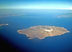
 Aerial view of Nisyros. Nisyros is the large island in the foreground. | |
| Highest point | |
| Elevation | 698 m (2,290 ft)[4] |
| Coordinates | 36°35′10″N 27°09′36″E / 36.586°N 27.160°E[4] |
| Geography | |
| Location | Aegean Sea, Greece |
| Geology | |
| Mountain type | Stratovolcano with a Caldera |
| Last eruption | September 1888[5] |
History

According to Greek mythology, the island was formed when Poseidon cut off a part of Kos and threw it onto the giant Polybotes to stop him from escaping. The ancient name of the Nisyros was Porphyris. Ancient walls, dating from the 5th century BC, part of the acropolis of the island, are found near Mandraki.
It was apparently also a source of
The island is mentioned by Homer in the Iliad.[9]
In Roman times it became part of the
Between X-XI centuries, Genoese captains and adventurers who had a private fleet organized in clans united by family ties, exercised sovereignty and maritime control on behalf of the
The Knights Hospitaller in 1315 were allowed to settle on the island upon payment of rent to Genoese government ruled by the Vignolo family, and they built the crusader castle.
In the following centuries there were clashes between Turks and Venetian crusaders, and with uncertain outcomes the island passed to the
Christianity
The
Diocese of Nisyrus
Nisyrus was a
Latin titular see
The diocese was nominally restored in 1927 as Titular See of the lowest (Episcopal) rank, initially named Nysirus (Curiate Italian Nisiro), and renamed Nisyrus in 1928.
It has been vacant for decades, having had the following incumbents:
- Francesco Fellinger (26 February 1929 – 22 July 1940)
- Augusto Osvaldo Salinas Fuenzalida, Picpus Fathers(SS.CC.) (9 February 1941 – 3 August 1950)
- Elizeu Simões Mendes (21 August 1950 – 19 September 1953)
- Carlos Maria Jurgens Byrne, Redemptorists (C.SS.R.) (7 February 1954 – 17 December 1956) (later Archbishop)
- Augusto Trujillo Arango (25 April 1957 – 31 March 1960) (later Archbishop)
- Auguste Joseph Gaudel (1 September 1960 – 8 August 1969)
Culture
A traditional product of Nisyros is
Twinning
Mandraki is twinned with the following municipalities:
 Lapithos, Cyprus
Notable natives and residents
- John Catsimatidis, New York City owner of Gristedes
See also
- List of volcanoes in Greece
- List of traditional Greek place names
References
- ^ "Αποτελέσματα Απογραφής Πληθυσμού - Κατοικιών 2021, Μόνιμος Πληθυσμός κατά οικισμό" [Results of the 2021 Population - Housing Census, Permanent population by settlement] (in Greek). Hellenic Statistical Authority. 29 March 2024.
- ^ "City of Nisyros". Municipality of Nisyros. Retrieved 2008-01-22.
- ^ "Population & housing census 2001 (incl. area and average elevation)" (PDF) (in Greek). National Statistical Service of Greece.
- ^ a b c d e "Nisyros: Summary". Global Volcanism Program. Smithsonian Institution.
- ^ a b "Nisyros: Eruptive History". Global Volcanism Program. Smithsonian Institution.
- ^ "Monthly Bulletins". www.meteo.gr.
- ^ "Latest Conditions in Nisyros".
- ^ M. J. T. Lewis, Millstone and Hammer: the origins of water power (University of Hull Press 1997), pp. vii 66-7.
- ^ 2.675-679
- ^ Catholic Hierarchy: "Bishop Pierre Fridaricus" retrieved January 30, 2016
- ^ Catholic Hierarchy: "Bishop Pedro Xague, O.P." retrieved January 30, 2016
- ^ Catholic Hierarchy: "Bishop Jerónimo Clavijo, O.P." retrieved January 30, 2016
- ^ Catholic Hierarchy: Diocese of Nisyros retrieved January 30, 2016
External links
- Official website (in English, French, German, Greek, Italian, and Spanish)
- Volcano World: Nisyros, Greece Archived 2012-04-23 at the Wayback Machine
- Photoblog from bRandSboRg.CoM

