
Panketal
Panketal | |
|---|---|
 Town hall | |
 Coat of arms | |
Location of Panketal within Barnim district  | |
Ortsteile | |
| Government | |
| • Mayor (2018–26) | Maximilian Wonke[1] (SPD) |
| Area | |
| • Total | 25.84 km2 (9.98 sq mi) |
| Elevation | 60 m (200 ft) |
| Population (2022-12-31)[2] | |
| • Total | 20,854 |
| • Density | 810/km2 (2,100/sq mi) |
| Time zone | UTC+01:00 (CET) |
| • Summer (DST) | UTC+02:00 (CEST) |
| Postal codes | 16341 |
| Dialling codes | 030 |
| Vehicle registration | BAR |
| Website | www.panketal.de |
Panketal is a municipality in the district of Barnim, in Brandenburg, Germany. It is situated 15 km northeast of Berlin (centre).
History
Panketal emerged in 2003 by merging the municipalities Zepernick and Schwanebeck. Since 1996, the population increased by 52.8%.[3]
From 1815 to 1947, the constituent localities of Panketal were part of the Prussian Province of Brandenburg, from 1947 to 1952 of the State of Brandenburg, from 1952 to 1990 of the East German Bezirk Frankfurt and since 1990 again of Brandenburg.
Demography
-
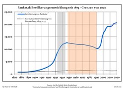 Development of Population since 1875 within the Current Boundaries (Blue Line: Population; Dotted Line: Comparison to Population Development of Brandenburg state; Grey Background: Time of Nazi rule; Red Background: Time of Communist rule)
 -
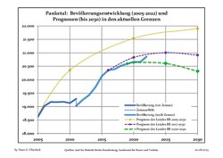 Recent Population Development and Projections (Population Development before Census 2011 (blue line); Recent Population Development according to the Census in Germany in 2011 (blue bordered line); Official projections for 2005-2030 (yellow line); for 2014-2030 (red line); for 2017-2030 (scarlet line)


|
|
|
Recreation
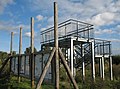
In 2006 a ropes course has been set up in the district Hobrechtsfelde. The ropes course has some 20 different training units. It was subsidized by Panketal with a total sum of 150,000 €.[5]
-
 Ropes course in theclimbing gardenat Hobrechtsfelde
 -
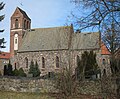 Church in Schwanebeck
 -
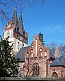 Church in Zepernick
 -
 Former granary in Hobrechtsfelde
 -
 View point in Hobrechtsfelde


References
- ^ Landkreis Barnim Wahl der Bürgermeisterin / des Bürgermeisters, accessed 30 June 2021.
- Amt für Statistik Berlin-Brandenburg(in German). June 2023.
- ^ "Panketal-Zahlen". Archived from the original on 2009-06-15. Retrieved 2009-03-10.
- ^ Detailed data sources are to be found in the Wikimedia Commons.Population Projection Brandenburg at Wikimedia Commons
- ^ "Panketal-Tourismus". Archived from the original on 2009-02-08. Retrieved 2009-03-10.
External links
Towns and municipalities in Barnim district | ||
|---|---|---|
 | ||
| International | |
|---|---|
| National | |
| Geographic | |
This Brandenburg location article is a stub. You can help Wikipedia by expanding it. |