
Wandlitz
You can help expand this article with text translated from the corresponding article in German. (May 2012) Click [show] for important translation instructions.
|
Wandlitz | |
|---|---|
 Castle Dammsmühle in Schönwalde | |
 Coat of arms | |
Location of Wandlitz within Barnim district  | |
Ortsteile | |
| Government | |
| • Mayor (2019–27) | Oliver Borchert[1] |
| Area | |
| • Total | 164.27 km2 (63.43 sq mi) |
| Elevation | 59 m (194 ft) |
| Population (2022-12-31)[2] | |
| • Total | 24,104 |
| • Density | 150/km2 (380/sq mi) |
| Time zone | UTC+01:00 (CET) |
| • Summer (DST) | UTC+02:00 (CEST) |
| Postal codes | 16348 |
| Dialling codes | 033397 |
| Vehicle registration | BAR |
| Website | www.wandlitz.de |
Wandlitz is a municipality in the district of Barnim, in Brandenburg, Germany. It is situated 25 km north of Berlin, and 15 km east of Oranienburg. The municipality was established in 2004 by merger of the nine villages Basdorf, Klosterfelde, Lanke, Prenden, Schönerlinde, Schönwalde, Stolzenhagen, Wandlitz and Zerpenschleuse.
The communal government of the Great municipality has its seat in Wandlitz directly. It consists of deputies from the several parts of the commune and in accordance with the election results of the existing parties here.
Demography
The post-war influx of refugees from eastern regions led to a rise in the population. The population growth stagnated during the communist era. After the fall of the Berlin Wall, the population began a rising tendency again.
-
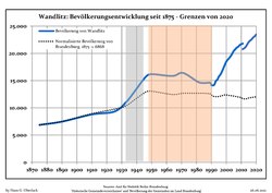 Development of Population since 1875 within the current Boundaries (Blue Line: Population; Dotted Line: Comparison to Population Development of Brandenburg state; Grey Background: Time of Nazi rule; Red Background: Time of Communist rule)
 -
 Recent Population Development and Projections (Population Development before Census 2011 (blue line); Recent Population Development according to the Census in Germany in 2011 (blue bordered line); Official projections for 2005-2030 (yellow line); for 2014-2030 (red line); for 2017-2030 (scarlet line)


|
|
|
Sightseeing
- Wandlitzsee lake
- The nearby lake of Liepnitzsee
- The Agricultural Museum in Wandlitz-old village (Barnim Panorama)
- The Steam Railway Museum in Basdorf (Heidekrautbahn-Museum)
- The International Museum of Circus Performers in Klosterfelde (Internationales Artistenmuseum)
- Several old churches
- Beautiful lakes in the surrounding area such as
- In the woods North East of the village Wandlitz is the small Bogensee with a former summer house of Joseph Goebbels, later part of the academy of the Free German Youth organization. Today the area belongs to the Berlin state forests and the buildings are to let.
Culture
- Goldener Löwe Kulturbühne: regular concerts, cabaret, opera, poetry readings, and comedy events.
- Studio of stained glass artist Annelie Grund
- Studio of Biomech tattoo Artist Markus Lenhard also known as Lux Altera
Sport & Leisure
- Windsurfing school and board hire on Wandlitzsee lake
- public beach and bathing area on Wandlitzsee
- Horse-riding
- 27-hole golf-course at nearby Prenden
Twin towns
 La Ferrière, Vendée, France
 Trzebiatów, Poland
 Gladbeck, North Rhine-Westphalia
 Schwechat, Austria
 London Borough of Enfield, Great Britain
 Alanya, Turkey
 Fushun, China
History
Wandlitz was first mentioned as
From 1815 to 1945, Wandlitz was part of the Prussian Province of Brandenburg, from 1945 to 1952 of the State of Brandenburg, from 1952 to 1990 of the East German Bezirk Frankfurt and since 1990 again of Brandenburg.
- Development

The name Wandlitz was and is also often used as a synonym for the nearby "
Shortly after World War II, the village was home to an orphanage of children from Berlin. The orphanage, run by nuns, later became a holiday spot for visiting high-ranking Communist party members. The children of the small orphanage were frowned upon as second-class citizens by villagers, and often went hungry.
Pictures from Towns and Villages in Gemeinde Wandlitz
-
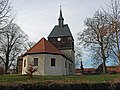 Village church of old Wandlitz
 -
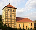
 Catholic church in the new quarter Wandlitzsee (Lake of Wandlitz)
 -
 Village church on Basdorf village green
 -
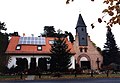
 Old village cottage in Schönwalde
 -
 Lanke Palace
 -
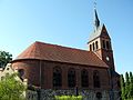
 Village church of Schönerlinde
 -
 Village church of Klosterfelde
 -
 Village church of Stolzenhagen
 -
 Village church of Prenden
 -
 Church in Lanke
 -
 Obersee in Lanke
 -
 Information on twin towns


.jpg)


Transport
Wandlitz is situated at the junction of the
References
- ^ Landkreis Barnim Wahl der Bürgermeisterin / des Bürgermeisters, accessed 30 June 2021.
- Amt für Statistik Berlin-Brandenburg(in German). June 2023.
- ^ Detailed data sources are to be found in the Wikimedia Commons.Population Projection Brandenburg at Wikimedia Commons
External links
- Heidekrautmuseum Basdorf
- Internationales Artisetenmuseum Klosterfelde
- Agrarmuseum Wandlitz
- Goldener Löwe
- Niederbarnimer Eisenbahn - NEB Heidekrautbahn railway
- Prenden Golf Course
Towns and municipalities in Barnim district | ||
|---|---|---|
 | ||
| International | |
|---|---|
| National | |
| Geographic | |