
Bernau bei Berlin
Bernau bei Berlin | |
|---|---|
.jpg) Town hall | |
 Coat of arms | |
Location of Bernau bei Berlin within Barnim district  | |
Ortsteile | |
| Government | |
| • Mayor (2022–30) | André Stahl[1] (Left) |
| Area | |
| • Total | 103.73 km2 (40.05 sq mi) |
| Elevation | 68 m (223 ft) |
| Population (2022-12-31)[2] | |
| • Total | 43,685 |
| • Density | 420/km2 (1,100/sq mi) |
| Time zone | UTC+01:00 (CET) |
| • Summer (DST) | UTC+02:00 (CEST) |
| Postal codes | 16321 |
| Dialling codes | 03338 |
| Vehicle registration | BAR, BER, EW |
| Website | www.bernau-bei-berlin.de |
Bernau bei Berlin (English Bernau by Berlin, commonly named Bernau) is a town in the Barnim district in Brandenburg in eastern Germany, located about 10 km (6.2 mi) northeast of Berlin.
History
Archaeological excavations of
Bernau underwent an

From the 18th century, Bernau was part of the Kingdom of Prussia, and from 1815 to 1947, it was administratively located in the Province of Brandenburg.
During World War II, in 1943–1945, it was the location of a subcamp of the Sachsenhausen concentration camp.[3] In early 1945, a death march of prisoners of various nationalities from the dissolved camp in Żabikowo to Sachsenhausen passed through the town.[4]
From 1947 to 1952 it was part of the State of


Demography
-
 Development of Population since 1875 within the Current Boundaries (Blue Line: Population; Dotted Line: Comparison to Population Development of Brandenburg state; Grey Background: Time of Nazi rule; Red Background: Time of Communist rule)
 -
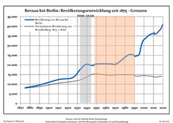
 Recent Population Development and Projections (Population Development before Census 2011 (blue line); Recent Population Development according to the Census in Germany in 2011 (blue bordered line); Official projections for 2005-2030 (yellow line); for 2014-2030 (red line); for 2017-2030 (scarlet line)


|
|
|
Local Divisions
The Town has the following local divisions:
- Birkenhöhe (since 2014)
- Birkholz (incorporated in 1993, district since 2014)
- Birkholzaue (since 2014)
- Börnicke (since 2002)
- Ladeburg (since 2001)
- Lobetal (since 2002)
- Schönow (since 2003)
- Waldfrieden (since 2016)
Several small local settlements are also part of the city:
- Bernau Süd
- Blumenhag
- Eichwerder
- Friedenstal
- Gieses Plan
- Helenenau
- Kirschgarten
- Liepnitz
- Lindow
- Neubauernsiedlung
- Nibelungen
- Puschkinviertel
- Rehberge
- Rollberg
- Rutenfeld
- Schmetzdorf
- Stadtkern
- Thaerfelde
- Viehtrift
- Waldsiedlung
- Woltersdorf
Main sights

Museums
The museum of local history has two locations. One is the
In 2005, the Wolf Kahlen Museum opened. Media art from over 40 years is shown there.
In 2005,

Buildings
The church of St. Marien in the Late Gothic style dominates the skyline of the town. The nave was built in the 15th century.
Large parts of the defensive walls and wet moats of the Middle Ages are preserved. The defensive wall is supplemented by several lookout houses, the Pulverturm (armoury) and a town gate.
Until the 1960s, the city centre, enclosed by the defensive wall, consisted of small old buildings with
The former ADGB school is located in the northeast of the town. It is the largest building in the Bauhaus style besides the Bauhaus itself.
- Breitscheidstraße
-

-

-

-

-
-
-


Transport
The line S2 of the Berlin S-Bahn (suburban railway) connects Bernau with Berlin Friedrichstraße's station, in the center of that city. Regional rail connects Bernau with Eberswalde, Schwedt, Stralsund, Frankfurt (Oder) to the north and Berlin Hauptbahnhof, Berlin Lichtenberg and Elsterwerda in the south. Long-distance trains go to Stralsund, Dortmund, Düsseldorf, Dresden and Amsterdam.
The
has the two exits Bernau Nord (number 15) and Bernau Süd (number 16).Twin towns – sister cities
Bernau bei Berlin is twinned with:[7]
 Champigny-sur-Marne, France
 Meckenheim, Germany
 Skwierzyna, Poland
Notable people
Honorary citizen
- Konrad Wolf (1925–1982), film director, President of the Academy of Arts, was the first city commander of Bernau after the Second World War (April 1945) at the age of 19, honorary citizen since 1975
Sons and daughters of the city
- Anton von Dejanicz-Gliszczynski (1820-1905), politician, member of German Reichstag
- Charlotte Mäder (born 1905), athlete.
- Hans-Jürgen Buchner(born 1944), musician and composer.
- Jeanette Biedermann (born 1980), entertainer.
People associated with Bernau
- Marianne Buggenhagen (born 1953), several times Paralympics winner, lives in Bernau.
- Wolf Kahlen (born 1940), performance, object and media artist, opened his museum in Bernau in 200.5
- Günther Maleuda (1931–2012), politician (DBD), President of the Volkskammer prior to German reunification .
- Hannes Meyer (1889–1954), architect, built the Bundesschule des Allgemeine Deutscher Gewerkschaftsbundes (ADGB Trade Union School) in Bernau from 1928 to 1930.
- Andreas Müller (born 1961), youth judge in Bernau.
- Johanna Olbrich (1926–2004), spy, lived out her final years in Bernau.
See also
References
- ^ Landkreis Barnim Wahl der Bürgermeisterin / des Bürgermeisters, accessed 10 November 2022.
- Amt für Statistik Berlin-Brandenburg(in German). June 2023.
- ISBN 978-0-253-35328-3.
- ^ "Ewakuacja piesza". Muzeum Martyrologiczne w Żabikowie (in Polish). Retrieved 8 November 2023.
- ^ UNESCO: Bauhaus and its Sites in Weimar, Dessau and Bernau. Retrieved 3 January 2019
- ^ Detailed data sources are to be found in the Wikimedia Commons.Population Projection Brandenburg at Wikimedia Commons
- ^ "Partnerstädte". bernau-bei-berlin.de (in German). Bernau bei Berlin. Archived from the original on 2019-09-01. Retrieved 2021-02-08.
External links
 Media related to Bernau bei Berlin at Wikimedia Commons
- Official website
 (in German)
Towns and municipalities in Barnim district | ||
|---|---|---|
 | ||
| International | |
|---|---|
| National | |
| Geographic | |