
Point Reyes


Point Reyes (
Overview
The cape protects
Point Reyes lends its name to the town of Point Reyes Station.
The point may once have been known as Lobes Lighthouse by the sailors of clipper ships on the meat trade.[3] (Lobes are ridges of slide material commonly referred to in the literature from erosion events and the point is of that shape out to sea.)
History

The Coast Miwok
The contemporary inhabitants of the Point Reyes area at the time of European arrival were the Coast
Although the Coast Miwok periodically interacted with European explorers,
In 1992, Coast Miwok descendants established the Federated Indians of Graton Rancheria, and in December 2000, legislation passed granting the tribe federal recognition. The tribe has almost 500 members,[4] who engage in a revival of traditional customs and ceremonies, often held in Kule Loklo, "Valley of the Bear", a replica Miwok village in Point Reyes National Seashore.[6]
Early Spanish exploration

On November 13, 1542, Spanish explorer Juan Rodríguez Cabrillo sighted and named "Cabo de Pinos" (Point Reyes), but missed the entrance to San Francisco Bay, a lapse that mariners would repeat for the next two centuries and more, due to the fog that characterizes the area. The Spanish explorer Sebastián Vizcaíno named the land Punto de los Reyes ("Kings' Point") when his ship, the Capitana, anchored in Drakes Bay on the Day of the Three Kings (Epiphany, or the end of the 12 Days of Christmas) on January 6, 1603.[7]
Sir Francis Drake

Although early explorers and Spanish trading galleons journeying between the Philippines and Acapulco passed by Point Reyes, some even anchoring briefly, it is the landing by Sir
The wreck of San Agustin


Rumors of Drake's discovery of a safe harbor on the California coast intrigued the Spanish. Their trade between the Philippines and Mexico was booming, and they were constantly seeking safe harbors along their route. Many believe that Drake's discovery of such a harbor inspired the Spanish to order
Struggling with a decrepit, heavily laden ship and a tired crew, Cermeno explored the California coast, eventually anchoring near the Point Reyes inlet now called Drakes Estero. Within a few days, a November storm beached the ship where it listed and was relentlessly pounded by the furious surf. It soon broke apart, killing several men and dumping the precious cargo, some of which was eventually collected and used by the local Coast Miwok inhabitants.[9]
Cermeno salvaged a small, open launch, likened to a large canoe, and loaded it with the 70 surviving crew members to begin the long journey home. After a grueling two-month voyage, remembered as a remarkable feat of seamanship, Cermeno and all crew arrived safely in Acapulco in January 1596. Despite his amazing journey, Cermeno received no celebratory welcome, for he had not only lost his ship and cargo, but had also failed to locate the safe harbor he was ordered to find.[9]
Portolá's inland expedition and the establishment of missions
Despite reports of a lovely land populated by friendly tribes, Spain neglected California until the second half of the 18th century. By that time, trade had become an important source of income, and it was becoming clear that the nation controlling California's harbors would reap incredible profits. When England, France, and Russia began to covet California's coast, the King of Spain knew it was time to fortify it. To identify sites for presidios and missions, an overland expedition of 67 men and 100 pack mules left San Diego in 1769. Led by
Beginning with Portolá's expedition, Spain began establishing presidios and missions. By 1817,
Mexico gained independence from Spain and possession of California in 1821. Most mission land was subdivided and into large land grants used mainly for cattle ranching. Being mostly unsuitable for cattle, Point Reyes itself and Drake's Bay became part of Rancho Punta de los Reyes Sobrante (Sobrante means "leftover") in 1843.[12] This was only a few years before cession of California to the United States, which led to decades of confusion and boundary battles.[9]
Rancho Tomales y Baulines
When the Spanish missions in California were dismantled, virtually all of Point Reyes was given to 'Rafael Garcia, a corporal in the Mexican Army, who was awarded two leagues (8,911 acres (3,606 ha)) in March 1836. Named Rancho Tomales y Baulines, it is believed to have included the entire Olema Valley from Tomales Bay to Bolinas Lagoon, although its borders were never clearly defined. Garcia's failure to survey and confirm boundaries, as required by Mexican law, set the stage for confusion and lengthy court battles when the rancho was dissolved.
Unlike many rancheros, Garcia obeyed the law by actually living there. He built a wood and thatch home near what is now the National Seashore's Bear Valley Headquarters and soon had a home for his family as well as a headquarters for his extensive ranching operation which consisted of approximately 3,000 cattle, 400 horses, and large herds of sheep and hogs.[citation needed]
When Mexico lost California to the United States, Garcia continued to prosper. Soon after the American takeover, the 1849 Gold Rush brought floods of prospectors. Where his wild cattle had been valued only for hides and tallow, he could now sell them to feed hungry gold-seekers, netting as much as $35 each. Unfortunately for Garcia, these gold-rich years ended quickly: in 1851, the United States passed a law requiring rancheros to prove legal ownership of their land grants. While the Garcias continued ranching, their land began to disappear until, after 15 years of litigation, multiple court appearances, and high legal fees, Garcia had sold all but 3,085 acres (1,248 ha) of his grant at bargain prices.[9]
Confused boundaries
Although Garcia believed he owned virtually all of Point Reyes, another Point Reyes land grant was awarded the same year, 1836. It was given to an Irishman, James Berry, who had become a Mexican citizen and colonel in the army. This land grant was also in the Olema Valley, and, to add to the boundary confusion, he soon left the area and hired Garcia to oversee it. A mere two years later, Berry sold nearly 9,000 acres (3,642 ha) of it to a sea captain, Joseph Snook, an act clearly prohibited by Mexican law and grounds for forfeiture of the entire grant. Although Berry understandably wanted to keep the sale secret, Snook wanted legal title. He discovered that the only way he could obtain legal title of the land he had illegally purchased was to formally denounce Berry's ownership on the grounds that he had never occupied it. He was successful and gained legal title to the land he had illegally purchased, stocked it with 56 head of cattle, and, like Berry, hired Garcia to oversee it. Three months after he won legal title, he illegally sold it.
And so began a confusing series of sales and transfers that no one seemed to be able to untangle. Finally, in 1844, the rancheros themselves asked the Mexican government to investigate titles and clarify ownership. Little was clarified, and it was not until the United States took possession of California and required rancheros to conduct surveys and make court appearances to retain their land that the confusing pattern of sales and trades were untangled. Most rancheros were eventually able to prove ownership. Unfortunately, by this time, they had run out of cash and were forced to sell to pay the survey and daunting legal fees. Entrepreneurial Americans were delighted to capitalize on the opportunity. With cash in hand, they purchased these huge Mexican land grants, often paying less than $2 per acre, thus beginning Point Reyes's next chapter as a dairying empire.[9]
The Shafter Family
Settlement patterns at Point Reyes were forever changed when the Shafters acquired it. Brothers Oscar Lovell Shafter and James McMillan Shafter established large-scale successful dairy operations.[citation needed] 13 of the 31 dairies they established still operate today.
Oscar was the first to arrive. A Vermont lawyer intent upon making his fortune and returning home as soon as possible, he left his family to journey to booming San Francisco. His separation from them became intolerable when his two youngest children died while he was away. Still not willing to give up the promise of wealth, he convinced his wife to come, bringing their surviving daughter. They thrived, and Oscar fathered four more California-born daughters. Oscar soon convinced his younger brother, James, also a lawyer, to join him. They became known as San Francisco's foremost authorities on title litigation. Using their title expertise, they began acquiring Point Reyes land. When Oscar's oldest daughter married Charles Webb Howard, also a lawyer, the trio partnered to transform windswept Point Reyes into prosperous dairies.
Determined to supply booming San Francisco with its butter, by 1857, the partners began fencing significant expanses of land (eventually resulting in 40 miles of fencing), building homes and barns, and stocking the dairies with the pure-bred bulls and rams, some costing over $1,400. By 1868, they had 3,500 cows on 17 dairies and were producing over 700,000 pounds of butter a year. All their dairies were operated by renters. When the most industrious of these renters tried to buy the dairy they worked, they failed. Many eventually left, establishing some of California's other major dairies.
Despite their boundless optimism about the promise of Point Reyes, they were plagued by financial worries. After they passed, their children tried to hold on to the dairies, trying unsuccessfully to stop their decline despite aging ranches, sickening herds, and often unhappy tenants. Finally, in 1937, an era ended when the last of the Shafter Empire was sold, ushering in a new parade of owners.[9]
The towns of Point Reyes
Four towns can be found on Point Reyes:

As soon as the Shafter dairies began to thrive, it became evident that Point Reyes needed a centrally located town for supplies, services, and entertainment. In 1857, a hotel and saloon were built and the young town was named "Olema", meaning "coyote" in the Coast Miwok dialect.[citation needed] Within three years, it had emerged as the region's commercial center with a post office, grocery store, saloon, butcher, livery stable, and two hotels. By 1867, a wagon road from San Rafael was built and a stage coach arrived twice a week. Druids Hall was completed in 1885.[13] While this Olema chapter of the United Ancient Order of Druids adhered to principles of mutual support, intellectual growth, and social consciousness, it also served as a temperance society.
The Shafters lobbied hard for a railroad to serve Point Reyes. When it was finally built, it bypassed Olema, terminating, instead, two miles away. When the first train arrived early in 1875, Point Reyes Station was a cow pasture. By 1880, it had a hotel, saloon, blacksmith shop, livery stable, butcher shop, and school. Its post office was completed in 1882, and its first store opened in 1883. When the railroad era ended, growth was slow. It was not until after World War II that a medical center and a shopping center, including a drugstore, dentist, coffee shop, and library, had been completed. The train station became the local post office, while the former engine house was converted into a community center. In the 1970s, hippies established cottage industries in abandoned houses and shops. At the same time, the Coast Guard bought 30 acres of land formerly used as cattle pens, and built military housing. Continuing as the region's supply and service center, it is a popular destination with shops, restaurants, and an annual music festival.[9][14]
20th century
As developers and loggers submitted plans, a 1956 National Park Service (NPS) study of possible seashore parks recommended acquisition of the peninsula. By 1958, a report was published recommending immediate NPS acquisition of 35,000 acres. Controversy raged, with environmentalists applauding the proposal and the ranchers opposing it. A compromise was crafted which allowed the ranchers to lease their land and continue dairying while coexisting with tourists and park activities. On September 13, 1962, President John F. Kennedy signed the bill authorizing the acquisition of 53,000 acres and allocating $13 million. Eventually 18,000 acres purchased by the NPS were leased back to ranchers.[15]
In cooperation with the NPS, volunteers have restored and maintain a historic coastal
During the Cold War, submarines repaired at Mare Island Naval Shipyard were tested in the shallow waters off Point Reyes following shipyard repairs. Navy safety personnel used a small monitoring and communications hut on the peninsula for monitoring submarines during these sea trials.
In April and May 1979, part of John Carpenter's The Fog was shot at the Point Reyes Lighthouse and the small town of Inverness.
As of 2015, Drakes Bay Oyster Company (DBOC) has ceased operations, and most infrastructure has been removed from the site. The closure comes as a result of their lease ending.
Ecology


Beginning in the 18th century,
California's native tule elk (Cervus canadensis nannodes) were hunted until only a handful of animals remained in California's southern Central Valley. Joseph Warren Revere, the grandson of Revolutionary War patriot Paul Revere, wrote in his book Naval Duty in California that he counted 400 elk in a single herd on Pt. Reyes in the 1840's.[21] Stephen J. Richardson, son of Marin County pioneer Captain William A. Richardson, wrote "I think the largest herd in the world roamed over the deep grasslands of Point Reyes...I fully believe there were a thousand elk in one herd."[22] Although they had been completely extirpated from Point Reyes, in 1978, ten elk were reintroduced to Point Reyes from the San Luis National Wildlife Refuge near Los Banos. By 2009, the population climbed to over 440 elk at Tomales Point's 2,600 acres of coastal scrub and grasslands. In 1999, 100 elk from Tomales Point were moved to the Limantour wilderness area of the Seashore and above Drakes Beach to Ranch A, as that ranch's long-term lease expired and was not renewed.[23] The drought in 2012–2015 was also a threat to the elk confined north of the fence on Tomales Point, with nearly half the elk there dying from lack of water. In 2012 there were 540 elk, then only 357 in 2013, and by 2014 only 286.[24] In August and September 2020, drought and wildfires again threaten the Tomales Point elk, leading some conservationists to illegally bring water to the elk north of the fence.[25] Half of the ten Point Reyes dairy cattle herds were infected with paratuberculosis (aka Johne's Disease) along with exotic deer in a 1977 study.[26] Tule elk became infected within two years of their reintroduction to the peninsula with this disease, which was brought to North America with Eurasian cattle.[27][28] Another nonnative, bacterial disease, brucellosis, can induce abortions in pregnant cattle, elk, and bison, and was also brought to North America by importation of Eurasian cattle. Pt. Reyes cattle have also infected the tule elk population.[29]
Non-native
Vegetation native to Point Reyes includes
Geology

The entire Point Reyes Peninsula is a piece of the Salinian Block transported northward by the San Andreas Fault. Its core is granite, unlike the terrain east of Tomales Bay. The granite rocks that form the peninsula were once continuous with the Tehachapi Mountains, which is located 350 mi (563 km) south of here. In the 1906 earthquake, Point Reyes moved north 21 ft (6.4 m).[32]
Point Reyes is bounded to the east by the
Climate
The
| Climate data for Point Reyes (1914–1943; temperatures 1917–1926) | |||||||||||||
|---|---|---|---|---|---|---|---|---|---|---|---|---|---|
| Month | Jan | Feb | Mar | Apr | May | Jun | Jul | Aug | Sep | Oct | Nov | Dec | Year |
| Record high °F (°C) | 78 (26) |
75 (24) |
76 (24) |
81 (27) |
80 (27) |
84 (29) |
75 (24) |
72 (22) |
88 (31) |
90 (32) |
79 (26) |
70 (21) |
90 (32) |
| Mean daily maximum °F (°C) | 54.2 (12.3) |
54.1 (12.3) |
53.8 (12.1) |
54.5 (12.5) |
54.4 (12.4) |
56.7 (13.7) |
57.6 (14.2) |
57.9 (14.4) |
61.0 (16.1) |
61.0 (16.1) |
59.4 (15.2) |
55.4 (13.0) |
56.7 (13.7) |
| Mean daily minimum °F (°C) | 45.1 (7.3) |
45.9 (7.7) |
45.4 (7.4) |
46.3 (7.9) |
46.7 (8.2) |
48.3 (9.1) |
49.4 (9.7) |
50.4 (10.2) |
51.2 (10.7) |
50.7 (10.4) |
49.9 (9.9) |
46.8 (8.2) |
48.0 (8.9) |
| Record low °F (°C) | 31 (−1) |
38 (3) |
35 (2) |
39 (4) |
40 (4) |
40 (4) |
47 (8) |
45 (7) |
47 (8) |
47 (8) |
43 (6) |
34 (1) |
31 (−1) |
| Average precipitation inches (mm) | 3.41 (87) |
3.05 (77) |
1.94 (49) |
1.23 (31) |
0.66 (17) |
0.25 (6.4) |
0.04 (1.0) |
0.03 (0.76) |
0.36 (9.1) |
1.03 (26) |
1.73 (44) |
3.32 (84) |
17.05 (432.26) |
| Source: Western Regional Climate Center [37] | |||||||||||||

Fog
It can get very foggy and windy during certain parts of the year at the lighthouse, and to be effective, the lighthouse had to be situated below the characteristic high fog. When foggy, visibility is so slim that one cannot even view the lighthouse from the top of the approximately 300 steps necessary to walk down to reach it.[38]
The lighthouse serves a great purpose in such a foggy area, as there is no beach to wash up on; it is on a rocky cliff. Day or night, the light may be the only thing visible to ships.[38]
Recreation
The peninsula is a popular recreational destination for the nearby
-
 Stairway to Point Reyes Lighthouse
 -
 Point Reyes Lighthouse in fog
 -
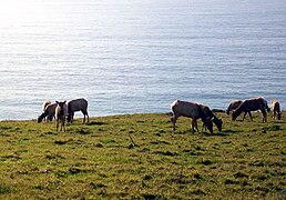 Tule elk grazing by the seaside
 -
 An elephant seal on the beach
 -
 Point Reyes on a foggy day
 -
 Point Reyes seashore
 -
 Coastline as seen from Chimney Rock


References
- ISSN 0261-3077. Retrieved September 28, 2023.
- ^ Johnson, Trisha (September 18, 2020). "Woodward Fire". ArcGIS StoryMaps. Retrieved September 28, 2023.
- ^ Japan, Pitcairn, San Francisco Farallon Islands, above the Fog Bank, (c. 1891) Alan Bruce Harper and friend Mr. F.W. Wilsden (Liverpool apprentices) Logs "picking up a pilot"
- ^ a b "Coast Miwok at Point Reyes". National Park Service.
- ^ a b "Early European Explorers at Point Reyes". Point Reyes National Seashore.
- ^ "Kule Loklo Coast Miwok Cultural Exhibit". Point Reyes National Seashore Association.
- ^ "Point Reyes, CA". Lighthouse Friends.
- ^ The Drake's Cove site began its review by the National Park Service (NPS) in 1994 [1], thus starting an 18-year study of the suggested Drake sites. The first formal Nomination to mark the Nova Albion site at Drake's Cove as a National Historic Landmark was provided to NPS on January 1, 1996. As part of its review, NPS obtained independent, confidential comments from professional historians. The NPS staff concluded that the Drake's Cove site is the "most probable" [2] and "most likely" [3] Drake landing site. The National Park System Advisory Board Landmarks Committee sought public comments on the Port of Nova Albion Historic and Archaeological District Nomination [4] and received more than two dozen letters of support and none in opposition. At the Committee's meeting of November 9, 2011 in Washington, DC, representatives of the government of Spain, the National Oceanic and Atmospheric Administration and Congresswoman Lynn Wolsey all spoke in favor of the nomination: there was no opposition. Staff and the Drake Navigators Guild's president, Edward Von der Porten, gave the presentation. The Nomination was strongly endorsed by Committee Member Dr. James M. Allan, Archeologist, and the Committee as a whole which approved the nomination unanimously. The National Park System Advisory Board sought further public comments on the Nomination [5]: no additional comments were received. At the Board's meeting on December 1, 2011 in Florida, the Nomination was further reviewed: the Board approved the nomination unanimously. On October 16, 2012, Secretary of the Interior Ken Salazar signed the nomination, and on October 17, 2012, The Drakes Bay Historic and Archaeological District was formally announced as a new National Historic Landmark.[6]
- ^ a b c d e f g h Baker, Gayle (2011). Point Reyes, A HarborTown History. HarborTown Histories.
- ISBN 978-0-679-74072-8.
- ^ Bolton, Herbert E. (1927). Fray Juan Crespi: Missionary Explorer on the Pacific Coast, 1769–1774. HathiTrust Digital Library. pp. 226–227.
- ^ Marin County rancho map Archived 2016-05-03 at the Wayback Machine
- ^ "Druids in Marin County | Marin County Free Library". Retrieved July 7, 2020.
- ^ Paul Liberatore (July 15, 2010). "Far-out music at this year's Far West Fest". eToday. Retrieved April 13, 2012.
- ^ Baker, Gayle, p. 97–102.
- ^ Maritime Radio Historical Society of America
- ^ . Retrieved November 11, 2021.
- ISBN 978-1-59714-061-4. Retrieved September 5, 2011.
- ISBN 978-0-7735-0610-7. Retrieved September 5, 2011.
- ^ "Elephant Seals". National Park Service. Retrieved September 5, 2011.
- ^ Joseph Warren Revere (1947). Naval Duty in California. Oakland, California: Biobooks. p. 245.
- ^ Stephen J. Richardson (1918). James Hepburn Wilkins (ed.). Days of the Dons: Reminiscences of California's Oldest Native Son. San Francisco Bulletin.
- ^ "Tule Elk". National Park Service. Retrieved September 5, 2011.
- ^ "Drought Likely Cause of Death for 250 Native Elk At Point Reyes National Seashore". AP Press. April 16, 2015. Retrieved September 2, 2020.
- ^ Deborah Moskowitz. "Drought and Wildfire Threaten Tule Elk at Point Reyes National Seashore". Western Watersheds Project. Retrieved September 2, 2020.
- PMID 500426.
- PMID 7328012.
- S2CID 36109118. Retrieved October 30, 2021.
- ^ Alison Hawkes (February 28, 2016). "Point Reyes Elk Test Positive for Disease. Are cattle to blame?". Bay Nature. Retrieved October 30, 2021.
- ^ "Non-Native Deer". Point Reyes National Seashore. National Park Service. Retrieved December 23, 2013.
- ^ Ted Williams (March 23, 2016). "Recovery: Mending Point Reyes, a Park Impaired by Invasive Mammals". Cool Green Science. Retrieved September 2, 2020.
- ISBN 978-0-679-44678-1.
- ^ Galloway, A. J, 1977, Geology of the Point Reyes Peninsula, Marin County, California: California division of mines and geology bulletin, v. 202.
- .
- ^ Woodley, S. R. and K. Grove, 2010, INTERPRETING PLEISTOCENE MARINE TERRACE DEPOSITS OVERLYING THE 82 Ka WAVE-CUT PLATFORM, POINT REYES PENINSULA, MARIN COUNTY, CALIFORNIA, San Francisco State Univ, Paper No. 18-26, Cordilleran Section – 106th Annual Meeting, and Pacific Section, American Association of Petroleum Geologists, 27–29 May 2010.
- ^ Central California
- ^ "WRCC". Retrieved June 19, 2015.
- ^ a b "Lighthouse History at Point Reyes". National Park Service. Retrieved April 13, 2012.
- ^ "Trail Guide & Suggested Hikes - Point Reyes National Seashore (U.S. National Park Service)".
External links
- Point Reyes National Seashore, National Park Service