
Severnaya Zemlya
Severnaya Zemlya
Северная Земля | |
|---|---|
UTC+7 |
Severnaya Zemlya (Russian: Сéверная Земля́, lit. 'Northern Land', pronounced [ˈsʲevʲɪrnəjə zʲɪmˈlʲa]) is a 37,000 km2 (14,000 sq mi) archipelago in the Russian high Arctic. It lies off Siberia's Taymyr Peninsula, separated from the mainland by the Vilkitsky Strait. This archipelago separates two marginal seas of the Arctic Ocean, the Kara Sea in the west and the Laptev Sea in the east.
Severnaya Zemlya was first noted in 1913 and first charted in 1930–32, making it the last sizeable archipelago on Earth to be explored.[1] Administratively, the islands form part of Russia's Krasnoyarsk Krai. In Soviet times there were a number of research stations in different locations, but currently there are no human inhabitants in Severnaya Zemlya, except for the Prima Polar Station[2] near Cape Baranov.[3]
The largest glacier in the Russian Federation, the Academy of Sciences Glacier, is located in Severnaya Zemlya. Until recently, ice joined the islands to Eurasia, even at its smallest extent during the late summer melt season, blocking the Northeast Passage between the Atlantic and the Pacific. By the late summer of 2012, however, due to Arctic sea ice decline the permanent ice had reached a record low extent and open water appeared to the south of the archipelago.[4]
History
Although Severnaya Zemlya lies not far off the northern coast of Siberia, cartographers did not formally record it until the 20th century. Earlier explorers deemed that there was a land mass in the general area - note for example the report by
Later in the 19th century,
Even at the end of the 19th century, both
-
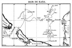 Map of the Kara Sea drift of steamship Dijmphna in 1882–83. This venture would have discovered the land now known as Severnaya Zemlya had it been successful.
 -
 c. 1902 map section of the Yeniseysk Governorate with empty ocean in the location of the archipelago


Emperor Nicholas II Land
The archipelago first appeared on the map with the 1913–1915 Arctic Ocean Hydrographic Expedition of the
On 3 September 1913 (22 August 1913 in the
-
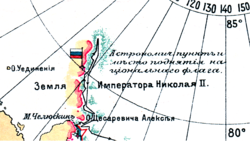 Section of the 1913 Arctic Ocean Hydrographic Expedition map showing incompletely charted Emperor Nicholas II Land —with an undefined western coast. The Russian flag stands on the Cape Berg area.
 -
 Partly surveyed Emperor Nicholas II Land in a 1915 map of the Russian Empire. At the time it was believed that the archipelago formed a single landmass.
 -
 Russian 2013 stamp set featuring Boris Vilkitsky, his ships and the landscape of the area - dedicated to the 100th anniversary of the discovery of Severnaya Zemlya.


Later exploration and present era
In 1926, the
In the spring of 1931,
I have seen God-forsaken
Chukotka Peninsula, blizzard-ridden Wrangel Island, twice visited fog-enshrouded Novaya Zemlya, and I have seen Franz Josef Land with its enamel sky and proud cliffs garbed in blue, hardened glacial streams, but nowhere did I witness such grimness or such depressing, lifeless relief...[16]
The Graf Zeppelin flew over the area during its polar flight of July 1931 and recorded some cartographic and meteorological data; Hugo Eckener tried to take pictures of the yet unsurveyed western coast, but it was obscured by fog and clouds.[17]
Although
During the period of the
Administratively, Severnaya Zemlya formed part of the Taymyr Autonomous Okrug until this okrug was merged into Krasnoyarsk Krai on 1 January 2007. As of 2021[update] it belongs to the Taymyrsky Dolgano-Nenetsky District of Krasnoyarsk Krai. There has been a request at the Krasnoyarsk Krai Legislative Assembly to reinstate the former name of Severnaya Zemlya as "Emperor Nicholas II Land" (Russian: Земля Николая II). This request, however, has been rejected by the local government for the time being.[12]
-
 View of the remains of abandoned Izluchina Russian polar station at the northern end of Komsomolets Island
 -
 1975 map showing Severnaya Zemlya and the Taymyr Peninsula
 -
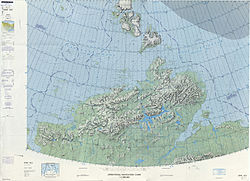
 MODISimage of Severnaya Zemlya in 2001


Geography

Severnaya Zemlya comprises four major islands – October Revolution, Bolshevik, Komsomolets, and Pioneer – and around 70 smaller islands, covering a total area of about 37,000 km2 (14,300 sq mi). It is separated from the Taymyr Peninsula by the Vilkitsky Strait.[22] Komsomolets is separated from Canada's northernmost point, Cape Columbia, by under 2000km.
Four of the main islands are largely glaciated, October Revolution, Komsomolets, and Pioneer, as well as the smaller
This archipelago encloses the northern limits of the
Glaciers

Glaciers in the archipelago have a characteristic
October Revolution, with seven
Main islands
October Revolution

October Revolution Island (Russian: Остров Октябрьской Революции, Ostrov Oktyabrskoy Revolyutsii) is the largest island of the Severnaya Zemlya group in the Russian Arctic.
The area of this island has been estimated at 14,170 km2 (5,470 sq mi) making it the 59th largest island in the world.
October Revolution Island houses five domed ice caps; clockwise from north, they are named:
Ostrov Vysokiy is an islet located in a small bay on October Revolution Island's southwest shores.
Bolshevik

Bolshevik Island (Russian: о́стров Большеви́к, pronounced [ˈostrəv bəlʲʂɨˈvʲik]) is the southernmost and second largest island in the group, located across the Shokalsky Strait from October Revolution Island. The area of this island has been estimated at 11,312 km2 (4,370 sq mi).
Bolshevik Island is mountainous, reaching a height of 935 m (3,068 ft). It houses an
Parts of the shore of the island are deeply indented, with Mikoyan Bay in the north and Solnechny Bay in the south, as well as fjords such as the large Akhmatov Fjord, and the smaller Thaelmann Fjord, Spartak Fjord and Partizan Fjord.
Bolshevik Island is comparatively less glaciated than the other islands of Severnaya Zemlya. Only about 30% of the island is covered by glaciers while the coastal plains have a sparse vegetation of moss and lichen. The Leningrad Glacier, Semyonov-Tyan-Shansky Glacier, Kropotkin Glacier, Mushketov Glacier and Aerosyomki Glacier are located in the interior of the island and do not reach the sea.[36]
Ostrov Tash is a small island located on Bolshevik's southern shore. Lavrov Island is located off the NE shore and Ostrov Lishniy off its northern tip.
Komsomolets

Komsomolets Island (Russian: остров Комсомолец) is the northernmost island of the Severnaya Zemlya group in the Russian Arctic, and the third largest island in the group. It is the 82nd largest island on earth.
The northernmost point of the island is called the Arctic Cape. This is the launching point for many Arctic expeditions.
The area of this island has been estimated at 9,006 km2 (3,477 sq mi). It rises to a height of 780 m (2,559 ft). Some 65% of the island is covered with glaciers. Komsomolets Island is home to the largest ice cap in Russia, the
The soil of the island is mostly composed of loose
Off the northwestern shores of Komsomolets Island lies a group of islets known as Ostrova Dem'yana Bednogo.
Pioneer Island

Pioneer Island, Ostrov Pioner in Russian. It is the westernmost of the large islands of the Severnaya Zemlya group and is separated from Komsomolets Island by the Yuny Strait. Pioneer island measures 1,527 km2 (590 sq mi) in area.
This island houses the Pioneer Glacier.
Off Pioneer Island's southwestern end lies Krupskoy Island. This is a fairly large island, over 20 km (12 mi) in length and about 11 km (6.8 mi) in width. The sound that separates it from Pioneer is only 0.5 km (0.31 mi) in width.
This island should not be confused with Pioneer Island in Canada (76°57′N 96°57′W / 76.950°N 96.950°W).
Schmidt Island

Schmidt Island, measuring 467 km2 (180 sq mi), is located at the far northwestern end of the archipelago. This island is quite detached from the whole Severnaya Zemlya group. It is also its northernmost island and before modern climate warming it was fully in the region of permanent sea ice.
This island is almost entirely covered by the Schmidt Ice Cap. Owing to its exposed position, the climate in the Schmidt Island's area is much colder than in the rest of the archipelago.[30]
Schmidt Island was named after the Soviet scientist Otto Schmidt.
Minor islands and island groups
Close to the main archipelago of Severnaya Zemlya there are a number of smaller islands and archipelagos. There are also many small coastal islands and islets in different locations, such as Krupskoy to the west of Pioneer and Naydenysh (Russian: Найдёныш) near Cape Anuchin in October Revolution Island.[41] Among the other minor islands the following deserve mention:
Sedov Archipelago

The Sedov Archipelago, formerly known as Sergey Kamenev Islands,[42] is located just west of October Revolution Island on the Kara Sea side. The main islands of this archipelago are Sredny (the longest island), Domashnyy, Strela, and Figurnyy. Close to the shore of October Revolution Island lies Obmannyy Island and 32 km (20 mi) further offshore southwards lies Dlinnyy Island. These other coastal islands are sometimes included as part of the Sedov Group.
Golomyanniy Meteorological Station, located on the western tip of Sredniy Island at 79°33′N 90°38′E / 79.550°N 90.633°E,[43] was the wintering site and base of the 1931–32 expedition[15] and has been taking continuous measurements since 1954.[30]
An official request has been forwarded to rename Domashnyy Island as Svyatoy Anastasii (остров Святой Анастасии), St. Anastasia Island.[12]
Krasnoflotskiye Islands

Located just south of October Revolution Island in the Kara Sea. The Krasnoflotskiye Islands (Russian: Краснофлотские) extend from north to south in an almost straight line 78°36′N 98°40′E / 78.600°N 98.667°E. The main islands are Sverdlova – very close to Cape Sverdlov on the coast, Bolshoy – not much larger than the others despite its name, Sredniy and Greben far offshore. All islands are devoid of vegetation.
Two small islets named Opasnye, which are also part of this group, lie 35 km (19 nmi; 22 mi) to the southwest of Greben Island.
The Krasnoflotskiye Islands were first sighted and mapped in August 1932 by the expedition of the
Maly Taymyr and Starokadomsky

This is a small group including two main islands located in the Laptev Sea, off the far southeastern end of Bolshevik Island.
Maly Taymyr was discovered by Boris Vilkitsky during the Arctic Ocean Hydrographic Expedition in 1913 and was named "Tsarevich Alexei Island" (Russian: Остров Цесаревича Алексея),[7] after the son of Zar Nicholas II of Russia. Following the 1917 October Revolution the island was renamed "Maly Taymyr". In 2005 an official request was forwarded to the local government in Krasnoyarsk Krai in order to reinstate its former name to the island as Alexei Island.
Starokadomsky Island is close by to Maly Taymyr, located off its northwestern side and separated from it by a narrow six km-wide (3.7 mi) sound. This island was named after Dr. Leonid Starokadomsky, one of the leaders of the 1913 Arctic Ocean Hydrographic Expedition.
Lishniy Island

Lishniy Island (Russian: Лишний) is a coastal island located on the eastern side of the mouth of Akhmatov Fjord, southeast of Cape Unslicht, off Bolshevik Island's northern end at 79°11′N 103°24′E / 79.183°N 103.400°E. The island has an irregular shape and is 6 km (4 mi) long with a maximum width of 3.5 km (2.2 mi).
A deep round lake with a diameter of 700 m (2,300 ft) is located in the western part of the island and is connected to the sea by a small channel. Almost all the island is rocky, except for the northwestern part. The highest point of Lishniy Island is 27 m (89 ft)[45]
South of Lishniy lies Yuzhnyy, a smaller island, and two islets.
Climate
Severnaya Zemlya is consistently cold and quite dry (
| Climate data for Golomyanniy Meteorological Station | |||||||||||||
|---|---|---|---|---|---|---|---|---|---|---|---|---|---|
| Month | Jan | Feb | Mar | Apr | May | Jun | Jul | Aug | Sep | Oct | Nov | Dec | Year |
| Record high °C (°F) | 0.1 (32.2) |
−1.1 (30.0) |
0.4 (32.7) |
1.0 (33.8) |
3.2 (37.8) |
8.3 (46.9) |
13.3 (55.9) |
10.0 (50.0) |
5.8 (42.4) |
4.0 (39.2) |
0.8 (33.4) |
0.2 (32.4) |
13.3 (55.9) |
| Mean daily maximum °C (°F) | −23.5 (−10.3) |
−24.2 (−11.6) |
−23.3 (−9.9) |
−16.6 (2.1) |
−7.2 (19.0) |
−0.1 (31.8) |
1.9 (35.4) |
1.4 (34.5) |
−1.7 (28.9) |
−8.8 (16.2) |
−17.3 (0.9) |
−21.9 (−7.4) |
−11.8 (10.8) |
| Daily mean °C (°F) | −27.0 (−16.6) |
−27.7 (−17.9) |
−26.8 (−16.2) |
−19.9 (−3.8) |
−9.6 (14.7) |
−1.5 (29.3) |
0.7 (33.3) |
0.2 (32.4) |
−3.3 (26.1) |
−11.4 (11.5) |
−20.6 (−5.1) |
−25.3 (−13.5) |
−14.3 (6.2) |
| Mean daily minimum °C (°F) | −30.5 (−22.9) |
−31.1 (−24.0) |
−30.3 (−22.5) |
−23.1 (−9.6) |
−11.9 (10.6) |
−2.8 (27.0) |
−0.4 (31.3) |
−1.0 (30.2) |
−4.9 (23.2) |
−14.0 (6.8) |
−23.8 (−10.8) |
−28.6 (−19.5) |
−16.9 (1.6) |
| Record low °C (°F) | −48.4 (−55.1) |
−47.2 (−53.0) |
−50.7 (−59.3) |
−41.8 (−43.2) |
−29.6 (−21.3) |
−14.7 (5.5) |
−5 (23) |
−12 (10) |
−21.1 (−6.0) |
−35.7 (−32.3) |
−42.8 (−45.0) |
−48 (−54) |
−50.7 (−59.3) |
| Average precipitation mm (inches) | 11.1 (0.44) |
8.1 (0.32) |
8.7 (0.34) |
8.3 (0.33) |
7.7 (0.30) |
14.0 (0.55) |
23.2 (0.91) |
24.4 (0.96) |
22.1 (0.87) |
14.5 (0.57) |
10.0 (0.39) |
10.0 (0.39) |
162.1 (6.37) |
| Average precipitation days | 15 | 14 | 15 | 13 | 20 | 19 | 17 | 19 | 21 | 20 | 14 | 15 | 202 |
| Average rainy days | 0 | 0 | 0 | 0 | 1 | 0 | 0 | 10 | 9 | 4 | 0 | 0 | 22 |
| Average snowy days | 15 | 14 | 15 | 13 | 19 | 17 | 9 | 12 | 17 | 20 | 14 | 15 | 180 |
| Source 1: Météo climat stats (Averages and Extremes, Excluding July record high)[47] Roshydromet (July record high)[48] | |||||||||||||
| Source 2: Weather Reports (Average rainy and snowy days)[49] | |||||||||||||
Flora and fauna
Severnaya Zemlya is a
According to a survey of prior observations by De Korte, Volkov, and Gavrilo, thirty-two bird species have been observed on Severnaya Zemlya, 17 of which are known to breed on the islands. Eight species are widespread across the archipelago: five of which are colonial seabirds:
The most common mammal on Severnaya Zemlya is the collared lemming (Dicrostonyx torquatus), also known as Arctic lemming, which is present on all of the large islands and, in some places has been recorded to reach a density of 500 per km2 (1,300 per sq mi). The Arctic fox (Alopex lagopus) has been known to den on the islands, with several hundred observed in the 1980s. Other mammals occasionally observed include the wolf (Canis lupus), the polar bear (Ursus maritimus),[52] ermine (Mustela erminea), walrus (Odobenus rosmarus), Arctic hare (Lepus timidus), and reindeer (Rangifer tarandus).[51]
-
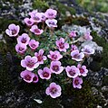 Purple saxifrage.
 -
 Severnaya Zemlya is the easternmost point in the little auk's breeding range.
 -
 Thick-billed murre (Uria lomvia).
 -
 Collared lemming (Dicrostonyx torquatus), the most common mammal on Severnaya Zemlya.


In culture
The discovery of Severnaya Zemlya is the subject of Veniamin Kaverin's novel The Two Captains as well as its stage adaptation, Nord-Ost.
The location of a secret Russian space weapons control facility is called Severnaya in the 1995 James Bond film GoldenEye. In several maps seen onscreen, however, this Severnaya is depicted as being in central Siberia. Severnaya is a level in GoldenEye 007, a 1997 video game based on the Bond film.
Severnaya is the site of a Kaiju-controlled rogue Jaeger (giant
Severnaya is the site of the final act of the 2021 movie The Tomorrow War, where the protagonists locate a crashed spaceship holding the dormant White Spike Aliens.
See also
- List of islands of Russia
- List of fjords of Russia
- List of glaciers of Russia
- List of research stations in the Arctic
- Great Northern Expedition
References
- ^ JSTOR 1796946.
- ^ "Фотогалерея: 2004 - "Полярное Кольцо" Местонахождение: 17 мая, Северная Земля, о. Большевик, м. Баранова, п/ст Примах". ec-arctic.ru.
- ProQuest 197714801.
- ^ Arctic Sea Ice Shrinks To New Low In Satellite Era Archived 20 May 2022 at the Wayback Machine Retrieved on 27 August 2012.
- ^ "The Danish-Arctic expedition proposed by A. Hovgaard, tr. by G. Zachariae". 5 June 1882 – via Internet Archive.
- ISBN 978-3-642-12401-3, p. 66
- ^ JSTOR 199861.
- hdl:10013/epic.29422. Archived from the original(PDF) on 16 October 2010.
- ^ "Mys Berga". Mapcarta. Retrieved 18 November 2016.
- ^ Oil of Russia : www.oilru.com : "Oil of Russia" magazine. www.oilru.com. Retrieved on 19 October 2010.
- ^ Архипелаг под псевдонимом Первооткрыватели Северной Земли дали ей совсем другое имя, которое, по-видимому, к ней не вернется (Archipelago under a pseudonym – Discoverers of the Northern Land gave it a completely different name which apparently did not return to it) —in Russian.
- ^ a b c "Депутаты Законодательного собрания Красноярского края против переименования островов архипелага "Северная Земля"". newslab.ru (in Russian). 27 May 2007. Retrieved 12 August 2015.
- ^ Umberto Nobile, With the Italia to the North Pole, p. 120.
- ^ "Архипелаг Северная Земля – Интернет-энциклопедии Красноярского края". krskstate.ru. Archived from the original on 24 November 2016. Retrieved 24 November 2016.
- ^ a b Николай, Урванцев. "Книга: Два года на северной земле". e-reading.club.
- ^ Brian Bonhomme, Russian Exploration, from Siberia to Space: A History, p. 157.
- ^ William J. Mills, Exploring Polar Frontiers: A Historical Encyclopedia, Volume 1, p. 204.
- ^ Kapustin, Igor V. "Архипелаг, открытый последним (Северная Земля) – Kapustin-Arctica Antarctica philatelia". ivki.ru.
- ^ "Исследование Северной Земли". amirov-marat.com.[permanent dead link]
- ^ "Бронтман Лазарь Константинович. Плавание на ледоколе "Садко" 1935 г." samlib.ru.
- ^ "Полярная Почта • Просмотр темы - Ушаков Г.А., По нехоженной земле". www.polarpost.ru.
- ^ a b GEO_099_121.pdf. (PDF) . Retrieved on 19 October 2010.
- ^ a b "Kapustin-Arctica Antarctica philatelia". archive.org. 31 July 2002. Archived from the original on 31 July 2002.
{{cite web}}: CS1 maint: bot: original URL status unknown (link) - ^ "Mys Neupokoyeva". Mapcarta. Retrieved 27 November 2016.
- ^ "Proliv Shokal'skogo". Mapcarta. Retrieved 23 November 2016.
- S2CID 129054785.
- ^ "Scholarly Resources for Learning and Research | Gale". www.gale.com.
- ^ "Октябрьской Революции Остров" Great Soviet Encyclopedia
- ^ ""Severnaya Zemlya" OceanDots.com". Archived from the original on 23 December 2010. Retrieved 23 December 2010.
{{cite web}}: CS1 maint: bot: original URL status unknown (link) - ^ S2CID 131042892. Archived from the originalon 3 March 2012. Retrieved 13 August 2015.
- ^ Männik, Peep; et al. (2002). "Silurian and Devonian strata Severnaya Zemlya and Sedov archipelagos (Russia)" (PDF). Geodiversitas. 24 (1): 99–122.
- ^ "Фиордовое in the State Water Register of Russia". verum.wiki (in Russian).
- ^ "Mys Oktyabr'skiy". Mapcarta. Retrieved 28 December 2016.
- ^ "Photo gallery". ec-arctic.ru.
- ^ New Russian polar station at Severnaya Zemlya
- ^ a b c "Arctic Ocean – Severnaya Zemlya". Archived from the original on 23 December 2010. Retrieved 23 December 2010.
{{cite web}}: CS1 maint: bot: original URL status unknown (link). Oceandots.com. Retrieved on 19 October 2010. - ^ "Ecoshelf". Archived from the original on 5 February 2012.
- ^ "Lednik Akademii Nauk". Mapcarta. Retrieved 24 December 2016.
- ^ "Russian Arctic – Severnaya Zemlya". Archived from the original on 23 December 2010. Retrieved 23 December 2010.
{{cite web}}: CS1 maint: bot: original URL status unknown (link) (which also features dramatic satellite photos of the islands of the Severnaya Zemlya group). - ^ Karatajūtē-Talimaa, Valentina; Märss, Tiiu (2002). "Upper Silurian thelodonts from Severnaya Zemlya Archipelago (Russia)". Geodiversitas. 24 (2): 405–443. INIST 13724455.
- ^ "Ostrov Naydënysh". Mapcarta. Retrieved 3 December 2016.
- S2CID 251049826– via Cambridge Core.
- ^ Gonçalves, Mário (7 February 2016). "Ultima Thule: Golomyanniy Station in Severnaya Zemlya- south of nowhere in Siberia's High Arctic, plus a... museum !". ultima0thule.blogspot.com.
- ^ TD13 Duplicate Stations List Archived 5 June 2009 at the Wayback Machine.
- ^ "Ostrov Lishniy". Mapcarta. Retrieved 3 December 2016.
- ^ "Топографическая карта Т-48-VII,VIII,IX. залив Ахматова". narod.ru.
- ^ "Moyennes 1981-2010 Russie (Asie)" (in French). Retrieved 1 November 2019.
- ^ "Climate of Golomyanniy" (in Russian). Weather and Climate (Погода и климат). Retrieved 1 November 2019.
- ^ "Weather Data for Golymyanniy Meteorological Station". Weather Reports. Retrieved 1 November 2019.
- ^ Manfred Bolter & Hiroshi Kanda (1997). "Preliminary results of botanical and microbiological investigations on Severnaya Zemlya 1995" (PDF). Proc. NIPR Symp. Polar Biol. 10: 169–178. Archived from the original (PDF) on 19 July 2011.
- ^ a b Bird Observations in Severnaya Zemlya, Siberia Archived 10 August 2022 at the Wayback Machine. (PDF). Retrieved on 19 October 2010.
- ^ "Polar Bears of the Severnaya Zemlya Archipelago of the Russian Arctic" (PDF). bearbiology.com. Retrieved 12 August 2018.
External links
 Media related to Severnaya Zemlya at Wikimedia Commons
- Oceandots – Severnaya Zemlya at the Wayback Machine (archived 23 December 2010)
- Arctic photos of Severnaya Zemlya by Ólafur Ingólfsson
- List of islands (Russian language)
- Glacial and Environmental History of Severnaya Zemlya, Siberian High Arctic, During the Last > 130,000 years Archived 8 June 2011 at the Wayback Machine
|
| International | |
|---|---|
| National | |