
Atlantic Branch
| Atlantic Branch | |||||||||||||||||||||||||||||||||||||||||||||||||||||||||||||||||||||||||||||||||||||||||||||||||||||||||||||||||||||||||||||||||||||||||||||||||||||||||||||||||||||||||||||||||||||||||||||||||||||||||||||||||||||||||||||||||||||||||||||||||||||||||||||||||||||||||||
|---|---|---|---|---|---|---|---|---|---|---|---|---|---|---|---|---|---|---|---|---|---|---|---|---|---|---|---|---|---|---|---|---|---|---|---|---|---|---|---|---|---|---|---|---|---|---|---|---|---|---|---|---|---|---|---|---|---|---|---|---|---|---|---|---|---|---|---|---|---|---|---|---|---|---|---|---|---|---|---|---|---|---|---|---|---|---|---|---|---|---|---|---|---|---|---|---|---|---|---|---|---|---|---|---|---|---|---|---|---|---|---|---|---|---|---|---|---|---|---|---|---|---|---|---|---|---|---|---|---|---|---|---|---|---|---|---|---|---|---|---|---|---|---|---|---|---|---|---|---|---|---|---|---|---|---|---|---|---|---|---|---|---|---|---|---|---|---|---|---|---|---|---|---|---|---|---|---|---|---|---|---|---|---|---|---|---|---|---|---|---|---|---|---|---|---|---|---|---|---|---|---|---|---|---|---|---|---|---|---|---|---|---|---|---|---|---|---|---|---|---|---|---|---|---|---|---|---|---|---|---|---|---|---|---|---|---|---|---|---|---|---|---|---|---|---|---|---|---|---|---|---|---|---|---|---|---|---|---|---|---|---|---|---|---|---|---|---|
 | |||||||||||||||||||||||||||||||||||||||||||||||||||||||||||||||||||||||||||||||||||||||||||||||||||||||||||||||||||||||||||||||||||||||||||||||||||||||||||||||||||||||||||||||||||||||||||||||||||||||||||||||||||||||||||||||||||||||||||||||||||||||||||||||||||||||||||
| Overview | |||||||||||||||||||||||||||||||||||||||||||||||||||||||||||||||||||||||||||||||||||||||||||||||||||||||||||||||||||||||||||||||||||||||||||||||||||||||||||||||||||||||||||||||||||||||||||||||||||||||||||||||||||||||||||||||||||||||||||||||||||||||||||||||||||||||||||
| Status | Operational | ||||||||||||||||||||||||||||||||||||||||||||||||||||||||||||||||||||||||||||||||||||||||||||||||||||||||||||||||||||||||||||||||||||||||||||||||||||||||||||||||||||||||||||||||||||||||||||||||||||||||||||||||||||||||||||||||||||||||||||||||||||||||||||||||||||||||||
| Owner | Long Island Rail Road | ||||||||||||||||||||||||||||||||||||||||||||||||||||||||||||||||||||||||||||||||||||||||||||||||||||||||||||||||||||||||||||||||||||||||||||||||||||||||||||||||||||||||||||||||||||||||||||||||||||||||||||||||||||||||||||||||||||||||||||||||||||||||||||||||||||||||||
| Locale | Western Long Island, New York, USA | ||||||||||||||||||||||||||||||||||||||||||||||||||||||||||||||||||||||||||||||||||||||||||||||||||||||||||||||||||||||||||||||||||||||||||||||||||||||||||||||||||||||||||||||||||||||||||||||||||||||||||||||||||||||||||||||||||||||||||||||||||||||||||||||||||||||||||
| Termini | |||||||||||||||||||||||||||||||||||||||||||||||||||||||||||||||||||||||||||||||||||||||||||||||||||||||||||||||||||||||||||||||||||||||||||||||||||||||||||||||||||||||||||||||||||||||||||||||||||||||||||||||||||||||||||||||||||||||||||||||||||||||||||||||||||||||||||
| Stations | 8 passenger, 1 employee-only | ||||||||||||||||||||||||||||||||||||||||||||||||||||||||||||||||||||||||||||||||||||||||||||||||||||||||||||||||||||||||||||||||||||||||||||||||||||||||||||||||||||||||||||||||||||||||||||||||||||||||||||||||||||||||||||||||||||||||||||||||||||||||||||||||||||||||||
| Service | |||||||||||||||||||||||||||||||||||||||||||||||||||||||||||||||||||||||||||||||||||||||||||||||||||||||||||||||||||||||||||||||||||||||||||||||||||||||||||||||||||||||||||||||||||||||||||||||||||||||||||||||||||||||||||||||||||||||||||||||||||||||||||||||||||||||||||
| Type | Commuter rail | ||||||||||||||||||||||||||||||||||||||||||||||||||||||||||||||||||||||||||||||||||||||||||||||||||||||||||||||||||||||||||||||||||||||||||||||||||||||||||||||||||||||||||||||||||||||||||||||||||||||||||||||||||||||||||||||||||||||||||||||||||||||||||||||||||||||||||
| System | Long Island Rail Road | ||||||||||||||||||||||||||||||||||||||||||||||||||||||||||||||||||||||||||||||||||||||||||||||||||||||||||||||||||||||||||||||||||||||||||||||||||||||||||||||||||||||||||||||||||||||||||||||||||||||||||||||||||||||||||||||||||||||||||||||||||||||||||||||||||||||||||
| Services | (Atlantic Shuttle)
(Peak Only)
standard gauge | ||||||||||||||||||||||||||||||||||||||||||||||||||||||||||||||||||||||||||||||||||||||||||||||||||||||||||||||||||||||||||||||||||||||||||||||||||||||||||||||||||||||||||||||||||||||||||||||||||||||||||||||||||||||||||||||||||||||||||||||||||||||||||||||||||||||||||
| Electrification | Third rail, 750 V DC | ||||||||||||||||||||||||||||||||||||||||||||||||||||||||||||||||||||||||||||||||||||||||||||||||||||||||||||||||||||||||||||||||||||||||||||||||||||||||||||||||||||||||||||||||||||||||||||||||||||||||||||||||||||||||||||||||||||||||||||||||||||||||||||||||||||||||||
| |||||||||||||||||||||||||||||||||||||||||||||||||||||||||||||||||||||||||||||||||||||||||||||||||||||||||||||||||||||||||||||||||||||||||||||||||||||||||||||||||||||||||||||||||||||||||||||||||||||||||||||||||||||||||||||||||||||||||||||||||||||||||||||||||||||||||||
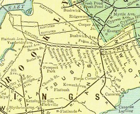
The Atlantic Branch is an
The line consists of two sections constructed separately. The portion of the line from Atlantic Terminal to Jamaica was constructed as part of the
Description
Partly underground and partly elevated, the Atlantic Branch runs from
The section between Atlantic Terminal and
At 121st Street in
History
The current Atlantic Branch is the successor to two separate lines: the
Atlantic Terminal to Jamaica
The
Initially the line turned halfway between Classon and Franklin Avenues, running halfway between Herkimer Street and Schuyler Street (now Atlantic Avenue) along the line of the present Herkimer Place. It turned slightly to the southeast near Howard Avenue, crossing the centerline of Schuyler Street about one-third of the way between Hopkinson Avenue (Thomas Boyland Street) and Paca Avenue (Rockaway Avenue). It crossed into the town of
The Atlantic Branch was one of the first lines in the LIRR system slated to be electrified. In anticipation of this the entire line to Jamaica was to be grade separated. Between 1903 and 1905 the line was depressed into a tunnel from Flatbush Avenue to Bedford Avenue, then placed on an elevated viaduct from Bedford Avenue to Ralph Avenue then depressed back into a tunnel until Manhattan Crossing located just west of East New York station. At East New York the line returned to grade level then rose onto another elevated viaduct until Atkins Ave. The rest of the line from Atkins Ave to Morris Park located just west of Jamaica remained at grade level along Atlantic Avenue with numerous grade crossings with the anticipation of grade separating the line later on. Additionally a new terminal and yard was built at Flatbush and Atlantic Avenues. Electric service commenced in 1905 with the line consisting of two tracks between Flatbush Avenue and
LIRR then ran two services along the line: the traditional commuter type services from points on eastern Long Island to Flatbush Avenue, along with what was called the "local" rapid transit type service, frequent elevated/subway like service at lower fare between Flatbush Ave and Queens Village (although referred to as a rapid transit type service, standard LIRR cars were used, and the service was operated by railroad rules, as opposed to rapid transit). At this time the line from Jamaica to East New York had many more stations along Atlantic Avenue spaced at closer intervals, much like an elevated/subway rapid transit line. The four tracks between Jamaica and Woodhaven Junction lent itself to this service with rapid transit trains using the outer two tracks while commuter trains used the inner two tracks.
In November 1925, 25 "local" trains left Brooklyn each weekday for Queens Village, 12 more ran to Hillside, and 16 more ran to Jamaica. All trains made all stops, 15 of them west of Queens Village. Fare was probably 10 cents for 13 miles Queens Village to Brooklyn, compared to about 40 cents on "express" LIRR trains making six or seven stops (but a monthly ticket good on any train was $7.10).
For a while the LIRR operated joint service along the Atlantic Branch with the
By the late 1930s, it was clear that the rest of the line needed to be grade separated. Much of the surrounding area along Atlantic Avenue in

On December 28, 1942,[3] the tunnel was completed and opened with the two remaining at-grade tracks pulled out of service. Around this time Atlantic Avenue was raised over the East New York station via a viaduct that separated the road and the railroad. The elevated trestle from East New York to Atkins Avenue was also demolished as it had been included in the new tunnel to Jamaica. Only one station was included in the new tunnel: Woodhaven Junction, where the Atlantic Branch crossed under the Rockaway Beach Branch. An interlocking and track connection was built just west of the Woodhaven Junction station to connect the two lines, but these closed after the abandonment of the Rockaway Beach Branch between 1955 and 1962.
Jamaica to Valley Stream
The portion east of Jamaica was opened by the
follows this route, mostly ex-South Side, and the Atlantic Branch (then the Old Southern Road) uses the old South Side to Springfield Junction.The line was soon reopened due to a lawsuit, but closed again by Austin Corbin as of January 6, 1881.[6]
Effective May 17, 1906, when an
Grade-crossing elimination work between Laurelton and Jamaica began in May 1958.[8]
Stations
East of Valley Stream, the Far Rockaway Branch continues to Far Rockaway and the Long Beach Branch continues to Long Beach.
As of February 27, 2023[update], the Atlantic Terminal, Nostrand Avenue, and East New York stations are primarily served by a shuttle running between Atlantic Terminal and Jamaica. These stations are also served by trains on the West Hempstead Branch, as well as a limited number of weekday trains on the Hempstead and Babylon branches. Other trains traveling east of Jamaica run to Penn Station, Grand Central Madison, or Long Island City.[9][10]
| Zone[11] | Location | Services | Station | Miles (km)
|
Date opened |
Date closed |
Connections / notes | ||
|---|---|---|---|---|---|---|---|---|---|
| AT | FR | LB | |||||||
| 1 | |||||||||
| Cobble Hill, Brooklyn | South Ferry | ||||||||
| Henry Street | |||||||||
| Clinton Street | |||||||||
| Pacific Park, Brooklyn | ● | Atlantic Terminal |
0.0 (0.0)[12] | 1877 | , B103 Originally named Flatbush Avenue | ||||
| Prospect Heights, Brooklyn | Vanderbilt Avenue | 1877[13] | before 1890[14] | ||||||
| Washington Avenue | c. 1878[15] | before 1890 | |||||||
| Crown Heights, Brooklyn | |||||||||
| Grand Avenue | 1877[13] | c. 1878[15] | |||||||
| Bedford | 1.2 (1.9)[14] | c. 1842[16] | c. 1900[12] | Formerly Franklin Avenue; Connected to the Brooklyn, Flatbush and Coney Island Railway
| |||||
| ● | Nostrand Avenue |
1.6 (2.6)[14] | 1877[13] | Long Island Rail Road: Atlantic Terminal shuttle, West Hempstead Branch, Babylon Branch (limited service), Hempstead Branch (limited service) New York City Subway: B44 SBS, B65 , B49
| |||||
| Brooklyn Avenue | 1877[13] | before 1890[17] | |||||||
| Kingston Avenue | |||||||||
| Albany Avenue | 1877[13] | before 1890 | |||||||
| Troy Avenue | 2.3 (3.7)[14] | 1877[13][17] | c. 1899[14] | ||||||
| Schenectady Avenue | c. 1878[15] | before 1890 | |||||||
| Utica Avenue | 2.6 (4.2)[14] | 1877[13][17] | c. 1899[14] | ||||||
| Rochester Avenue | 1877[13] | before 1890 | |||||||
| Ralph Avenue | 1877[13] | before 1890 | |||||||
| Brownsville, Brooklyn | Saratoga Avenue | ||||||||
| Hopkinson Avenue | 1877[13] | c. 1878[15] | |||||||
| Rockaway Avenue | c. 1878[15] | before 1890 | |||||||
| East New York, Brooklyn | |||||||||
| Stone Avenue | 1877[13] | c. 1878[15] | |||||||
| ● | East New York | 4.0 (6.4)[14] | c. 1848[18] | Long Island Rail Road: Atlantic Terminal shuttle, West Hempstead Branch, Babylon Branch (limited service), Hempstead Branch (limited service) New York City Subway: Q56 Originally named Manhattan Beach Railroad Crossing | |||||
Howard House
|
4.1 (6.6)[14] | c. 1843[19] | 1905 | Originally named East New York | |||||
| Pennsylvania Avenue | |||||||||
| Wyckoff Avenue | c. 1878[20] | ||||||||
| Bradford Avenue | 1899[14][21] | ||||||||
| Van Siclen Avenue | c. 1878[22] | ||||||||
| Warwick Street | 4.9 (7.9)[23] | 1905 | 1939[24] | ||||||
| Linwood Street | 5.0 (8.0)[14] | c. 1878[15] | c. 1899[14] | Originally named Van Wicklens | |||||
| Norwood Avenue | 5.3 (8.5)[14] | c. 1890[17] | 1915[25] | ||||||
Cypress Hills, Brooklyn
|
Cypress Avenue | c. 1853[26] | c. 1890[17] | ||||||
| Cypress Hills | c. 1849[27] | ||||||||
| Autumn Avenue | 5.8 (9.3)[12] | 1905 | 1939[25] | Originally Railroad Avenue | |||||
| Adamsville | 1872[25][28] | 1876[25] | |||||||
| City Line | |||||||||
| Woodhaven, Queens | Unionville | ||||||||
| Union Course | 6.3 (10.1)[12] | c. 1842[29] | 1939[25] | ||||||
Woodhaven
|
6.7 (10.8)[14] | c. 1848[30] | 1939[25] | Originally named Woodville | |||||
| Trotting Course Lane | 1837[25] | 1842[25] | |||||||
Woodhaven Junction
|
7.2 (11.6)[14] | c. 1890[17] | 1977[31] | ||||||
| Richmond Hill, Queens | |||||||||
| Chester Park | |||||||||
Clarenceville
|
7.8 (12.6)[14] | c. 1874[28] | 1939[25] | ||||||
| Lefferts Avenue | c. 1867 | 1870[25] | |||||||
Morris Park
|
8.1 (13.0)[14] | c. 1890[17] | 1939[25] | ||||||
Morris Grove |
1878 | 1886 | |||||||
| ● | Boland's Landing
|
8.5 (13.7)[1] | 1889 | Long Island Rail Road: Atlantic Terminal shuttle Employee-only station to serve the Morris Park Facility | |||||
| Berlin | |||||||||
| Berlin Junction | |||||||||
Dunton
|
8.9 (14.3)[14] | 1869 | 1939 | Originally named Berlin, then Van Wyck Avenue | |||||
| 3 | Jamaica, Queens | ● | ● | ● | Jamaica |
9.3 (15.0)[1] | 1836 | Long Island Rail Road: Atlantic Terminal shuttle, : Jamaica Station Route | |
Beaver Street
|
9.6 (15.4)[12] | 1867 | 1913 | Also known as Jamaica—Beaver Street
| |||||
South Street |
1917 | 1922 | |||||||
| South Jamaica, Queens | Cedar Manor | 10.8 (17.4)[12] | 1906 | 1959 | Originally named Power Place | ||||
| Locust Manor, Queens | ● | ●† | Locust Manor | 12.2 (19.6)[1] | 1869 | New York City Bus: Q85 , QM21Originally named Locust Avenue † Served by Far Rockaway Branch weekdays, Long Beach Branch weekends | |||
| Springfield Gardens, Queens | Higbie Avenue | 12.6 (20.3)[12] | 1908 | 1960 | Originally named Springfield | ||||
Springfield |
1867 | 1906 | |||||||
| Laurelton, Queens | ● | ●† | Laurelton | 13.1 (21.1)[12] | 1907 | New York City Bus: Q85 Originally named Central Avenue † Served by Far Rockaway Branch weekdays, Long Beach Branch weekends | |||
| Rosedale, Queens | ● | ●† | Rosedale | 14.0 (22.5)[1] | New York City Bus: Q85 , X63Originally named Foster's Meadow † Served by Far Rockaway Branch weekdays, Long Beach Branch weekends | ||||
| 4 | Valley Stream | ● | ● | Valley Stream |
15.7 (25.3)[12] | 1869 | Long Island Rail Road: West Hempstead Branch Nassau Inter-County Express: n1 , Elmont Flexi
| ||
See also
- Lower Manhattan-Jamaica/JFK Transportation Project– A defunct proposal to use the LIRR Atlantic Branch in a new direct JFK connection to Lower Manhattan
References
- ^ a b c d e f Long Island Rail Road (May 14, 2012). "TIMETABLE No. 4" (PDF). p. VI. Retrieved August 3, 2022.
- ^ Joseph Hutchins Colton, Map of the city of Brooklyn, 1849, NYPL Digital Image ID: 434722
- ^
- "NEW RAIL TUNNEL TO OPEN MONDAY; First Trains for Public to Run in the Underground Route in Atlantic Ave". No. December 26, 1942. New York Times Company. December 26, 1942. Retrieved April 23, 2015.
- "ATLANTIC AVE. TUBE OPEN; First Long Island Train Passes Through at 2:47 A. M." No. December 28, 1942. New York Times Company. December 28, 1942. Retrieved April 23, 2015.
- "Tunnel Opened on Atlantic Avenue for L.I. Trains; Project Eliminates 20 Hazardous Grade Crossings in Its Run" (PDF). No. December 31, 1942. Leader Observer (Queens/Brooklyn, NY). December 31, 1942. p. 1. Retrieved April 23, 2015.
- ^ Vincent F. Seyfried, The Long Island Rail Road: A Comprehensive History, Part One: South Side R.R. of L.I., © 1961
- Brooklyn Daily Eagle. Brooklyn, NY. June 27, 1876. p. 2.
- Brooklyn Daily Eagle. Brooklyn, NY. February 22, 1881. p. 4.
- ^ Employee timetable, May 17, 1906
- ^ Raudenbush, Henry (May 1958). "Tidbits" (PDF). The New York Division Bulletin. 1 (1): 3.
- ^ "LIRR full service begins Monday, 2/27, at Grand Central Madison; train schedules to change". ABC7 New York. February 27, 2023. Retrieved February 27, 2023.
- ^ Castillo, Alfonso A. (February 26, 2023). "East Side Access completed, LIRR riders get full service to Grand Central Madison Monday". Newsday. Retrieved February 27, 2023.
- ^ "New Fares — Effective April 21, 2019". Metropolitan Transportation Authority. Retrieved April 27, 2020.
- ^ a b c d e f g h i Employee timetable, May 17, 1906
- ^ Brooklyn Daily Eagle. Brooklyn, NY. August 12, 1877. p. 4.
- ^ a b c d e f g h i j k l m n o p q r Employee timetable, June 28, 1899
- ^ a b c d e f g Employee timetable, November 4, 1878
- Brooklyn Daily Eagle. Brooklyn, NY. May 13, 1842. p. 2.
- ^ a b c d e f g Employee timetable, June 24, 1890
- ^ Timetable
- Brooklyn Daily Eagle. Brooklyn, NY. March 4, 1843. p. 3.
- Brooklyn Daily Eagle. Brooklyn, NY. November 22, 1878. p. 4.
- ^ Employee timetable, September 17, 1899
- Brooklyn Daily Eagle. Brooklyn, NY. November 14, 1878. p. 4.
- ^ Employee timetable, September 20, 1905
- ^ LIRR Notice for November 1, 1939
- ^ a b c d e f g h i j k "Long Island Railroad Station History" (PDF). August 12, 2012. Retrieved September 17, 2012.
- Brooklyn Daily Eagle. Brooklyn, NY. June 16, 1853. p. 4.
- Brooklyn Daily Eagle. Brooklyn, NY. April 9, 1849. p. 2.
- ^ a b Timetable, November 8, 1874
- Brooklyn Daily Eagle. Brooklyn, NY. October 3, 1842. p. 3.
- ^ Timetable, May 1, 1848
- ^ Nassivera, Joan (December 29, 1976). "LIRR Ending Service To Woodhaven Jan. 7". Newsday. Hempstead, New York. Retrieved July 15, 2021.
External links
![]() Media related to Atlantic Branch (Long Island Rail Road) at Wikimedia Commons
Media related to Atlantic Branch (Long Island Rail Road) at Wikimedia Commons
- 1884 and 1900 Maps of the Atlantic Branch and Vicinity (Arrt's Arrchives)
| Main routes |   | ||||
|---|---|---|---|---|---|
| Branch services | |||||
| Freight operations |
| ||||
Defunct branches | |||||
| Acquired railroads |
| ||||
| Other | |||||