
Batam
Batam | ||
|---|---|---|
Chinese 巴淡 | | |
From top left to right: , Nagoya Hill shopping mall, Batam Great Mosque, Sekupang Ferry terminal, Downtown Batam skyline at night and aerial view of BatamWelcome to Batam signboard, Harbour Bay, Barelang Bridge | ||
|
UTC+7 (Indonesia Western Time) | ||
| Postal code | 29453 | |
| Area code | (+62) 778 | |
| Vehicle registration | BP | |
| Website | batamkota | |


Batam is the largest
According to Statistics Indonesia's 2020 census, Batam had a municipal population of 1,196,396,[5] making it the third largest city in the region of Sumatra, after Medan and Palembang.[6] The official estimated population as of mid-2022 was 1,269,413.[1] It is the closest part of Indonesia to Singapore, at a minimum distance of 5.8 km across the Singapore Strait. During the 2010 national census, Batam was the fastest-growing municipality in Indonesia the decade prior, with a population growth rate of 11% per year.[7] In 2017, the island suffered severe job losses; some 300,000 workers were laid off.[8]
History
The first recorded inhabitants at Batam Island are Malays known as Orang Laut, from the year 231 AD.[9] The island group once served as the field of struggle of Admiral Hang Nadim, against Portuguese invaders in the 16th century, and was utilised by the Indonesian government in the 1960s, who maintained a petroleum logistics base on Sambu Island, one of the minor islands in the Batam group of islands.
In the 1970s, according to Presidential Decree No. 41/1973,
In the Indonesian Reformation era in the late 1990s, with Act No. 53/1999, the Batam administrative municipality changed its status to an autonomous region, namely Batam City Government to carry out governmental and developmental functions by involving BP Batam.
Geography
Batam is a roughly oval island with many bays, islets, and peninsulas, located west of Bintan Island, south of Singapore, north of Rempang and Galang, and east of Bulang Island. The Singapore Strait separates Singapore and Batam, while the Riau Strait separates Batam and Bintan island. Batam Municipality covers 3,869 km2, of which 1,034.73 km2 is land, a figure which includes some land reclamation. However, Barelang Island (not actually one but three, see above) covers roughly 715 km2 of that 1,034.73 km2, and Batam island itself covers only about 410 km2 out of the total. The bulk of the municipal population resides on Batam Island.
Climate
Batam has a tropical rainforest climate (Af) with heavy rainfall year-round.
| Climate data for Batam (Hang Nadim International Airport, 2000–2020) | |||||||||||||
|---|---|---|---|---|---|---|---|---|---|---|---|---|---|
| Month | Jan | Feb | Mar | Apr | May | Jun | Jul | Aug | Sep | Oct | Nov | Dec | Year |
| Mean daily maximum °C (°F) | 30.0 (86.0) |
30.7 (87.3) |
31.3 (88.3) |
31.8 (89.2) |
31.8 (89.2) |
31.4 (88.5) |
31.1 (88.0) |
31.1 (88.0) |
31.2 (88.2) |
31.3 (88.3) |
30.8 (87.4) |
30.3 (86.5) |
31.1 (87.9) |
| Mean daily minimum °C (°F) | 24.5 (76.1) |
24.7 (76.5) |
24.8 (76.6) |
25.0 (77.0) |
24.9 (76.8) |
24.8 (76.6) |
24.6 (76.3) |
24.6 (76.3) |
24.4 (75.9) |
24.4 (75.9) |
24.3 (75.7) |
24.4 (75.9) |
24.6 (76.3) |
| Average precipitation mm (inches) | 255.9 (10.07) |
75.3 (2.96) |
151.0 (5.94) |
163.6 (6.44) |
193.8 (7.63) |
177.0 (6.97) |
192.5 (7.58) |
162.1 (6.38) |
156.6 (6.17) |
204.7 (8.06) |
252.9 (9.96) |
286.4 (11.28) |
2,271.8 (89.44) |
| Average precipitation days | 9.7 | 5.3 | 8.0 | 11.2 | 13.1 | 12.0 | 12.1 | 11.5 | 12.0 | 12.7 | 15.2 | 14.0 | 136.8 |
| Source: Meteomanz[10] | |||||||||||||
Governance

Mayor
The Batam city government takes care of all population administration and civil registration as well as human resources. The current mayor is Muhammad Rudi who has served since 2016, accompanied by Amsakar Ahmad as deputy mayor.[11]
Batam Development Board (BP)
The Agency for
Administrative divisions

.jpg)
Batam city is divided into twelve districts (kecamatan) – which include several adjacent islands such as Bulang to the west, and Rempang and Galang to the south, as well as Batam Island itself. Batam Island is connected by bridges to Rempang and Galang, and this group is thus often known by the abbreviation of Barelang. The districts are tabulated below with their areas, 2010 census populations[12] and 2020 census populations,[5] together with the official estimates as at mid 2022 [1] The table also includes the number of administrative villages within each district, all classed as urban kelurahan,[1] and its postal codes.
| Name of District (kecamatan) |
Area in km2 |
Pop'n Census 2010 |
Pop'n Census 2020 |
Pop'n estimate mid 2022 |
No. of villages |
Postal codes |
|---|---|---|---|---|---|---|
| Belakang Padang1 | 68.1 | 18,508 | 22,439 | 22,975 | 6 | 29412, 29413 29414, 29416 |
| Bulang2 | 158.8 | 9,531 | 10,707 | 11,079 | 6 | 29471 - 29476 |
| Galang3 | 350.9 | 14,983 | 16,989 | 17,611 | 8 | 29481 - 29487 |
| Sei Beduk (Sungai Beduk) |
106.0 | 80,349 | 96,193 | 100,768 | 4 | 29433 & 29437 |
| Sagulung | 55.3 | 149,727 | 209,306 | 226,040 | 6 | 29439 |
| Nongsa4 | 114.7 | 49,828 | 81,451 | 90,626 | 4 | 29465 - 29468 |
| Batam Kota (Central City) |
38.9 | 162,238 | 198,617 | 208,965 | 6 | 29431 - 29433, 29461, 29464 |
| Sekupang5 | 68.9 | 100,108 | 156,283 | 172,347 | 7 | 29425 - 29428 |
| Batu Aji | 40.8 | 127,455 | 139,512 | 143,625 | 4 | 29422, 29424 & 29438 |
| Lubuk Baja (Nagoya) | 11.2 | 80,780 | 84,533 | 86,277 | 5 | 29432, 29441,
29443 - 29445 |
| Batu Ampar | 11.2 | 58,745 | 60,450 | 61,497 | 4 | 29452 - 29454 |
| Bengkong | 14.0 | 92,033 | 119,836 | 127,593 | 4 | 29432 & 29458 |
Notes:
- 1 comprises 116 islands to the west of Batam Island.
- 2 comprises 70 islands to the southwest of Batam Island
- 3 comprises 82 islands to the south of Batam Island, including Galang Island and Rempang Island.
- 4 comprises the east part of Batam Island, but also includes 23 islandsoff the eastern shore.
- 5 includes 14 islands off the coast of Batam Island.
Demographics
At the 2020 census, Batam had a population of 1,196,396 inhabitants. The population was increasing rapidly, with a population growth rate of more than 8% per year between 2001 and 2012, but the increase has subsequently slowed.
| Year | Pop. | ±% |
|---|---|---|
| 1971 | 6,000 | — |
| 1978 | 34,000 | +466.7% |
| 1988 | 88,000 | +158.8% |
| 1992 | 123,000 | +39.8% |
| 1998 | 294,000 | +139.0% |
| 2005 | 616,088 | +109.6% |
| 2010 | 944,285 | +53.3% |
| 2020 | 1,196,396 | +26.7% |
| 2022 | 1,269,413 | +6.1% |
| sources:[13][14] | ||
Ethnicity
| Ethnic groups in Batam, 2000[15] | |
|---|---|
| Ethnicity | Percentage |
Malay |
26.78% |
| Javanese | 17.61% |
Batak |
14.97% |
| Minangkabau | 14.93% |
| Chinese | 6.28% |
Buginese |
2.29% |
| Banjarese | 0.67% |
| Others | 16.47% |
Today, Batam is inhabited by a heterogeneous mixture of people due to labor migration and desire to be close to
Religion
Language
Economy

Based on Presidential Decree No. 41/1973, the Batam Industrial Development Authority (BP Batam) was established to manage 415 square kilometers of industrial complex in Batam City for heavy industry. Previously only Pertamina, the Indonesian state oil company, settled there with only 6,000 inhabitants.[17] Shipbuilding and electronics manufacturing are important industries on the island. Being located close to the ports of Singapore, the speed of goods shipping and product distribution is increased, benefiting the island's economy. With lower labor costs and special government incentives, it is the site of many factories operated by foreign companies.[18]
Under a framework signed in June 2006, Batam, along with parts of neighbouring
Tourism
.jpg)
Over 1.5 million tourists visited the city in 2015.[20] Batam is the third-busiest entry port to Indonesia next to Bali and Jakarta.[21] In 2014, around 58.8% of foreign tourists came from Singapore, 12.8% from Malaysia and 4.2% from South Korea.[22][23] Popular tourism spots in Batam include the Maha Vihara Duta Maitreya Temple, shopping malls (including Grand Batam Mall, Mega Mall Batam Centre, Nagoya Hill Shopping Centre, etc), Jabal Arafah Mosque, and the Barelang Bridge.
Foreign Investment
In the first semester of 2023, the value of foreign investment reached US$1.2 billion, while domestic investment was recorded at US$168 million. Most of the foreign investment came from Singapore.[24] Foreigners are allowed to buy apartments with limited leases but not landed homes in Indonesia.[25] In 2021, a group of Singaporeans were forcibly evicted after their 30-year property leases expired in Sekupang.[26]
Transport
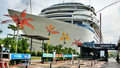
Ferry


Ferries connect Batam to Singapore, Bintan, and Johor Bahru (Malaysia). Five ferry terminals are on the island: Batam Harbour Bay Ferry Terminal, Nongsapura Ferry Terminal, Sekupang, Waterfront City, and Batam Center Ferry Terminal. Connections to Singapore are by way of Harbourfront and Tanah Merah Ferry Terminals run by Singapore Cruise Centre (SCC).
The most recent incident happened on 29 November 2015 when a ferry, 'Sea Prince', hit floating object(s) while en route to Singapore from Batam and began leaking. A total of 97 passengers were rescued on life rafts.[27][28]


Signs showing a picture of a raised finger over a pair of lips have been placed in August 2014 at the Batam Centre International Ferry Terminal to request silence while queuing for immigration to hear names being called and clearly hear instructions given by the immigration officer. Some visitors have been sent back immediately on the first ferry available for flouting this rule. The signs are also applicable at other terminals, but are not strictly enforced.[29]
Trans Batam

Trans Batam serves eight corridors of route:
| Corridor | Origin & destination |
|---|---|
| 1 | Sekupang–Batam Centre |
| 2 | Tanjung Uncang–Batam Centre |
| 3 | Sekupang–Jodoh |
| 4 | Sagulung–Sekupang |
| 5 | Jodoh–Batam Centre |
| 6 | Tanjung Piayu–Batam Centre |
| 7 | Nongsa–Batam Centre |
| 8 | Punggur–Jodoh |
| Source: Batam City Government Transportation Agency[30] | |
Taxi

Taxis in Batam are available almost anywhere at ferry terminals, the airport, shopping malls, hotels, etc. More than 3000 taxis are in Batam. In the early 2000s, Batam commonly had Toyota Corolla taxis. Starting in late 2013, more than 95% of taxis are brand new using the Toyota Limo and Chevrolet Lova.
Airport
Environment
Due to piling works for touristic activity, sand mining, and logging for charcoal business, only 4.2% of Batam Island is covered in mangrove forests, a great decrease from 24% in 1970.[32] Originally, Batam Island had 41,500 hectares of mangrove forests.[33]
Gallery
-
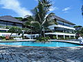 Turi Beach Resort
 -
 The 2014 National MTQ Building in Dataran Engku Putri, Batam Centre
 -
 Great Mosque of Batam
 -
 Pacific Palace Hotel
 -
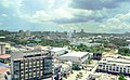
 Batam Centre
 -
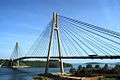 Barelang Bridge
 -
 BCC Hotel Tower and iHotel Baloi
 -
 Batam Harbour Bay downtown, Harbour Bay ferry terminal
 -


See also
References
- ^ a b c d Badan Pusat Statistik, Jakarta, 2023, Kota Batam Dalam Angka 2023 (Katalog-BPS 1102001.2171)
- ^ Richardson, Michael (3 August 1991). "In Today's Booming Asia, Business Knows No Boundaries". The New York Times. Archived from the original on 24 October 2020. Retrieved 22 October 2020.
- ^ "Indonesia-Malaysia-Thailand Growth Triangle (IMT-GT)". imtgt.org. Archived from the original on 27 May 2021. Retrieved 22 October 2017.
- ^ "Country Information – Indonesia-Malaysia-Thailand Growth Triangle (IMT-GT)". imtgt.org. Archived from the original on 23 May 2021. Retrieved 22 October 2017.
- ^ a b Badan Pusat Statistik, Jakarta, 2021.
- ^ "Kota Batam Dalam Angka 2019". www.batamkota.bps.go.id. Archived from the original on 5 June 2021. Retrieved 4 February 2020.
- ^ Firman, Tommy (12 May 2012). "Urbanization and urban development patterns". The Jarkata Post. Archived from the original on 14 February 2021. Retrieved 11 August 2016.
- ^ Post, The Jakarta. "Batam economy in a state of emergency, mayor says". thejakartapost.com. Archived from the original on 23 May 2021. Retrieved 17 June 2017.
- ^ "Pulau Batam Dihuni Orang Selat Sejak 231 Masehi". Tribun Batam (in Indonesian). 18 December 2012. Archived from the original on 18 December 2018. Retrieved 18 December 2018.
- ^ "SYNOP/BUFR observations. Data by months". Meteomanz. Retrieved 22 March 2024.
- ^ "Dari Demokrat Rudi Loncat ke Nasdem". Batam Pos (in Indonesian). 29 August 2016. Archived from the original on 2 October 2017. Retrieved 1 October 2017.
- ^ Biro Pusat Statistik, Jakarta, 2011.
- ^ ISBN 9789814695589– via Google Books.
- ^ "Indonesia: Administrative Division (Provinces, Regencies and Cities) – Population Statistics, Charts and Map". www.citypopulation.de. Archived from the original on 31 December 2015. Retrieved 22 March 2017.
- ^ Leo Suryadinata, Evi Nurvidya Arifin, Aris Anan; Indonesia's population: ethnicity and religion in a changing political landscape, 2003
- ^ "Riau Islands Province in Figures 2017". BPS Kepulauan Riau. Archived from the original on 11 November 2021. Retrieved 22 July 2018.
- ^ a b "BP Batam: 45 years of developing Batam". 3 December 2016. Archived from the original on 3 December 2016. Retrieved 5 December 2016.
- ^ "Indonesia President inaugurates Batam free trade zone". Xinhua General News Service. 19 January 2009.
- ^ Teo, Laurel (19 May 2007). "Indon SEZ rules ready by end-May; Setting of a deadline likely to please potential investors". The Business Times Singapore.
- ^ Widayati, Rully (8 January 2016). "Batam Targetkan 1,7 Juta Kunjungan Turis Asing Tahun Ini". Tempo. Archived from the original on 1 July 2020. Retrieved 1 July 2020.
- ^ "Batam Island – Where Business Meets Pleasure – Indonesia.Travel". indonesia.travel. Archived from the original on 7 November 2017. Retrieved 7 May 2017.
- ^ "Singapura & Malaysia Penyumbang Wisman Terbanyak ke Batam". batampos.co.id. Archived from the original on 14 June 2018. Retrieved 7 May 2017.
- ^ "Bulan Desember Tahun 2014, Jumlah Wisatawan Mancanegara yang Berkunjung ke Kota Batam Mencapai 171.907 Orang". bps.go.id.[permanent dead link]
- ^ Sinaga, Yuni (27 October 2023). "BP Batam records US$1.2 billion foreign investment in January–June". Antara Indonesian News Agency.
- ^ Timmermans, Matt (27 November 2023). "How can foreigners buy property in Indonesia?". Own Property Aboard.
- ^ Yusof, Zaihan (24 December 2021). "Property dispute leaves some Singaporeans anxious". The Straits Times. SPH Media.
- ^ Meah, Natasha; Yin, Chai Hung (1 December 2015). "Batam ferry incident: 'People fended for themselves'". The New Paper. AsiaOne. Archived from the original on 5 January 2016. Retrieved 11 March 2016.
- ^ "Batam ferry incident: Passenger claims overcrowded rafts burst during evacuation". AsiaOne. 30 November 2015. Archived from the original on 5 January 2016. Retrieved 11 March 2016.
- ^ Cheong, Danson (17 August 2014). "Shhh! Be silent at Batam immigration queue or be sent back home". The Straits Times. Archived from the original on 26 August 2014. Retrieved 23 August 2014.
- ^ Public Relations of Batam City Government Transportation Agency (11 August 2020). "Jadwal Keberangkatan Bus Trans Batam di Semua Koridor (Masa Pandemi Covid-19)". Dishub.Batam.go.id (in Indonesian). Batam City Government Transportation Agency. Archived from the original on 20 January 2021. Retrieved 10 October 2020.
- ^ "Airports in Indonesia". Archived from the original on 29 April 2011. Retrieved 3 April 2011.
- ^ "Batam Loses 800 Hectares of Its Mangrove Forest". 15 June 2015. Archived from the original on 21 June 2015. Retrieved 15 June 2015.
- ^ "Batam Mangrove Forest Shrinking in Size". 7 October 2015. Archived from the original on 14 June 2018. Retrieved 8 October 2015.
External links
 Batam travel guide from Wikivoyage
- Official website
- Batam Ferry Terminal Official site Archived 21 December 2018 at the Wayback Machine
- Statistics of Batam Municipality
| Riau Archipelago |
| |
|---|---|---|
| Natuna Islands |
| |
Anambas Islands | ||
Lingga Islands | ||
Regencies and cities of Riau Islands | ||
|---|---|---|
Capital: Tanjungpinang | ||
| Regencies | ||
| Cities | ||
| |||||||||||||||
| Authority control databases: Geographic |
|---|